
Mori Atlas logo
Protected landscapeNeckartal zwischen den Neckarbrücken von Hochberg und Neckarweihingen mit Randgebieten, insbesondere Uhlberg, Lochholz und Beuzlen

A diverse riverine corridor and cultural landscape situated within the Baden-Württemberg region of Germany.

Neckartal zwischen den Neckarbrücken von Hochberg und Neckarweihingen Protected Landscape Map and Geography

Discover the geographic layout of Neckartal zwischen den Neckarbrücken von Hochberg und Neckarweihingen mit Randgebieten, insbesondere Uhlberg, Lochholz und Beuzlen. This protected landscape encompasses historical terraced vineyards, river floodplain meadows, and renaturalized meanders along the Neckar River. Gain context on how these natural features and cultural boundaries define the valley terrain and support ecological connectivity between Ludwigsburg and Remseck.

Neckar valleyfloodplain meadowsrenaturalized floodplainterraced vineyardsorchard meadowsprotected landscape
A stylized vector illustration showing a winding river flowing through a green valley with hills, trees in the foreground, and a sun setting in the background.

Neckartal zwischen den Neckarbrücken von Hochberg und Neckarweihingen mit Randgebieten, insbesondere Uhlberg, Lochholz und Beuzlen

Protected landscape

Park overview

Structured park overview, official facts, and landscape profile for Neckartal Landscape Protection Area between Hochberg and Neckarweihingen

Neckartal Landscape Protection Area between Hochberg and Neckarweihingen park facts, protected area profile, and essential visitor context

Review the core facts for Neckartal Landscape Protection Area between Hochberg and Neckarweihingen, including designation, size, terrain, visitor scale, habitats, and operating context in one park-focused overview.

About Neckartal Landscape Protection Area between Hochberg and Neckarweihingen

The Neckartal zwischen den Neckarbrücken von Hochberg und Neckarweihingen mit Randgebieten, insbesondere Uhlberg, Lochholz und Beuzlen is a protected landscape, or Landschaftsschutzgebiet, that follows a stretch of the Neckar River in the district of Ludwigsburg in Baden-Württemberg. It was formally established in 1988 to preserve a coherent section of valley landscape that integrates river, floodplain, vineyards, meadows and adjacent woodland edge areas into a single protected unit.

Geographically, the area belongs to the natural region of the Neckar basin and lies between the city of Ludwigsburg to the north and the town of Remseck am Neckar to the south. The protected zone extends across parts of several municipal districts: Neckarweihingen, Hoheneck, Poppenweiler and Oßweil on the Ludwigsburg side, and Neckargröningen and Hochberg on the Remseck side. The boundaries of the protected area are defined by the Neckar bridges at Hochberg and Neckarweihingen, with the territory between them forming the core of the designation.

Within the broader valley setting, the area encompasses a diverse mosaic of land uses. Historical terraced vineyards, supported by stone retaining walls and connected by stone steps, shape the lower slopes, while orchard meadows occupy parts of the valley edges. The alluvial meadows of the Neckar floodplain form the ecological heart of the area, and the renaturalized Zugwiesen meander represents a deliberate effort to restore a more natural riverine environment within a heavily used cultural landscape.

Beyond ecological preservation, the protected landscape also serves as a continuous local recreation area for surrounding communities. Its combination of accessible floodplain meadows, vineyard terraces and nearby woodland creates a transitional zone between urban Ludwigsburg, residential parts of Remseck, and the wider open countryside of the Neckar valley. As a protected landscape rather than a stricter nature reserve, the designation allows traditional uses to continue while preventing disruptive development that would alter the valley's character.

Quick facts and research context for Neckartal Landscape Protection Area between Hochberg and Neckarweihingen

The protected landscape was designated on 5 September 1988 by order of the lower nature conservation authority at the Ludwigsburg district office, under landscape protection area number 1.18.056. It lies within the natural region of the Neckar basin and extends across roughly 380 hectares between Ludwigsburg and Remseck am Neckar.

The territory includes parts of the Ludwigsburg districts of Neckarweihingen, Hoheneck, Poppenweiler and Oßweil, together with parts of the Remseck districts of Neckargröningen and Hochberg. Notable named sub-areas referenced in the designation include Uhlberg, Lochholz and Beuzlen. The protected landscape is part of the wider system of Landschaftsschutzgebiete in the Landkreis Ludwigsburg and is administered by that district.

Protection and recognition

A 1988 protected landscape record with IUCN Category V context

Neckartal protected-landscape status and documented designation

Neckartal Landscape Protection Area between Hochberg and Neckarweihingen is documented as a German protected landscape established in 1988 and classified under IUCN Category V. Its structured protection profile connects that designation history with the recorded terrestrial area and WDPA reference without implying management outcomes.

Protection details

Protection scope
Terrestrial
Designated year
1988
Transboundary protection
No
WDPA ID
323152
Park context

Deeper park guide and search-rich context for Neckartal Landscape Protection Area between Hochberg and Neckarweihingen

Neckartal Landscape Protection Area between Hochberg and Neckarweihingen history, landscape, wildlife, and travel context

Explore Neckartal Landscape Protection Area between Hochberg and Neckarweihingen through its history, landscape character, ecosystems, wildlife, conservation priorities, cultural context, and seasonal travel timing in a structured park guide built for atlas discovery and search intent.

Why Neckartal Landscape Protection Area between Hochberg and Neckarweihingen stands out

The protected landscape is best known for combining historical terraced vineyards, natural-stone-walled vineyards with integrated staircases, broad floodplain meadows along the Neckar, and a renaturalized floodplain island at the Zugwiesen. The Zugwiesen, located in a Neckar meander near Ludwigsburg, serve as the area's most recognizable landscape and ecological landmark, illustrating how a working river valley can be returned to a more natural floodplain condition while still being embedded in a long-established cultural landscape.
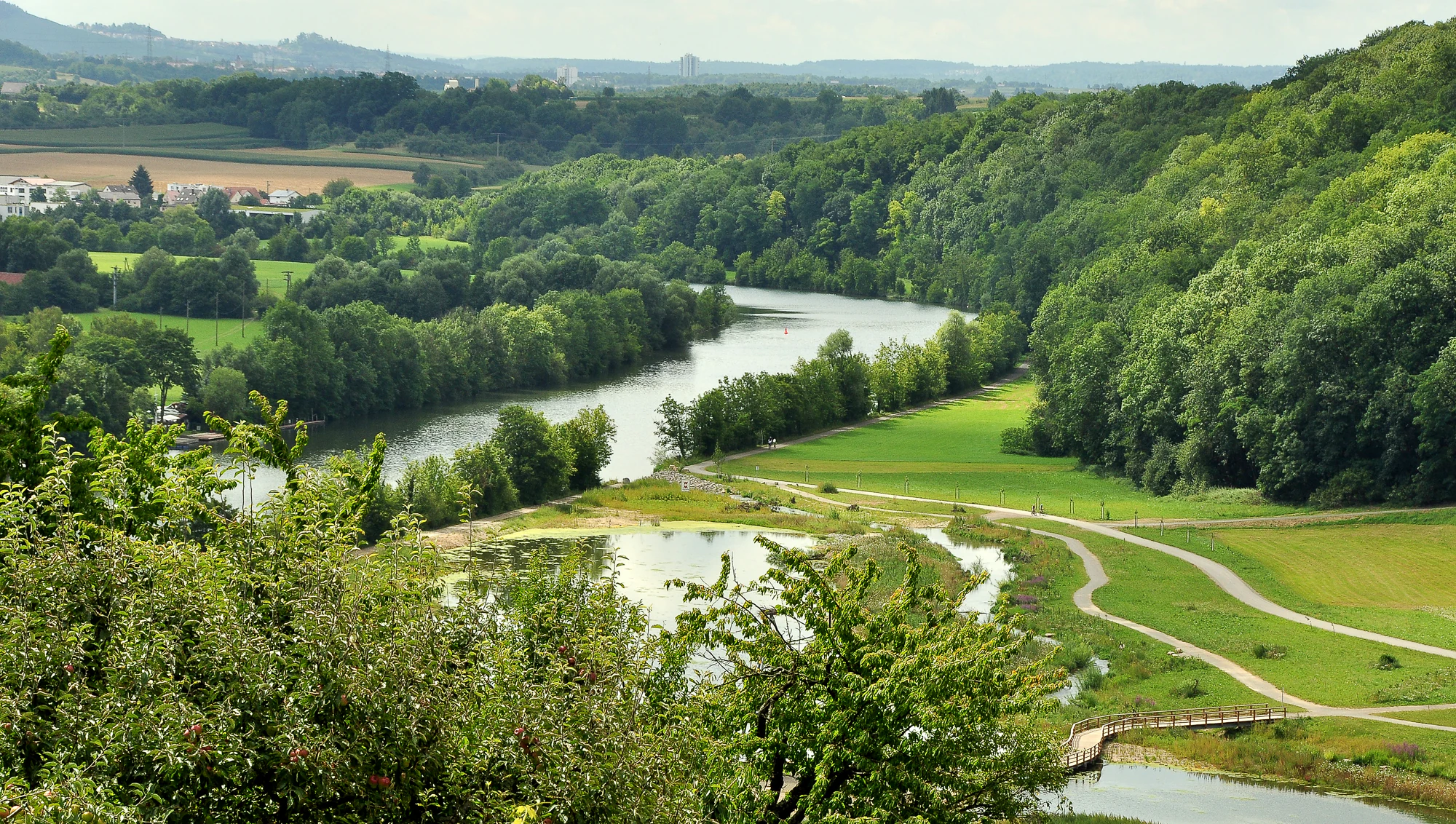
A wide landscape view of the Neckar river winding through a green valley, featuring renatured riverbanks with smaller water bodies, walking paths, and dense forests on the surrounding hills under a clear sky.
Wide view of the renatured Neckar riverbank featuring winding water bodies, green meadows, and forested hills.

Neckartal Landscape Protection Area between Hochberg and Neckarweihingen history and protected-area timeline

The protected landscape was designated on 5 September 1988 through an ordinance issued by the lower nature conservation authority at the Ludwigsburg district office. Its establishment followed the pattern of numerous landscape protection areas created across Baden-Württemberg in the late twentieth century, aimed at preserving traditional mixed cultural landscapes outside of larger nature reserves.

The cultural landscape the area protects is the result of long-standing human use of the Neckar valley, including centuries of viticulture on the terraced slopes and traditional grassland management in the floodplain. Although the landscape protection designation itself dates to 1988, the underlying land use patterns and visible features of terraces, orchard meadows and stone-walled vineyards are considerably older.

A significant ecological milestone within the area is the renaturalization of the Zugwiesen along a Neckar meander, which transformed a previously more regulated riverside section into a near-natural floodplain landscape. The 1988 protection ordinance and subsequent conservation work together reflect an approach that combines preservation of existing cultural landscape elements with active ecological restoration of degraded floodplain sections.

Neckartal Landscape Protection Area between Hochberg and Neckarweihingen landscape and geographic character

The landscape is defined by the Neckar valley between two bridge crossings, the Hochberg bridge in Remseck and the Neckarweihingen bridge in Ludwigsburg. The river flows through this section in broad meanders, creating the conditions for the alluvial floodplain that forms the valley floor. Around the river, the terrain rises gently to support vineyards and orchard meadows on the slopes and edges.

The most distinctive visual feature of the area is the Zugwiesen, a Neckar meander where former cultivated floodplain land has been renaturalized into a more natural riverine landscape. The Zugwiesen illustrate the ecological and scenic value of meandering river sections, where shallow water zones, softwood and hardwood floodplain forest stands, and open wet meadows combine to form a varied habitat mosaic.

Above the floodplain, the valley slopes carry the historical terraced vineyards that contribute strongly to the area's visual character. These terraces, built and maintained with natural stone walls and integrated stone steps, mark the boundary between cultivated valley floor and the higher plateau landscapes Beyond the vineyards, orchard meadows occupy transitional zones, while the named sub-areas of Uhlberg, Lochholz and Beuzlen represent wooded and semi-open edge landscapes that frame the valley.

Neckartal Landscape Protection Area between Hochberg and Neckarweihingen ecosystems, habitats, and plant life

Ecologically, the protected landscape reflects a typical Neckar valley ecosystem, with a transition from aquatic and riparian habitats along the river to terrestrial habitats on the slopes and valley edges. The floodplain meadows of the Neckar are among the most ecologically valuable elements, supporting wet grassland communities and providing habitat connectivity that many species depend on in a heavily populated region.

The Zugwiesen floodplain represents a particularly important habitat area within the designation. Its renaturalized profile includes sections of softwood floodplain forest, areas of open water and wet meadows, and transitional zones where grassland gradually gives way to woodland. This habitat mosaic supports insects, amphibians, and birds associated with the river.

On the slopes, the terraced vineyards and orchard meadows represent cultivated but ecologically valuable habitats. The natural stone walls and terraces provide niches for certain plants and invertebrates, while the orchard meadows support pollinators and bird species typical of traditional European orchard landscapes. The wooded edge areas, including areas like Lochholz, provide additional habitat structure and act as ecological transitions between open valley floor and surrounding forest.

Neckartal Landscape Protection Area between Hochberg and Neckarweihingen wildlife and species highlights

Wildlife interest in the protected landscape centers on species associated with riverine and floodplain environments, complementing species typical of vineyard terraces, orchard meadows and adjacent woodland. The renaturalized Zugwiesen section provides habitat for wetland birds, amphibians, and insects, while the broader mosaic of meadows, hedges and woodland edges supports common native fauna of the Neckar basin.

Terraced vineyards and orchard meadows typically host pollinators, small passerines, and various invertebrates that benefit from the warm microclimate and structural diversity of stone walls and scattered fruit trees. Woodland edge areas such as Lochholz and the Uhlberg area extend available habitat for forest-dwelling and edge species.

Although the protected landscape is not a strict fauna reserve, its ecological function in maintaining habitat connectivity along the Neckar valley is recognized as significant for native flora and fauna within the broadly urbanized Ludwigsburg area.

Neckartal Landscape Protection Area between Hochberg and Neckarweihingen conservation status and protection priorities

The protection ordinance of 5 September 1988 defines the conservation purpose as the preservation and safeguarding of the original character of a varied cultural landscape and its ecological function for the natural environment. The ordinance emphasizes that the habitats of native animal and plant species, along with the attractive overall landscape, should be protected against disruptive changes.

A central conservation focus is the maintenance of the historical terraced vineyards, including their natural stone walls and integrated stone steps, as well as the preservation of orchard meadows and the floodplain meadows of the Neckar valley. These landscape elements are recognized as both ecologically and visually valuable components of the protected area's identity.

The ordinance also restricts new construction and fencing within the protected area, reflecting the intent to preserve the area's open and connected character. The renaturalization of the Zugwiesen meander represents an active conservation achievement, demonstrating how floodplain habitats can be restored along a heavily used river. Taken together, these measures aim to maintain a working cultural landscape that continues to deliver ecological functions rather than being converted into a static reserve.

Neckartal Landscape Protection Area between Hochberg and Neckarweihingen cultural meaning and human context

The landscape protection area lies within a culturally rich stretch of the Neckar valley between Ludwigsburg and Remseck am Neckar. Ludwigsburg is well known for its Baroque palace complex and surrounding gardens, while Remseck and the district communities along this section of the Neckar have long histories of viticulture, agriculture and river-based trade.

Terraced viticulture along the Neckar slopes is a defining element of regional cultural identity, with vineyards forming part of the Württemberg wine-growing tradition. The maintained stone walls and staircases of these terraces are cultural features in their own right, illustrating how generations of winegrowers shaped the valley floor. Orchard meadows in the same region also reflect a long tradition of mixed land use.

The Zugwiesen themselves represent a more recent cultural intervention, in which a former section of cultivated floodplain was deliberately returned to a near-natural state, reflecting evolving attitudes toward river management and the desire to integrate ecological restoration into the surrounding cultural landscape.

Top sights and standout views in Neckartal Landscape Protection Area between Hochberg and Neckarweihingen

Among the area's most notable features are the renaturalized Zugwiesen floodplain meander, the historical terraced vineyards with natural stone walls and staircases between Hochberg and Neckarweihingen, and the broad floodplain meadows of the Neckar valley. The combination of cultivated valley slopes, river floodplain and wooded edge areas creates one of the more varied small protected landscapes in the Landkreis Ludwigsburg.

The designation also stands out for its role as part of a connected network of protected landscapes along the Neckar, linking similar areas upstream and downstream. Within that network, this protected landscape plays a specific role in preserving the cultural and ecological transition between the urban area of Ludwigsburg and the more open Neckar valley heading toward Remseck and Marbach.

Best time to visit Neckartal Landscape Protection Area between Hochberg and Neckarweihingen

The protected landscape can be appreciated across much of the year, but spring and early summer typically bring the freshest expression of the floodplain meadows, blossoming orchard fruit trees, and visible activity around the renaturalized Zugwiesen. Late spring through early summer is also a productive period for observing floodplain and orchard wildlife.

Late summer and early autumn bring the visual peak of the terraced vineyards along the valley slopes, when grape harvest activities enliven the historic stone-terrace landscape and emphasize the cultural character of the area. In winter, the open meadows and exposed stone walls of the vineyards remain accessible and offer a quieter perspective on the valley's structure, although seasonal access to particular paths or sections may vary.

Monthly climate preview

A twelve-month temperature and precipitation record for one valley coordinate

Neckartal monthly climate normals from Hochberg to Neckarweihingen

The Neckartal protected landscape between Hochberg and Neckarweihingen has 1991–2020 climate normals sampled at one representative coordinate near 353 metres. Comparing all twelve months distinguishes average, minimum, and maximum temperatures from daily precipitation while avoiding whole-valley claims from a single point.
Annual mean9 °C
0 °C20 °C
Jan
Feb
Mar
Apr
May13°
Jun17°
Jul20°
Aug20°
Sep15°
Oct10°
Nov
Dec
Warmest month
July

19.6 °C

Coolest month
January

-0.2 °C

Wettest month
July

2.7 mm/day

Driest month
April

1.6 mm/day

Park location guide

Geography guide, regional context, and park location map for Neckartal Landscape Protection Area between Hochberg and Neckarweihingen

Neckartal Landscape Protection Area between Hochberg and Neckarweihingen park geography, regions, and map view in Germany

Understand where Neckartal Landscape Protection Area between Hochberg and Neckarweihingen sits in Germany through a broader geographic reading of the surrounding landscape, nearby location context, and its mapped position within the national park landscape.

How Neckartal Landscape Protection Area between Hochberg and Neckarweihingen fits into Germany

Germany is a federal republic in Western and Central Europe with a population of over 83 million across sixteen constituent states. It is Europe's largest economy by nominal GDP and a major global exporter and importer. The capital is Berlin, and the country borders Denmark, Poland, Czech Republic, Austria, Switzerland, France, Luxembourg, Belgium, and the Netherlands.

Wider geography shaping Neckartal Landscape Protection Area between Hochberg and Neckarweihingen in Germany

Germany is located in Western and Central Europe, spanning 357,022 km². It borders Denmark to the north, Poland and the Czech Republic to the east, Austria and Switzerland to the south, and France, Luxembourg, Belgium, and the Netherlands to the west. The country has coastlines on the Baltic Sea and North Sea to the north, with the Alps located in the southern region.

Map view of Neckartal Landscape Protection Area between Hochberg and Neckarweihingen

Use this park location map to pinpoint Neckartal Landscape Protection Area between Hochberg and Neckarweihingen in Germany, understand its exact geographic position, and read its mapped placement within the surrounding landscape more clearly.

Pigeon | © OpenStreetMap contributors

Location context for Neckartal Landscape Protection Area between Hochberg and Neckarweihingen

Baden-Württemberg

A visual reading of river meanders, floodplain meadows, and valley edges

Neckartal protected-landscape images from Hochberg to Neckarweihingen

View the Neckartal protected landscape between Hochberg and Neckarweihingen through images of terraced slopes, floodplain meadows, and renaturalized river bends. The visual record clarifies how Uhlberg, Lochholz, Beuzlen, and neighboring terrain contribute to ecological continuity along this part of the Neckar.

A wide landscape view of the Neckar river winding through a green valley, featuring renatured riverbanks with smaller water bodies, walking paths, and dense forests on the surrounding hills under a clear sky.

Park atlas

Follow the river corridor into connected protected landscapes and valley terrain

Compare parks beyond the Neckartal from Hochberg to Neckarweihingen

Extend discovery from the Neckartal protected landscape between Hochberg and Neckarweihingen into other parks across the surrounding river region. Comparing nearby records adds context for terraced slopes, floodplain meadows, renaturalized meanders, and the broader ecological connections of the middle Neckar valley.
A watercolor painting of a gentle, rolling landscape with soft green hills, forests, and a light-filled sky.
Protected landscapeBaden-Württemberg
About 4.8 km away#1 closest

South

Hartwald mit Umgebung Protected Landscape and Regional Geographic Map Context

Forested hill topography and traditional orchard landscapes in Baden-Württemberg.

The Hartwald mit Umgebung protected area provides a focal point for understanding regional geography in the Neckar basin. Defined by a forested summit rising above loess plains, the protected landscape preserves valuable stream corridors and ancient burial mounds. This site serves as a vital case study in geological relief inversion and the preservation of culturally shaped natural terrain near the Rems and Neckar river confluence.

Area
2.025 km²
Established
1968
IUCN
V
Protected landscapeBaden-Württemberg
About 5.4 km away#2 closest

Southeast

Unteres Remstal mit Randgebieten Protected Landscape and Regional Geographic Map

Mapping the cultural landscapes of Baden-Württemberg

Unteres Remstal mit Randgebieten represents a key protected landscape in Baden-Württemberg, encompassing the lower Rems river valley. This area preserves a rich mosaic of traditional orchard meadows, scrubby wastelands, and transitional slope reliefs that connect the valley floor to the rising Gäu plateau, forming a vital buffer for regional habitat connectivity.

Area
2.5 km²
Established
1987
IUCN
V
Relief
Lowland
A horizontal watercolor painting of layered, soft green and yellow hills, stylized and minimalist.
Protected landscapeBaden-Wuerttemberg
About 7.2 km away#3 closest

Northwest

Neckartal zwischen Benningen und Großingersheim mit angrenzenden Gebieten Geography and Maps

A preserved Swabian river valley and vineyard landscape

This protected landscape in Baden-Wuerttemberg encompasses the scenic Neckar river bend. The area combines traditional vineyard terraces, riparian corridors, and gentle valley topography to maintain a functional cultural landscape within the Ludwigsburg district.

Area
4.1 km²
Established
1985
IUCN
V
Relief
Lowland
Protected landscapeBaden-Württemberg
About 8.8 km away#4 closest

South

Zuckerberg-Muckensturm Protected Landscape: Geography and Cultural Viticulture Heritage

Exploring the Neckar valley slopes in Baden-Württemberg

Zuckerberg-Muckensturm represents a vital cultural landscape on the outskirts of Stuttgart, characterized by its historical vine-growing terraces and exposed Muschelkalk limestone cliffs. The area serves as a significant case for studying regional earth history and the interplay between urban-adjacent land use and natural geological monuments within the Neckar river valley.

Area
0.505 km²
Established
1987
IUCN
V
Protected landscapeBaden-Württemberg
About 14 km away#5 closest

Southeast

Zipfelbachtal, Korber Kopf, Buocher Höhe, Remstalhänge, Ramsbachtal und Grafenberg Protected Landscape Map

Mapping the Keuper cultural landscape of Baden-Württemberg

Study the intricate topography and land use patterns of this expansive protected area in the Rems-Murr-Kreis. The region preserves a variety of habitats, including vineyard slopes, traditional Streuobst orchards, and forested ravines, providing a clear window into the natural and agricultural heritage of the eastern Stuttgart region.

Area
20.856 km²
Established
1968
IUCN
V
Relief
Upland
A horizontal watercolor painting depicting a soft-focus, stylized landscape of green rolling hills and meadows.
Protected landscapeBaden-Württemberg
About 15 km away#6 closest

Northwest

Gebiete nördlich des Neckars: Käsberg, Felsengärten, and Regional Protected Landscapes

Mapping cultural and ecological terrain in Baden-Württemberg

Trace the boundaries of this 299-hectare protected area stretching across the slopes of the middle Neckar valley. This site safeguards a vital integration of terraced viticulture, limestone rock formations, and orchards, providing a window into the varied cultural geography of the district of Ludwigsburg.

Area
3.07 km²
Established
1988
IUCN
V
Relief
Upland
Protected areaBaden-Württemberg
About 16 km away#7 closest

Southwest

Penal Substitution: Protected Area Mapping and Regional Geography in Baden-Württemberg

Cultural landscape and habitat mosaic overview

Penal Substitution represents a preserved cultural landscape in the German state of Baden-Württemberg, featuring a structured mix of orchard meadows, farmland, and riparian habitats. This area serves as a critical regional green link, where mapped boundaries reveal a complex interplay of agricultural history and active environmental conservation just outside the urban core.

Area
2.586 km²
Established
2004
Relief
Upland
Climate
Temperate
Protected landscapeBaden-Württemberg
About 17 km away#8 closest

West

Wartbiegel - Katharinenlinde und Umgebung: Mapped Protected Landscape and Regional Geography

Traditional orchard mosaic in the Neckar basin, Germany

Discover the geographic structure of Wartbiegel - Katharinenlinde und Umgebung. This protected landscape preserves a unique relief of slopes and agricultural patterns in Baden-Württemberg. The area functions as a vital example of traditional land-use conservation, combining local ecological value with a textured rural landscape near Schwieberdingen.

Area
0.421 km²
Established
1987
IUCN
V
Relief
Upland

Common questions about visiting, size, designation, and location context for Neckartal Landscape Protection Area between Hochberg and Neckarweihingen

Neckartal Landscape Protection Area between Hochberg and Neckarweihingen FAQs for park facts, access, geography, and protected area context

Find quick answers about Neckartal Landscape Protection Area between Hochberg and Neckarweihingen, including protected-area facts, park geography, trail and visitor context, and how the park fits into its surrounding country and regional landscape.
MoriAtlas Explorer

Continue Your Protected Areas Search Across the Global Atlas

Deepen your exploration by continuing the structured search for national parks and protected areas worldwide. Utilize the comprehensive filtering capabilities to compare different conservation landscapes and refine your understanding of global park geography. Discover more about the distribution and characteristics of protected natural areas.

Global natural geography