
Cliffs
Park geography
Analyzing regional terrain, physical land features, and administrative boundaries in West Virginia
Comprehensive Geographic Profile and Mapped Boundaries of New River Gorge National Park and Preserve
Examine the detailed geographic layout of New River Gorge National Park and Preserve, spanning approximately 294.64 square kilometers within West Virginia. This profile documents mapped boundary extents, diverse mountain and riverine landscape features, and environmental characteristics across the park territory.
Related tags
Whitewater RaftingRock ClimbingAppalachian MountainsRiver GorgeCoal Mining History
America's newest national park protecting a spectacular Appalachian river gorge
New River Gorge National Park and Preserve
New River Gorge National Park and Preserve is a United States national park and preserve located in southern West Virginia within the Appalachian Mountains. Established in 1978 as a national river and redesignated as a national park in December 2020, the park protects a 53-mile stretch of the New River Gorge, which is the longest and deepest river gorge in the Appalachian Mountains. The protected area encompasses approximately 72,800 acres of rugged terrain, dramatic cliffs, and dense forests in Fayette and Summers counties. The park is renowned for its exceptional whitewater rafting, world-class rock climbing, significant biodiversity, and rich cultural heritage related to coal mining and railroad history. The New River itself originates in North Carolina, flows north through Virginia, and cuts a spectacular canyon through the West Virginia mountains before joining the Kanawha River, ultimately reaching the Ohio River system.
- Location
- United States of America
- Park type
- National park
- Established
- 2020
- Area
- 294.6 km²
Location overview
National and regional placement within West Virginia
Geographic Location of New River Gorge National Park and Preserve
New River Gorge National Park and Preserve is situated in West Virginia within the United States of America. Records classify the area as an inland, non-transboundary landscape under a single national jurisdiction.
- Countries
- United States of America
- Regions
- West Virginia
- Primary location
- West Virginia
- Geographic setting
- Inland
Boundary and coordinates
Interactive boundary geometry and calculated area metrics
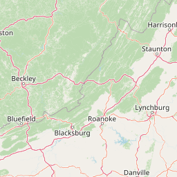
New River Gorge National Park and Preserve Boundary Map and Spatial Extent
Mapped park outlines provide spatial context for understanding territorial extent across the protected landscape. Accompanying measurements detail the recorded area, coordinate limits, centre coordinates, and geographic spans.
- Boundary area
- 292.1 km²
- Boundary perimeter
- 297.9 km
- Northernmost point
- 38.119° N
- Southernmost point
- 37.6742° N
- Easternmost point
- 80.8562° W
- Westernmost point
- 81.1565° W
- Geographic centre
- 37.8736° N, 81.0016° W
- North–south span
- 49.4 km
- East–west span
- 26.4 km
Terrain and natural features
Stored mountain classifications and recorded natural landmarks
New River Gorge National Park and Preserve Terrain and Named Features
Mountain terrain classifications govern the protected landscape within New River Gorge National Park and Preserve. Linked feature cards supply names, types, measurements, and spatial relationships for recorded formations.
Selected named natural features
Waterfalls
Sandstone Falls
Viewpoints
Long Point Viewpoint
Cliffs
Headless Wall
Streams
Meadow Creek
Rivers
New River
Environmental setting
Temperate climate zones, mountain relief, and forest cover classifications
New River Gorge National Park and Preserve Environmental Setting and Classifications
Recorded landscape features, habitat types, and water presence serve as complementary ways to read the physical setting of New River Gorge National Park and Preserve. Each classification connects recorded categories to relevant atlas destinations across the protected area.
- Relief
- Mountain
- Climate
- Temperate
- Water
- Major water bodies
- Forest cover
- Mostly forested
- Seasonality
- Year-round
Landscape features
Mountains · Valleys · Cliffs · Rivers · Waterfalls · Forest
Habitat types
Temperate broadleaf forest · Riverine habitat · Wetland
Park atlas
Map the regional spread of protected landscapes, comparing their unique geographies and conservation profiles around New River Gorge National Park and Preserve.
Explore Appalachian National Parks and Protected Areas Surrounding New River Gorge National Park and Preserve
Explore national parks and other protected areas situated across the broader Appalachian Mountains region, featuring diverse terrain, river gorges, and significant historical landscapes. Compare these conservation landscapes to trace regional park geography, understand varied ecological diversity, and contextualize New River Gorge National Park and Preserve within its natural setting.
Protected landscapeWest Virginia
About 22 km away#1 closest
Northeast

Gauley River National Recreation Area: Appalachian Gorge and Protected River Landscape
Mapped terrain, remote forest corridors, and river-centered geography in West Virginia.
Gauley River National Recreation Area protects a rugged corridor defined by high-volume river channels, sheer rock outcrops, and dense Appalachian hardwood forests. This documentation covers the park's distinct river-centered geography, the interplay of tributary hollows with main river flows, and its status as a critical piece of the broader southern West Virginia mountain landscape.
- Area
- 46.57 km²
- Established
- 1988
- IUCN
- V
- Visitors
- 213.6K annual

Protected landscapeWest Virginia
40 km away#2 closest
Northeast
Monongahela National Forest: Protected Appalachian Landscapes and Regional Geography
Mapping West Virginia wilderness and mountain terrain
Monongahela National Forest protects nearly one million acres of the central Appalachian Mountains. This massive federally managed landscape is defined by the Allegheny Front, the highest peak in the Allegheny range at Spruce Knob, and iconic geological formations like Seneca Rocks. The region represents a vital intersection of climate, hydrology, and biodiversity in the eastern United States, housing eight distinct wilderness areas and complex high-altitude ecosystems.
- Area
- 3,727.8 km²
- Established
- 1920
- Visitors
- 3M annual
- Relief
- Mountain
Wildlife reserveVirginia
42 km away#3 closest
Southeast
Mountain Lake Wilderness: Protected Appalachian Geography and Mountain Landscapes
High-elevation wetlands and ridge-line geography in Virginia
Mountain Lake Wilderness protects a compact yet biologically diverse landscape where cool, moist conditions support rare mountain bogs and red spruce forests. This protected area along the Eastern Continental Divide features rocky outcrops like White Rocks and War Spur Overlook, providing panoramic views of the surrounding Ridge and Valley terrain within the Jefferson National Forest.
- Area
- 44.66 km²
- Established
- 1984
- IUCN
- Ib
- Relief
- Mountain
Wildlife reserveBland County
53 km away#4 closest
South
Kimberling Creek Wilderness: Geography and Protected Land Boundaries in Bland County
A trail-free Appalachian wilderness reserve in Jefferson National Forest
Kimberling Creek Wilderness represents a significant protected enclave in the central Appalachians of Virginia. This detail covers the steep topography extending from Kimberling Creek to the ridgeline of Hogback Mountain, characterized by sheltered cove forests and diverse oak-hickory stands. The area offers a rare glimpse into recovering eastern old-growth forest ecosystems within an entirely trail-free wilderness environment.
- Area
- 23.99 km²
- Established
- 1984
- IUCN
- Ib
- Relief
- Mountain
Wildlife reserveBland County
67 km away#5 closest
South
Hunting Camp Creek Wilderness: Mapped Protected Landscapes in Bland County
Wildlife reserve terrain and Appalachian mountain geography
Hunting Camp Creek Wilderness encompasses an 8,471-acre protected area in Virginia, defined by the Garden Mountain and Brushy Mountain ridges. This wildlife reserve features deep valleys, dense forests, and a core section of the Appalachian Trail, serving as a critical refuge for local mountain biodiversity and wild backcountry exploration.
- Area
- 34.28 km²
- Established
- 2009
- IUCN
- Ib
- Relief
- Mountain
Protected areaVirginia
76 km away#6 closest
South
Garden Mountain Wilderness: Appalachian Protected Area and Regional Landscape Geography
Old-growth forest and ridge-bound Appalachian terrain in Virginia
Garden Mountain Wilderness encompasses a significant Appalachian ridge and the deep Lick Creek valley within western Virginia. This protected area harbors diverse hardwood forests, old-growth remnants, and critical habitat for rare species. The topography is defined by parallel ridges and enclosed valleys, showcasing the geological complexity of the central Appalachians and the importance of localized conservation efforts.
- Area
- 13.48 km²
- Established
- 2009
- IUCN
- Ib
- Relief
- Mountain
Wildlife reserveVirginia
98 km away#7 closest
East
Rough Mountain Wilderness: Mapping Appalachian Ridges and Protected Terrain
Remote wildlife reserve in western Virginia
Spanning over 9,000 acres, Rough Mountain Wilderness provides a rare example of undisturbed Appalachian forest. The area is characterized by consistently steep slopes, sharp ridgeline topography, and a deep sense of isolation within the George Washington and Jefferson National Forests of western Virginia.
- Area
- 38 km²
- Established
- 1987
- IUCN
- Ib
- Relief
- Mountain
Wildlife reserveWythe County
101 km away#8 closest
South
Little Dry Run Wilderness: Protected Wildlife Reserve Map and Geography
A detailed geographic study of southern Blue Ridge terrain.
Little Dry Run Wilderness is a protected mountain basin in Wythe County, marked by its dense hemlock-lined stream corridors and forested ridges. This record outlines the park boundaries, watershed structure, and the complex topography that characterizes this integral component of the Mount Rogers National Recreation Area.
- Area
- 11.57 km²
- Established
- 1984
- IUCN
- Ib
- Relief
- Mountain
MoriAtlas Explorer
Continue Exploring New River Gorge National Park and Preserve's Mapped Landscape and Geography
Discover the detailed protected area boundaries, regional geographic context, and unique landscape features of New River Gorge National Park and Preserve. This destination offers rich insights into Appalachian geography and conservation, inviting a deeper atlas-style exploration of its terrain and protected natural elements.
Browse next
Global natural geography
Explore related park routes
Explore MoriAtlas Global ParksBrowse All MoriAtlas ParksGlobal Park Map DiscoveryMoriAtlas: Browse All CountriesBrowse All MoriAtlas ContinentsNational Park Environment AtlasGrand Canyon National Park AtlasYellowstone National Park AtlasYosemite National Park Atlas and GeographySerengeti National Park AtlasGalápagos National Park Protected LandscapeBanff National Park Geography and AtlasKruger National Park Atlas EntryUluṟu-Kata Tjuṯa National Park AtlasExplore Uluru-Kata Tjuta National Park GeographyPlitvice Lakes National Park AtlasFiordland National Park Protected LandscapeGreat Smoky Mountains National Park AtlasAfghanistan National Parks and Protected AreasAlbania National Parks and Protected AreasAlgeria National Parks and Protected AreasAmerican Samoa National Parks and Protected AreasAndorra National Parks and Protected AreasAngola National Parks and Protected AreasAntarctica National Parks and Protected AreasAntigua and Barbuda Park List