
Mori Atlas logo
Protected landscapeNorth West Sutherland National Scenic Area

Examining the quartzite peaks, coastal lochs, and protected terrain of Northwest Scotland

North West Sutherland National Scenic Area: A Detailed Geographic Atlas of Highland Landscapes

The North West Sutherland National Scenic Area encompasses a stark, glaciated landscape in the far northwest of Scotland. This protected region features the iconic quartzite peaks of Foinaven, Arkle, and Ben Stack rising above the ancient Lewisian gneiss of the Highland terrain. By examining the mapped boundaries and complex knock and lochan topography, the platform provides a clear geographic overview of these remote mountains, indented sea lochs, and sheltered coastal inlets.

highland landscapequartzite mountainslewisian gneissatlantic coastlinesea lochsbiodiversity
A stylized vector illustration showing a paved road curving towards a green mountain peak, with a wooden fence and gate in the foreground, under a pastel sky with clouds.

North West Sutherland National Scenic Area

Protected landscape

Park overview

Structured park overview, official facts, and landscape profile for North West Sutherland National Scenic Area

North West Sutherland National Scenic Area park facts, protected area profile, and essential visitor context

Review the core facts for North West Sutherland National Scenic Area, including designation, size, terrain, visitor scale, habitats, and operating context in one park-focused overview.

About North West Sutherland National Scenic Area

North West Sutherland National Scenic Area is a protected landscape in the far northwest of the Scottish Highlands, covering the mountainous interior and a stretch of deeply indented Atlantic coastline. Situated within the historic county of Sutherland and the modern Highland council area, it represents one of the most remote and visually dramatic parts of mainland Britain.

The protected landscape is built around three principal mountains, Foinaven, Arkle, and Ben Stack, each shaped by the underlying geology of quartzite resting on far older Lewisian gneiss. This geological relationship creates a striking visual contrast: the summits and flanks of Foinaven and Arkle form pale, broken expanses of white quartzite scree, occasionally interrupted by tiered crags, while the lower ground to the west displays the classic knock and lochan topography of glaciated gneiss. Ben Stack rises as a shapely cone, Arkle as a rounded whale-back ridge, and Foinaven as a long slab divided into separate summits, giving the area a varied mountain silhouette.

Beyond the mountains, the area extends to a rugged coastline shaped by Loch Laxford and the surrounding sea lochs, with bare rocky shores rather than the wooded inlets typical of more southerly Highland coasts. From selected beaches within the area, the towering sandstone cliffs of Handa Island come into view, hosting major seabird colonies that contribute to the area's ecological importance. Settlement is sparse, limited to a few small coastal crofting townships such as Fanagmore and Foindle, with isolated shooting lodges further inland; woodland is scarce and soils are thin throughout most of the area.

The designation is more than a scenic label, as the national scenic area framework is layered with international and national conservation designations. Handa Island and adjacent waters are protected for breeding seabirds, the Foinaven-Arkle mountains are protected for golden eagles, and Foinaven is additionally designated for its habitats, freshwater pearl mussels, and otters. Loch Laxford carries further recognition for its marine reefs and sheltered inlets. Together, these overlapping protections highlight the area's value as both a landscape and a habitat complex at the northwestern edge of Europe.

Quick facts and research context for North West Sutherland National Scenic Area

North West Sutherland is a national scenic area covering 26,565 hectares, of which 23,415 hectares are land and 3,151 hectares are marine. It lies within the Highland council area in northwestern Scotland, encompassing the mountains of Foinaven, Arkle, and Ben Stack, plus the coastal scenery of Loch Laxford and Handa Island.

The area was first identified in a 1978 landscape review and redesignated as a national scenic area in 2010 under the Nature Conservation (Scotland) Act. It is one of 40 national scenic areas in Scotland and is managed by NatureScot, with planning guidance administered through Highland Council. Several Natura 2000 sites overlap with the scenic designation, including SPAs for seabirds and golden eagles and SACs for habitats and freshwater species.

Protection and recognition

Examine the mixed protection scope and official designation timeline for this protected landscape.

North West Sutherland National Scenic Area Protection Status and Designation History

North West Sutherland National Scenic Area maintains a documented protection status established in two thousand and ten, reflecting its mixed conservation framework. Structured records outline the official designation history and management scope without relying on external recognition frameworks.

Protection details

Protection scope
Mixed
Designated year
2010
Transboundary protection
No
Park context

Deeper park guide and search-rich context for North West Sutherland National Scenic Area

North West Sutherland National Scenic Area history, landscape, wildlife, and travel context

Explore North West Sutherland National Scenic Area through its history, landscape character, ecosystems, wildlife, conservation priorities, cultural context, and seasonal travel timing in a structured park guide built for atlas discovery and search intent.

Why North West Sutherland National Scenic Area stands out

The area is best known for the dramatic trio of quartzite mountains, Foinaven, Arkle, and Ben Stack, which rise sharply above an older gneiss landscape and define the visual identity of the region. Foinaven and Arkle are particularly distinctive for their pale, broken quartzite scree slopes, tiered crags, and stark, almost desert-like character. Equally important to the area's reputation is its Atlantic coastline, especially the indented sea lochs and sea cliffs around Loch Laxford and Handa Island. The combination of bare mountain terrain, rocky loch-side scenery, and isolated seabird cliffs gives North West Sutherland a sense of remoteness and integrity that distinguishes it from many other Highland landscapes.
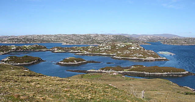
A wide landscape view of a blue loch dotted with small, rocky, grass-covered islands under a clear blue sky, seen from a grassy hillside.
View of the islands in Loch Laxford from Cnoc Druim na Coille.

North West Sutherland National Scenic Area history and protected-area timeline

The national scenic area designation has its roots in post-Second World War concern over the future of Scotland's finest landscapes. In 1945, a committee chaired by Sir Douglas Ramsay published a report identifying five areas considered worthy of a higher level of protection: Loch Lomond and the Trossachs, the Cairngorms, Glen Coe, Ben Nevis and Black Mount, Wester Ross, and the Glen Strathfarrar, Glen Affric and Glen Cannich area. These were initially designated as national park direction areas, allowing central government to review certain local planning decisions in order to safeguard landscape quality.

A subsequent review of landscape protection in 1978 examined Scotland more broadly and identified additional areas, including the remote northwestern parts of Sutherland, as worthy of formal recognition. This led to the formal establishment of the national scenic area designation in 1981, replacing the earlier direction areas and incorporating North West Sutherland as one of the original nationally designated landscapes. Although the boundary of the area remains as originally mapped in 1978, the legislative basis for the designation was updated in 2010, when the Nature Conservation (Scotland) Act replaced the earlier framework.

Unlike Scotland's two national parks, the national scenic areas do not have dedicated park authorities. Instead, planning protection operates through local authorities, in this case Highland Council, which can produce management strategies for the areas in its jurisdiction. In practice, only the three national scenic areas within Dumfries and Galloway currently have active management strategies, meaning protection in North West Sutherland relies primarily on the planning framework and the overlapping international designations.

North West Sutherland National Scenic Area landscape and geographic character

The landscape of North West Sutherland is defined above all by the relationship between three mountains and the older terrain that surrounds them. Foinaven, Arkle, and Ben Stack are built from quartzite that rests dramatically on much older Lewisian gneiss, creating a visually layered scene in which pale, rubble-strewn summits rise above a darker, glaciated lowland. The summits and flanks of Foinaven and Arkle in particular form a stark, almost desert-like expanse of white quartzite scree, broken occasionally by lines of tiered crags.

Ben Stack stands apart from its neighbours as a shapely remnant cone reaching 721 metres, while Arkle presents a smooth, whale-back profile at 787 metres. Foinaven, the highest of the three at 909 metres, is a long slab broken into separate summits and stretches across a substantial portion of the area's interior. Together the three mountains form the visual and geological core of the national scenic area.

The lower ground to the west of these peaks displays a classic knock and lochan topography, formed on the ancient Lewisian gneiss and characterised by countless small rock mounds and lochans. This bare, rocky terrain extends down to the coast, where Loch Laxford and its associated sea lochs mirror the same geological character through their indented, rocky shorelines. There are few wooded inlets; instead, exposed ridges and sheltered pockets of sediment define the shoreline, with occasional small beaches that frame views toward the sandstone cliffs of Handa Island. Soils across the area are thin and woodland is rare, leaving much of the landscape open, exposed, and largely uncultivated.
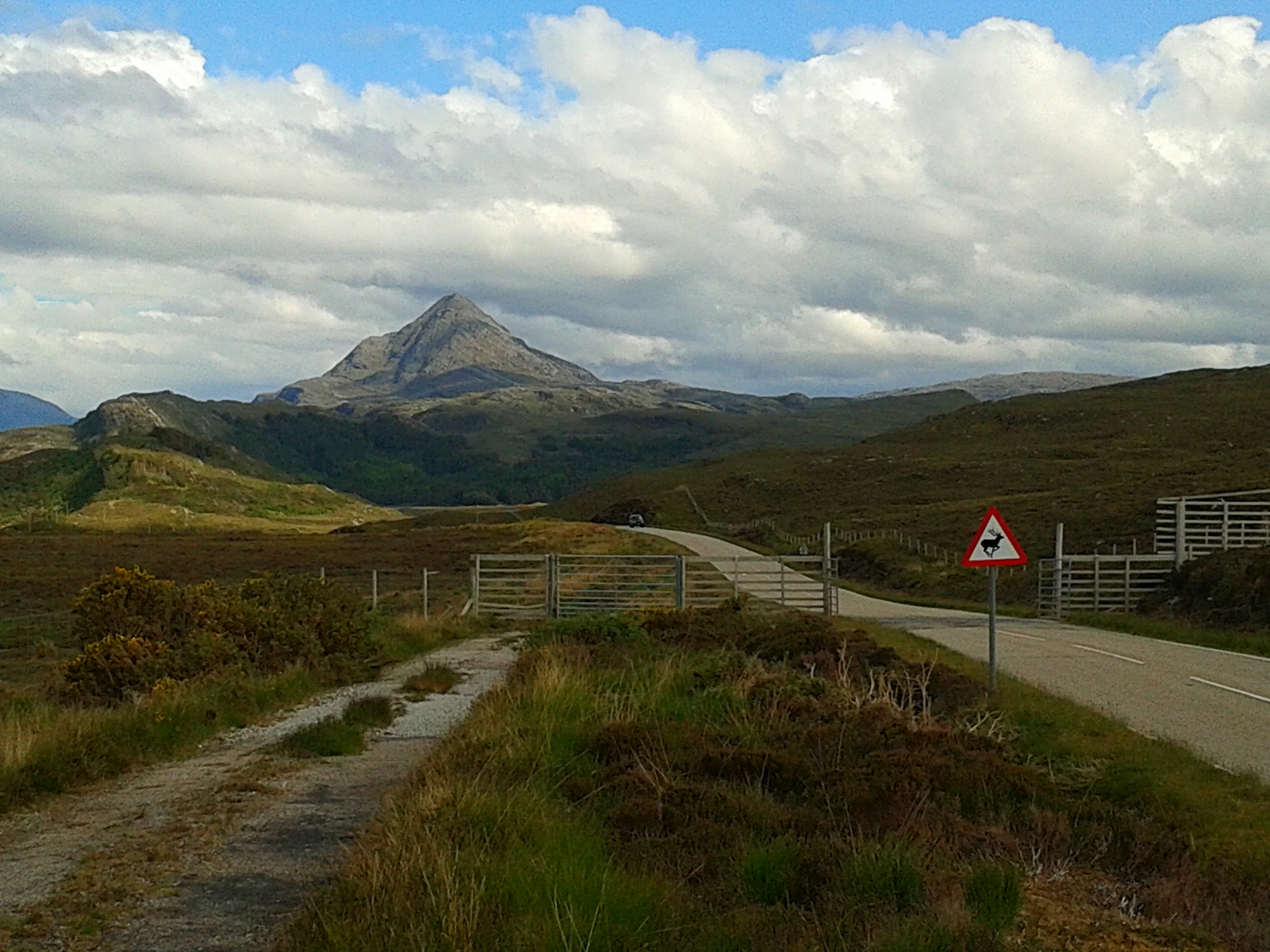
A conical mountain peak rises in the distance behind rolling moorland, with a paved road, metal cattle grid gate, and a triangular warning sign in the foreground under a partly cloudy sky
Ben Stack's distinctive conical peak rises above the Sutherland moorland, with a road and cattle grid in the foreground

North West Sutherland National Scenic Area ecosystems, habitats, and plant life

The ecological character of North West Sutherland is shaped by its underlying geology and exposure to Atlantic weather patterns. Thin soils, exposed rock, and limited woodland cover mean that habitats are predominantly open montane, heath, and maritime types, with river and loch systems scattered through the lower ground. The combination of bare rock, peat, and water in the knock and lochan landscape supports a range of specialist upland and freshwater habitats.

Marine and coastal habitats are equally significant. Loch Laxford operates as a sheltered sea loch system on one side while remaining exposed to Atlantic conditions at its outer margins, producing a mosaic of rocky reef, sediment, and intertidal areas. The coastline is largely unwooded and rocky, with only occasional sheltered beaches. Around Handa Island, the marine environment meets dramatic sandstone cliff habitats that host dense breeding bird colonies.

Freshwater systems include lochs and burns threaded through the gneiss lowlands and flowing from the quartzite uplands. These waters support populations of freshwater pearl mussels, one of the most threatened freshwater species in Europe, and sustain populations of otters that range from freshwater lochs and burns out into the sea lochs. The overlap of terrestrial, freshwater, and marine habitats within a relatively compact area gives North West Sutherland a notably layered ecological profile.

North West Sutherland National Scenic Area wildlife and species highlights

Wildlife in North West Sutherland is strongly linked to two particular concentrations: the open mountain country around Foinaven and Arkle, and the cliffs and sea around Handa Island. The mountains support a breeding population of golden eagles, one of the most significant raptor strongholds in northwest Scotland and a species closely associated with the wild character of the area.

On and around Handa Island, breeding seabird colonies are a defining feature of the area's wildlife identity. The island's Special Protection Area designation lists fulmar, great skua, guillemot, kittiwake, and razorbill among its priority species, forming part of the wider seabird assemblage characteristic of the Atlantic edge of Sutherland.

Freshwater and coastal wildlife is also notable. Foinaven is recognised as a Special Area of Conservation partly because of the presence of freshwater pearl mussels, a highly sensitive indicator species for clean, undisturbed river systems. Otters utilise both the freshwater lochs and burns and the sheltered sea lochs around the coast, including Loch Laxford. Although not recorded species-by-species in detail here, the wider assemblage of upland birds, waders, and marine life typical of far northwestern Scotland is characteristic of the area's open, lightly populated landscape.

North West Sutherland National Scenic Area conservation status and protection priorities

Conservation recognition in North West Sutherland operates through a stack of overlapping national and international designations. The national scenic area framework itself is a landscape-based protection, focused on safeguarding scenery through the planning system and managed by NatureScot in cooperation with Highland Council, although unlike Scotland's national parks it has no dedicated park authority.

Within this broader scenic framework, the area contains two Special Protection Areas and two Special Areas of Conservation. Handa Island and its surrounding waters are designated as an SPA for breeding seabirds, with fulmar, great skua, guillemot, kittiwake, and razorbill listed as priority species, while the island is managed by the Scottish Wildlife Trust. The mountains around Foinaven and Arkle are designated as an SPA because of their breeding golden eagle population, one of the most important raptor areas in the Scottish Highlands.

The Foinaven area additionally carries SAC status, recognising priority habitats and the presence of freshwater pearl mussels and otters. Loch Laxford is also protected as an SPA for its marine environment, including reefs and shallow inlets and bays; it holds the most extensive shoreline of sheltered sediment in the far northwest of Scotland. The layered nature of these designations reflects a recognition that the area's scenic, geological, and ecological values reinforce one another, justifying protection beyond what any single designation could provide.

North West Sutherland National Scenic Area cultural meaning and human context

The cultural context of North West Sutherland is defined by the persistence of a very traditional, sparsely populated Highland landscape. Much of the area is uninhabited and uncultivated, with human settlement limited to a few small crofting townships along the coast such as Fanagmore and Foindle, alongside isolated shooting lodges in the interior. This pattern reflects centuries of Highland land use, in which marginal coastal and upland areas supported small crofting communities alongside extensive sporting estates.

In Scottish Gaelic the area is known as Ceathramh Garb, meaning the "Rough Quarter", a name that captures the wild, exposed character of the terrain. The pattern of crofting, estate management, and Gaelic place names links the present landscape to a long history of human presence in some of the most marginal conditions of mainland Scotland, even though modern settlement remains extremely sparse.

The land also carries traces of older histories embedded in its topography, including the Moine Thrust, a geological boundary that is itself part of the natural heritage of the area as much as it is a feature of scientific interest. Although the area is not defined by built heritage in the way some other Scottish landscapes are, its crofting townships, Gaelic identity, and the relationship between remote human settlement and a dominant natural environment form a recognisable regional cultural character.

Top sights and standout views in North West Sutherland National Scenic Area

The defining highlights of North West Sutherland are the three quartzite mountains, Foinaven, Arkle, and Ben Stack, whose pale slopes and dramatic profiles are the visual signature of the area. The 1978 landscape review that justified the designation described these mountains as forming a stark desert of white quartzite scree broken by tiered crags, set against the darker knock and lochan topography of the surrounding gneiss.

Equally striking is the Atlantic coastline around Loch Laxford and Handa Island, where rocky inlets, sheltered pockets of sediment, and towering seabird cliffs produce some of the most uninterrupted coastal scenery in northwestern Scotland. The combination of remote mountain terrain, indented sea lochs, and protected bird cliffs gives the area a layered identity that supports both landscape and biodiversity-focused designations at national and European level.

Best time to visit North West Sutherland National Scenic Area

The area's atmosphere and accessibility vary meaningfully with the seasons. Spring and early summer bring longer days, fresh growth on the lower ground, and the most active period for breeding birds, including the seabird colonies on Handa and golden eagle activity around Foinaven and Arkle. This is also when marine and freshwater wildlife in Loch Laxford and surrounding waters tends to be most visible.

Summer and early autumn are typically the most favourable periods for general appreciation of the landscape, with more settled weather, drier ground underfoot, and extended daylight for reaching the more remote viewpoints over the mountains and coastline. Winter brings short days, harsher weather, and snow on the higher summits, which can transform the white quartzite slopes into an even more stark and luminous scene, though access to higher ground becomes considerably more demanding.
Monthly climate preview

Long-term representative temperature and precipitation patterns across the coordinate profile

North West Sutherland National Scenic Area Climate Normals and Weather by Month

Historical climate records outline the measured annual temperature rhythm and daily precipitation rates across a representative coordinate in North West Sutherland National Scenic Area. Examining the complete twelve-month normals profile provides deeper analytical context for long-term meteorological trends.
Annual mean9 °C
5 °C13 °C
Jan
Feb
Mar
Apr
May
Jun11°
Jul13°
Aug13°
Sep12°
Oct10°
Nov
Dec
Warmest month
August

13.2 °C

Coolest month
February

4.9 °C

Wettest month
January

4.4 mm/day

Driest month
May

2.7 mm/day

Park location guide

Geography guide, regional context, and park location map for North West Sutherland National Scenic Area

North West Sutherland National Scenic Area park geography, regions, and map view in United Kingdom

Understand where North West Sutherland National Scenic Area sits in United Kingdom through a broader geographic reading of the surrounding landscape, nearby location context, and its mapped position within the national park landscape.

How North West Sutherland National Scenic Area fits into United Kingdom

The United Kingdom is a parliamentary constitutional monarchy located in northwestern Europe, consisting of four constituent countries: England, Scotland, Wales, and Northern Ireland. As a major global power with over 69 million residents, it maintains significant international influence in politics, economics, and culture.

Wider geography shaping North West Sutherland National Scenic Area in United Kingdom

The United Kingdom is an island nation located in northwestern Europe, surrounded by the Atlantic Ocean, North Sea, English Channel, Celtic Sea, and Irish Sea. It shares a land border with the Republic of Ireland to the west. The territory includes the island of Great Britain, the northeastern portion of Ireland, and most of the smaller British Isles islands.

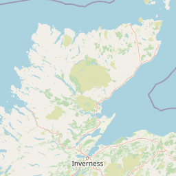
Map view of North West Sutherland National Scenic Area

Use this park location map to pinpoint North West Sutherland National Scenic Area in United Kingdom, understand its exact geographic position, and read its mapped placement within the surrounding landscape more clearly.

Pigeon | © OpenStreetMap contributors

Location context for North West Sutherland National Scenic Area

HighlandScotland

Visual reference of quartzite mountains, ancient gneiss terrain, and rugged Atlantic sea lochs

North West Sutherland National Scenic Area Photos and Landscape Scenery

Visual documentation captures the stark contrast between pale quartzite summit screes and ancient Lewisian gneiss lowlands across the protected expanse. Photographic records reveal the distinctive topography, remote mountain environments, and indented coastal features defining the region.

A wide landscape view of a blue loch dotted with small, rocky, grass-covered islands under a clear blue sky, seen from a grassy hillside.

A tall, narrow sea stack of layered rock rising from blue ocean water with white waves, viewed from above. The rock has green vegetation on top and seabirds are visible on its ledges.

A conical mountain peak rises in the distance behind rolling moorland, with a paved road, metal cattle grid gate, and a triangular warning sign in the foreground under a partly cloudy sky

Park atlas

Compare adjacent Highland terrain, rugged mountain ranges, and Atlantic coastal landscapes.

Other Parks and Protected Areas Near North West Sutherland National Scenic Area

Explore nearby national parks and protected areas that share the rugged geography of North West Sutherland National Scenic Area. Comparing adjacent regional landscapes reveals broader patterns of ancient geology, remote wilderness, and coastal terrain.
A watercolor painting showing a wide, sweeping landscape of green hills, a winding stream, and flat boggy terrain under a soft, light-colored sky.
Nature reserveScotland
About 71 km away#1 closest

East

Flow Country: Geography and Protected Landscape Analysis of Scotland's Blanket Bog

Northern Scotland's vast, waterlogged peatland ecosystem.

The Flow Country is defined by its extensive, open peatland terrain stretching across Caithness and Sutherland. This nature reserve serves as a critical geographic study area for understanding blanket bog formation, carbon storage, and the restoration of fragile wetland habitats in northern Europe.

Area
4,000 km²
Relief
Lowland
Scope
Terrestrial
Water
Water-dominated
Watercolor painting of soft rolling dunes, green hills, and light clouds.
Protected areaSutherland
About 72 km away#2 closest

Southeast

Coul Links Protected Area: Coastal Dune and Heathland Geography in Sutherland, Scotland

A study of coastal dune succession and wetland terrain

Coul Links serves as a quintessential example of a Scottish coastal links landscape, tracing a continuous path from active beach fronts through to stable, juniper-rich heathland. Situated in Sutherland, the site offers a window into the formation of dune slacks, seasonal freshwater lochans, and the ecological dynamics of a complex, interwoven coastal system.

Relief
Lowland
Climate
Temperate
Access
Easy access
Scope
Terrestrial
Nature reserveScotland
About 80 km away#3 closest

East

East Caithness Cliffs Nature Reserve: Regional Geography and Coastal Protected Area Atlas

Coastal sandstone cliffs and maritime heath habitats in northern Scotland.

Examine the layered conservation architecture and physical geography of East Caithness Cliffs. This site serves as a prime example of protected northern coastal terrain, where sandstone formations and maritime heath support vast seabird populations across a mosaic of land and sea boundaries.

Area
116.96 km²
Established
1996
Relief
Upland
Climate
Temperate
Protected landscapeHighland
About 81 km away#4 closest

South

Wester Ross National Scenic Area: Protected Highland Mountain and Coastal Landscape Atlas

Geographic mapping of the Northwest Highlands terrain

Wester Ross National Scenic Area spans vast stretches of the Northwest Highlands, characterized by towering Torridonian sandstone peaks and deeply carved sea lochs. This protected region integrates ancient Scots pine forests, glacial-carved glens, and complex coastal environments into one of the most recognizable geographic features of Scotland. The landscape serves as a vital record of geological heritage and high-latitude biodiversity within the Highland administrative region.

Area
1,634.58 km²
Established
1981
Visitors
70K annual
Relief
Mountain
A pale, minimalist watercolor painting showing gentle hills, a curved shoreline, and sparse grass against a white background.
Protected areaNa h-Eileanan Siar
About 101 km away#5 closest

West

Isle of Lewis Protected Area: Geography, Coastal Landscapes, and Highland Terrain

Mapped regional geography of the Outer Hebrides

The Isle of Lewis represents a significant protected landscape defined by its ancient geological roots and diverse coastal ecosystems. From the lime-rich machair grasslands of the west to the deeply indented sea lochs of the east, this area offers a unique perspective on the physical geography and inland peatland networks of the North Atlantic.

Area
1,770 km²
Visitors
219K annual
Relief
Mixed relief
Climate
Temperate
A minimalist, stylized vector illustration of coastal cliffs meeting the sea, with a lighthouse visible in the distance on top of the headland.
Marine protected areaHighland
About 109 km away#6 closest

East

Noss Head Marine Protected Area: Highland Coastal and Benthic Geography

Exploring the rocky cliffs and offshore mussel habitats of Northern Scotland.

Noss Head is a notable marine protected area located on the Caithness coast of the Scottish Highlands. The site is defined by its rugged coastal cliffs and an expansive, nationally important horse mussel bed that occupies the seabed at depths between 35 and 45 metres. This area represents a core study in North Atlantic benthic ecology and dramatic maritime landforms.

Area
8 km²
Established
2014
IUCN
IV
Relief
Lowland
Protected landscapeHighland
About 114 km away#7 closest

Southwest

Trotternish National Scenic Area: A Geographic Atlas of the Isle of Skye Protected Landscape

Basalt escarpments and geologic landmarks in the Scottish Highlands

Trotternish National Scenic Area features a long, continuous basalt escarpment that defines the spine of northern Skye. This protected landscape contains complex ridge formations, dramatic coastal cliffs, and a rich record of Jurassic geology. Learn about the physical geography, mapped extent, and natural terrain that make this region a key protected area within the Highland geography of Scotland.

Established
1981
Relief
Upland
Climate
Temperate
Access
Moderate access
A soft, impressionistic watercolor painting of a Scottish loch surrounded by rolling green hills and distant mountain silhouettes.
Marine protected areaRoss and Cromarty
About 118 km away#8 closest

South

Loch Carron Marine Protected Area: Coastal Geography and Protected Seabed Landscape Atlas

Exploring the tidal basins and underwater terrain of Ross and Cromarty.

Loch Carron stands as a landmark marine protected area defined by its dramatic underwater depth changes and robust tidal currents. This protected sea loch features the world's largest flame shell colony nestled beneath the cliffs at Strome Castle. The surrounding Highland geography of Ross and Cromarty creates a compressed, mountain-framed landscape that influences the rich ecological character of this essential coastal habitat.

Area
23 km²
Established
2019
Relief
Lowland
Climate
Temperate

Common questions about visiting, size, designation, and location context for North West Sutherland National Scenic Area

North West Sutherland National Scenic Area FAQs for park facts, access, geography, and protected area context

Find quick answers about North West Sutherland National Scenic Area, including protected-area facts, park geography, trail and visitor context, and how the park fits into its surrounding country and regional landscape.
MoriAtlas Explorer

Continue Your Protected Areas Search Across the Global Atlas

Deepen your exploration by continuing the structured search for national parks and protected areas worldwide. Utilize the comprehensive filtering capabilities to compare different conservation landscapes and refine your understanding of global park geography. Discover more about the distribution and characteristics of protected natural areas.

Global natural geography