

Mori Atlas logo
Nature reserveNylsvley Nature Reserve

An analysis of the seasonal floodplain, reedbeds, and surrounding bushveld woodland landscapes

Nylsvley Nature Reserve: Mapping the Protected Floodplain and Wetland Geography of Limpopo

Nylsvley Nature Reserve serves as a critical protected area within the Limpopo Province, defined by its unique hydrology and the seasonally inundated floodplain of the Nyl River. This atlas entry provides an overview of the reserve's shifting mosaic of reedbeds, grasslands, and savanna bushveld. By protecting an extensive upper catchment system, the reserve offers a primary reference point for inland wetland conservation and floodplain ecology within the northern interior of South Africa.

wetlandfloodplainRamsar sitebird sanctuarywaterfowlreedbeds

Nylsvley Nature Reserve

Nature reserve

Park overview

Structured park overview, official facts, and landscape profile for Nylsvley Nature Reserve

Nylsvley Nature Reserve park facts, protected area profile, and essential visitor context

Review the core facts for Nylsvley Nature Reserve, including designation, size, terrain, visitor scale, habitats, and operating context in one park-focused overview.

About Nylsvley Nature Reserve

Nylsvley Nature Reserve is a compact but ecologically rich protected landscape in the northern interior of South Africa. Centered on the floodplain of the Nyl River, it captures one of the most significant seasonal wetland systems in the country and serves as a reference site for floodplain conservation in the Limpopo Province.

The reserve occupies a portion of the upper Nyl River floodplain, a landscape shaped by extremely flat topography and seasonal flooding rather than by dramatic relief. When rains fill the system, shallow water spreads across a broad plain, transforming the area into a mosaic of open water, reedbeds, and saturated grasslands. As the flood recedes, the land shifts gradually back into drier conditions, supporting grassveld and a transition into open woodland on the better-drained edges. This rhythmic alternation between wet and dry phases defines the ecology of the reserve and supports both aquatic and terrestrial species.

From a biodiversity standpoint, Nylsvley is disproportionately important for its size. Its bird list exceeds 370 species, a figure that places it among the richest birding sites in South Africa and that reflects the interface between aquatic and terrestrial habitats. The reserve also stands out botanically through its wild rice populations, the only known occurrence of Oryza longistaminata in the country. Larger mammals of regional conservation interest are present in the surrounding bushveld, and the combination of floodplain habitat and adjacent woodland creates an unusually varied ecological setting for an inland reserve.

In conservation terms, Nylsvley is recognized as a wetland of international importance under the Ramsar Convention, giving it formal standing alongside other globally significant wetland systems. This status underscores both the ecological value of the site and the importance of protecting its hydrological regime, which is central to the persistence of its habitats and species.

Quick facts and research context for Nylsvley Nature Reserve

Nylsvley Nature Reserve lies near the town of Mookgophong in the Limpopo Province of South Africa. It covers about 40 km2 and protects around 20% of the floodplain of the Nyl River, the uppermost reach of the Mogalakwena River. The reserve was formally established and designated as a Ramsar wetland site on 7 July 1998. It is administered by the Limpopo Department of Economic Development, Environment and Tourism, and supports an exceptionally diverse bird community dominated by waterfowl during the flood season.

Protection and recognition

Documented terrestrial protected area designation history and Ramsar wetland recognition

Nylsvley Nature Reserve Protection Status and International Recognition

Nylsvley Nature Reserve holds documented terrestrial protected area status established in 1998. Official records incorporate designated Ramsar wetland recognition sources for the protected landscape.

International recognition

Protection details

Protection scope
Terrestrial
Designated year
1998
Transboundary protection
No
Park context

Deeper park guide and search-rich context for Nylsvley Nature Reserve

Nylsvley Nature Reserve history, landscape, wildlife, and travel context

Explore Nylsvley Nature Reserve through its history, landscape character, ecosystems, wildlife, conservation priorities, cultural context, and seasonal travel timing in a structured park guide built for atlas discovery and search intent.

Why Nylsvley Nature Reserve stands out

Nylsvley is best known as one of South Africa's most important inland wetland bird sanctuaries, recognized internationally through its Ramsar designation. The reserve's defining feature is a large, shallow floodplain that fills seasonally and supports enormous concentrations of waterbirds, with more than 100 waterfowl species recorded and tens of thousands of birds present during peak floods. It is also recognized for hosting the only wild rice (Oryza longistaminata) populations in South Africa and for the presence of roan antelope and tsessebe on the surrounding bushveld.
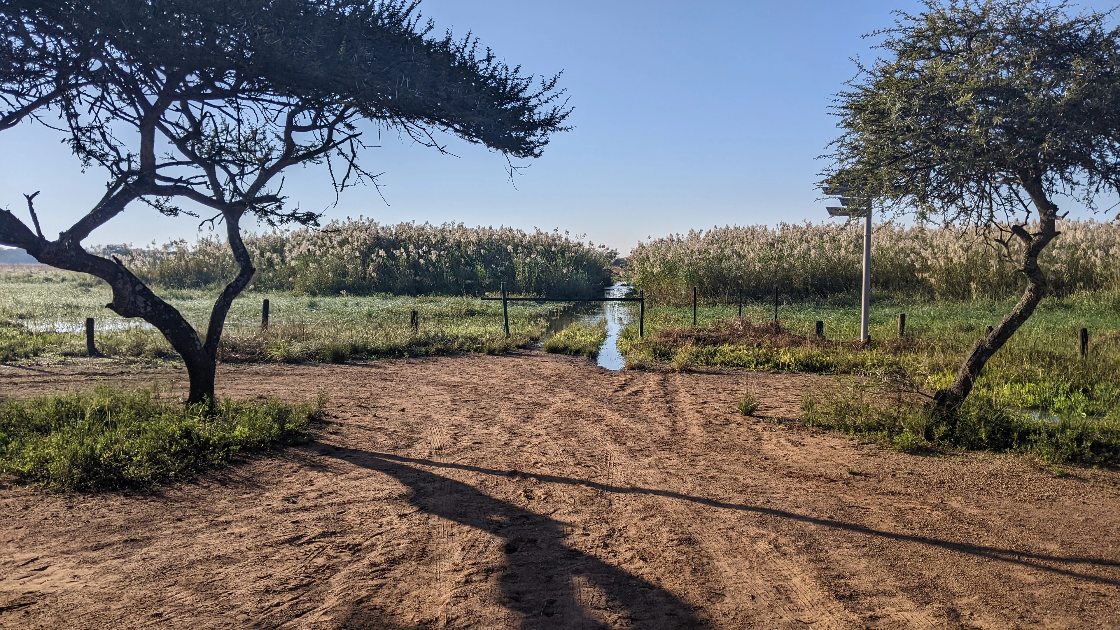
A dirt track leads towards a flooded area covered in tall reeds, framed by two large acacia trees under a clear sky.
A dirt path leading into the seasonally inundated floodplain at Nylsvley Nature Reserve.

Nylsvley Nature Reserve history and protected-area timeline

The name Nylsvley reflects the landscape itself, combining the Afrikaans word vlei, meaning a pan or seasonally flooded area, with a reference to the Nile. In the 1860s, a group of Voortrekker farmers, encountering a vast flooded plain with a river flowing northward, legendarily associated it with the great Nile River of Africa, and the name Nylrivier, or Nile River, took hold locally.

The modern history of the site began with its formal protected-area establishment on 7 July 1998, when Nylsvley was designated as an official nature reserve and simultaneously recognized as a Ramsar wetland site of international importance. The reserve is administered through the Limpopo Department of Economic Development, Environment and Tourism, and since that founding designation it has functioned as a key reference site for floodplain management and waterbird conservation in South Africa's interior.

Nylsvley Nature Reserve landscape and geographic character

The landscape of Nylsvley is defined by flatness and water. The Nyl River, the uppermost stretch of the Mogalakwena, has an extremely shallow gradient, which causes floodwaters to spread out across a broad plain rather than carving deep channels. The result is a wide, seasonally inundated floodplain fringed and broken by patches of reedbed and surrounded by open woodland on the slightly higher ground beyond.

During the flood season, the plain becomes a vast, shallow sheet of water interspersed with reedbeds and grassy hummocks. The reedbeds themselves form extensive stands of common reed (Phragmites australis), giving parts of the floodplain a tall, dense, marshy character. As the water withdraws, these same areas transition into moist grassveld and then into progressively drier conditions, before grading into the open woodland that surrounds the floodplain. This shifting mosaic of water, marsh, grassland, and savanna bushveld is the defining physical character of the reserve.

Nylsvley Nature Reserve ecosystems, habitats, and plant life

Nylsvley's ecological identity is built around the interaction between its floodplain and the surrounding bushveld. The wetland core, dominated by reedbeds and seasonally flooded grasslands, supports a dense and diverse aquatic and waterside community, while the open woodland on the better-drained margins adds a savanna ecological layer. This combination of wetland and bushveld habitats within a relatively small area produces a notably high level of habitat diversity.

The floodplain's hydrology is central to the reserve's ecology. Because the gradient is so shallow, even modest seasonal rainfall can produce extensive flooding, creating temporary habitat for waterfowl, waders, and other wetland-dependent species. As conditions dry, the same ground supports grassveld vegetation adapted to alternating wet and dry cycles. On the edges, open woodland transitions into the surrounding regional landscape, providing habitat for terrestrial species and connecting the wetland to the broader Limpopo bushveld environment.

Nylsvley Nature Reserve wildlife and species highlights

Wildlife is one of the strongest draws of Nylsvley, and the reserve's birdlife is its defining feature. More than 370 bird species have been recorded, including over 100 waterfowl species, and during peak flood conditions the floodplain can hold over 80,000 birds at once. This makes the reserve one of the most significant inland bird concentrations in South Africa, with seasonal aggregations of ducks, geese, herons, storks, waders, and other waterbirds drawn by the flooded conditions.

Beyond birds, the reserve supports mammal populations typical of the surrounding bushveld region. Roan antelope and tsessebe are among the notable larger species present, both of which are characteristic of well-managed bushveld conservation areas in the northern interior. The combination of wetland-supported birdlife and bushveld mammal fauna gives Nylsvley an unusually broad wildlife profile for a reserve of its size.

Nylsvley Nature Reserve conservation status and protection priorities

Nylsvley holds formal recognition as a Ramsar Wetland of International Importance, designated on 7 July 1998, the same date as the reserve's formal establishment. This designation places it within a global framework for the protection of wetlands and reflects the international standing of its floodplain habitat for migratory and resident waterbirds.

The conservation value of the reserve lies in the ecological integrity of its floodplain and in the diversity supported by the interaction between wetland and woodland. By maintaining the natural hydrology of the upper Nyl River, the reserve sustains the seasonal flooding pattern that drives its biodiversity, particularly its exceptional birdlife. The presence of the only known South African populations of wild rice further raises its botanical conservation significance.

Nylsvley Nature Reserve cultural meaning and human context

The cultural context of Nylsvley is closely tied to its evocative name. In the 1860s, Voortrekker settlers moving through the region encountered a wide, flooded plain with a river that flowed toward the north and, by legend, associated it with the Nile River. The resulting name, Nylrivier or Nile River, combined with the Afrikaans term vlei, a pan or seasonal wetland, gave rise to the name Nylsvley, which continues to define the site's identity today.

Top sights and standout views in Nylsvley Nature Reserve

Nylsvley's strongest points of distinction lie in the convergence of wetland, birdlife, and regional landscape. The reserve anchors one of South Africa's most important inland bird concentrations on a seasonal floodplain that supports more than 370 recorded bird species and tens of thousands of individual birds at flood peak. It also protects a unique botanical feature in the country's only known stands of wild rice.

Equally distinctive is the reserve's physical character: a vast, shallow, reed-filled floodplain transitioning into open bushveld woodland. This combination of habitats, compressed into a relatively small area and recognized internationally through Ramsar status, makes Nylsvley a compact but unusually rich conservation landscape in the Limpopo Province.

Best time to visit Nylsvley Nature Reserve

The character of a visit to Nylsvley is closely tied to the seasonal flooding cycle of the Nyl River. Peak flood conditions bring the floodplain alive with waterbirds, concentrating ducks, waders, herons, and other waterfowl into dense, visible flocks and at times producing aggregations in the tens of thousands. This is the period when the reserve's signature bird spectacle is most pronounced.

In drier months, the floodplain transitions to moist grasslands and eventually to drier grassveld and open woodland, with wildlife viewing shifting toward mammals such as roan antelope and tsessebe in the surrounding bushveld. Travellers interested in the reserve's defining bird concentrations will find the flood season the most rewarding period to visit.
Monthly climate preview

Long-term representative monthly averages for temperature and precipitation

Nylsvley Nature Reserve Climate Normals and Annual Temperature Patterns

Nylsvley Nature Reserve exhibits a measured annual temperature and precipitation rhythm across its representative coordinate point from 1991 to 2020. Examining the complete twelve-month climate profile reveals deeper monthly variations in average minimums, maximums, and daily precipitation levels.
Annual mean20 °C
13 °C24 °C
Jan24°
Feb24°
Mar23°
Apr20°
May17°
Jun13°
Jul13°
Aug16°
Sep21°
Oct23°
Nov24°
Dec24°
Warmest month
January

24.5 °C

Coolest month
July

13.1 °C

Wettest month
December

2.9 mm/day

Driest month
July

0.1 mm/day

Park location guide

Geography guide, regional context, and park location map for Nylsvley Nature Reserve

Nylsvley Nature Reserve park geography, regions, and map view in South Africa

Understand where Nylsvley Nature Reserve sits in South Africa through a broader geographic reading of the surrounding landscape, nearby location context, and its mapped position within the national park landscape.

How Nylsvley Nature Reserve fits into South Africa

South Africa is the southernmost country in Africa, spanning 1.22 million km² with a population of over 63 million. The country operates with three capital cities, Pretoria (executive), Cape Town (legislative), and Bloemfontein (judicial), and is renowned for its biodiversity, national parks, and multicultural society.

Wider geography shaping Nylsvley Nature Reserve in South Africa

South Africa occupies the southernmost region of Africa, with coastline along both the Atlantic Ocean to the west and the Indian Ocean to the east. The interior features elevated plateaus including the Highveld, with the Drakensberg escarpment marking the eastern highlands. The country shares borders with Namibia, Botswana, Zimbabwe, Mozambique, Eswatini, and Lesotho.

Map view of Nylsvley Nature Reserve

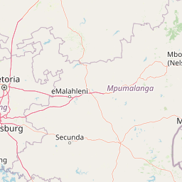
Use this park location map to pinpoint Nylsvley Nature Reserve in South Africa, understand its exact geographic position, and read its mapped placement within the surrounding landscape more clearly.

Pigeon | © OpenStreetMap contributors

Location context for Nylsvley Nature Reserve

Limpopo Province
Recorded earthquake history

Examine the Recorded Earthquake History of Nylsvley Nature Reserve

Review the historical catalogue of earthquakes associated with the proximity of Nylsvley Nature Reserve. This data provides an accessible, structured look at recorded seismic events documented in the vicinity of this Ramsar wetland area, allowing for a factual understanding of regional activity.

Nylsvley Nature Reserve Earthquake History

Catalogued events

1 event

Strongest magnitude

Magnitude 4.8

Most recent event

Dec 2, 2013

This history includes earthquakes recorded inside the park or within 50 km of its borders

Visualizing floodplain habitats and protected wetland terrain

Nylsvley Nature Reserve Photos and Landscape Scenery

Visual documentation reveals the seasonal floodplains, dense reedbeds, and open bushveld woodland defining Nylsvley Nature Reserve. Studying these protected area views clarifies the unique wetland hydrology and diverse natural habitats characteristic of the region.

A dirt track leads towards a flooded area covered in tall reeds, framed by two large acacia trees under a clear sky.

Park atlas

Compare adjacent wetland habitats, regional bushveld reserves, and connected conservation landscapes.

Exploring Parks Near Nylsvley Nature Reserve and Surrounding Protected Areas

Browse other protected areas near Nylsvley Nature Reserve to examine similar floodplain ecologies and regional bushveld habitats. Continuing into surrounding national parks and reserves provides broader geographic context for South African conservation landscapes.
Biosphere reserveLimpopo
34 km away#1 closest

Northwest

Waterberg Biosphere: A Protected Sandstone Massif in Limpopo Province South Africa

Geology, mapping, and ecological zones of the Waterberg range

The Waterberg Biosphere stands as a major protected region in South Africa, formed by ancient sandstone layers sculpted into mesas and deep gorges. This massif bridges ecological zones from highland savanna to riverine habitats, anchoring a network of game reserves and wilderness areas through its distinctive geological and historical landscape identity.

Area
6,540.33 km²
Established
2001
Relief
Mountain
Climate
Subtropical
Nature reserveLimpopo
About 66 km away#2 closest

West

Mabalingwe Nature Reserve: Protected Bushveld Geography and Terrain Analysis

Mapping the Limpopo reserve landscape and habitat features

Examine the 8,800-hectare landscape of Mabalingwe Nature Reserve. From its malaria-free bushveld habitat to its network of seasonal dams and mixed woodland terrain, this entry provides a clear look at the environmental context of this private Limpopo protected area.

Area
88 km²
Established
1989
Relief
Upland
Climate
Subtropical
Wildlife reserveLimpopo
About 76 km away#3 closest

West

Mabula Game Reserve: Protected Bushveld and Geographic Landscape Profile

Exploration of the Limpopo bushveld and wildlife habitat boundaries

Mabula Game Reserve provides a detailed look at the bushveld ecosystems of South Africa. Spanning 12,000 hectares in Limpopo, the reserve features a unique blend of rocky ridges, open savanna, and riverine woodlands. Its structural diversity creates a distinct natural corridor that serves as a focal point for understanding regional wildlife distribution and the transition zone between the Waterberg and the northern plains.

Area
120 km²
Scope
Terrestrial
Wildlife reserveLimpopo
About 90 km away#4 closest

Northwest

Welgevonden Game Reserve: A Comprehensive Geographic Profile of a Limpopo Wildlife Haven

Mapped terrain across the Waterberg mountain bushveld

Welgevonden Game Reserve stands as a focal point for protected land discovery in South Africa. The reserve features complex geological formations, ranging from steep cliffs to open plateau grasslands. Gain insights into the physical boundaries and landscape diversity that define this significant conservation area located within the northern Limpopo province.

Area
382 km²
Relief
Mountain
Access
Access unknown
Scope
Terrestrial
A soft watercolor painting of a river flowing through a hilly, green valley with distant ridgelines under a pale sky.
Nature reserveLimpopo
About 91 km away#5 closest

North

Lapalala Wilderness Nature Reserve: Geographic Atlas and Park Landscape Mapping

Protected bushveld terrain in the Limpopo province of South Africa

Lapalala Wilderness represents an influential private conservation landscape featuring over forty-eight thousand hectares of bushveld habitat. Gain insight into the reserve's structural diversity, including its sixty kilometers of priority river systems and distinct land types that define this protected territory in Limpopo.

Area
480 km²
Established
1981
Relief
Upland
Climate
Subtropical
National parkLimpopo Province
92 km away#6 closest

West

Marakele National Park: National Park Protected Landscape and Geographic Context

Explore its Limpopo Province regional setting and mapped boundaries.

Marakele National Park represents a vital protected national park within the diverse geography of Limpopo Province, South Africa. This entry provides detailed atlas-style information on its protected landscape, focusing on mapped geographic boundaries and its context within the regional natural terrain. It serves as a key resource for understanding the park's specific role as a conservation area and its place within the broader atlas of South African protected lands.

Area
670 km²
Established
1994
Relief
Mountain
Climate
Subtropical
Wildlife reserveNorth West Province
About 101 km away#7 closest

Southwest

Borakalalo Game Reserve: Protected Bushveld and Aquatic Landscapes in North West Province

Mapping a diverse South African wildlife reserve

Borakalalo Game Reserve features a distinct ecological setting within South Africa, combining woodland bushveld with the aquatic ecosystems of Klipvoor Dam. This protected area provides a habitat for varied mammal species and an extensive bird list, set against the backdrop of the interior plateau landscape in North West Province.

Area
130 km²
Relief
Upland
Access
Access unknown
Scope
Terrestrial
Wildlife reserveLimpopo
About 105 km away#8 closest

Northeast

Polokwane Game Reserve: A Comprehensive Geographic Profile of a Limpopo Wildlife Reserve

Mapped boundaries and natural habitat in northern South Africa

Spanning 2,800 hectares of grassy plains and bushveld, Polokwane Game Reserve serves as a critical municipal protected area near the urban core of Polokwane. This geographic overview highlights the reserve's unique eastern ridge flora, its chain of riverine waterholes, and the spatial distribution of its protected landscape within the Limpopo province.

Area
28 km²
Established
1977
Relief
Upland
Climate
Subtropical

Common questions about visiting, size, designation, and location context for Nylsvley Nature Reserve

Nylsvley Nature Reserve FAQs for park facts, access, geography, and protected area context

Find quick answers about Nylsvley Nature Reserve, including protected-area facts, park geography, trail and visitor context, and how the park fits into its surrounding country and regional landscape.
MoriAtlas Explorer

Continue Your Protected Areas Search Across the Global Atlas

Deepen your exploration by continuing the structured search for national parks and protected areas worldwide. Utilize the comprehensive filtering capabilities to compare different conservation landscapes and refine your understanding of global park geography. Discover more about the distribution and characteristics of protected natural areas.

Global natural geography