
Mori Atlas logo
Protected landscapeObersäckingen

Mapping the traditional mosaic of southern Black Forest meadows, woodlands, and hedgerows

Obersäckingen Protected Landscape and Regional Geography within Baden-Württemberg Germany

(Landschaftsschutzgebiet „Obersäckingen“)

Obersäckingen represents a distinctive protected landscape covering 41.5 hectares of rolling low-mountain countryside in the Waldshut district. This reserve preserves a traditional rural mosaic where woodland patches, small field copses, and colorful oat-grass meadows create an ecologically significant habitat linked to the broader Murg zum Hochrhein Natura 2000 network. Its geography offers a clear look at the diverse, agrarian-influenced terrain characteristic of the southern Black Forest region.

protected landscapeBlack Forestsouthern Black Forestmeadow landscapeGlatthaferwiesenmixed woodland
A graphic illustration depicting a valley between steep, stylized mountains with a waterfall cascading into a winding river, all surrounded by evergreen trees.

Obersäckingen

Protected landscape

Park overview

Structured park overview, official facts, and landscape profile for Obersäckingen Protected Landscape

Obersäckingen Protected Landscape park facts, protected area profile, and essential visitor context

Review the core facts for Obersäckingen Protected Landscape, including designation, size, terrain, visitor scale, habitats, and operating context in one park-focused overview.

About Obersäckingen Protected Landscape

Obersäckingen is a small protected landscape reserve in the Waldshut district of Baden-Württemberg, positioned in the southern reaches of the Black Forest near the High Rhine. Although modest in size, the reserve has been formally protected since early 2004 through a designation by the Waldshut district office, recognizing both its ecological value and its role for local outdoor recreation.

Geographically, the reserve lies northeast of the village of Obersäckingen, which is part of the town of Bad Säckingen. It lies within the southern Black Forest natural area of the larger Black Forest region and inside the broader Naturpark Südschwarzwald, an area known for its mix of forested hills, valley landscapes, and traditional agricultural countryside.

Ecologically, almost the entire protection area falls within the FFH site "Murg zum Hochrhein" (habitat site number 8413-341), giving the landscape protection area an important role in safeguarding habitat continuity at a regional scale. The reserve's protected purpose combines the conservation of a traditional mixed countryside with the preservation of valuable open habitats, especially species-rich meadows of conservation importance.

Quick facts and research context for Obersäckingen Protected Landscape

Obersäckingen is a state-recognized protected landscape (Landschaftsschutzgebiet) covering about 41.5 hectares. It is administered by the Waldshut district office (Landratsamt Waldshut) and is identified in German conservation records under the code 3.37.011 and in the World Database on Protected Areas under WDPA ID 378653. The reserve sits within the natural region of the Southern Black Forest (Naturpark Südschwarzwald) and overlaps almost entirely with the FFH site "Murg zum Hochrhein."

Protection and recognition

Examine documented protected area designation facts and international recognition data.

Obersäckingen Protection Status and International Recognition Records

Obersäckingen protection status records outline official designation frameworks and management scope. Verified database entries provide structured context for international recognition tracking.

Protection details

WDPA ID
378653
Park context

Deeper park guide and search-rich context for Obersäckingen Protected Landscape

Obersäckingen Protected Landscape history, landscape, wildlife, and travel context

Explore Obersäckingen Protected Landscape through its history, landscape character, ecosystems, wildlife, conservation priorities, cultural context, and seasonal travel timing in a structured park guide built for atlas discovery and search intent.

Why Obersäckingen Protected Landscape stands out

Obersäckingen is especially known for preserving a finely balanced mosaic of woodland, hedgerows, field copses, and broad open grassland, including colorful species-rich oat-grass meadows (Glatthaferwiesen) that are characteristic of the southern Black Forest. The reserve is also notable for closely overlapping with the larger "Murg zum Hochrhein" Natura 2000 site, giving it clear ecological value beyond its modest size.
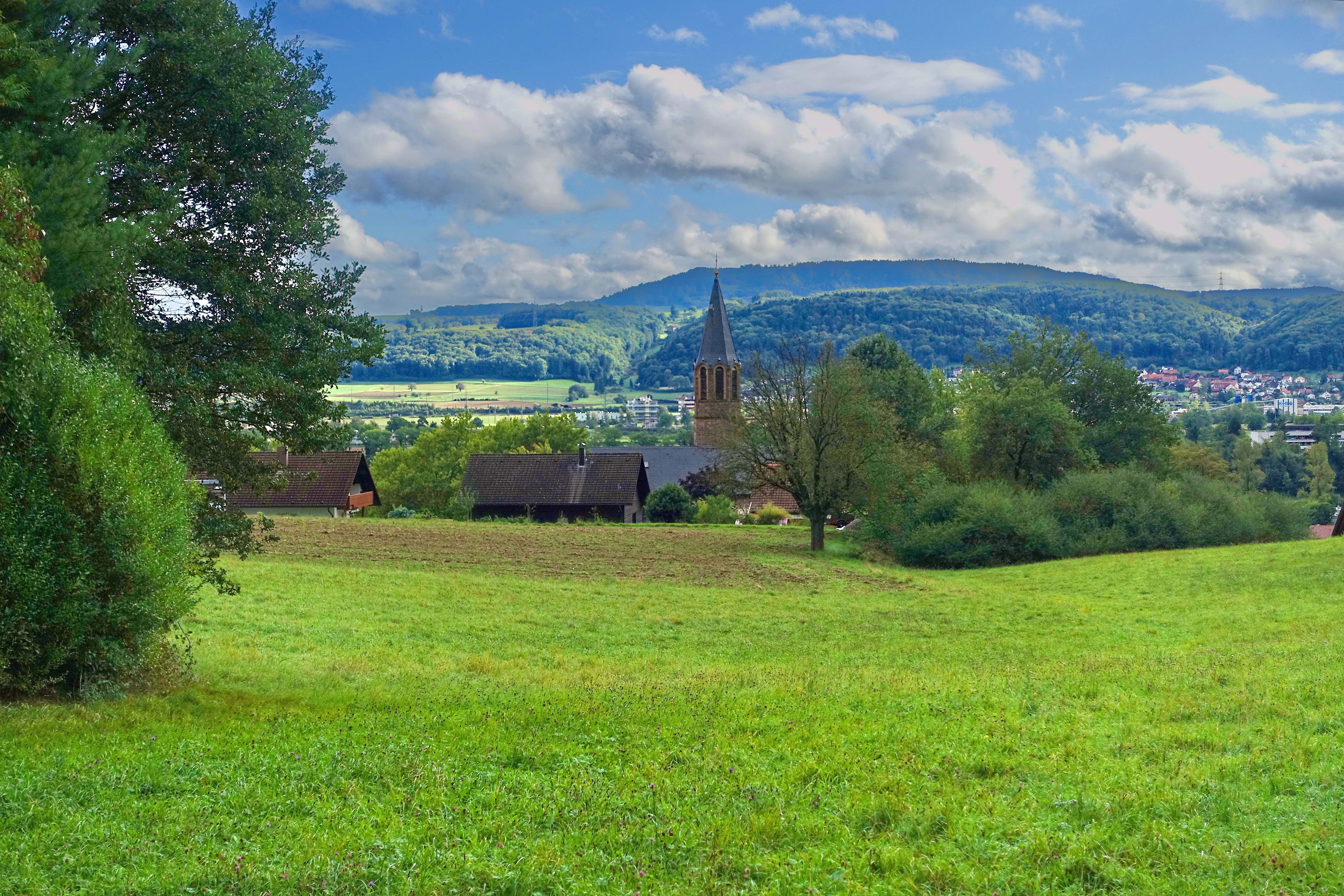
A green, rolling meadow in the foreground leads to a small group of farmhouses and a tall, slender church tower; rolling, tree-covered mountains rise in the background under a blue sky with scattered clouds.
A scenic view over the Obersäckingen landscape protection area, showing a blend of green meadows, small farm buildings, and a distant church spire nestled against forested hills.

Obersäckingen Protected Landscape history and protected-area timeline

The Obersäckingen protected landscape was formally established by decree of the Waldshut district office (Landratsamt Waldshut) on 20 January 2004. The designation recognized the area's combination of natural beauty, ecological value, and recreational importance for the local population.

The creation of the reserve built on the area's existing classification within the Natura 2000 network through the overlapping FFH site "Murg zum Hochrhein," which was already anchored in European habitat protection frameworks. The 2004 designation extended and complemented this by formally protecting the broader landscape mosaic around the conservation-relevant open habitats.

Obersäckingen Protected Landscape landscape and geographic character

The protected landscape is set in the southern Black Forest, near the broad High Rhine valley. The terrain is typical of this part of Baden-Württemberg: gently rolling low-mountain countryside shaped by forested ridges, small valleys, and traditional agricultural areas.

Within the reserve, the scenery is defined by the alternation of woodland, scattered field copses, hedgerows, and large patches of open grassland. Species-rich, colorful oat-grass meadows form one of the most distinctive visual features, creating open flower-rich stretches within the otherwise wooded landscape. This mosaic gives the area much of its scenic character and ecological value.

Obersäckingen Protected Landscape ecosystems, habitats, and plant life

The ecological identity of Obersäckingen lies in its mix of habitat types. Closed woodland sections, field copses, and hedgerows alternate with open grassland, producing a finely structured landscape mosaic that supports both forest-dwelling and open-country species.

A particularly important habitat element is the presence of low-intensity hay meadows, especially species-rich Glatthaferwiesen (oat-grass meadows) and other lowland hay meadows that belong to the conservation priorities of the overlapping FFH site. Because of this overlap, much of the reserve contributes to the maintenance and protection of habitat types and ecological structures of the broader Murg zum Hochrhein area.

Obersäckingen Protected Landscape wildlife and species highlights

The reserve does not function primarily as a wildlife-viewing destination, and the available source material does not provide detailed species inventories. Nevertheless, the combined presence of woodland, hedgerows, and flower-rich meadows creates suitable conditions for insects and pollinators associated with traditional hay meadows, as well as for small mammals and typical Black Forest forest species that depend on edge habitats and mixed countryside.

Obersäckingen Protected Landscape conservation status and protection priorities

The core conservation purpose of Obersäckingen is the preservation of a diverse, near-natural countryside that combines woodland, hedgerows, field copses, and open meadows. The reserve protects the area's natural character, scenic value, and its function as a local recreation space.

On a broader scale, the protection area plays a supporting role for the Natura 2000 network: nearly all of it lies within the FFH site "Murg zum Hochrhein." This overlap gives the reserve particular importance for safeguarding habitat types such as species-rich lowland hay meadows, and helps maintain ecological continuity in the southern Black Forest and High Rhine transition zone.

Top sights and standout views in Obersäckingen Protected Landscape

Obersäckingen stands out for the way it preserves a traditional southern Black Forest landscape pattern: small woodlands, hedgerows, and field copses woven together with broad, flower-rich meadows. This mosaic, combined with the reserve's nearly complete overlap with the "Murg zum Hochrhein" nature protection site, makes it a small but ecologically meaningful piece of the regional conservation network in the Waldshut district.

Best time to visit Obersäckingen Protected Landscape

As a small low-mountain landscape reserve, Obersäckingen can be appreciated year-round, but late spring and early summer are generally the most rewarding times to experience it. During this period the species-rich meadows typically come into bloom, bringing out the flower-rich character of the Glatthaferwiesen that are central to the landscape. Late summer offers attractive contrasts between ripening grasslands and surrounding woodlands, while quieter autumn and winter visits emphasize the mosaic structure of forest, hedgerows, and open fields.

Monthly climate preview

Long-term monthly temperature averages and precipitation measurements for Obersäckingen

Obersäckingen Climate Normals, Annual Temperature and Precipitation Profiles

Representative coordinate data records measured annual temperature ranges alongside consistent monthly precipitation patterns for Obersäckingen. Examining the full twelve-month profile provides complete historical averages for detailed climate analysis.
Annual mean9 °C
-1 °C18 °C
Jan-1°
Feb
Mar
Apr
May13°
Jun17°
Jul18°
Aug18°
Sep14°
Oct
Nov
Dec
Warmest month
July

18.3 °C

Coolest month
January

-0.6 °C

Wettest month
May

4 mm/day

Driest month
February

2.3 mm/day

Park location guide

Geography guide, regional context, and park location map for Obersäckingen Protected Landscape

Obersäckingen Protected Landscape park geography, regions, and map view in Germany

Understand where Obersäckingen Protected Landscape sits in Germany through a broader geographic reading of the surrounding landscape, nearby location context, and its mapped position within the national park landscape.

How Obersäckingen Protected Landscape fits into Germany

Germany is a federal republic in Western and Central Europe with a population of over 83 million across sixteen constituent states. It is Europe's largest economy by nominal GDP and a major global exporter and importer. The capital is Berlin, and the country borders Denmark, Poland, Czech Republic, Austria, Switzerland, France, Luxembourg, Belgium, and the Netherlands.

Wider geography shaping Obersäckingen Protected Landscape in Germany

Germany is located in Western and Central Europe, spanning 357,022 km². It borders Denmark to the north, Poland and the Czech Republic to the east, Austria and Switzerland to the south, and France, Luxembourg, Belgium, and the Netherlands to the west. The country has coastlines on the Baltic Sea and North Sea to the north, with the Alps located in the southern region.

Map view of Obersäckingen Protected Landscape

Use this park location map to pinpoint Obersäckingen Protected Landscape in Germany, understand its exact geographic position, and read its mapped placement within the surrounding landscape more clearly.

Pigeon | © OpenStreetMap contributors

Location context for Obersäckingen Protected Landscape

Baden-Württemberg

Visualizing the mixed woodland and flower-rich meadows of the southern Black Forest

Obersäckingen Landscape Photos and Protected Area Scenery

Visual documentation reveals the intricate mosaic of woodland, hedgerows, and species-rich oat-grass meadows defining the protected landscape. Examining these field copses and rolling low-mountain terrain provides clear insight into the conservation character of the southern Black Forest region.

A green, rolling meadow in the foreground leads to a small group of farmhouses and a tall, slender church tower; rolling, tree-covered mountains rise in the background under a blue sky with scattered clouds.

Park atlas

Compare adjacent low mountain reserves and regional conservation areas in the southern Black Forest

Explore Other Parks Near Obersäckingen and Surrounding Protected Landscapes

Browse protected areas near Obersäckingen to discover similar meadow mosaics and forested ridges across the Waldshut district. Expanding the regional park comparison reveals wider conservation patterns throughout the surrounding Baden Württemberg countryside.
Protected landscapeBaden-Württemberg
About 9 km away#1 closest

Northwest

Südwestlicher Dinkelberg Protected Landscape and Dinkelberg Plateau Geography

Karst terrain and forest habitats in Baden-Württemberg

Located in the Lörrach district, Südwestlicher Dinkelberg protects a diverse mix of ravine forests, dry grasslands, and mires. The area preserves essential ecological corridors within the Lörrach-Basel region, showcasing complex geological features such as stream sinks and dry valleys that define the plateau edge.

Area
13.89 km²
Established
2013
IUCN
V
Relief
Upland
A watercolor painting showing a panoramic view of green rolling hills and wooded ridges under a soft light.
Regional parkAargau
About 13 km away#2 closest

Southeast

Jurapark Aargau: Geographic Overview of a Swiss Regional Nature Park and Jura Landscapes

Protected Jura mountain terrain and regional landscape mapping

Located in northern Switzerland, Jurapark Aargau encompasses a vast, connected perimeter defined by the interaction of tabular limestone plateaus and dramatic folded mountain ridges. This regional nature park serves as an essential refugium for native flora, preserving ancient geological history through fossil-rich sediments, steep escarpments, and traditional rural land use that persists between the Aargau, Zurich, and Basel regions.

Area
299 km²
Established
2012
Relief
Mountain
Climate
Temperate
A horizontal watercolor painting depicting a landscape with soft rolling hills, green meadows, and wild grasses under a pale sky.
Nature reserveBaden-Württemberg
About 14 km away#3 closest

Northwest

Dinkelberg und Röttler Wald: Geographic Overview of this Baden-Württemberg Nature Reserve

Protected karst landscapes and mature beech forest habitat

Uncover the ecological and physical geography of Dinkelberg und Röttler Wald, a protected area stretching across diverse limestone plateaus and sandstone slopes in Germany. This site offers a valuable look at managed cultural landscapes that bridge the gap between rural meadows and wild forest reserves, providing critical habitat for European bat populations and rare flora across its varied elevational zones.

Area
46.47 km²
Established
2015
Nature reserveAargau
About 18 km away#4 closest

East

Klingnauer Stausee Nature Reserve: Aargau Wetland and Aare River Floodplain Landscapes

Protected riparian habitat in the northern Swiss Jura

Klingnauer Stausee stands as a primary example of integrated hydropower and conservation. This artificial reservoir and its surrounding wetlands, located in the Aargau region, encompass a variety of protected habitats ranging from open still waters to alluvial forests. These landscapes provide essential refuge for migratory waterbirds and preserve unique remnants of the historical Aare River floodplain structure.

Area
1.16 km²
Established
1935
Relief
Lowland
Climate
Temperate
Watercolor painting of a river landscape with lush green riverbanks, patches of grass in the foreground, and gentle rolling hills in the background.
Protected landscapeAargau
About 20 km away#5 closest

East

Aarelandschaft bei Klingnau: A Protected Riverine Landscape in Northern Switzerland

Wetland geography, alluvial forests, and floodplain corridors

The Aarelandschaft bei Klingnau preserves a unique riverine mosaic where the Aare River meets the Rhine in northern Aargau. This protected landscape encompasses the Klingnauer Stausee reservoir, rich alluvial forests, and remnant oxbows. It serves as a vital migratory node for avian populations and provides a structured look at the interplay between human-engineered power infrastructure and protected natural river channels.

Area
3.6 km²
Established
1996
IUCN
V
Relief
Lowland
A soft watercolor illustration of rolling hills, forested slopes, and meadow vegetation with a light, airy aesthetic.
Nature reserveBaden-Württemberg
About 25 km away#6 closest

North

Belchen Nature Reserve: Exploring the Mountain Geography of the High Black Forest

A diverse protected landscape in Baden-Württemberg

Belchen represents an essential protected area in the southern Black Forest, known for its compressed ecological profile ranging from lowland beech forests to exposed subalpine summits. The site maps a complex mosaic of scree slopes, mires, and rocky habitats that sustain specialized bat species and rare montane flora, offering a detailed perspective on central European highland ecosystems.

Area
29.072 km²
Established
2019
Relief
Mountain
Climate
Temperate
Watercolor painting of a pastoral landscape featuring soft, rolling green hills and a small group of evergreen trees, with light pastel mountains in the background.
Protected landscapeBaden-Württemberg
About 27 km away#7 closest

Northeast

St. Blasien Protected Landscape: Geographic Profile and Glacial Mapping

Southern Black Forest protected area in Baden-Württemberg.

The St. Blasien Protected Landscape represents a significant conservation zone in the southern Black Forest. Defined by its strong glacial influence, the area showcases a complex terrain of trough valleys, moraine ridges, and rocky crests alongside centuries-old alpine pastures. Its role in the regional conservation network makes it a key site for understanding the intersection of Pleistocene geography and traditional land management in Germany.

Area
35.754 km²
Established
2002
IUCN
V
Nature reserveBaden-Württemberg
About 32 km away#8 closest

Northeast

Blumberger Pforte und Mittlere Wutach: Protected Landscape and Gorge Geography

Nature reserve terrain and ecological atlas in Baden-Württemberg

This protected area captures the dramatic transition where the Wutach river cuts through limestone strata. Discover a rugged landscape mosaic featuring canyon forests, juniper heaths, and karst cave systems across the Swabian Alb and Black Forest fringe. The site offers significant value for understanding regional ecological gradients and limestone-dependent plant communities within the broader southern German geography.

Area
63.25 km²
Established
2019

Common questions about visiting, size, designation, and location context for Obersäckingen Protected Landscape

Obersäckingen Protected Landscape FAQs for park facts, access, geography, and protected area context

Find quick answers about Obersäckingen Protected Landscape, including protected-area facts, park geography, trail and visitor context, and how the park fits into its surrounding country and regional landscape.
MoriAtlas Explorer

Continue Your Protected Areas Search Across the Global Atlas

Deepen your exploration by continuing the structured search for national parks and protected areas worldwide. Utilize the comprehensive filtering capabilities to compare different conservation landscapes and refine your understanding of global park geography. Discover more about the distribution and characteristics of protected natural areas.

Global natural geography