
Mori Atlas logo
Nature reserveÖchsenberg

An atlas exploration of basalt domes, scree forests, and prehistoric hilltop settlements within Thuringian geography.

Öchsenberg Nature Reserve: Mapping the Volcanic Terrain and Celtic History of the Northern Rhön

(Naturschutzgebiet Öchsenberg)

Rising prominently above the Werra valley, Öchsenberg serves as a distinct northern anchor for the Rhön highlands. This protected nature reserve preserves the remains of a Tertiary-era volcanic dome, where steep slopes and dense beech forests create a unique landscape of scree and basalt blocks. Beyond its natural geography, the summit contains traces of one of the largest Celtic hillforts in Thuringia, grounding the site in both geological time and human history.

volcanic landscapebasalt domeRhön highlandsbeech forestscree woodlandCeltic hillfort
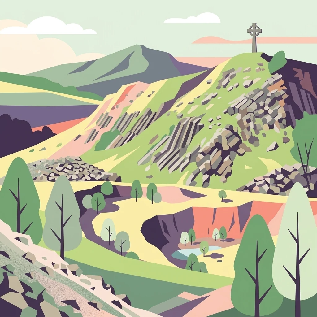
A stylized digital illustration of a mountainous landscape with rocky slopes, trees, a valley, and a cross standing on the peak of the mountain.

Öchsenberg

Nature reserve

Park overview

Structured park overview, official facts, and landscape profile for Öchsenberg

Öchsenberg park facts, protected area profile, and essential visitor context

Review the core facts for Öchsenberg, including designation, size, terrain, visitor scale, habitats, and operating context in one park-focused overview.

About Öchsenberg

Öchsenberg is a forested volcanic peak in the northern Rhön, in the German state of Thuringia. It rises roughly 627 meters above sea level and dominates the landscape south of the town of Vacha, overlooking the valley of the Werra river. As one of the most northerly summits of the Rhön range, it marks an important transition between the open highlands of the central Rhön and the more settled, agriculturally used countryside toward the Werra.

The mountain belongs to the classic family of basalt domes, or Basaltkuppen, that give the northern Rhön much of its distinctive relief. Its current shape is the result of long geological history rather than a complete volcanic edifice. During the Miocene, volcanic eruptions produced basaltic and tuffaceous rocks in what was then a nearly flat landscape. Over the following millions of years, the softer surrounding sediments were eroded, leaving only the resistant remnants of the volcanic vent exposed. This hard core, called a Schlotfüllung, now forms the summit block, while the deeper geological context consists of Muschelkalk limestones and claystones of the Röt formation.

Above the geological story sits another layer of significance. The summit and upper flanks of the Öchsenberg were already inhabited thousands of years ago. Archaeological work beginning in the 1950s traced continuous use from the Neolithic, through the Urnfield period and Bronze Age burial mounds, into a major Late Hallstatt and Middle La Tène hillfort. The Celtic oppidum covered about 30 hectares across the summit area, surrounded by multiple ring walls of basalt blocks. Today, sections of these walls remain visible, especially in the southern and southwestern parts of the mountain where quarrying never reached.

In the 19th and 20th centuries, industrial basalt quarrying reshaped the mountain once again. Beginning in the late 19th century and intensifying during the GDR era, extraction stripped large parts of the summit and lowered the peak by roughly 16 meters. A pavilion, a Bismarck tower, and various shelters rose and fell in this period, and the mountain became inaccessible to the public for decades. After German reunification, conservation efforts and citizen protests ended quarrying, and in 1990 the area was designated as a nature reserve within the UNESCO Rhön Biosphere Reserve.

Today the Öchsenberg is once again a hiking peak, crossed by regional trails such as the Main-Werra, Wasserkuppe-Bad Salzungen, and Ulstertalweg routes. Its slopes are covered with extensive beech forest and scree woodland, the summit features a Celtic cross marking the historical significance of the site, and a small hiking hut provides visitor information. The mountain has reclaimed its role as a focal point of the northern Rhön landscape.

Quick facts and research context for Öchsenberg

Öchsenberg is located in the Wartburgkreis district of Thuringia, Germany, just south of the Werra river and the town of Vacha. It is one of the northernmost basalt domes of the Rhön highlands, with a summit elevation of approximately 627 meters.

Geologically, the peak is the eroded core of an extinct Miocene volcano, composed of a basaltic rock first described as limburgite. Its slopes rise above Muschelkalk limestones and Röt claystones, which were worn down around the harder volcanic plug.

The mountain has been a nature reserve since 1990, covering about 267 hectares, and forms part of the UNESCO Rhön Biosphere Reserve. It also preserves the remains of a roughly 30-hectare Late Hallstatt to Middle La Tène Celtic oppidum.

Protection and recognition

Analysis of terrestrial conservation history and official designation records for Öchsenberg

Öchsenberg Protection Status and Protected Area Designation Details

Terrestrial protection records trace the conservation history and established designation timeline for Öchsenberg starting from nineteen ninety. Structured designation data clarifies the documented management scope without relying on external recognition frameworks or unverified administrative claims.

Protection details

Protection scope
Terrestrial
Designated year
1990
Transboundary protection
No
Park context

Deeper park guide and search-rich context for Öchsenberg

Öchsenberg history, landscape, wildlife, and travel context

Explore Öchsenberg through its history, landscape character, ecosystems, wildlife, conservation priorities, cultural context, and seasonal travel timing in a structured park guide built for atlas discovery and search intent.

Why Öchsenberg stands out

Öchsenberg is best known as one of the northernmost basalt domes of the Rhön mountains and as the site of a major Late Hallstatt and La Tène Celtic hillfort on its summit. The combination of volcanic geology, dense beech forest, and prehistoric wall remnants gives the peak a layered identity that is unusual for mountains in this part of Germany. The mountain is also known for its long history of basalt quarrying, which dramatically reshaped its summit in the 20th century, and for its later transformation into a protected landscape within the Rhön Biosphere Reserve.
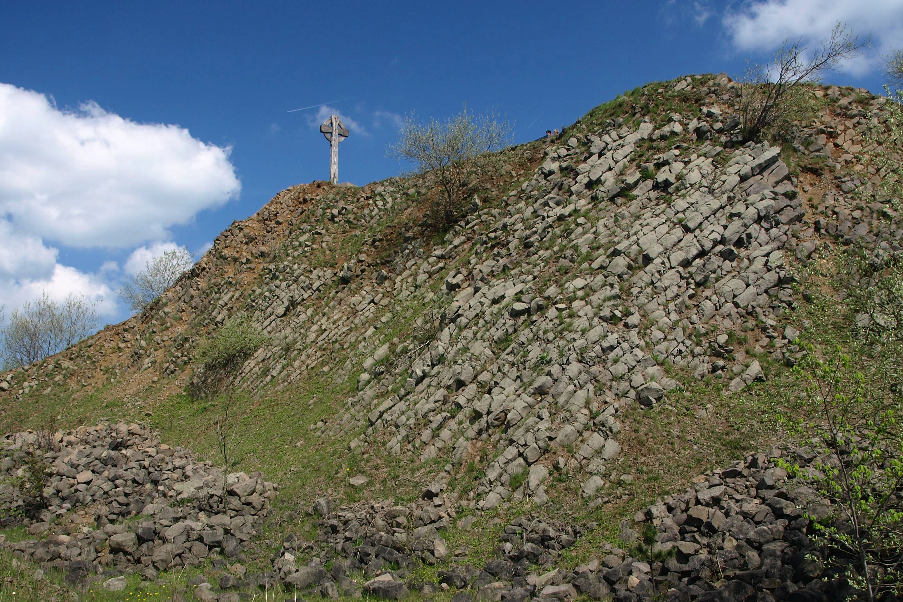
A sunny view of a steep, rocky basalt hillside with a wooden cross at the summit against a blue sky.
A wooden Celtic-style cross stands atop the basalt mountain of Öchsenberg.

Öchsenberg history and protected-area timeline

The history of the Öchsenberg stretches back thousands of years. Archaeological surveys conducted between 1959 and the early 1970s documented human presence on the mountain from the Neolithic period onward, with urn burial remains and Bronze Age tumuli on the slopes. The most important phase, however, was the Iron Age, when a large Celtic oppidum extended across the entire summit plateau, enclosed by double and sometimes triple ring walls of basalt.

The settlement is interpreted as a strategic bridgehead of the Antsanvia, an ancient road connecting the Rhine-Main region with the Thuringian Basin via a Werra crossing, and is regarded as one of the largest hilltop fortifications in Thuringia alongside the Steinsburg near Römhild. Some researchers suggest that the Öchsenberg may correspond to the Kandouon mountain recorded by the geographer Claudius Ptolemy. The first clear documentary reference appears in 786, in a deed of donation by Charlemagne, where the mountain is named Uhsineberga.

Tourist use of the summit began in the 19th century. In 1876, the Grand Ducal Saxon chief forester Richard Schmidt erected a twelve-sided wooden pavilion with a viewing platform, after an earlier shelter had been destroyed by a storm. Schmidt also founded the Vacha section of the Rhön Club in 1877, which then marked the first hiking trails on the still higher pre-quarry summit. Around 1900 the pavilion fell into disrepair, leading to the construction of a three-story Bismarck tower, completed in 1907, and a new timber shelter. The tower and hut survived the First World War but deteriorated during the era of industrial basalt extraction.

Quarrying has shaped the mountain since at least the 17th century, intensifying around the turn of the 20th century. From 1899 to 1975 a cable ropeway connected the basalt works to the Vacha railway station, and after 1945 the GDR enterprise VEB Rhönbasalt raised production dramatically, reaching 6,000 wagons per year by 1986. The mining operations reduced the summit by about 16 meters, and after the upper slopes had been declared military and industrial exclusion zones, the mountain was inaccessible to the public.

After 1990, the reconstituted Rhön Club Vacha reopened and remarkmarked hiking trails on the Öchsenberg. A citizen initiative prevented any resumption of quarrying, and the area was placed under nature protection within the Rhön Biosphere Reserve. The mountain has since been reintegrated into the regional hiking network, with a new hiking hut and information point standing close to a Celtic cross on the present-day summit.

Öchsenberg landscape and geographic character

The Öchsenberg rises above the broad valley of the Werra, about three kilometers south of Vacha. Its silhouette is a compact, dome-shaped peak framed by the Oechse river to the north and east and by the Sünna stream to the west, giving the mountain a clearly defined, isolated position within the northern Rhön foothills.

To the south, a saddle of about 450 meters elevation connects the Öchsenberg with its higher neighbor, the Dietrichsberg, while the lesser Hahnkopf extends along the southeastern slope. Villages such as Sünna and the smaller hamlet of Poppenberg lie on the lower flanks. Below roughly 360 meters the slopes are largely agricultural; above this line the terrain gives way to extensive forest.

The most distinctive feature of the mountain's surface is its basaltic summit core. Slopes of rounded basalt blocks cover parts of the upper mountain and partly obscure the underlying rocks. Where blocks have accumulated into block fields and scree, they anchor a distinctive forest and rock habitat distinct from the smoother limestone surroundings. The combination of steep upper slopes, rocky basalt debris, beech woodland, and open views over the Werra valley defines the visual identity of the peak.
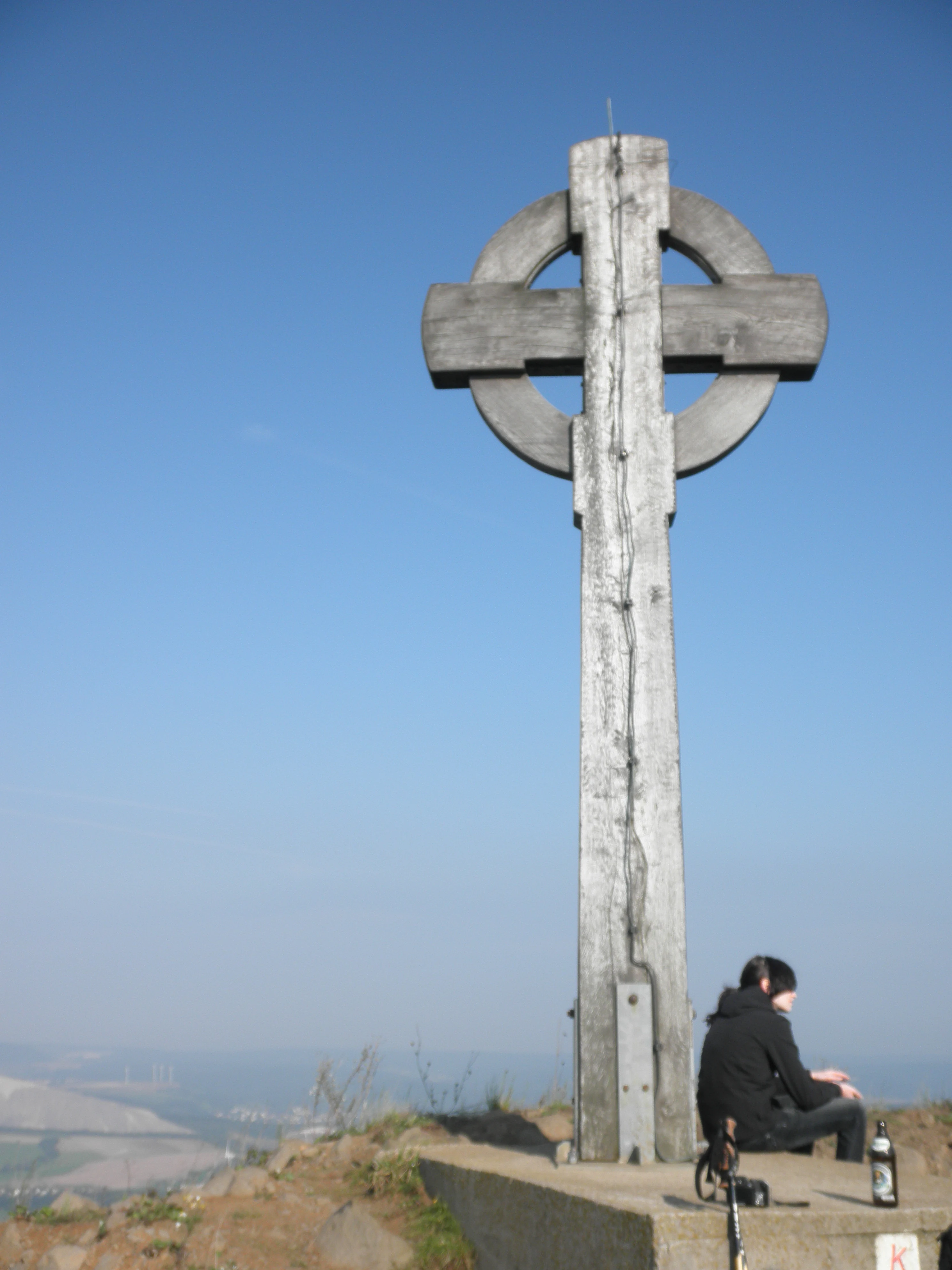
A large wooden Celtic cross stands on a concrete plinth at the top of a mountain, with a person sitting on the edge of the base looking out over the landscape.
A person resting at the Celtic cross monument on the summit of Öchsenberg.

Öchsenberg ecosystems, habitats, and plant life

Ecologically, the Öchsenberg is dominated by woodland. The beech slopes cover large parts of the mountain; on better soils these forests are rich in characteristic spring herbs, while rockier terrain hosts rarer, edaphic-specialist communities.

The extensive scree and block slopes give rise to so-called Blockschuttwälder, scree woodland communities featuring species such as wild orchids, while the climax communities on deeper soils include large stands of Zahnwurz-Buchenwald, a type of beech forest notable for the protected Turkish cap lily, Türkenbundlilie. Together these forest types occupy most of the protected reserve.

Abandoned basalt quarries create an additional habitat layer. Their sunny but sheltered walls and partially overgrown ledges support a mosaic of bushes, birches, and specialized plant life, and provide refuge for warmth-loving invertebrates and birds. The mosaic of mature forest, fresh rock vegetation, and open quarry landscape is the core ecological signature of the Öchsenberg nature reserve.

A wide panoramic view taken from a high vantage point, looking over a rolling green landscape with forests, agricultural fields, and a prominent white, cone-shaped industrial tailing heap in the distance.
A northwest summit panorama overlooking the surrounding landscape from the Öchsenberg, featuring distant hills and a notable white tailings pile.

Öchsenberg wildlife and species highlights

Although wildlife is not the main focus of the reserve, the Öchsenberg offers habitat for several notable species. The eagle owl, Uhu, is the most prominent, breeding in the rock faces of the abandoned quarries and a focal species for conservation management in the area.

The mosaic of mature beech forest, block-field woodland, and open quarry walls supports a varied community of birds typical of the Rhön, alongside small mammals, bats, and invertebrates associated with rocky, structurally complex terrain. Because the protected area lies within the UNESCO Rhön Biosphere Reserve, its fauna is integrated into broader regional monitoring of forest and cliff communities.
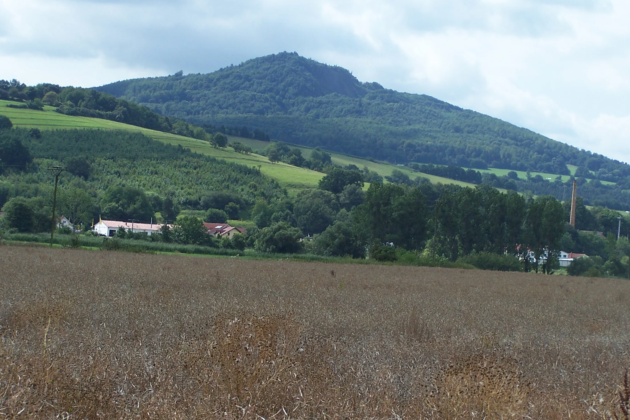
A rural landscape featuring a large, forested basalt mountain in the distance, viewed across an agricultural field with a few small buildings and a chimney visible at the base.
A wide view of the forested Öchsenberg mountain rising above the surrounding fields near Badelachen.

Öchsenberg conservation status and protection priorities

The Öchsenberg has been protected as a nature reserve since 1990, following the end of basalt quarrying in 1986 and the German reunification. The reserve covers approximately 267 hectares and is formally a Pflegezone, a managed zone, of the UNESCO Rhön Biosphere Reserve.

Conservation priorities focus on the preservation of the beech forest communities, the rare scree woodland of the basalt block fields, and the species-rich habitats of the abandoned quarries, including the eagle owl. Public access is limited to marked hiking trails to avoid disturbance of sensitive habitats, and the restoration of pathways after the closure of military and industrial restrictions has been carefully coordinated with habitat protection.

Öchsenberg cultural meaning and human context

Culturally, the Öchsenberg is anchored in the identity of Vacha and the wider Werra region. For the town below, the mountain has long served as a defining landmark, and a 1655 engraving by Matthäus Merian the Younger already shows the peak towering over Vacha's roofscape.

The most prominent cultural layer is the Iron Age Celtic hillfort with its multiple basalt ring walls. These ruins, along with the reconstructed Celtic cross near the summit, shape how visitors experience the mountain today. A nearby open-air museum, the Keltendorf Sünna, presents reconstructions and information about Celtic life on the mountain and adds an educational dimension to a visit. The 19th-century tradition of hiking clubs, initiated locally by the Rhön Club Vacha, also remains an active element of the site's cultural life.

Top sights and standout views in Öchsenberg

The Öchsenberg combines three distinct layers of significance in one compact mountain: the eroded remnant of a Tertiary volcano, an extensive beech and scree forest protected as a biosphere reserve zone, and one of the largest Celtic hillforts in Thuringia. The visible ring walls, basalt block fields, and quartz-rich viewpoints give the mountain a strongly layered identity.

For travelers, the highlights include the panoramic summit views across the northern Rhön and the Werra valley, the abundance of marked long-distance hiking trails crossing the peak, and the proximity of the Keltendorf Sünna open-air museum, which links the mountain's natural and archaeological significance into a single visitor experience.

Best time to visit Öchsenberg

The Öchsenberg can be visited year-round, but the most rewarding seasons are late spring and early autumn. In late spring, the Turkish cap lilies and other woodland herbs of the beech forest come into bloom, while autumn brings clear views over the Rhön and the Werra valley and the colorful foliage of the mixed beech slopes.

In winter, the summit is often accessible but can be slippery, especially on the basalt block fields; visitors should be prepared for mountain weather. Because the reserve is crossed by several long-distance hiking trails, visitors can combine a trip to the Öchsenberg with broader Rhön itineraries, but marked winter routes are sometimes limited.


Monthly climate preview

Long-term temperature and precipitation records across the representative coordinate

Öchsenberg Climate Normals and Measured Weather by Month

Representative point records outline the multi-year temperature ranges and precipitation rhythm across Öchsenberg from historical climatology data. Examining the complete monthly normals provides deeper insight into measured baseline conditions across the protected terrain.
Annual mean8 °C
-1 °C18 °C
Jan-1°
Feb
Mar
Apr
May12°
Jun16°
Jul18°
Aug18°
Sep14°
Oct
Nov
Dec
Warmest month
July

18.3 °C

Coolest month
January

-1.1 °C

Wettest month
July

2.6 mm/day

Driest month
April

1.4 mm/day

Park location guide

Geography guide, regional context, and park location map for Öchsenberg

Öchsenberg park geography, regions, and map view in Germany

Understand where Öchsenberg sits in Germany through a broader geographic reading of the surrounding landscape, nearby location context, and its mapped position within the national park landscape.

How Öchsenberg fits into Germany

Germany is a federal republic in Western and Central Europe with a population of over 83 million across sixteen constituent states. It is Europe's largest economy by nominal GDP and a major global exporter and importer. The capital is Berlin, and the country borders Denmark, Poland, Czech Republic, Austria, Switzerland, France, Luxembourg, Belgium, and the Netherlands.

Wider geography shaping Öchsenberg in Germany

Germany is located in Western and Central Europe, spanning 357,022 km². It borders Denmark to the north, Poland and the Czech Republic to the east, Austria and Switzerland to the south, and France, Luxembourg, Belgium, and the Netherlands to the west. The country has coastlines on the Baltic Sea and North Sea to the north, with the Alps located in the southern region.

Map view of Öchsenberg

Use this park location map to pinpoint Öchsenberg in Germany, understand its exact geographic position, and read its mapped placement within the surrounding landscape more clearly.

Pigeon | © OpenStreetMap contributors

Location context for Öchsenberg

Thuringia

Explore the forest habitats, rugged terrain, and protected scenery of the Rhön highlands

Öchsenberg Photos and Landscapes: Visualizing the Volcanic Basalt Dome

Visual records reveal the distinctive basalt domes, scree slopes, and beech woodlands that define the topography of Öchsenberg. Examining these protected habitats provides a deeper understanding of the volcanic geology and ancient settlement remnants shaping the regional landscape.

A sunny view of a steep, rocky basalt hillside with a wooden cross at the summit against a blue sky.

Panoramic landscape view from a high vantage point overlooking rolling forested hills, valleys, and distant mountains under a cloudy sky.

A large wooden Celtic cross stands on a concrete plinth at the top of a mountain, with a person sitting on the edge of the base looking out over the landscape.

A wide panoramic view taken from a high vantage point, looking over a rolling green landscape with forests, agricultural fields, and a prominent white, cone-shaped industrial tailing heap in the distance.

A rural landscape featuring a large, forested basalt mountain in the distance, viewed across an agricultural field with a few small buildings and a chimney visible at the base.

High angle shot of an abandoned, overgrown quarry with exposed rock faces and shrubs, looking down towards a green valley with a town, agricultural fields, and a distant white industrial slag pile.

Park atlas

Compare nearby regional reserves and volcanic highland landscapes

Other Protected Areas and Parks Near Öchsenberg in the Rhön Highlands

Browsing other parks near Öchsenberg reveals connected protected landscapes across the surrounding region. Comparing these regional highlands provides deeper context on basalt formations and woodland habitats.
Nature reserveThuringia
About 3.2 km away#1 closest

Northeast

Werra-Aue zwischen Breitungen und Creuzburg: Protected Floodplain and River Geography

Nature reserve sanctuary in western Thuringia

Spanning over 33 kilometers of the Werra river, this protected floodplain is defined by its distinctive geological sinkholes, seasonal wetlands, and diverse bird habitats. Discover the layered conservation status and riparian terrain that mark this significant Thuringian nature reserve as a crucial node for European ecological connectivity.

Area
25.78 km²
Established
2007
IUCN
IV
Relief
Lowland
Nature reserveThuringia
About 3.3 km away#2 closest

Northeast

Werra bis Treffurt mit Zuflüssen: Protected River and Floodplain Network in Thuringia

Mapping an extensive 191 kilometer Natura 2000 river corridor.

The Werra bis Treffurt mit Zuflüssen protected area serves as a vital ecological corridor in Thuringia. This site encompasses a complex mosaic of fast-flowing highland brooks, expansive floodplain meadows, inland salt sites, and rare dissolution lakes. Its geography bridges high-altitude source regions with lower river valleys, creating a distinctive landscape transect that supports essential freshwater habitats and rare aquatic species across the state.

Area
22.6 km²
Established
2008
IUCN
IV
Relief
Mixed relief
Nature reserveHessen
About 8.3 km away#3 closest

Southwest

Buchenberg, Grisselborner Wäldchen und Taftgrund bei Soisdorf Nature Reserve Geography

A protected habitat complex in the Hessian Kuppenrhön.

The Buchenberg, Grisselborner Wäldchen und Taftgrund bei Soisdorf reserve serves as a prime example of a balanced protected landscape. It spans deciduous woodlands, hedge-row mosaics, and valley stream habitats. This data set provides a clear view of its structured boundaries and its importance as a refuge within the northern Rhön foothills, illustrating the interplay between hilltop forest and stream-side meadow ecosystems.

Area
0.826 km²
Established
1994
Relief
Upland
Climate
Temperate
Nature reserveWartburgkreis
About 8.9 km away#4 closest

Northeast

Brühl von Merkers Nature Reserve: Floodplain Geography in the Wartburgkreis District

Protected Werra valley meadows and wetland ecosystems

Brühl von Merkers preserves a rare, open stretch of Werra river floodplain within Germany. This nature reserve offers a detailed look at extensively managed grasslands and wetland habitats that support avian populations and maintain regional ecological integrity within the Wartburgkreis administrative area.

Area
1.756 km²
Established
2014
IUCN
IV
A soft watercolor illustration of a wetland scene with light blue water in the foreground, green trees in the midground, and soft pink hills in the background.
Nature reserveHessen
About 11 km away#5 closest

North

Rohrlache von Heringen Protected Area and Werra Valley Wetland Geography

Nature reserve featuring rare saline meadows and alluvial terrain

Rohrlache von Heringen stands as the largest inland saline site in Hesse. This protected area preserves a rare ecosystem of salt-tolerant flora and vital breeding grounds for waterbirds, shaped by both natural Zechstein geology and long-term industrial influences along the Werra river floodplain.

Area
0.765 km²
Established
1979
IUCN
IV
Relief
Lowland
A soft watercolor illustration of rolling green hills under a sparse, light sky.
Nature reserveHessen
About 11 km away#6 closest

Northwest

Landecker Berg: A Detailed Look at the Nature Reserve and Mountain Geography in Hessen

Exploration of the Rhön table mountain and protected landscape.

Landecker Berg presents a classic example of a Triassic limestone massif in the northern Kuppenrhön. This nature reserve, located in the German state of Hessen, offers significant geographic interest due to its flat-topped plateau and dense forest mantle. Navigate the mapped boundaries of this protected area, which features unique geological formations, surrounding castle ruins, and an integral role in the local watershed systems.

Area
1.044 km²
Established
1992
Relief
Mountain
Climate
Temperate
Nature reserveThuringia
About 15 km away#7 closest

Southeast

Ibengarten Nature Reserve: Protected Yew Forest Landscape in the Thuringian Rhön

A historic protected area preserving rare ancient yew stands in central Germany.

Ibengarten encompasses a 56-hectare reserve in Thuringia, recognized for its dense concentration of wild European yew trees. This unique woodland environment, set against the basalt ridges of the Rhön, provides an essential look at historical conservation efforts and old-growth forest dynamics in the German low mountains.

Area
0.561 km²
Established
1938
IUCN
IV
A soft watercolor illustration of a calm pond surrounded by green vegetation and rolling hills in the background.
Nature reserveWartburgkreis
About 15 km away#8 closest

North

Dankmarshäuser Rhäden: Protected Wetland Reserve and Mapped Floodplain in Wartburgkreis

Restored basin landscape along the historic Green Belt corridor.

Dankmarshäuser Rhäden comprises a complex wetland mosaic in the Wartburgkreis district. This nature reserve, characterized by shallow subsidence basins and active floodplain management, represents a critical migratory bird sanctuary and a key component of the protected Green Belt. The area reveals a history of land-use transition, from agricultural depression to a functional, water-managed ecosystem supporting diverse meadow-nesting and migratory bird populations.

Area
1.217 km²
Established
1995
IUCN
IV

Common questions about visiting, size, designation, and location context for Öchsenberg

Öchsenberg FAQs for park facts, access, geography, and protected area context

Find quick answers about Öchsenberg, including protected-area facts, park geography, trail and visitor context, and how the park fits into its surrounding country and regional landscape.
MoriAtlas Explorer

Continue Your Protected Areas Search Across the Global Atlas

Deepen your exploration by continuing the structured search for national parks and protected areas worldwide. Utilize the comprehensive filtering capabilities to compare different conservation landscapes and refine your understanding of global park geography. Discover more about the distribution and characteristics of protected natural areas.

Global natural geography