
Mori Atlas logo
Nature reserveOchsenhof

A compact riverine wetland at the forested edge of the Reinhardswald in northern Hessen.

Ochsenhof Nature Reserve: Mapped Protected Landscapes and Weser Floodplain Geography

Ochsenhof nature reserve occupies a key position within the floodplain of the Upper Weser river in Hessen. This protected area features two near-natural still-water lakes formed from former gravel pits, surrounded by a mosaic of reedbeds, riparian woodland, and traditionally mown grassland. Situated between the forested slopes of the Reinhardswald and the main Weser channel, the reserve serves as a critical wetland habitat and an ecologically linked component of the wider Weserhänge mit Bachläufen protected territory.

nature reservewetlandfloodplainformer gravel pitsstanding waterriparian woodland
A digital illustration of a mountainous valley featuring a tall waterfall cascading into a lake, surrounded by birch and pine trees with rocks in the foreground under a pale sun.

Ochsenhof

Nature reserve

Park overview

Structured park overview, official facts, and landscape profile for Ochsenhof Nature Reserve

Ochsenhof Nature Reserve park facts, protected area profile, and essential visitor context

Review the core facts for Ochsenhof Nature Reserve, including designation, size, terrain, visitor scale, habitats, and operating context in one park-focused overview.

About Ochsenhof Nature Reserve

Ochsenhof is a compact nature reserve in northern Hesse, Germany, situated in the floodplain of the River Weser where the river passes the eastern edge of the Reinhardswald. Although it covers only about 24 hectares, the reserve has a clear and well-defined ecological role: it protects a mosaic of small standing waters, riverside woodland, reeds, herbaceous shoreline vegetation, and traditionally used grassland right along a stretch of the Weser.

The most distinctive feature of Ochsenhof is its two near-natural still-water lakes. Both originated as gravel pits, opened along the Weser floodplain as part of commercial Kiesgewinnung. Extraction was halted in the second half of the 1970s, and the abandoned pits gradually transformed into the kind of nutrient-poor, quiet standing waters that support reeds, submerged vegetation, and waterfowl. The reserve therefore reads as a landscape of second nature: an industrial footprint that, after several decades, has been absorbed back into a functioning floodplain ecosystem.

Around the lakes, the reserve protects wooded margins, patches of reedbed (Röhricht) along the banks, and narrow strips of herbaceous shoreline vegetation along the Weser itself. Between the lakes and the river lies a tract of grassland that is still actively farmed, providing open ground within an otherwise wooded scene. To the west, the reserve meets the Bundesstraße 80 beyond which the dense forest communities of the Reinhardswald begin, while to the south it borders agricultural cropland.

The reserve was formally placed under protection on 13 October 1981 under the designation 1633008, and a substantial part of its area falls within the larger EU Habitats Directive site "Weserhänge mit Bachläufen." It also abuts the neighbouring nature reserve Thorengrund to the west, so that Ochsenhof functions less as an isolated site and more as one node in a broader corridor of protected floodplain, riverside, and forest habitats along the Upper Weser.

Quick facts and research context for Ochsenhof Nature Reserve

Ochsenhof is a designated Naturschutzgebiet (nature reserve) in the Gemeinde Reinhardshagen, Landkreis Kassel, in the German state of Hesse. It lies on the edge of the Naturpark Reinhardswald, between Hann. Münden and Bodenfelde, in the floodplain of the Upper Weser.

The protected area covers approximately 24 hectares and has carried the official designation 1633008 since 13 October 1981. A significant portion of the reserve forms part of the FFH (Fauna-Flora-Habitat) site "Weserhänge mit Bachläufen," and it adjoins the neighbouring nature reserve Thorengrund to the west. Its habitat mosaic of still waters, riparian woodland, reedbeds, grasslands, and river shoreline reflects the legacy of former gravel extraction, which ended in the mid-1970s.

Protection and recognition

Examine documented protected area records and official designation criteria

Ochsenhof Protection Status and International Recognition Data

Ochsenhof brings together verified protection status metrics and official administrative designations within a structured conservation record. Analysts review compiled database entries to trace management scope and international recognition frameworks.

Protection details

WDPA ID
82273
Park context

Deeper park guide and search-rich context for Ochsenhof Nature Reserve

Ochsenhof Nature Reserve history, landscape, wildlife, and travel context

Explore Ochsenhof Nature Reserve through its history, landscape character, ecosystems, wildlife, conservation priorities, cultural context, and seasonal travel timing in a structured park guide built for atlas discovery and search intent.

Why Ochsenhof Nature Reserve stands out

Ochsenhof is best known for its two quiet, near-natural standing-water lakes that have matured from abandoned gravel pits into a coherent wetland reserve along the Weser. These former Kiesgruben now anchor a floodplain mosaic of riparian woodland, reed-fringed shorelines, herbaceous riverbank vegetation, and traditionally mown grassland that reaches down to the Weser itself. The reserve's strong association with the Weserhänge mit Bachläufen FFH site and its position on the river's floodplain give it a tightly defined identity: a compact lowland river reserve where reclaimed industrial waters, rewilded shoreline, and waterfowl habitat meet at the boundary between the forested Reinhardswald and open agricultural land.
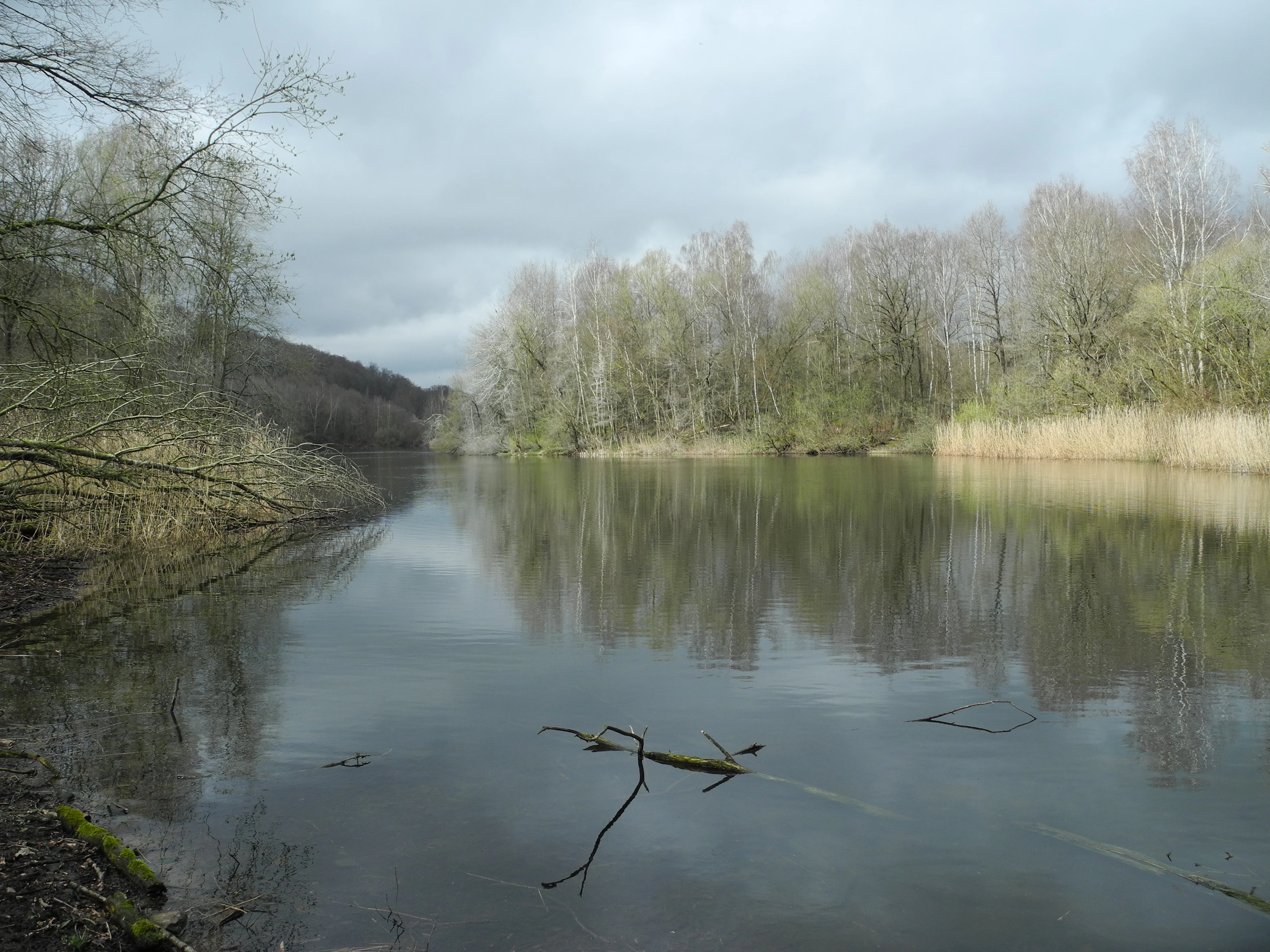
A wide shot of a tranquil, still pond in the Ochsenhof nature reserve, framed by bare trees and reeds under an overcast sky.
A calm pond within the Ochsenhof nature reserve, surrounded by early spring foliage and wetland vegetation.

Ochsenhof Nature Reserve history and protected-area timeline

The Ochsenhof nature reserve reflects a clear and relatively recent industrial-to-ecological transition. Both of the reserve's defining still-water lakes are former gravel pits that were worked for aggregate along the Weser floodplain. Commercial extraction of gravel at the site was halted in the second half of the 1970s, and the abandoned workings gradually filled with water and developed reed, woody, and shoreline communities typical of nutrient-poor standing waters.

On 13 October 1981, the area was formally designated as a Naturschutzgebiet under the number 1633008, codifying roughly a decade of natural regeneration as a protected management status. The reserve's integration into the larger FFH (Fauna-Flora-Habitat) site "Weserhänge mit Bachläufen" extends its recognized ecological significance beyond national protection, tying it into the EU Habitats Directive network. Its functional connection to the adjacent Thorengrund nature reserve to the west further positions Ochsenhof within a wider mosaic of floodplain and forest protected areas along the Upper Weser.

Ochsenhof Nature Reserve landscape and geographic character

Ochsenhof sits in the floodplain of the Upper Weser, on the very edge of the Reinhardswald, one of the largest connected forest tracts in Hesse. The defining landforms are flat and low-lying: two still-water lakes set within an otherwise gentle valley landscape, joined by stretches of riverside woodland and open grassland, and bordered on one side by the winding shoreline of the Weser itself.

The two lakes are the visual and ecological anchors of the reserve. Their origin as gravel pits has left them with shallow margins, exposed sediment fringes, and gently sloping shorelines that have allowed reeds, scrub, and woody vegetation to colonise in an irregular, naturalistic pattern. Between the lakes and the Weser, the reserve expands into a strip of flat, traditionally mown grassland, broken up by bands of riverside trees and patches of reedbed.

To the east the landscape is governed by the broad Weser valley itself; to the west, the reserve ends abruptly at the Bundesstraße 80, where the dense coniferous and mixed forests of the Reinhardswald rise up on the slopes beyond. To the south, the protected area meets open agricultural land, while to the north the floodplain continues upstream. The overall impression is of a small, sheltered riverland pocket pressed between forest, farmland, road, and the main river channel.

Ochsenhof Nature Reserve ecosystems, habitats, and plant life

The reserve protects a characteristic lowland floodplain habitat mosaic, with former gravel-pit lakes at its core and the Weser shoreline at its edge. The still waters are framed by woody margins and bordered in places by reeds (Röhricht), giving way along parts of the Weser itself to fringes of herbaceous riverside vegetation, or Uferstaudenfluren, interspersed with reed patches and woody growth.

Between the two lakes and the Weser, the reserve includes open grassland that continues to be used for hay-making or grazing, an important structural element that prevents the wooded margins from closing over the whole reserve. This combination of open water, wooded shoreline, reedbed, riverside scrub, and managed grassland produces a layered habitat pattern typical of healthy river-floodplain systems, and is the reason a significant share of Ochsenhof overlaps with the FFH site "Weserhänge mit Bachläufen."

Together, these habitats form a compact refuge for wetland and riverside species in a landscape that is otherwise dominated by the forests of the Reinhardswald to the west and by open farmland to the south. The reserve's value lies precisely in this contrast: small, but structurally diverse.

Ochsenhof Nature Reserve wildlife and species highlights

Ochsenhof's wildlife interest centers on waterbirds. The two still-water lakes, their reed-fringed margins, and the adjoining stretch of the Weser provide both feeding and refuge habitat for waterfowl, and the reserve is explicitly recognized as a resting and wintering area for these species.

Beyond waterfowl, the mix of open water, reedbed, shrubby margins, wooded riverbank, open grassland, and the adjacent Reinhardswald forest gives the reserve potential refuge value for typical wetland, riverside, and forest-edge fauna of the Upper Weser valley, including amphibians and invertebrates associated with standing water and reed habitats. Detailed species inventories are not strongly supported by the source material, so identification is best treated as ecosystem-based rather than species-list-based.

Ochsenhof Nature Reserve conservation status and protection priorities

Ochsenhof illustrates the conservation value of allowing post-industrial landscapes to recover under protected status. By formally designating the abandoned gravel pits and the adjoining floodplain as a Naturschutzgebiet in 1981, the authorities effectively locked in a process of ecological rewilding that had begun when gravel extraction stopped in the 1970s, ensuring that the former pits could mature into a coherent wetland habitat rather than being lost to redevelopment.

A substantial share of the reserve is incorporated into the EU Habitats Directive site "Weserhänge mit Bachläufen," giving Ochsenhof a recognized continental-level ecological status. Its location at the boundary between the forested Reinhardswald and the open Weser floodplain, alongside its connection to the adjacent Thorengrund nature reserve, also means that Ochsenhof functions as a small but meaningful connective element within a larger network of protected areas along the Upper Weser. The reserve's continued management of grassland between the lakes helps preserve the open habitat structure on which waterfowl depend.

Top sights and standout views in Ochsenhof Nature Reserve

Two former gravel-pit lakes, now still-water wetland anchors for waterfowl habitat, at the edge of the Reinhardswald. A genuinely floodplain-scale landscape mosaic of open water, reeds, wooded riverbank, and grassland running down to the Weser shoreline.

Direct integration into the FFH site "Weserhänge mit Bachläufen," and immediate ecological continuity with the neighbouring Thorengrund nature reserve to the west. A compact example of how a halted industrial activity on the Weser floodplain has, over a few decades, been converted into a functioning nature reserve.

Best time to visit Ochsenhof Nature Reserve

The character of Ochsenhof shifts with the seasons in ways typical of central European river-floodplain reserves. Spring and early summer are likely to bring the most active bird presence around the lakes and the Weser shoreline, with reed and waterside vegetation at their fullest. Late summer and autumn tend to be quieter on the water but coincide with peak waterfowl migration and the first gathering of wintering birds, which the reserve is explicitly recognized to support. Winter can bring stillness and reduced vegetation cover, making waterfowl more visible against the open water and the leafless riparian woodland.

Given the reserve's modest size and the kind of small standing waters and river shoreline that define it, periods when water levels are comfortably visible and the reedbeds are not yet fully grown tend to be most rewarding for casual visiting observers.

Monthly climate preview

Long-term monthly temperature averages and precipitation rhythms across the coordinate point

Ochsenhof Climate Normals, Annual Temperature and Precipitation Patterns

Historical data records multi-year average temperatures and steady daily precipitation rates across the representative coordinate point in Hessen. Exploring the complete twelve-month climatology reveals full monthly ranges and detailed long-term trends.
Annual mean8 °C
-1 °C18 °C
Jan-1°
Feb
Mar
Apr
May12°
Jun16°
Jul18°
Aug18°
Sep14°
Oct
Nov
Dec
Warmest month
July

18 °C

Coolest month
January

-0.6 °C

Wettest month
July

2.5 mm/day

Driest month
April

1.5 mm/day

Park location guide

Geography guide, regional context, and park location map for Ochsenhof Nature Reserve

Ochsenhof Nature Reserve park geography, regions, and map view in Germany

Understand where Ochsenhof Nature Reserve sits in Germany through a broader geographic reading of the surrounding landscape, nearby location context, and its mapped position within the national park landscape.

How Ochsenhof Nature Reserve fits into Germany

Germany is a federal republic in Western and Central Europe with a population of over 83 million across sixteen constituent states. It is Europe's largest economy by nominal GDP and a major global exporter and importer. The capital is Berlin, and the country borders Denmark, Poland, Czech Republic, Austria, Switzerland, France, Luxembourg, Belgium, and the Netherlands.

Wider geography shaping Ochsenhof Nature Reserve in Germany

Germany is located in Western and Central Europe, spanning 357,022 km². It borders Denmark to the north, Poland and the Czech Republic to the east, Austria and Switzerland to the south, and France, Luxembourg, Belgium, and the Netherlands to the west. The country has coastlines on the Baltic Sea and North Sea to the north, with the Alps located in the southern region.

Map view of Ochsenhof Nature Reserve

Use this park location map to pinpoint Ochsenhof Nature Reserve in Germany, understand its exact geographic position, and read its mapped placement within the surrounding landscape more clearly.

Pigeon | © OpenStreetMap contributors

Location context for Ochsenhof Nature Reserve

Hessen

Explore protected floodplain habitats, standing water lakes, and river valley terrain.

Ochsenhof Photos, Landscapes, and Wetland Scenery Visual Reference

Visual documentation captures the unique wetland terrain, riparian woodland, and open water lakes defining the protected landscape around Ochsenhof. Examining these environmental details reveals how former industrial gravel pits have matured into vital waterfowl habitats along the Weser valley.

A wide shot of a tranquil, still pond in the Ochsenhof nature reserve, framed by bare trees and reeds under an overcast sky.

Park atlas

Compare surrounding lowland wetlands and protected riparian corridors across northern Hesse

Exploring Parks Near Ochsenhof, Protected Landscapes and Regional Weser Valley Reserves

Visitors exploring Ochsenhof can browse nearby protected areas to compare floodplain habitats and regional valley landscapes. Expanding the geographic scope reveals connected conservation zones across the wider Weser river corridor.
Protected landscapeHessen
About 4.8 km away#1 closest

West

Naturpark Reinhardswald: A Comprehensive Protected Landscape Atlas for Northern Hessen

Mapping forest ecosystems and limestone river valleys

Naturpark Reinhardswald protects a diverse mosaic of environments across northern Hessen, characterized by the contrast between extensive sandstone-dominated forests and open limestone grasslands. The terrain features historic woodland pastures, basalt outcrops, and riverine floodplains, providing a significant regional network of nature reserves and protected areas that represent both upland forest and valley ecosystems.

Area
448.51 km²
Established
2017
Relief
Mixed relief
Scope
Terrestrial
Nature reserveLower Saxony
About 9.8 km away#2 closest

Northeast

Wälder am Schäferstein und am Hohen Rott bei Verliehausen: Protected Nature Reserve Landscape

Ancient woodland geography in the Southern Solling uplands

A significant nature reserve in Lower Saxony, these forest tracts at Schäferstein and Hohen Rott protect near-natural beech and oak stands. The site is characterized by an exceptional density of deadwood and historical relict oak pastures, serving as a vital sanctuary for specialized saproxylic beetles and cavity-nesting birds within the broader Solling ridge system.

Area
1.02 km²
Established
2020
Relief
Mountain
Climate
Temperate
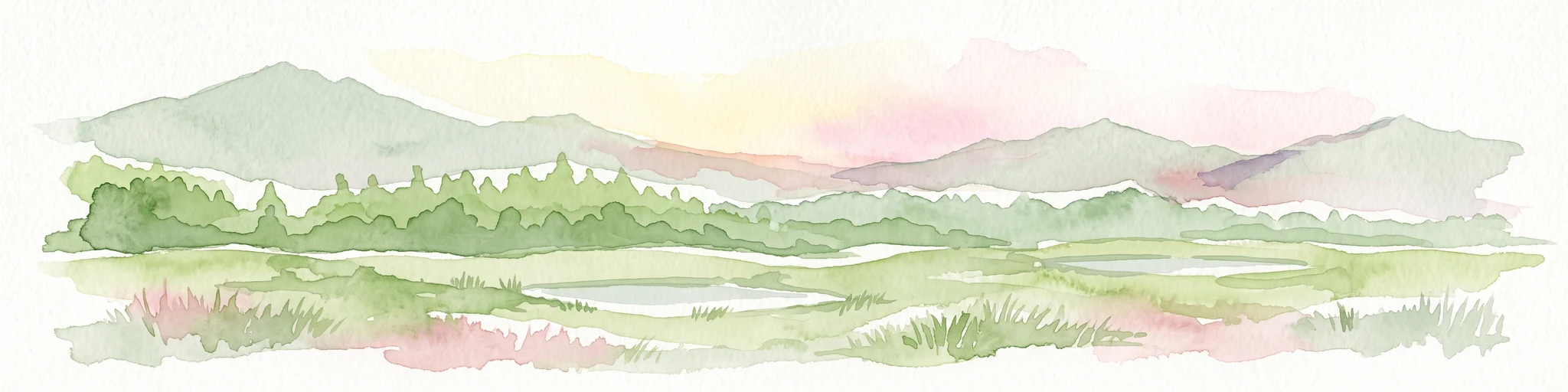
A soft watercolor illustration depicting a green, marshy landscape with small pools of water, a line of forest, and rolling hills in the background under a pale sky.
Nature reserveHesse
About 11 km away#3 closest

South

Bruch an der Eichkanzel im Reinhardswald: Protected Nature Reserve Geography in Hesse

Mapped birch swamp forests and highland bog terrain

Examine the geographic profile of Bruch an der Eichkanzel im Reinhardswald, a nature reserve in Hesse defined by its upland plateau. Learn about the interaction between its birch swamp forests and open moorland habitats, characterized by sphagnum mosses and aquatic features, within the broader context of the Reinhardswald forest region.

Area
0.175 km²
Established
1992
Relief
Upland
Scope
Terrestrial
Watercolor painting of a soft landscape featuring green trees and rolling hills in muted tones against a white background.
Nature reserveGermany
About 13 km away#4 closest

South

Bruchwald am Gahrenberg Nature Reserve: A Protected Wetland Atlas of the Reinhardswald

Mapped terrain, bog woodland, and hydrological headwaters in Hessen

Located in the Reinhardswald forest massif, Bruchwald am Gahrenberg protects critical marsh and bog woodland habitats. The area serves as a primary source for regional streams, offering a dense, spring-fed landscape that stands out within the broader northern German wilderness.

Area
0.41 km²
Established
1992
Relief
Upland
Climate
Temperate
A soft watercolor illustration showing a band of green trees reflecting in calm water, with a light hilly background.
Nature reserveHessen
About 13 km away#5 closest

Southwest

Bennhäuser Teich und Rothbalzer Teich bei Immenhausen: Protected Nature Reserve and Landscape Atlas

Mapped woodland and wetland habitats in Hessen, Germany.

This nature reserve centers on historic impoundment ponds and complex valley hydrology. Its landscape features rare dragonfly habitats and successional carr woodlands that define the ecological identity of this protected area within the northern Hessen countryside.

Area
0.315 km²
Established
1998
Nature reserveNiedersachsen
About 14 km away#6 closest

Northwest

Wälder im südlichen Solling Nature Reserve: A Detailed Atlas of German Protected Woodlands

Ecological mapping of Niedersachsen's southern Solling forest complexes.

Navigate the protected boundaries and landscape character of Wälder im südlichen Solling. This nature reserve provides an essential study in forest conservation, highlighting the intersection of traditional wood-pasture management and steep, near-natural slope forest ecosystems within the Solling-Vogler upland.

Area
10.16 km²
Established
2020
Relief
Upland
Climate
Temperate
A soft watercolor painting of gentle green rolling hills and meadows under a faint pink sky.
Nature reserveHesse
About 15 km away#7 closest

West

Flohrberg und Ohmsberg bei Deisel Nature Reserve; Calcareous Landscape and Park Boundaries

A protected Hessian site near Trendelburg

Situated in the Landkreis Kassel, Flohrberg und Ohmsberg bei Deisel encompasses 107 hectares of calcareous ground, disused quarries, and sheep-grazed grasslands. The area provides a critical landscape context for orchid-rich flora and rare butterfly fauna within the northern Hessian hill country, acting as a protected link between open farmland and the Reinhardswald forest edge.

Area
0.418 km²
Established
1990
A soft watercolor illustration showing rolling green hills, distant mountains, and forested slopes on a white background.
Nature reserveHesse
About 15 km away#8 closest

West

Dingel und Eberschützer Klippen: Protected Landscapes and Geography in Hesse, Germany

A dense mosaic of limestone slopes, juniper scrub, and beech forest communities.

Discover the geographic identity of Dingel und Eberschützer Klippen, a combined nature reserve and Natura 2000 site in northern Hesse. The protected area features a unique concentration of orchid-rich habitats, south-facing limestone slopes, and broadleaf forest blocks that define this essential part of the Reinhardswald region.

Area
1.123 km²
Established
1987
Relief
Upland
Climate
Temperate

Common questions about visiting, size, designation, and location context for Ochsenhof Nature Reserve

Ochsenhof Nature Reserve FAQs for park facts, access, geography, and protected area context

Find quick answers about Ochsenhof Nature Reserve, including protected-area facts, park geography, trail and visitor context, and how the park fits into its surrounding country and regional landscape.
MoriAtlas Explorer

Continue Your Protected Areas Search Across the Global Atlas

Deepen your exploration by continuing the structured search for national parks and protected areas worldwide. Utilize the comprehensive filtering capabilities to compare different conservation landscapes and refine your understanding of global park geography. Discover more about the distribution and characteristics of protected natural areas.

Global natural geography