Mori Atlas logo
Nature reserveOstoja Wierzejska

Geographic boundaries and forest habitat diversity within the Masłowskie Range

Ostoja Wierzejska Nature Reserve: Protected Forest Landscapes of the Świętokrzyskie Mountains

(Ostoja Wierzejska (PLH260035))

Ostoja Wierzejska represents a critical protected landscape situated on the northern edge of Kielce within the Świętokrzyskie Mountains of central Poland. This nature reserve safeguards rare Świętokrzyskie fir forest communities, acidic beech stands, and complex peatland habitats across a quartzite ridge. The site functions as a vital ecological corridor, maintaining connectivity for diverse forest species despite the surrounding transport infrastructure and suburban expansion.

Natura 2000Special Area of ConservationŚwiętokrzyskie Mountainsfir forestmixed forestbeech forest

Ostoja Wierzejska

Nature reserve

Park overview

Structured park overview, official facts, and landscape profile for Ostoja Wierzejska

Ostoja Wierzejska park facts, protected area profile, and essential visitor context

Review the core facts for Ostoja Wierzejska, including designation, size, terrain, visitor scale, habitats, and operating context in one park-focused overview.

About Ostoja Wierzejska

Ostoja Wierzejska is a compact but ecologically dense Natura 2000 refuge in Poland's Świętokrzyskie Mountains, designated to protect one of central Europe's culturally and scientifically distinctive forest types. It sits on the northwestern flank of Góra Wierzejska, within the Masłowskie Range, on the edge of the regional capital Kielce, and represents a living fragment of the ancient forest landscapes that once covered the Kielce-Sandomierz Upland. Although modest in size, its protected habitats and species composition make it a key node in the Natura 2000 network of Świętokrzyskie Voivodeship.

The site lies on Lower Devonian quartzite sandstones with interbedded conglomerates, mudstones, and claystones, blanketed in places by Quaternary weathering debris and glacial and glaciofluvial sediments. This geological base supports sandy, acidic, and often moisture-retaining forest soils that favor fir, beech, and pine. The forests occupy a small but typical cross-section of the range, capturing the full ecological gradient from dry quartzite ridges with acidic beech woodland, through mesic fir-beech forest, down into the moist stream valleys where alder, ash, willow, and poplar communities dominate. Small open patches preserve Molinia meadows and transitional peatlands that add further ecological diversity.

Despite the strong pressures of urban proximity and infrastructure, the woodland retains many of the structural features of natural forest, including trees aged from roughly 45 to over 200 years, abundant standing and fallen deadwood in varying states of decay, and undisturbed microhabitats along small forest streams. These features underpin the site's importance for saproxylic fungi, rare lichens, invertebrates, forest birds, and bats. Its role as a crossing point for a supra-local ecological corridor gives it significance well beyond its boundaries, helping to connect the larger forest complexes of the western and central Świętokrzyskie Mountains.

Quick facts and research context for Ostoja Wierzejska

Ostoja Wierzejska is a Special Area of Conservation (habitat保护区) under the European Union Natura 2000 network, with the site code PLH260035. It lies in Świętokrzyskie Voivodeship, Kielce County, in Gmina Masłów, and is administered as part of the Dąbrowa forest district of the Kielce Forest Management Unit.

The site occupies 224.64 hectares and is entirely forested, sitting on the western end of the Masłowskie Range on the Wierzejska Hill ridge within the broader Kielce-Sandomierz Upland. It was formally established in 2011, and its primary conservation interest is the Świętokrzyskie fir forest community, complemented by acidic beech forest, oak-hornbeam forest, nutrient-rich beech forest, alder-ash and willow-poplar floodplain forests, small Molinia meadows, and transitional peatlands. The area is traversed by a supra-local ecological corridor linking larger forest complexes of the Świętokrzyskie Mountains.

Protection and recognition

Documented terrestrial protection scope and international recognition sources for Ostoja Wierzejska

Ostoja Wierzejska Protection Status and Natura 2000 Recognition

Documented protection status and management scope provide clear insight into the terrestrial conservation framework established for Ostoja Wierzejska. Official records outline specific Natura 2000 designations that define the international recognition framework for this protected area.

International recognition

Protection details

Protection scope
Terrestrial
Transboundary protection
No
Park context

Deeper park guide and search-rich context for Ostoja Wierzejska

Ostoja Wierzejska history, landscape, wildlife, and travel context

Explore Ostoja Wierzejska through its history, landscape character, ecosystems, wildlife, conservation priorities, cultural context, and seasonal travel timing in a structured park guide built for atlas discovery and search intent.

Why Ostoja Wierzejska stands out

Ostoja Wierzejska is best known for protecting one of the most characteristic forest types of the Świętokrzyskie Mountains: the Świętokrzyskie fir forest, a distinctive Abies-dominated community with strong phytosociological identity that is closely tied to the region's geological and climatic history. The site also stands out for the unusually high concentration of rare and protected species packed into a relatively small forest patch, including relict fungi, sundews, wild orchids, woodland butterflies, and a suite of mature-forest birds typically associated with much larger wilderness areas. Its second defining feature is the way an ecologically rich forest persists right on the doorstep of a regional capital. The site is bounded by the S7 expressway, a railway corridor, an active county road, expanding suburban sprawl of Kielce, and ongoing silvicultural management; yet within this heavily trafficked landscape it still anchors a functioning ecological corridor across the western Masłowskie Range.
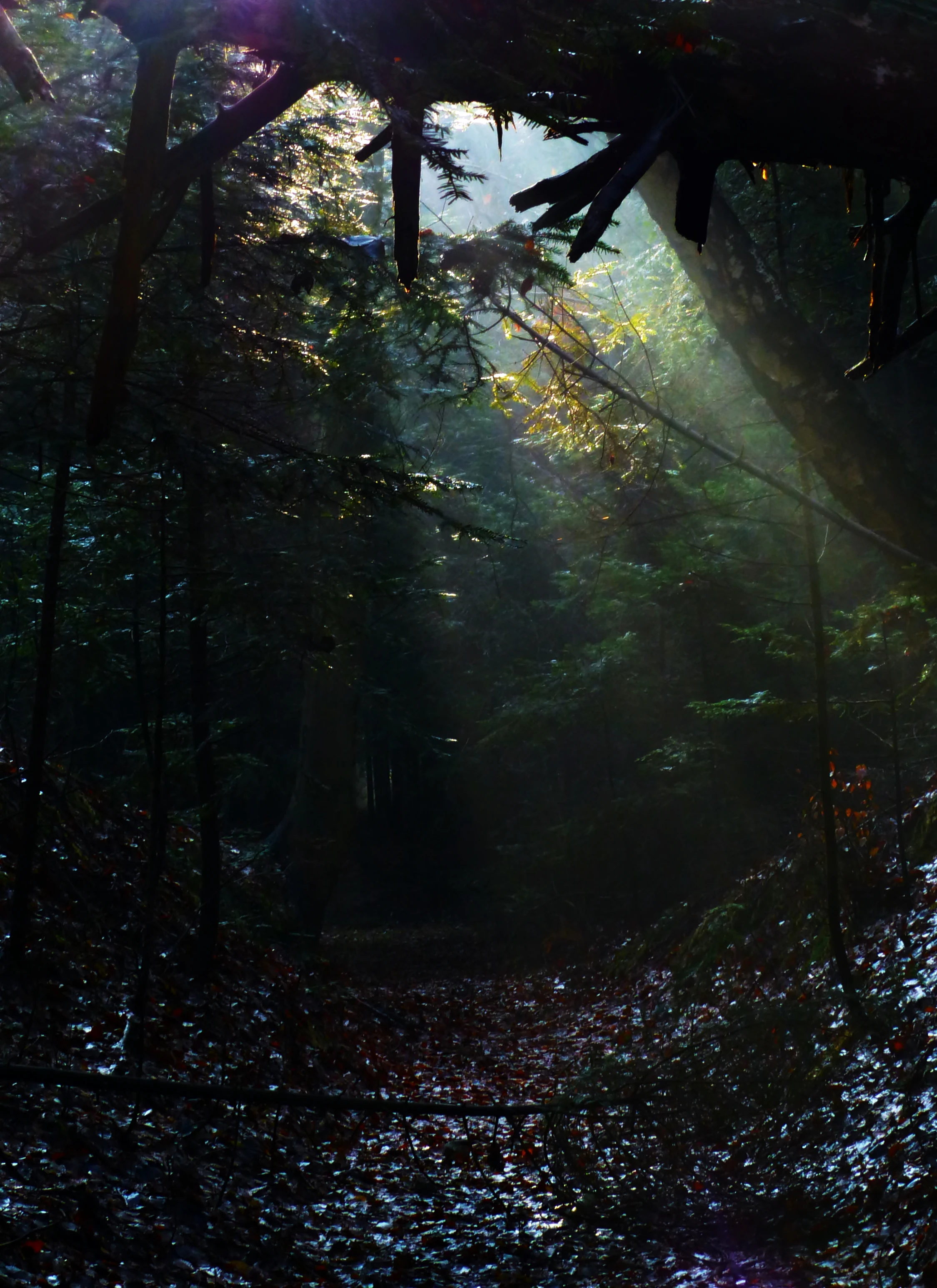
A dark forest interior with rays of sunlight piercing through the tree canopy and illuminating the leaf-covered ground.
Dramatic sunbeams pierce the dark canopy of the fir forest, illuminating the leaf-strewn forest floor.

Ostoja Wierzejska history and protected-area timeline

The Natura 2000 site Ostoja Wierzejska was formally established in 2011 as a Special Area of Conservation under the European Union Habitats Directive. Its creation reflects growing recognition in Poland of the ecological value of the Wierzejska forests, which had previously been protected only through ordinary forest management and the general provisions of national nature conservation law.

Although the protection designation is recent, the forests themselves are far older as a managed and used landscape. The woodlands of the Masłowskie Range, including those on Góra Wierzejska, have been shaped for generations by forestry activity, while simultaneously enduring heavy pressure from a growing Kielce, expanding transport infrastructure such as the S7 expressway, and recreational use. The 2011 designation was effectively an attempt to reconcile this long-standing economic and infrastructural pressure with the need to conserve the area's forest habitats, especially the Świętokrzyskie fir forest community and its associated species.

Since designation, the site has continued to operate under active forestry management, but with conservation obligations tied to its Natura 2000 status. Its history is therefore one of a working commercial forest gradually acquiring formal recognition as a refuge of regional and European ecological importance, and as an indispensable link in the wider network of protected forest habitats in the Świętokrzyskie region.

Ostoja Wierzejska landscape and geographic character

The landscape of Ostoja Wierzejska is defined by a low, forested mountain ridge set on the western edge of the Masłowskie Range in the Świętokrzyskie Mountains. Góra Wierzejska, the central topographical feature of the area, reaches roughly 375 meters above sea level and forms a compact quartzite spine running along the divide between more open agricultural land to the west and increasingly built-up territory to the east.

Geologically, the massif is built from Lower Devonian quartzite sandstones with subordinate conglomerates, mudstones, and claystones. The most resistant quartzite layers form the main ridge, while the slopes are mantled with Quaternary weathering products and glacial and glaciofluvial deposits from the South Polish glaciations of the early Pleistocene. North of the main ridge, the topography extends through the Tumlińskie Hills on Cambrian sandstones and mudstones and a secondary ridge of Triassic sandstones and mudstones along Sosnowica. Shallow stream valleys cut through the forest, filled mainly with Holocene silts, sands, and gravels and flanked by Pleistocene tills and meltwater deposits.

The visual character of the area is that of a dense, hilly forest landscape deeply indented by small valleys and traversed by small forest streams. Although much of the view is dominated by continuous woodland, narrow meadows, forest roads, and the S7 expressway corridor shape the wider setting, creating a strongly contrasting gradient between enclosed forest interior and the open urban-transport fringe along the eastern boundary of the site.

Ostoja Wierzejska ecosystems, habitats, and plant life

Ecologically, Ostoja Wierzejska is a mosaic of upland forest communities anchored by the Świętokrzyskie fir forest, an Abies-dominated phytosociological association known scientifically as Abietetum Polonicum and listed under the EU habitat code 91P0. Around this core community, the site preserves acidic beech forest of the Luzulo-Fagenion type, mid-European and subcontinental oak-hornbeam forest of the Galio-Carpinetum and Tilio-Carpinetum groups, nutrient-rich beech forest of the Dentario glandulosae-Fagenion and Galio odorati-Fagenion alliances, and a network of riparian communities along the small watercourses, including willow, poplar, alder, and ash floodplain forests.

Small and ecologically sensitive open habitats are also present, including dry pine forests and boggy spruce-pine forests on limited areas, as well as fragments of moist Molinia meadows and transitional peatlands with vegetation belonging to the Scheuchzerio-Caricetea group. The mosaic of dry ridges, mesic slopes, seepage zones, and stream valleys creates strong habitat diversity within the small footprint of the site, which is one of the main reasons it supports such a wide range of protected species.

Forest age structure is another defining ecological feature: tree stands range from roughly 45-year-old patches to stands over 200 years old, and the most humid, least accessible places retain large quantities of standing and fallen deadwood in varying states of decay. This structural complexity, combined with the abundance of old trees and microhabitats, is the key driver of the site's biodiversity and of its value for saproxylic and cavity-dependent species.

Ostoja Wierzejska wildlife and species highlights

The wildlife profile of Ostoja Wierzejska is unusually rich for such a small protected area. It supports a striking assemblage of rare fungi, including the fir-associated Hericium flagellum, the parasitic bolete Pseudoboletus parasiticus, and Pycnoporellus fulgens, as well as sundew Drosera rotundifolia, several orchid species, the imbricate gladiolus Gladiolus imbricatus, and the hard-fern Blechnum spicant among its notable plants.

Insects of conservation interest include the marsh fritillary Euphydryas aurinia, the large copper Lycaena dispar, and the Alcon blue Phengaris alcon, while the flat bark beetle Cucujus cinnaberinus is one of the site's two formal Natura 2000 conservation targets. Among vertebrates, the area is significant for the alpine newt Ichthyosaura alpestris, a community of mature-forest birds including the honey buzzard Pernis apivorus, black stork Ciconia nigra, hazel grouse Tetrastes bonasia, Ural owl Strix uralensis, boreal owl Aegolius funereus, Eurasian pygmy owl Glaucidium passerinum, stock dove Columba oenas, white-backed woodpecker Dendrocopos leucotos, middle spotted woodpecker Dendrocopos medius, grey-headed woodpecker Picus canus, and red-breasted flycatcher Ficedula parva, alongside mammals such as the western barbastelle Barbastella barbastellus, greater mouse-eared bat Myotis myotis, edible dormouse Glis glis, moose Alces alces, and gray wolf Canis lupus.

The combination of old, structurally complex forest, abundant deadwood, and a network of small watercourses allows many of these species to coexist within a very limited area, making the site disproportionately important for regional biodiversity.

Ostoja Wierzejska conservation status and protection priorities

Ostoja Wierzejska is significant from a conservation perspective because it protects a regionally distinctive habitat type; the Świętokrzyskie fir forest, and anchors one of the most species-dense Natura 2000 sites in the Świętokrzyskie voivodeship relative to its size. Its designation under the EU Habitats Directive commits Poland to maintaining the favorable conservation status of the listed habitats and species, and ties local forestry and land-use planning to legally defined ecological standards.

The site plays a critical role as a node and crossing point for a supra-local ecological corridor that links the larger forest complexes of the western and central Świętokrzyskie Mountains. Maintaining the integrity of this corridor is considered essential for the coherence of the Natura 2000 network across the voivodeship, especially as surrounding landscapes become increasingly fragmented by transport infrastructure and urban expansion.

Conservation management here is unusual: rather than being set aside as strict nature reserve, the area is an actively managed commercial forest that retains high natural values despite heavy anthropogenic pressure. The principal challenges are the urban fringe of Kielce, ongoing large infrastructure developments adjacent to the site, recreational pressure from the city, and forestry operations that historically lacked adequate ecological assessment, all of which threaten the long-term survival of its most sensitive habitats and species.

Ostoja Wierzejska cultural meaning and human context

Ostoja Wierzejska lies at the intersection of two long-standing cultural landscapes of central Poland: the ancient forest-working traditions of the Świętokrzyskie Mountains and the expanding urban territory of Kielce. The forests on and around Góra Wierzejska have been part of the regional timber economy for generations and have long served as a place of foraging, mushroom picking, and informal recreation for the inhabitants of Kielce.

The Świętokrzyskie Mountains themselves are a region of deep cultural resonance in Polish history, myth, and identity, associated with early medieval industrial activity, pilgrimage routes, and a strong tradition of forest craftsmanship. Although Ostoja Wierzejska is protected primarily for its ecological rather than cultural values, its setting within this historically significant mountain range and its proximity to one of Poland's older regional capitals give it an additional layer of regional identity that complements its formal conservation role.

Top sights and standout views in Ostoja Wierzejska

Ostoja Wierzejska stands out for the density and quality of its old-growth forest features inside a small footprint: multi-aged tree stands, abundant deadwood, and a continuous gradient from dry quartzite ridges to moist stream valleys, all within the administrative territory of a regional capital. It is one of the most important sites for the Świętokrzyskie fir forest habitat anywhere in Poland and combines this with acidic beech forest, oak-hornbeam forest, riparian forests, Molinia meadows, and transitional peatland habitats within a single compact unit.

The site also functions as a crucial ecological corridor across the western Masłowskie Range, helping to connect larger forest complexes of the Świętokrzyskie Mountains at a time when transport corridors and urban growth are increasingly fragmenting the landscape. Its species list, ranging from relict fungi and wild orchids through rare butterflies and saproxylic beetles to forest-specialist birds, bats, moose, and wolf, gives it a conservation profile that reaches well beyond what one would normally expect from an area of its size.

Best time to visit Ostoja Wierzejska

As a working forest protected primarily for its ecological values, Ostoja Wierzejska is best appreciated in late spring and early summer, when the canopy is fully leafed out, the ground flora of the fir and beech forests is at its most visible, and bird activity, including breeding displays of woodpeckers, owls, and forest passerines, is at its peak. Early mornings during this period offer the best chance of detecting the area's more elusive bird species, while damp weather conditions highlight the rich fungal and bryophyte interest of the old-growth stands.

Late summer and autumn can also be rewarding for visitors interested in mushrooms, a traditional regional activity, and in the changing character of the mixed fir-beech forest, though the area's narrow forest roads and proximity to busy transport corridors mean that quieter, less trafficked times of day generally provide a more rewarding experience. Visitors should remember that the site is a designated Natura 2000 area within an actively managed forest, so access may be restricted and activities limited to those compatible with its conservation objectives.

Monthly climate preview

Long-term representative point measurements tracking monthly weather patterns

Ostoja Wierzejska Climate Normals, Annual Temperature and Precipitation Rhythm

Representative point records for Ostoja Wierzejska trace measured monthly temperature ranges alongside baseline precipitation rates from 1991 to 2020. Examining the complete twelve-month climatology dataset reveals broader seasonal shifts and detailed temperature variations across the protected landscape.
Annual mean8 °C
-4 °C20 °C
Jan-4°
Feb-2°
Mar
Apr
May14°
Jun17°
Jul20°
Aug19°
Sep14°
Oct
Nov
Dec-2°
Warmest month
July

19.8 °C

Coolest month
January

-3.8 °C

Wettest month
July

2.9 mm/day

Driest month
January

1.3 mm/day

Park location guide

Geography guide, regional context, and park location map for Ostoja Wierzejska

Ostoja Wierzejska park geography, regions, and map view in Poland

Understand where Ostoja Wierzejska sits in Poland through a broader geographic reading of the surrounding landscape, nearby location context, and its mapped position within the national park landscape.

How Ostoja Wierzejska fits into Poland

Poland, officially the Republic of Poland, is a Central European country spanning from the Baltic Sea in the north to the Carpathian Mountains in the south. It borders Germany, Czech Republic, Slovakia, Ukraine, Belarus, Lithuania, and Kaliningrad Oblast. The country has a temperate climate, diverse landscapes, and is known for its rich history, cultural heritage, and strong economic position within the EU.

Wider geography shaping Ostoja Wierzejska in Poland

Poland occupies 312,696 km2 in Central Europe, extending from the Baltic Sea coast in the north to the Sudetes and Carpathian Mountains in the south. It borders Germany to the west, Czech Republic and Slovakia to the south, Ukraine and Belarus to the east, and Lithuania and Kaliningrad Oblast to the northeast. The landscape includes lowland plains, uplands, and mountain ranges.

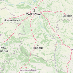
Map view of Ostoja Wierzejska

Use this park location map to pinpoint Ostoja Wierzejska in Poland, understand its exact geographic position, and read its mapped placement within the surrounding landscape more clearly.

Pigeon | © OpenStreetMap contributors

Location context for Ostoja Wierzejska

świętokrzyskie
Recorded earthquake history

Explore the Historical Earthquake Records and Seismic Data for Ostoja Wierzejska

Review a detailed catalogue of historical earthquakes associated with the geography of Ostoja Wierzejska. This MoriAtlas archive organizes recorded seismic activity by distance, allowing for a structured investigation of regional event history and measured physical parameters.

Ostoja Wierzejska Earthquake History

Catalogued events

4 events

Strongest magnitude

Magnitude 3.3

Most recent event

Aug 21, 1996

This history includes earthquakes recorded inside the park or within 50 km of its borders

Explore photographic records of the quartzite ridge, old-growth stands, and valley habitats.

Ostoja Wierzejska Photos and Landscape Scenery: Visualizing the Protected Fir Forest Terrain

Visual documentation reveals the dense canopy structures, rocky slopes, and stream valleys that define Ostoja Wierzejska. Examining photographic evidence helps researchers and visitors interpret the protected forest environment and its unique ecological setting.

A dark forest interior with rays of sunlight piercing through the tree canopy and illuminating the leaf-covered ground.

Park atlas

Compare adjacent forest reserves and mountain landscapes across the Świętokrzyskie region.

Parks Near Ostoja Wierzejska and Protected Areas in the Surrounding Region

Browsing other parks near Ostoja Wierzejska reveals connected forest corridors and protected natural areas across the wider Masłowskie Range. Evaluating adjacent regional topography deepens understanding of local woodland habitats and regional ecological networks.
Protected landscapeŚwiętokrzyskie Voivodeship
5.7 km away#1 closest

Southwest

Chęcińsko-Kielecki Park Krajobrazowy: Protected Landscapes and Geological Atlas

Geographical overview of the Świętokrzyskie foothills in Poland

Located in the Świętokrzyskie Voivodeship, this protected area features a unique concentration of rocky hill summits, limestone caves, and forested corridors. The landscape serves as a vital transition zone, linking the regional capital of Kielce with traditional agricultural valleys and historic cultural landmarks. Map the terrain and understand the protected features that define this significant Polish landscape park.

Area
197.816 km²
Established
1996
Relief
Upland
Climate
Temperate
Protected landscapeŚwiętokrzyskie Voivodeship
8 km away#2 closest

North

Suchedniowsko-Oblęgorski Park Krajobrazowy: A Protected Landscape in Świętokrzyskie

Geographic terrain, forest ecosystems, and industrial heritage

Located in the Świętokrzyskie Voivodeship, this protected area preserves significant forest stands and historic industrial remnants. The terrain captures the intersection of plateau geology and hill country, hosting the headwaters of the Bobrza and Krasna rivers within a culturally layered, heavily forested environment.

Area
198.95 km²
Established
1988
Relief
Mountain
Climate
Temperate
Watercolor illustration of rolling hills with green forests in the foreground and purple, green, pink, and yellow mountain ranges in the background
National parkŚwiętokrzyskie Voivodeship
9.4 km away#3 closest

East

Świętokrzyski National Park: Protected Mountain Terrain in Świętokrzyskie Voivodeship

Geography and landscape mapping for Poland's oldest mountain range

Świętokrzyski National Park encompasses the highest ridges of the Świętokrzyskie Mountains, showcasing a landscape defined by expansive granite boulder fields and primeval fir forests. This atlas entry provides a detailed look at the park's topography, ranging from the prominent Łysica peak to the protected valley floors, highlighting the geological and biological diversity preserved within this central Polish sanctuary.

Area
76.26 km²
Established
1950
IUCN
II
Visitors
168K annual
National parkŚwiętokrzyskie Voivodeship
9.4 km away#4 closest

East

Świętokrzyski Park Narodowy: Protected Forests and Mountain Geography in Central Poland

A preserved landscape of ancient fir forests and rubble fields

Situated within the Świętokrzyskie Voivodeship, this protected area guards the Łysogóry range and its rare forest associations. The landscape is characterized by its dramatic gołoborza rubble fields and dense mixed-woodland terrain, providing a unique look into the natural geography of the region.

Area
76.26 km²
Established
1950
Visitors
168K annual
Relief
Mountain
Nature reserveŚwiętokrzyskie Voivodeship
About 13 km away#5 closest

Southwest

Rezerwat przyrody Moczydło Nature Reserve: Geological and Mining Landscape in Poland

Documenting protected limestone ridges and mining heritage

This protected area safeguards a distinct 317-meter limestone hill that preserves both ancient mining remnants and rare xerothermic grasslands. Located within the Chęcińsko-Kielecki Landscape Park, the site provides a concentrated view of the regional geological identity and industrial past of the Holy Cross Mountains, documented here through its specific mapped boundaries and natural terrain features.

Area
0.164 km²
Established
1995
Relief
Mountain
Scope
Terrestrial
Protected landscapeŚwiętokrzyskie Voivodeship
16 km away#6 closest

Southeast

Cisowsko-Orłowiński Park Krajobrazowy: Protected Landscape and Geological Atlas

Mapping biodiversity and Paleozoic formations in Świętokrzyskie, Poland

Cisowsko-Orłowiński Park Krajobrazowy stands as a center for biodiversity in southeastern Poland, protecting rare peat-bog forests and 200-year-old tree stands. This atlas profile highlights the park's distinct geological character, from the volcanic rock exposures at Sieraków to the fossil-rich sandstone cliffs at Zalesie, offering insight into the complex mosaic of the Góry Świętokrzyskie foothills.

Area
206.93 km²
Established
1988
Relief
Mountain
Climate
Temperate
Protected areaŚwiętokrzyskie Voivodeship
24 km away#7 closest

East

Wzgórza Kunowskie: Geographic Atlas of an Essential Polish Protected Area and Habitat Mosaic

Mapping riparian forests and inland dunes in Świętokrzyskie

Wzgórza Kunowskie serves as a crucial Natura 2000 site in Poland, blending sand grasslands, oak-hornbeam forests, and riverine floodplains within a compact landscape. This overview analyzes the topographical gradients and habitat distribution that define the area, from elevated dunes to the moisture-rich valley floors of the Świętokrzyskie region, reflecting the interplay between sandy substrate and river regulation.

Area
18.687 km²
Water
Major water bodies
Nature reserveświętokrzyskie
About 25 km away#8 closest

West

Rezerwat przyrody Milechowy: Protected Nature Reserve and Karst Landscape Atlas

Exploration of forested ridges and rocky karst terrain in świętokrzyskie, Poland

Rezerwat przyrody Milechowy is a significant nature reserve located in the świętokrzyskie voivodeship, home to diverse ecological habitats ranging from dense woodland ridges to exposed rocky slopes. The area is defined by its karst landscape, featuring multiple caves and rock shelters, alongside rare xerothermic vegetation that flourishes in the warm, sun-exposed terrain of the Holy Cross Mountains region.

Area
1.323 km²
Established
1978
Relief
Upland
Climate
Temperate

Common questions about visiting, size, designation, and location context for Ostoja Wierzejska

Ostoja Wierzejska FAQs for park facts, access, geography, and protected area context

Find quick answers about Ostoja Wierzejska, including protected-area facts, park geography, trail and visitor context, and how the park fits into its surrounding country and regional landscape.
MoriAtlas Explorer

Continue Your Protected Areas Search Across the Global Atlas

Deepen your exploration by continuing the structured search for national parks and protected areas worldwide. Utilize the comprehensive filtering capabilities to compare different conservation landscapes and refine your understanding of global park geography. Discover more about the distribution and characteristics of protected natural areas.

Global natural geography