

Mori Atlas logo
Protected areaOstoja Witnicko-Dębniańska

Discover the geographic boundaries and diverse wetland habitats of the Warta River basin

Ostoja Witnicko-Dębniańska: A Comprehensive Atlas of This Western Polish Protected Landscape

(Ostoja Witnicko-Dębniańska (PLB320015))

Ostoja Witnicko-Dębniańska encompasses nearly 47,000 hectares of vital habitat in western Poland, spanning the northern edge of the Warta river valley. This protected area features a complex mosaic of lowland forests, sphagnum mires, and meandering river systems that support rare bird populations and diverse aquatic ecosystems. Mapping this terrain reveals a transition between glacial moraines and nutrient-rich floodplains, forming a key ecological corridor within the broader landscape of the Lubusz Voivodeship.

Natura 2000Special Protection Areabird sanctuarylowland forestpeat bogsbog and mire
A flat, stylized digital illustration of a cascading waterfall pouring down rocky cliffs into a winding river, surrounded by pine trees and soft pastel-colored clouds.

Ostoja Witnicko-Dębniańska

Protected area

Park overview

Structured park overview, official facts, and landscape profile for Ostoja Witnicko-Dębniańska

Ostoja Witnicko-Dębniańska park facts, protected area profile, and essential visitor context

Review the core facts for Ostoja Witnicko-Dębniańska, including designation, size, terrain, visitor scale, habitats, and operating context in one park-focused overview.

About Ostoja Witnicko-Dębniańska

Ostoja Witnicko-Dębniańska is one of the larger Special Protection Areas in western Poland and forms a key component of the Natura 2000 ecological network in the region. Its designation in 2007 marked a formal recognition of the long-term importance of the area for birds and for the integrity of the broader Warta river valley ecosystem. The sanctuary occupies a transitional zone between the Warta floodplain to the south and the lake districts of the West Pomeranian and South Pomeranian Lakelands to the north, producing a highly varied mosaic of habitats within a relatively compact territory.

Geographically, the area stretches across several municipalities in the Lubuskie and West Pomeranian voivodeships, including the communes of Witnica, Bogdaniec, Lubiszyn, Dębno, Trzcińsko-Zdrój, Chojna, Myślibórz, and Boleszkowice, as well as parts of the city of Gorzów Wielkopolski. The terrain reflects the influence of glacial processes: the southern sections include remnants of the Warta glacial valley, while the northern sections integrate elements of the morainic lake landscape, with managed forests, peat mires, kettle-like depressions, and small dystrophic lakes scattered among the woodlands.

Ecologically, the sanctuary's significance is anchored in its hydrology. The western portion of the area is incised by strongly meandering rivers with numerous oxbows and an extensive network of aquatic and marshy vegetation. These floodplain conditions blend northward into commercial forest stands broken by sphagnum mires, raised bog fragments, and patches of oak-lime-hornbeam forest, warm-loving oak woodland, and beech forest in the southern sections. The resulting habitat gradient supports an unusually high concentration of species requiring large, quiet territories and undisturbed wetlands.

The site's formal protection is multi-layered. In addition to its Natura 2000 status, more than a third of its area overlaps with several protected landscape areas, with the largest share belonging to the Dębno-Gorzów Protected Landscape Area "A". Six nature reserves lie within the sanctuary, including Morenowy Las, Bogdanieckie Grądy, Dębowa Góra, Czapli Ostrów, Długogóry, and Torfowisko Ustronie. Overlapping designations reinforce the area's role as a long-term refuge for sensitive habitats and species, and place it among the more comprehensively protected landscapes in northwestern Poland.

Quick facts and research context for Ostoja Witnicko-Dębniańska

Ostoja Witnicko-Dębniańska is a Natura 2000 Special Protection Area established in 2007, designated primarily for the conservation of birds and their habitats. It straddles the border between the Lubuskie and West Pomeranian voivodeships and lies within the Gorzów Plain and Myślibórz Lake District mesoregions.

The area encompasses large tracts of managed lowland forest interspersed with peat bogs, oxbow lakes, marshland, and floodplain meadows along the Warta river and its tributaries. Six nature reserves and several protected landscape areas overlap with the sanctuary, adding additional layers of formal protection to its most valuable habitats.

Protection and recognition

Documented terrestrial boundaries, management scope, and international network listings.

Ostoja Witnicko-Dębniańska Protection Status and Natura 2000 Recognition

Terrestrial protection status for Ostoja Witnicko-Dębniańska includes verified Natura 2000 framework listings detailing official conservation designations. Structured records compile recognized administrative parameters to support precise geographic analysis of protected natural areas.
Park context

Deeper park guide and search-rich context for Ostoja Witnicko-Dębniańska

Ostoja Witnicko-Dębniańska history, landscape, wildlife, and travel context

Explore Ostoja Witnicko-Dębniańska through its history, landscape character, ecosystems, wildlife, conservation priorities, cultural context, and seasonal travel timing in a structured park guide built for atlas discovery and search intent.

Why Ostoja Witnicko-Dębniańska stands out

The sanctuary is best known for its rich birdlife, especially its breeding populations of large raptors such as white-tailed eagle, black kite, and red kite, and nocturnal species like the eagle owl. It is also recognized for hosting at least 1% of the national breeding population of several of these species, which is the key threshold for identifying internationally important bird areas in Europe. Beyond the birds, the area is valued for its mosaic of lowland forests and peatlands, including raised, transitional, and lowland mires, together with dystrophic and eutrophic lakes that support a distinctive mosaic of wetland habitats. The floodplain edge of the Warta adds another ecological layer, creating a continuous transition between river, marsh, mire, and forest that is increasingly rare in western Poland.
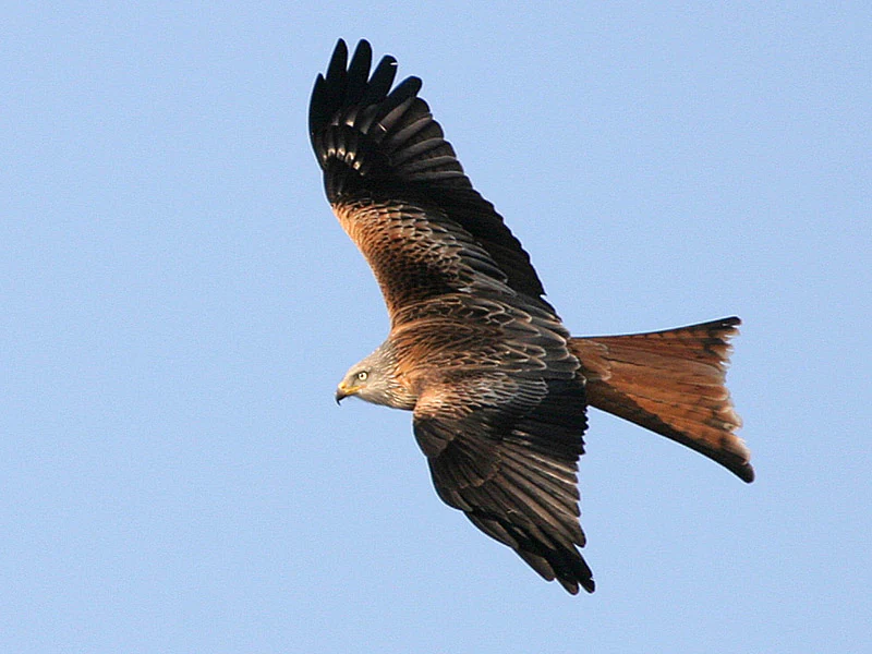
A red kite soaring against a clear blue sky, displaying its distinctive forked tail and patterned reddish-brown plumage.
A red kite in flight over the Ostoja Witnicko-Dębniańska protected area.

Ostoja Witnicko-Dębniańska history and protected-area timeline

Ostoja Witnicko-Dębniańska was formally established as a Special Protection Area in 2007 under the Polish implementation of the European Union Birds Directive. Its designation came as part of a broader wave of Natura 2000 site designations across Poland following the country's accession to the European Union and the subsequent need to identify and protect the most important bird habitats at the national scale.

The recognition built on a longer history of informal conservation in the region. Several of the constituent nature reserves, including Morenowy Las, Bogdanieckie Grądy, Dębowa Góra, Czapli Ostrów, Długogóry, and Torfowisko Ustronie, had been protected individually before the Natura 2000 designation. Over time, the convergence of these reserves with overlapping protected landscape areas created a denser framework of formal protections around the ecological values that the Bird Sanctuary was created to conserve.

Ostoja Witnicko-Dębniańska landscape and geographic character

The landscape of Ostoja Witnicko-Dębniańska is shaped by the meeting of two distinct physical regions: the glacial lowland valley of the Warta river on the southern side, and the morainic lake landscape of the West Pomeranian and South Pomeranian Lakelands to the north. Within the sanctuary, these influences produce a varied topography of forest plains, gently undulating moraines, river terraces, and waterlogged basins.

The southern and central parts of the sanctuary include large commercial forest complexes on the northern edge of the Warta valley, while northward toward Dębno the land opens into the lower valleys of the Myśla and its tributary Kosa. The western side of the area is particularly notable for strongly meandering river sections with small oxbows and a wide belt of aquatic and reed marsh habitats.

Interspersed throughout the forests are peatlands, including sphagnum mires that mark waterlogged depressions, together with dystrophic lakes of brownish, nutrient-poor water and more nutrient-rich eutrophic lakes. In the southern sections, the forests include oak-lime-hornbeam stands, warm-loving oak woods, and patches of beech forest, creating a notable contrast with the wetter, open habitats that dominate elsewhere in the sanctuary.
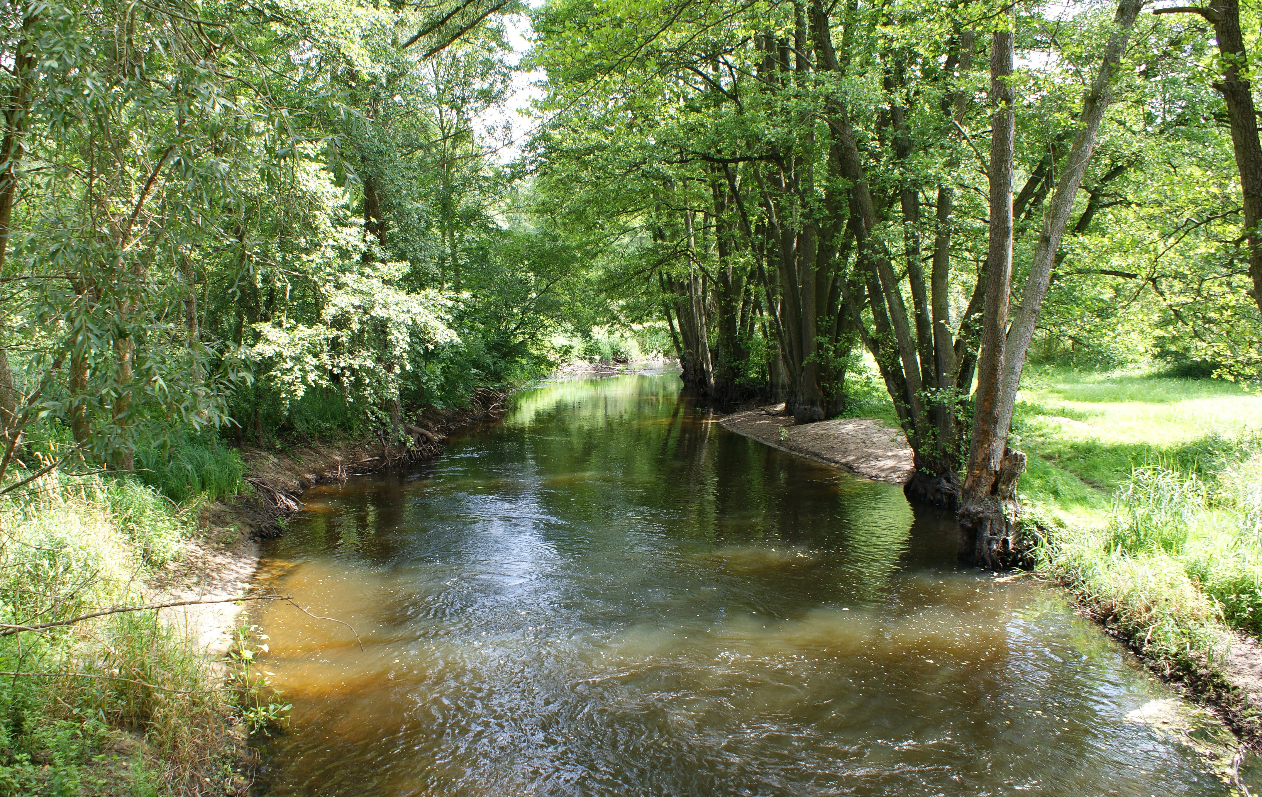
A view of the gently flowing Myśla River surrounded by dense green deciduous forest and grassy banks.
The Myśla River flowing through the forested landscape of Ostoja Witnicko-Dębniańska.

Ostoja Witnicko-Dębniańska ecosystems, habitats, and plant life

The ecological character of Ostoja Witnicko-Dębniańska is defined by a continuous transition between lowland forest, peatland, and river floodplain. The forests include both managed stands of coniferous and mixed woodland and more natural patches of broadleaved forest in the south, where oak, hornbeam, lime, and beech communities create conditions similar to old lowland woodland.

The peatland systems are a central ecological feature. The area includes raised bogs, transitional mires, and lowland fens, many of them dominated by sphagnum mosses. These mires act as water reservoirs, carbon stores, and habitat islands within the broader forest matrix. Their distribution is uneven, often following glacial depressions and the margins of the larger rivers, and they form the wettest and most ecologically distinctive environments in the sanctuary.

Wetland and aquatic habitats are equally prominent. Meandering river sections, oxbow lakes, reed beds, sedge marshes, and small dystrophic and eutrophic lakes together create a persistent wet corridor along the western and southern edges of the area. These wet habitats are not only ecologically rich in themselves but also serve as critical feeding, breeding, and resting grounds for birds and other fauna, including the European pond turtle, which depends on the combination of clean standing water, soft banks, and adjacent open habitat.
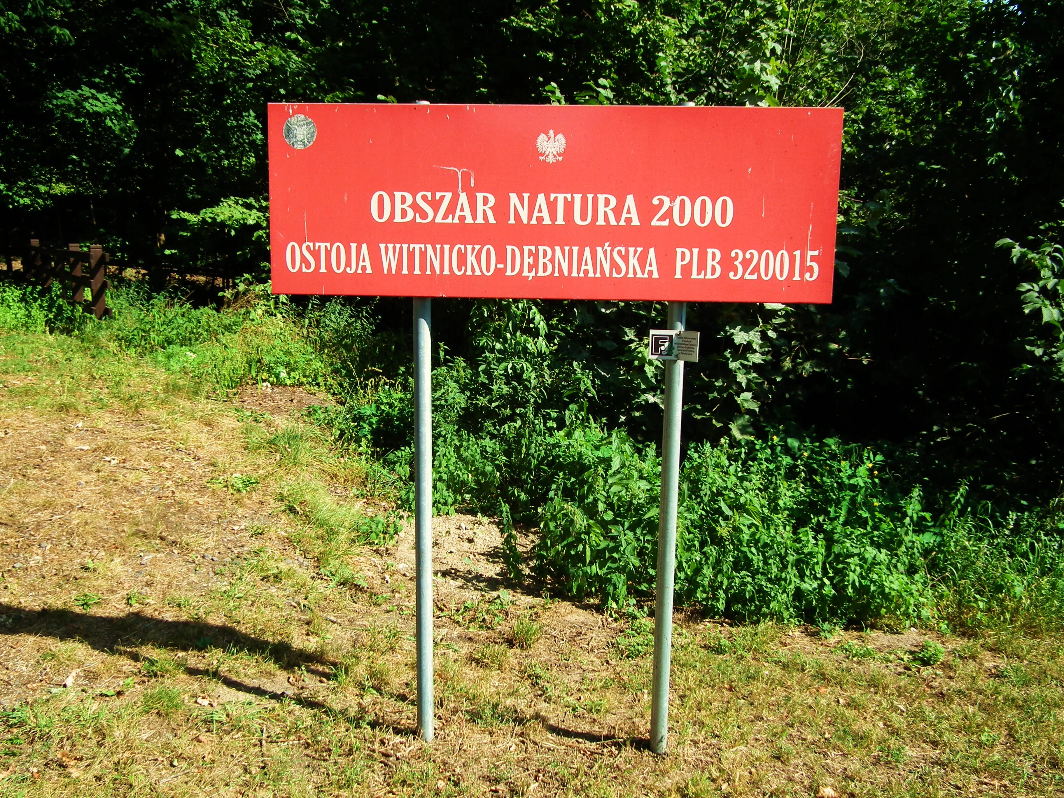
A rectangular red sign with white text on two metal poles reading OBSZAR NATURA 2000 OSTOJA WITNICKO-DĘBNIAŃSKA PLB 320015, set in a forested area.
A Natura 2000 protected area sign marking the Ostoja Witnicko-Dębniańska site.

Ostoja Witnicko-Dębniańska wildlife and species highlights

Wildlife is the central reason for the sanctuary's designation, and birds are by far the most important group. At least 24 species from Annex I of the European Birds Directive are present within Ostoja Witnicko-Dębniańska, including four species listed in the Polish Red Data Book of Animals.

The sanctuary supports breeding populations that, by formal criteria, are internationally important for the country. At least 1% of the Polish breeding population of white-tailed eagle, black kite, red kite, eagle owl, and greylag goose occurs within the area. Other notable species include bittern, little bittern, black stork, white stork, whooper swan, honey buzzard, marsh harrier, hen harrier, lesser spotted eagle, osprey, spotted crake, corncrake, common crane, golden plover, greenshank, common tern, black tern, nightjar, kingfisher, black woodpecker, middle spotted woodpecker, wood lark, barred warbler, red-breasted flycatcher, red-backed shrike, and variable wheatear.

The area also supports a notable population of the European pond turtle, a species that is rare in Poland and strongly dependent on clean, well-vegetated wetland habitats. Among mammals, otter is recorded as present, while the fish fauna includes species such as the weatherfish and the golden spined loach, which depend on the area's slow-moving, well-vegetated waters. The combination of floodplain, forest, and mire also creates favorable conditions for herons, owls, and a wide range of passerines linked to mature broadleaved woodland, especially in the southern parts of the sanctuary.
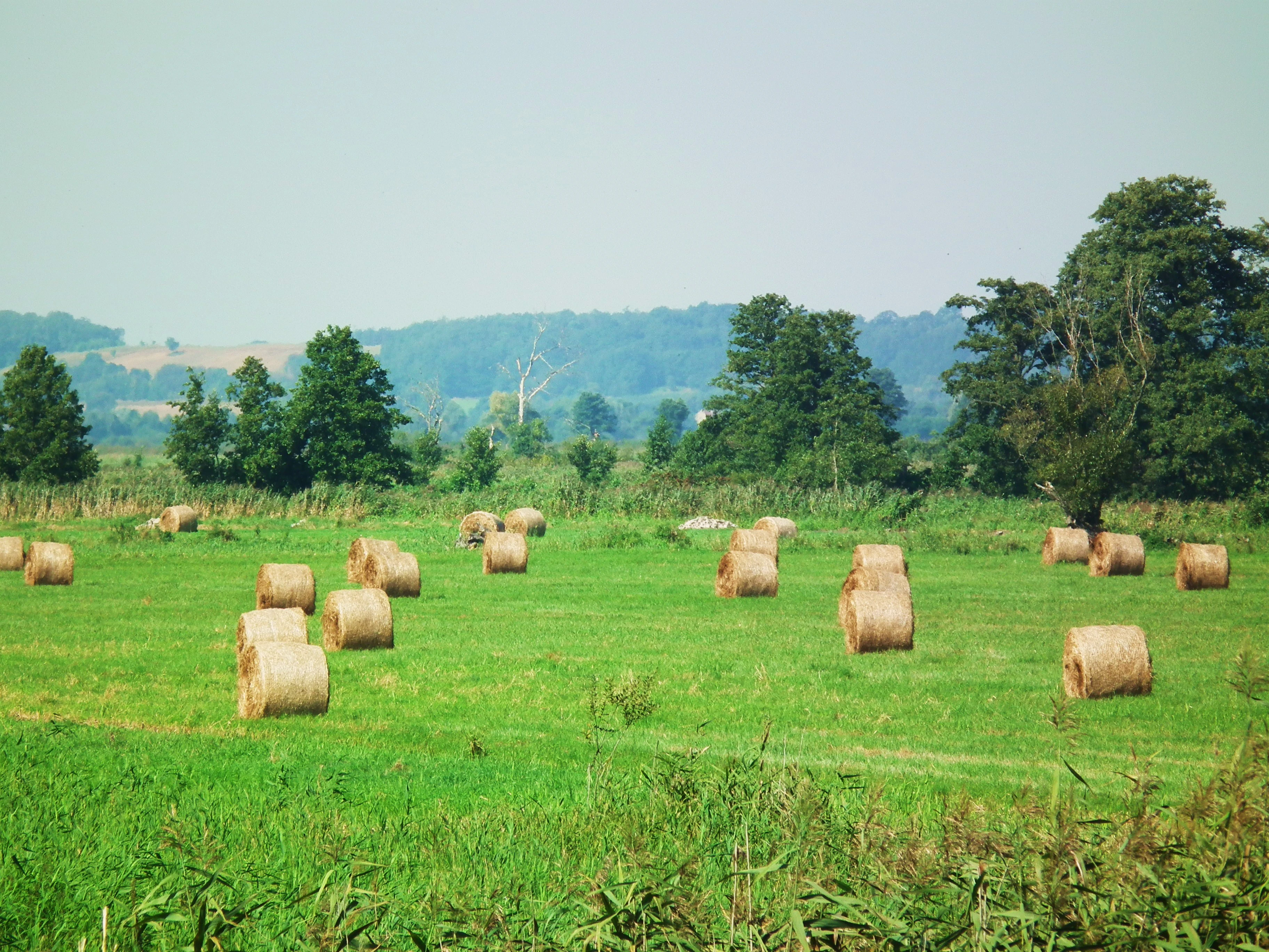
A wide view of a green field dotted with round hay bales, with a line of trees and distant rolling hills in the background under a pale sky.
A pastoral landscape featuring hay bales in a field within the Ostoja Witnicko-Dębniańska region.

Ostoja Witnicko-Dębniańska conservation status and protection priorities

Ostoja Witnicko-Dębniańska is significant from a conservation perspective because it combines multiple threatened habitat types within a single contiguous area. Raised bogs, transitional mires, lowland fens, mature broadleaved forests, and river floodplain wetlands all occur together, making it unusually valuable for landscape-scale habitat protection rather than for any single species or ecosystem alone.

Its bird protection status is the cornerstone of its conservation value. The sanctuary hosts internationally important breeding populations of several raptors and a high diversity of Annex I bird species, placing it among the more important inland bird areas in western Poland. The presence of the European pond turtle adds an additional layer of importance, as this reptile is among the most threatened herpetofauna in the country.

Formal protection is reinforced by six nature reserves within the area and by the overlap of more than one-third of its territory with several protected landscape areas, the largest of which is the Dębno-Gorzów Protected Landscape Area "A". Together, these designations buffer the most sensitive habitats against incompatible land use. At the same time, the site faces recognized threats from forestry, peatland drainage, oil extraction, fisheries and angling, agricultural nutrient runoff, poaching, and trampling of fragile mire vegetation, all of which influence its long-term conservation outlook.

Top sights and standout views in Ostoja Witnicko-Dębniańska

The sanctuary stands out for the unusual concentration within a single lowland area of both extensive peatlands and an internationally important bird assemblage. The combination of managed forest, sphagnum mires, dystrophic lakes, meandering rivers, and riverine floodplains creates a layered ecological landscape in which large raptors, nocturnal birds, wetland specialists, and forest species all find conditions for breeding.

Its proximity to the Błota Nadwarciańskie floodplains and to the city of Gorzów Wielkopolski gives the sanctuary an additional role as a regionally significant landscape feature, visible from the surrounding plains and the edge of the Warta valley. Six nature reserves embedded in the area make it one of the more densely protected landscapes in northwestern Poland, and provide focal points for observing both its habitats and its wildlife.

Best time to visit Ostoja Witnicko-Dębniańska

Spring and early summer are the most rewarding periods for observing the sanctuary's birdlife, when breeding raptors such as white-tailed eagle, black kite, and red kite are active on their territories and species such as bittern, marsh harrier, and corncrake are most easily detected in the wetlands and meadows.

Late winter and early spring can also be rewarding around the river floodplains and open wetland edges, when migratory waterfowl and early-returning cranes are present. Autumn brings migration movements through the area, while the strongly waterlogged character of the mires and floodplains means that many parts of the sanctuary remain ecologically interesting throughout the year, particularly for observers interested in mire vegetation, wetland landscapes, and mature lowland forest.


Monthly climate preview

Long-term temperature ranges and monthly precipitation averages for Ostoja Witnicko-Dębniańska

Ostoja Witnicko-Dębniańska Climate Normals and Annual Weather Patterns

Representative coordinate records outline sustained winter cooling and warm summer maximums alongside steady monthly precipitation distribution across the protected landscape. Detailed multi-year climatology data provides complete month-by-month temperature baselines and precipitation statistics for thorough geographical research.
Annual mean9 °C
-1 °C19 °C
Jan-1°
Feb
Mar
Apr
May13°
Jun17°
Jul19°
Aug19°
Sep14°
Oct
Nov
Dec
Warmest month
July

19.3 °C

Coolest month
January

-1.5 °C

Wettest month
July

2.5 mm/day

Driest month
April

1.2 mm/day

Park location guide

Geography guide, regional context, and park location map for Ostoja Witnicko-Dębniańska

Ostoja Witnicko-Dębniańska park geography, regions, and map view in Poland

Understand where Ostoja Witnicko-Dębniańska sits in Poland through a broader geographic reading of the surrounding landscape, nearby location context, and its mapped position within the national park landscape.

How Ostoja Witnicko-Dębniańska fits into Poland

Poland, officially the Republic of Poland, is a Central European country spanning from the Baltic Sea in the north to the Carpathian Mountains in the south. It borders Germany, Czech Republic, Slovakia, Ukraine, Belarus, Lithuania, and Kaliningrad Oblast. The country has a temperate climate, diverse landscapes, and is known for its rich history, cultural heritage, and strong economic position within the EU.

Wider geography shaping Ostoja Witnicko-Dębniańska in Poland

Poland occupies 312,696 km2 in Central Europe, extending from the Baltic Sea coast in the north to the Sudetes and Carpathian Mountains in the south. It borders Germany to the west, Czech Republic and Slovakia to the south, Ukraine and Belarus to the east, and Lithuania and Kaliningrad Oblast to the northeast. The landscape includes lowland plains, uplands, and mountain ranges.

Map view of Ostoja Witnicko-Dębniańska

Use this park location map to pinpoint Ostoja Witnicko-Dębniańska in Poland, understand its exact geographic position, and read its mapped placement within the surrounding landscape more clearly.

Pigeon | © OpenStreetMap contributors

Location context for Ostoja Witnicko-Dębniańska

Lubusz VoivodeshipWest Pomeranian Voivodeship

Visual exploration of lowland forests, sphagnum mires, and river floodplains.

Ostoja Witnicko-Dębniańska Photos and Landscape Scenery

Examine detailed visual documentation of Ostoja Witnicko-Dębniańska to understand its complex mosaic of glacial valleys, peatlands, and protected wetland habitats. Photographic records capture the distinct terrain, vegetation patterns, and physical character of this western Polish sanctuary.

A red kite soaring against a clear blue sky, displaying its distinctive forked tail and patterned reddish-brown plumage.

A side view of a European pond turtle perched on a fallen log above dark water, showing a clear reflection of the turtle's shell and head.

A view of the gently flowing Myśla River surrounded by dense green deciduous forest and grassy banks.

A rectangular red sign with white text on two metal poles reading OBSZAR NATURA 2000 OSTOJA WITNICKO-DĘBNIAŃSKA PLB 320015, set in a forested area.

A wide view of a green field dotted with round hay bales, with a line of trees and distant rolling hills in the background under a pale sky.

Park atlas

Compare adjacent wetland reserves, river valleys, and regional lowland ecosystems

Parks Near Ostoja Witnicko-Dębniańska and Surrounding Protected Landscapes

Browsing other protected areas near Ostoja Witnicko-Dębniańska reveals connected lowland forests, peat mires, and river floodplains across the surrounding region. Expanding the geographic comparison helps trace regional wildlife corridors and shared wetland habitats beyond a single sanctuary.
Nature reserveLubusz Voivodeship
Mapped location lies within the park boundary#1 closest

East

Rezerwat przyrody Dębowa Góra: Protected Oak and Beech Woodland Geography in Lubusz Voivodeship

Analysis of a near-natural deciduous forest reserve in western Poland.

Rezerwat przyrody Dębowa Góra is a protected fragment of mature deciduous woodland located in Gorzów County. Its landscape preserves essential oak-lime-hornbeam forest stands, providing a glimpse into the natural lowland ecology of the Lubusz Voivodeship through structured active conservation and forest management.

Area
0.113 km²
Established
1995
Relief
Lowland
Climate
Temperate
National parkLubusz Voivodeship
1.3 km away#2 closest

South

Park Narodowy „Ujście Warty” National Park: Regional Geography and Wetland Landscapes

A major protected riparian and floodplain zone in western Poland

Located in the Lubusz Voivodeship, Park Narodowy „Ujście Warty” features an extensive network of wetlands, marshes, and meadows at the Warta and Oder confluence. This atlas entry provides essential geographic context for the park's lowland terrain and riverine ecosystems, which are defined by constant shifts in water levels and seasonal flooding patterns that sustain dense bird populations.

Area
80.74 km²
Established
2001
Visitors
52K annual
Relief
Lowland
Watercolor illustration showing a river winding through rolling green hills with sparse vegetation
National parkLubusz Voivodeship
1.3 km away#3 closest

South

Warta Mouth National Park: A National Park Protecting Vital European Wetlands

Explore mapped protected areas and bird habitats in Lubusz Voivodeship.

Warta Mouth National Park, located in Poland's Lubusz Voivodeship, is a significant protected landscape safeguarding the ecologically rich confluence of the Warta and Oder rivers. As the nation's most recently established national park, it provides critical habitat for a vast array of migratory and breeding bird species within its extensive marshlands and floodplains. This park offers a unique opportunity for atlas-driven exploration of Central European wetland geography and the mapped boundaries of a vital conservation area.

Area
80.38 km²
Established
2001
IUCN
II
Visitors
52K annual
Protected landscapePoland
1.4 km away#4 closest

Southwest

Park Krajobrazowy Ujście Warty: Protected Landscape and River Valley Atlas

Mapping wetland ecosystems and floodplain geography in western Poland

Park Krajobrazowy Ujście Warty preserves a significant lowland river valley landscape characterized by vast open pastures, marshes, and rare riparian oak forests. Located primarily within the Lubuskie region, this protected area offers a clear view into the floodplain processes of the Warta river basin, providing a distinct geographic context for wetland conservation and waterbird habitat mapping in Poland.

Area
194.96 km²
Established
1996
Relief
Lowland
Climate
Temperate
Protected landscapeWest Pomeranian Voivodeship
7.2 km away#5 closest

Northwest

Cedynia Landscape Park: Mapped Protected Landscapes and Regional Geography in Poland

Protected mosaic of sandy forests and river valleys

Spanning 308 square kilometers, Cedynia Landscape Park protects a complex transition zone in Poland. The area features the expansive Puszcza Piaskowa pine forests, the hilly moraine relief of the Cedynia Carpathians, and the biodiverse wetlands of the lower Oder River. This protected landscape represents an essential study in lowland ecological gradients and postglacial terrain development within the West Pomeranian Voivodeship.

Area
308.5 km²
Established
1993
Relief
Upland
Climate
Temperate
A horizontal watercolor painting showing a calm body of water in the foreground with gentle rolling hills and light vegetation in the background under a soft golden sky.
Protected landscapeZachodniopomorskie
7.6 km away#6 closest

Northeast

Barlinecko-Gorzowski Park Krajobrazowy: Protected Landscape and Glacial Geography

A study of forest complexes and postglacial lake systems in Poland

Covering vast stretches of the Puszcza Barlinecka, this protected landscape is characterized by its sandr substrate, seventy-five distinct lake basins, and intricate peatland ecosystems. The region provides a deep look into the glacial history of Northwestern Poland and its unique mix of coniferous forests and moisture-rich hollows.

Area
239.83 km²
Established
1991
Relief
Lowland
Climate
Temperate
Nature reserveLubusz Voivodeship
About 10 km away#7 closest

East

Dębina Nature Reserve: An Oak-Hornbeam Woodland Sanctuary in Lubusz Voivodeship

Mapping the ecological heritage of Poland's lowland forest remnants

Dębina protects a compact, authentic fragment of deciduous forest, characterized by a mix of mature oak, hornbeam, and linden. This site acts as a living ecological reference point for the Równina Gorzowska region, showcasing the vertical stratification and ground-layer flora typical of undisturbed oak-hornbeam habitats. Access the geographic context and conservation data to better understand how this managed reserve preserves the woodland legacy of western Poland.

Area
0.122 km²
Established
1995
Relief
Lowland
Climate
Temperate
Nature reserveLubusz Voivodeship
About 12 km away#8 closest

South

Dolina Postomii Nature Reserve: Geography, Protected Forests, and River Valley Mapping

Mapping the protected landscapes of Lubusz Voivodeship

Dolina Postomii Nature Reserve is a significant protected area situated within the river-focused geography of western Poland. The reserve preserves a distinct mosaic of oak-hornbeam forests, acidophilous woodlands, and rich floodplain meadows. This compact landscape offers a window into the natural ecological transition between higher forested terraces and the wetland floor, providing essential habitats for breeding birds and rare beetles within the regional Warta basin.

Area
0.687 km²
Established
2005
Relief
Lowland
Scope
Terrestrial

Common questions about visiting, size, designation, and location context for Ostoja Witnicko-Dębniańska

Ostoja Witnicko-Dębniańska FAQs for park facts, access, geography, and protected area context

Find quick answers about Ostoja Witnicko-Dębniańska, including protected-area facts, park geography, trail and visitor context, and how the park fits into its surrounding country and regional landscape.
MoriAtlas Explorer

Continue Your Protected Areas Search Across the Global Atlas

Deepen your exploration by continuing the structured search for national parks and protected areas worldwide. Utilize the comprehensive filtering capabilities to compare different conservation landscapes and refine your understanding of global park geography. Discover more about the distribution and characteristics of protected natural areas.

Global natural geography