
Mori Atlas logo
Protected landscapeOwen

A structured geographic survey of protected terrain across the Mittleres Albvorland regional boundary

Owen Protected Landscape: Mapping the Orchard Meadow Mosaic and Teckberg Slopes of Baden-Württemberg

(Landschaftsschutzgebiet „Owen“)

The Owen protected landscape spans 567 hectares across the Esslingen district, marking a significant transitional zone between the fertile lowlands and the Swabian Alb. This atlas entry details the internal geography of the site, including its characteristic orchard meadows, drystone walls, and the wooded slopes of the Teckberg. By mapping these key features, the data provides a comprehensive overview of the agricultural heritage and topographical relief that define this essential countryside reserve.

orchard meadowsStreuobstwiesenAlb forelandSwabian Albprotected landscapehedgerows
A graphic illustration showing a mountain range with a cascading waterfall flowing into a river, framed by foliage in the foreground under a pale sky.

Owen

Protected landscape

Park overview

Structured park overview, official facts, and landscape profile for Landscape Protection Area Owen

Landscape Protection Area Owen park facts, protected area profile, and essential visitor context

Review the core facts for Landscape Protection Area Owen, including designation, size, terrain, visitor scale, habitats, and operating context in one park-focused overview.

About Landscape Protection Area Owen

Landscape Protection Area Owen is one of many countryside reserves that together shape the rural character of the district of Esslingen. It lies west of the town of Owen in the Mittleres Albvorland, the broad transition zone where the lowlands of the Neckar basin give way to the cuesta landscape of the Swabian Alb. Within this zone, the reserve preserves a particularly complete example of the mosaic land use that has long defined the region: small-scale agriculture, traditional orchard cultivation, woodland fragments, and varied linear habitats.

The protected area comprises two main sections. The larger section occupies the western part of Owen's municipal territory, bounded by the district boundaries of Dettingen unter Teck and Beuren, the edge of the Erkenbrechtsweiler Berghalbinsel landscape reserve, and the boundary of Unterlenningen-Brucken. The second section covers the portion of the Teckberg that belongs to Owen, giving the reserve a vertical reach that connects valley-floor farmland with the wooded slope of one of the Alb's most recognisable landmarks.

Administratively, the reserve is managed by the Landratsamt Esslingen and catalogued under German protected-area number 1.16.049. Its designation reflects the dual character of such Swabian countryside reserves: they are places where ecological structures, cultural land use, and the recreational needs of nearby urban populations all intersect. In Owen's case, protection aims explicitly at preserving a close-to-nature cultural landscape while also keeping it accessible as Naherholungsgebiet, or near-home recreation area, on the edge of the Stuttgart/Neckar region.

Quick facts and research context for Landscape Protection Area Owen

The reserve is administered by the Landratsamt Esslingen and falls under IUCN Management Category V (Protected Landscape/Seascape). Its official identifier in the German protected-area register is 1.16.049, and it corresponds to World Database on Protected Areas entry 323605.

Two protected-area orders are relevant to its current boundaries: the original designation by the Landratsamt Esslingen on 5 June 1974, and a 1999 amendment that reduced the area by about 105 hectares when the adjoining Teck nature reserve was formally designated. Earlier local orders from the former Landkreis Nürtingen covering the Tiefenbachtal and broader landscape elements ceased to apply within the current boundary at that time.

Protection and recognition

Examine the documented conservation framework and international recognition data for Owen.

Owen Protection Status and Official Protected Area Designation Records

Protected area records for Owen assemble official designation details and international recognition frameworks into a single verified conservation profile. Reference data outlines the documented status and management context associated with the protected landscape.

Protection details

WDPA ID
323605
Park context

Deeper park guide and search-rich context for Landscape Protection Area Owen

Landscape Protection Area Owen history, landscape, wildlife, and travel context

Explore Landscape Protection Area Owen through its history, landscape character, ecosystems, wildlife, conservation priorities, cultural context, and seasonal travel timing in a structured park guide built for atlas discovery and search intent.

Why Landscape Protection Area Owen stands out

Landscape Protection Area Owen is particularly valued for its extensive, richly structured orchard meadows (Streuobstwiesen) and the network of small habitat features that surrounds them: grassy and gravel tracks, drystone walls, lean grassy strips, field margins, hedges, field copses, near-natural woodland, and moist spring seepage zones. The reserve is also distinguished by its position at the foot of the Teckberg, where the gentle Alb foreland rises toward the wooded, prominent Teck slope and the neighbouring Erkenbrechtsweiler Berghalbinsel with Hörnle and Jusi. This setting gives the protected area both agricultural cultural heritage and a strong scenic-geological edge.
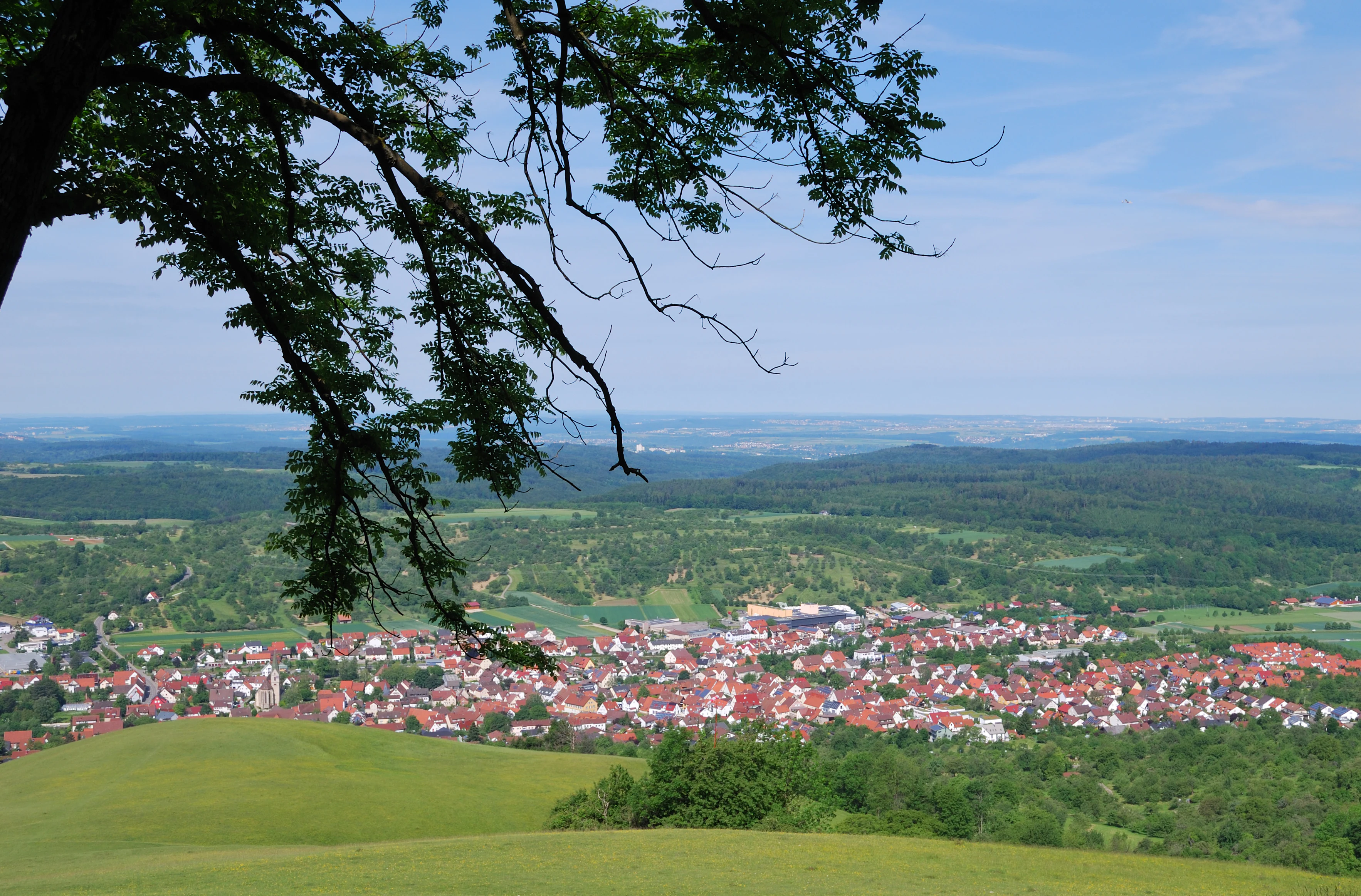
An elevated, wide-angle view overlooking a town with red-roofed houses in a valley, framed by a tree branch in the foreground, with rolling green hills and a forested horizon.
A panoramic view of the town of Owen nestled in the landscape, as seen from the slopes of the Swabian Jura.

Landscape Protection Area Owen history and protected-area timeline

The Landscape Protection Area Owen was established by order of the Landratsamt Esslingen on 5 June 1974. Its initial extent covered roughly 567 hectares across two parcels, anchoring the protection of the western Owen countryside and the Owen share of the Teckberg into a single administrative framework.

Earlier protection efforts existed in the region but in a fragmented form. Orders from the former Landkreis Nürtingen had protected parts of the landscape since 1940 and 1942, including the Tiefenbachtal and a broader set of landscape elements and features. These older orders lost effect within Owen's territory once the unified 1974 reserve was in place, although the dry-structures habitat logic they represented continued under the new designation.

The reserve's boundaries changed significantly on 9 November 1999, when, in conjunction with the designation of the Teck nature reserve (Naturschutzgebiet Teck), about 105 hectares were removed from the landscape protection area. The shift reflected a growing desire to manage the most ecologically sensitive Teckberg slopes under stricter natural-reserve rules, while the remaining landscape protection area continued to focus on the orchard-meadow mosaic and the broader recreational landscape.

Landscape Protection Area Owen landscape and geographic character

The reserve sits at the interface of two classic Swabian landform zones. At its base lies the gently undulating Alb foreland, with shallow valleys, fielded slopes, and broad strips of farmland. This foreland is no flat plain; rather, it tilts gradually upward toward the Alb edge, producing a landscape of long sightlines, deep-cut stream channels, and repeating field patterns framed by hedges and tree lines.

Above and behind Owen rises the Teckberg, with the reserve including the Owen portion of this wooded volcanic-composite peak. The Teckberg gives the protected area a sharp topographical signature: a single, prominent hill above a sea of orchard meadows and field copses. To the north, the landscape is continuous with the Erkenbrechtsweiler Berghalbinsel and the Hörnle and Jusi heights, creating an interconnected high-ground counterpart to the valley-floor mosaic.

The local landforms include kettle-shaped slope depressions, hedge-topped terrace edges, spring seepage lines, and the dry-stone-walled boundaries that follow centuries-old field divisions. Gravel and grass tracks, mageren Wiesen (nutrient-poor grasslands), and lean rain strips interrupt the orchard matrix, producing the fine-grained relief that defines the area visually.

Landscape Protection Area Owen ecosystems, habitats, and plant life

Orchard meadows form the ecological heart of the reserve. These are not monoculture orchards but extensive, traditionally managed Streuobstwiesen, where tall fruit trees of different ages stand above species-rich grassland. Over decades, this combination has become a habitat in its own right, supporting insects, cavity-nesting birds, bats, and small mammals while also maintaining open, sun-exposed ground flora.

Interlocking with the meadows is a deliberate catalogue of supporting habitats: Hangkanten (slope edges) and dry embankments, lean and dry field margins, fallow strips, hedges, and field copses. Drystone walls are protected both as cultural features and as habitat providers, offering shelter and microclimate for reptiles, invertebrates, and rare plants.

Moister elements balance the dry structure. Small unused patches, near-natural woodland remnants, and especially spring seepage zones (feuchte Quellbereiche) along the Alb edge contribute damp-loving vegetation and act as ecological stepping stones. In the natural-region classification, this whole mosaic falls within unit 101 Mittleres Albvorland, part of the broader 10 Schwäbisches Keuper-Lias-Land, a setting defined by alternating marl, sandstone, and limestone-influenced soils.

Landscape Protection Area Owen wildlife and species highlights

While the source material does not catalogue individual species, the structural design of the reserve makes its wildlife values predictable and ecologically significant. Orchard meadows with old fruit trees support breeding populations of woodland-edge birds, owls, and hole-nesting species; hedges and field copses shelter small mammals and provide bird song lines across the meadow matrix.

Spring zones and moist fringes support amphibians, dragonflies, and damp-loving invertebrate communities that depend on the continuous presence of small seepage patches. Drystone walls and lean grassy margins favour warmth-loving invertebrates, reptiles, and pollinator groups that have retreated from more intensively farmed countryside nearby.

The wooded portion of the Teckberg belonging to Owen adds a different wildlife register: forest birds, bats using tree cavities, and the broader mammal communities associated with near-natural deciduous and mixed forest stands on the Alb edge.

Landscape Protection Area Owen conservation status and protection priorities

The protection order for Owen recognises the area as being of supra-local importance for the natural balance of the Alb foreland. The central conservation goal is the preservation of the richly structured orchard meadows and their associated small-scale features: slope edges, lean strips, drystone walls, fallows, hedges, field copses, near-natural woodland, forest edges, and spring seepage areas.

Critically, the reserve is not managed as a strict nature reserve but as a working cultural landscape. Its conservation logic assumes continued low-intensity land use, including traditional orchard management and low-input meadow farming, on which the existing habitat mosaic depends. The 1999 boundary adjustment shifted the most ecologically sensitive Teckberg section into a stricter Naturschutzgebiet, allowing the remaining landscape protection area to focus on the broader mosaic and the recreational function of the countryside.

The reserve also serves as a green buffer on the western edge of the middle Neckar metropolitan area, protecting landscape continuity between the urban region and the more strictly protected slopes of the Swabian Alb.

Landscape Protection Area Owen cultural meaning and human context

The reserve sits within a deeply rooted Swabian farming tradition. Standard-, Hoch- and other traditional orchard forms characterize the area, and the dry-stone walls, hedge boundaries, and small field tracks preserve land-use patterns whose origins stretch back centuries. The town of Owen itself, visible from much of the reserve, has a historic identity closely tied to the surrounding agricultural land.

The protection status reflects a regional cultural value placed on open orchard landscapes as part of Swabian identity, with Streuobstwiesen functioning simultaneously as food-producing land, ecological habitat, and an element of regional scenery. Management under the Landratsamt Esslingen, combined with the longstanding recreational use of the area, embeds the reserve in everyday life for nearby communities.

Top sights and standout views in Landscape Protection Area Owen

The reserve's signature feature is its extensive and richly structured orchard-meadow mosaic, surrounded by stone walls, hedges, and field copses that together act as both habitat and cultural heritage.

The Teckberg edge provides a striking topographical contrast: cultivated meadow landscape below, forested slope and the iconic Teck peak above, with the reserve spanning both elevations. The position astride the Mittleres Albvorland gives it a direct bridge function between the populous Neckar lowlands and the higher, more strictly protected Swabian Alb.

Best time to visit Landscape Protection Area Owen

Spring, when orchard meadows come into bloom and traditional fruit trees flower above fresh grass, is widely considered a visually rich time in the Alb foreland. Late spring and early summer also bring the highest insect and bird activity across hedges and field copses.

Autumn offers a different appeal, with harvest activity in the orchards and changing colours across the meadows, woodland edges, and the Teckberg slope. Winters tend to be quieter, with clearer views toward the Teckberg and the surrounding Alb edge, although weather conditions on the Alb foreland can be damp.

Monthly climate preview

Long-term representative records for average temperature and monthly precipitation patterns

Owen Climate Normals, Annual Temperature and Monthly Precipitation Preview

Measured coordinates for Owen reveal a sustained annual rhythm of low winter temperatures and higher summer warmth alongside consistent precipitation rates. Detailed monthly comparisons illustrate the full range of historical climate normals across the protected area.
Annual mean8 °C
-1 °C18 °C
Jan-1°
Feb
Mar
Apr
May13°
Jun16°
Jul18°
Aug18°
Sep14°
Oct
Nov
Dec
Warmest month
July

18.2 °C

Coolest month
January

-1.1 °C

Wettest month
July

3.2 mm/day

Driest month
February

1.7 mm/day

Park location guide

Geography guide, regional context, and park location map for Landscape Protection Area Owen

Landscape Protection Area Owen park geography, regions, and map view in Germany

Understand where Landscape Protection Area Owen sits in Germany through a broader geographic reading of the surrounding landscape, nearby location context, and its mapped position within the national park landscape.

How Landscape Protection Area Owen fits into Germany

Germany is a federal republic in Western and Central Europe with a population of over 83 million across sixteen constituent states. It is Europe's largest economy by nominal GDP and a major global exporter and importer. The capital is Berlin, and the country borders Denmark, Poland, Czech Republic, Austria, Switzerland, France, Luxembourg, Belgium, and the Netherlands.

Wider geography shaping Landscape Protection Area Owen in Germany

Germany is located in Western and Central Europe, spanning 357,022 km². It borders Denmark to the north, Poland and the Czech Republic to the east, Austria and Switzerland to the south, and France, Luxembourg, Belgium, and the Netherlands to the west. The country has coastlines on the Baltic Sea and North Sea to the north, with the Alps located in the southern region.

Map view of Landscape Protection Area Owen

Use this park location map to pinpoint Landscape Protection Area Owen in Germany, understand its exact geographic position, and read its mapped placement within the surrounding landscape more clearly.

Pigeon | © OpenStreetMap contributors

Location context for Landscape Protection Area Owen

Baden-Württemberg

Explore the terrain, orchard meadows, and Teckberg slope characteristics of Owen through detailed protected area imagery.

Owen Photos and Landscape Scenery: Visualizing the Protected Area

Visual documentation reveals the intricate orchard meadows and sloping terrain that define the protected landscape around Owen. Examining these photographs provides clearer insight into the transitional habitats and topographical contrasts of the Swabian Alb foreland.

An elevated, wide-angle view overlooking a town with red-roofed houses in a valley, framed by a tree branch in the foreground, with rolling green hills and a forested horizon.

Park atlas

Compare regional geography and connected reserves across the Swabian Alb foreland

Explore Other Parks Near Owen and Surrounding Protected Landscapes

Browsing other protected areas near Owen reveals the broader topographical transition between the Neckar lowlands and the Swabian Alb. Comparing these neighboring reserves highlights shared orchard mosaics, wooded slopes, and regional landform patterns.
Protected landscapeBaden-Württemberg
About 2.6 km away#1 closest

Northwest

Tiefenbachtal Protected Landscape: Geographic Boundaries and Regional Terrain Map

Swabian Alb foothill mosaic in the Esslingen district

Investigate the protected landscape of Tiefenbachtal, where gently rolling terrain and stream-cut valleys form a continuous ecological corridor. This record covers the physical geography, meadow and woodland composition, and the broader context of this site within the Baden-Württemberg pre-Alb landscape.

Area
0.35 km²
Established
1958
IUCN
V
Relief
Upland
Protected landscapeBaden-Württemberg
About 6.8 km away#2 closest

Southwest

Neuffen auf Gemarkungen Neuffen und Kappishäusern Protected Area and Regional Landscape

Geography of the Swabian Alb escarpment and riparian zones

This protected landscape defines the visual and ecological character of the area surrounding the Hohenneuffen and Jusi hills. The terrain spans limestone slopes, fruit-bearing orchards, and the Steinach river valley. By integrating local habitat protection with regional biosphere networks, the region serves as a vital transition point between the plateau and the Neckar basin.

Area
13.41 km²
Established
1993
IUCN
V
Relief
Mountain
Protected landscapeBaden-Württemberg
About 8.8 km away#3 closest

North

Wendlingen am Neckar Protected Landscape: Regional Geography and Habitat Connectivity

A structured Swabian countryside mosaic in Baden-Württemberg

This protected area safeguards a unique, fragmented landscape comprising traditional orchard meadows and brookside woodland corridors. Located on the Filder plateau, it acts as a critical ecological refuge, maintaining the transition between settled zones and the natural terrain of the Mittleres Albvorland through long-standing landscape conservation measures.

Area
2.27 km²
Established
1992
IUCN
V
A minimalist watercolor painting depicting a soft-focus landscape with rolling hills, distant ridgelines, and scattered trees across a meadow, rendered in muted greens, purples, and pinks on a white background.
Protected landscapeBaden-Württemberg
About 9.5 km away#4 closest

Northeast

Ohmden-Holzmaden Protected Landscape: Swabian Alb Foothill Mapping

A diverse mosaic of traditional orchards and stream valleys

Ohmden-Holzmaden encompasses a vital protected landscape in the Esslingen district, defined by the Trinkbach, Seebach, and Aubach valleys. This geography of traditional orchards, meadows, and hedgerows maintains an open, structured rural habitat that serves as a critical refuge within the broader Swabian Alb foothill region of Germany.

Area
3.111 km²
Established
1993
IUCN
V
Relief
Upland
Protected landscapeBaden-Württemberg
About 10 km away#5 closest

East

Weilheim an der Teck auf Gemarkungen Weilheim und Hepsisau Protected Landscape Atlas

Volcanic hill geography in the Baden-Württemberg region

This protected area safeguards a richly structured landscape where rolling foothills meet the steep escarpments of the Swabian Alb. Centered on the volcanic peaks of Limburg and Egelsberg, the region maintains a vital balance between forest corridors and open agricultural plains within the district of Esslingen.

Area
13.615 km²
Established
1979
IUCN
V
Protected landscapeBaden-Württemberg
About 10 km away#6 closest

Northeast

Notzingen Protected Landscape: Mapping the Voralb Foothills and Swabian Alb Terrain

Regional protected area analysis in Landkreis Esslingen

Notzingen represents a coherent protected landscape composed of three parcels near the Swabian Alb foothills. The area is defined by a delicate intersection of stream-side riparian habitats and traditional Streuobstwiesen orchard meadows. This atlas-focused entry provides spatial context for understanding how these protected lands maintain the character of the southern German countryside.

Area
3.15 km²
Established
1989
IUCN
V
Relief
Upland
A soft watercolor painting depicting rolling green hills and meadows against a white background.
Protected landscapeBaden-Württemberg
About 11 km away#7 closest

East

Neidlinger Tal Protected Landscape: Regional Geography and Mapped Boundaries

A study of the Swabian Alb and Alb foreland transition terrain

The Neidlinger Tal protected landscape represents a vital intersection of natural regions in Baden-Württemberg. Its boundaries encompass a mosaic of forest and farmland, providing a comprehensive look at how historical land use patterns coexist with modern conservation efforts within the Swabian Alb, including various bird and habitat protection designations.

Area
10.959 km²
Established
1975
IUCN
V
Relief
Upland
Protected landscapeLandkreis Esslingen
About 13 km away#8 closest

North

Wernau (Neckar) Protected Landscape: Geographic Overview and Mapped Cultural Terrain

Landscape protection area within the Landkreis Esslingen region

Trace the boundaries of the Wernau (Neckar) protected landscape, an ecologically significant mosaic of meadow orchards, riparian vegetation, and small woodlands. Situated in the Landkreis Esslingen of Baden-Württemberg, this area functions as a critical buffer zone that maintains the continuity of local habitats between the Filder plain and the Swabian Alb foothills.

Area
2.27 km²
Established
1995
IUCN
V

Common questions about visiting, size, designation, and location context for Landscape Protection Area Owen

Landscape Protection Area Owen FAQs for park facts, access, geography, and protected area context

Find quick answers about Landscape Protection Area Owen, including protected-area facts, park geography, trail and visitor context, and how the park fits into its surrounding country and regional landscape.
MoriAtlas Explorer

Continue Your Protected Areas Search Across the Global Atlas

Deepen your exploration by continuing the structured search for national parks and protected areas worldwide. Utilize the comprehensive filtering capabilities to compare different conservation landscapes and refine your understanding of global park geography. Discover more about the distribution and characteristics of protected natural areas.

Global natural geography