
Mori Atlas logo
State or regional parkParc naturel départemental du Vinaigrier

Mapping the ecological boundaries and terraced landscapes of this Nice hinterland reserve

Parc naturel départemental du Vinaigrier: A Protected Mediterranean Limestone Hillside

Parc naturel départemental du Vinaigrier stands as a vital protected area on the limestone slopes of Mont Vinaigrier, overlooking the Bay of Nice. This compact 25 hectare site features a distinct calcareous plateau, historical agricultural terraces, and a diverse forest transition between Aleppo pines, holm oaks, and flowering ash. The protected landscape serves as a crucial urban fringe wildlife refuge, providing habitat for migratory birds and small mammals.

Mediterranean woodlandlimestone plateauAleppo pine forestholm oakflowering ash foresturban-adjacent nature reserve
A flat-style digital illustration depicting a rocky mountain peak and a waterfall flowing into a river, surrounded by stylized trees under a sky with clouds.

Parc naturel départemental du Vinaigrier

State or regional park

Park overview

Structured park overview, official facts, and landscape profile for Parc naturel départemental du Vinaigrier

Parc naturel départemental du Vinaigrier park facts, protected area profile, and essential visitor context

Review the core facts for Parc naturel départemental du Vinaigrier, including designation, size, terrain, visitor scale, habitats, and operating context in one park-focused overview.

About Parc naturel départemental du Vinaigrier

The Parc naturel départemental du Vinaigrier occupies the slopes and limestone plateau of Mont Vinaigrier, a modest hill that separates Nice from Villefranche-sur-Mer on the French Riviera. Although the site covers only about 25 hectares, its setting gives it a distinct dual identity: it lies at the immediate edge of one of the largest cities on the Côte d'Azur, yet its terrain and vegetation feel unexpectedly rural, with old dry-stone terraces, Mediterranean woodland, and quiet rocky clearings.

The hill itself forms a small calcareous plateau at roughly 370 meters of altitude, framed by more or less steep slopes. Where the gradient softens, the soil is deeper and humans historically carved out terraces for agriculture. These terraces, sometimes called restanques, are a defining element of the Niçois hills and contribute to the park's distinctive patchwork of woodland edge, stone walls, and open corridors. Today those terraces are no longer cultivated, but their structure remains visible throughout the site.

Despite being almost entirely surrounded by urban and suburban development, the park supports a genuinely rich fauna and flora. Aleppo pines and holm oaks dominate the drier upper plateau, while the slopes support a forest of flowering ash, Fraxinus ornus, a relatively uncommon species in this part of the Côte d'Azur that puts on a notable floral display in May. Small mammals such as hedgehogs, squirrels, foxes, and badgers inhabit the site, alongside a dense and varied bird community that includes sedentary birds like great tits, Eurasian sparrowhawks, and Sardinian warblers as well as migratory visitors such as common swifts, European pied flycatchers, and white-fronted redstarts.

In practice, the Parc du Vinaigrier functions as a transitional refuge: a place where the increasingly built-up coastal fringe of Nice still gives way to a genuine Mediterranean natural habitat only minutes from the city center. It is one of a network of departmental nature parks managed by the Alpes-Maritimes department, but it is also closely tied to the Conservatoire du littoral and to a local conservation history that goes back to the 1970s.

Quick facts and research context for Parc naturel départemental du Vinaigrier

The park is a French departmental nature reserve situated in the Provence-Alpes-Côte d'Azur region, within the Alpes-Maritimes department and the arrondissement of Nice. It lies on the territory of the commune of Nice itself, on a limestone hill known as Mont Vinaigrier, at roughly 370 meters above sea level.

The protected area covers around 25 hectares and is classified in IUCN Category IV as a habitat and species management area. It has been owned by the Conservatoire du littoral and the City of Nice since October 1980 and has been managed by the Alpes-Maritimes department since 1988.

Protection and recognition

Examine documented protected area classification and official recognition history.

Parc naturel départemental du Vinaigrier Protection Status and Records

Parc naturel départemental du Vinaigrier holds recorded protected area status within global conservation databases. Verified administrative records outline the official management framework and baseline designation data associated with the terrain.

Protection details

WDPA ID
16117
Park context

Deeper park guide and search-rich context for Parc naturel départemental du Vinaigrier

Parc naturel départemental du Vinaigrier history, landscape, wildlife, and travel context

Explore Parc naturel départemental du Vinaigrier through its history, landscape character, ecosystems, wildlife, conservation priorities, cultural context, and seasonal travel timing in a structured park guide built for atlas discovery and search intent.

Why Parc naturel départemental du Vinaigrier stands out

The Parc du Vinaigrier is best known as a preserved Mediterranean hilltop on the immediate outskirts of Nice, where Aleppo pine woodland, holm oak stands, and a rare local flowering ash forest coexist within a very small footprint. It is also notable for the unusually high bird diversity recorded so close to the urban coastline, with both sedentary and migratory species documented within the protected area. Equally distinctive is the park's origin story: it emerged from a grassroots campaign in the 1970s that successfully blocked a large apartment, villa, and hotel development on the hill, turning a threatened suburban slope into one of the departmental nature parks of the Côte d'Azur.
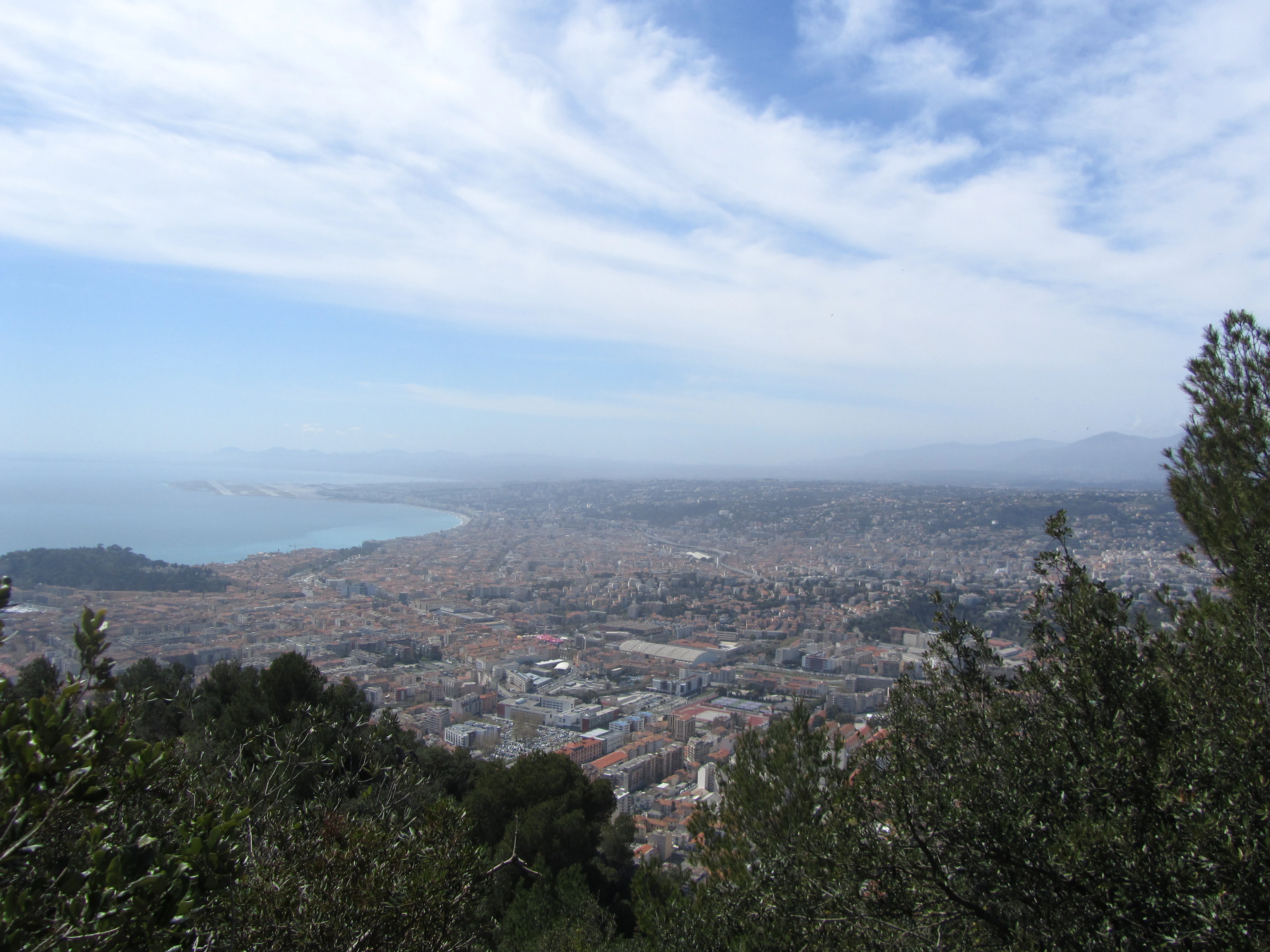
A wide aerial view looking down over the sprawling urban landscape of Nice, France, framed by treetops in the foreground with the Mediterranean Sea and horizon in the background.
Panoramic view of the city of Nice and the Mediterranean coastline seen from the elevated slopes of Parc naturel départemental du Vinaigrier.

Parc naturel départemental du Vinaigrier history and protected-area timeline

Through the mid-twentieth century, the site of Mont Vinaigrier was a working agricultural landscape, with olive terraces and a farm operating on the hill. This traditional use kept the area as productive rural land rather than as natural parkland, but it left the slopes vulnerable to redevelopment once Nice's suburbs expanded eastward.

In 1973, a zone d'aménagement concerté, a coordinated urban development plan, was drawn up for the site. The project envisioned around 800 housing units, a hotel, some thirty villas, a swimming pool, and a restaurant on what is today the park. Local residents, notably members of an association that included scientists from the Nice Observatory, organized in 1975 to oppose the development, and the project was abandoned in November 1976.

In October 1980, the roughly 24-hectare site was bought back from the two property developers by the Conservatoire du littoral together with the City of Nice, ending the threat of urban development and beginning the transition toward protected natural area status. The Alpes-Maritimes department has been responsible for managing the park since 1988, and a formal park regulation was issued in December 2019.

Parc naturel départemental du Vinaigrier landscape and geographic character

The physical setting of the park is dominated by the limestone geology of Mont Vinaigrier. The hill rises to a small calcareous plateau at around 370 meters of altitude, with sides that vary between gentle inclines and steep slopes. The result is a compact three-dimensional terrain rather than a flat extension of the coast: visitors encounter layered contours, exposed rock, and sudden transitions from open plateau to wooded ravine.

Where the slopes flatten, the soil is thicker, and the historical imprint of human land use is clear. The hill retains an extensive network of old dry-stone terrace walls, the restanques typical of Niçois agriculture, which today function as informal landscape architecture rather than as productive fields. These terraces compartmentalize the hillside into small compartments of woodland, with broken stone walls providing shelter, perches, and microhabitats for smaller species.

The contrast between plateau and slope is also central to the park's visual identity. The upper plateau reads as a more open, sunlit Mediterranean scene of pines and holm oaks against pale limestone rock, while the slopes feel denser and lusher, especially in spring when the flowering ash stands are in bloom. From the upper entry to the park, the view opens out over the Bay of Nice, anchoring the local Mediterranean coastal landscape visually within the site.

Parc naturel départemental du Vinaigrier ecosystems, habitats, and plant life

The Parc du Vinaigrier lies at the interface between Mediterranean lowland ecosystems and the limestone hills that rise above Nice. The plateau vegetation is typical of dry calcareous Mediterranean woodland: a relatively open canopy of Aleppo pines scattered over holm oaks and an understory adapted to thin, stony soils and intense summer drought. This upper zone represents the harsher, sun-exposed face of the hill.

On the slopes, conditions are slightly more favorable to moisture-loving species, and the dominant tree becomes Fraxinus ornus, the flowering ash. This species is relatively uncommon in the Alpes-Maritimes coastal fringe, which makes its presence on Mont Vinaigrier notable from a botanical perspective. In May, the flowering ash blooms across the hillsides, transforming slopes that otherwise remain warm and dry for much of the year into a softer, more colorful environment.

Ecologically, the park functions as a critical refuge within a heavily urbanized stretch of coast. Its combination of open plateau, terraced slopes, and wooded ravines creates a small but unusually diverse mosaic of habitats within a very limited area. This mosaic, along with its proximity to the sea, supports both resident wildlife and seasonal visitors, and it is one of the key reasons the site retains ecological significance despite its modest size.

Parc naturel départemental du Vinaigrier wildlife and species highlights

Although the park is small and pressed against the urban edge of Nice, it sustains a notably rich community of fauna. Small mammals are common throughout the site, with hedgehogs, red squirrels, red foxes, and European badgers all reported in the area. These species benefit from the mix of dense cover, stone walls, and relatively undisturbed soils provided by the terraces and woodland.

Birdlife is particularly noteworthy. The park documents around 59 bird species, including both sedentary species and migratory visitors. Among the regularly present resident species are great tits, Eurasian sparrowhawks, and Sardinian warblers, characteristic Mediterranean woodland birds. Migrants recorded in or passing through the park include common swifts, European pied flycatchers, and white-fronted redstarts, reflecting the site's role as a seasonal stepping stone between the coast and inland hills.

The combination of a wooded plateau, terrace structure, and proximity to the coast produces a layered habitat where birds can occupy different niches on a single hill. Raptors and insectivores hunt across the open canopy, while smaller passerines find shelter in the understory and along the old stone walls. The site's biodiversity within an urban context is one of the defining features of the park.

Parc naturel départemental du Vinaigrier conservation status and protection priorities

The main conservation value of the Parc du Vinaigrier is that it safeguards a sizeable Mediterranean natural area right at the edge of one of the most densely developed coastlines in France. By preserving the limestone plateau, terraces, and associated woodland, the park maintains a habitat complex that would otherwise almost certainly have been overwritten by the urban development of the eastern Nice littoral.

The protected area is classified in IUCN Category IV, recognizing its role as a habitat and species management area. Ownership rests with the Conservatoire du littoral, a French public agency dedicated to coastal land protection, and the City of Nice, while day-to-day management is handled by the Alpes-Maritimes department. This institutional mix reflects both coastal conservation priorities and the park's role within the departmental network of nature areas.

Conservation significance is reinforced by the site's biodiversity density. The park hosts an unusually high bird count in a compact Mediterranean coastal setting, a presence of flowering ash that is regionally uncommon, and mammal communities that have largely been excluded from the surrounding urban fabric. By retaining these features in a heavily pressured region, the park contributes to landscape connectivity along the Côte d'Azur and serves as a reference site for the management of small Mediterranean protected areas near major cities.

Parc naturel départemental du Vinaigrier cultural meaning and human context

The Parc du Vinaigrier carries a strong local cultural identity because it was saved by a community-driven campaign in the 1970s. When plans emerged to turn Mont Vinaigrier into a large residential and hotel development, an association of local residents combined with scientists from the Nice Observatory to oppose the project. The successful resistance to the development turned the hill into a shared local heritage site rather than a private real-estate venture.

The terraces that cover much of the hillside are a tangible reminder of older Niçois land use. Olive cultivation on restanques shaped the rural identity of the hills behind Nice for centuries, and although the agriculture itself has ended, its stone infrastructure still defines the visual and cultural texture of the park. Walking the park in this sense is also walking through a layered history of coastal Niçois rurality.

Today, the park functions as a shared public space where nearby residents, school groups, walkers, and naturalists intersect. Its proximity to central Nice makes it a reference point in local environmental awareness, evidence that meaningful nature reserves can be maintained in the heart of a Riviera city.

Top sights and standout views in Parc naturel départemental du Vinaigrier

A preserved Mediterranean limestone hill just outside central Nice, with Aleppo pine woodland, holm oak stands, and a regionally rare flowering ash forest that blooms in May. The compact 25-hectare site supports around 59 bird species and a small-mammal community including hedgehogs, foxes, and badgers, within immediate reach of a major coastal city.

The park also stands out for the way it was created: a community-led campaign in the 1970s blocked a major 800-unit development, and the land was later acquired by the Conservatoire du littoral and the City of Nice in 1980, with management passed to the Alpes-Maritimes department in 1988.

Best time to visit Parc naturel départemental du Vinaigrier

Spring is particularly appealing at the Parc du Vinaigrier, especially in May, when the flowering ash trees that dominate the slopes come into bloom against a backdrop of fully leafed Mediterranean woodland. Cooler temperatures and softer light also make this a comfortable period for walking the park's terrace paths and for observing migratory bird activity.

Early autumn offers a quieter experience, with lower visitor numbers and warm but heat-eased conditions; this is a good time to see the Aleppo pine and holm oak landscape at its most typical, alongside retreating migratory species. Summer visits are pleasant but hot, and the exposed limestone plateau offers little shade, so visitors should plan around cooler hours. Winter tends to be the calmest period, when the park's structure of terraces, woodland edges, and rocky open areas is most clearly visible without dense foliage.


Monthly climate preview

Long-term representative point measurements tracking monthly temperature and precipitation variation

Parc naturel départemental du Vinaigrier Climate Normals and Annual Temperature Rhythm

Representative coordinates record annual temperature progression alongside shifting monthly precipitation levels at Parc naturel départemental du Vinaigrier. Examining the full twelve-month dataset clarifies long-term meteorological patterns across the protected landscape.
Annual mean17 °C
11 °C24 °C
Jan11°
Feb11°
Mar12°
Apr14°
May17°
Jun21°
Jul24°
Aug24°
Sep21°
Oct18°
Nov14°
Dec12°
Warmest month
August

24.2 °C

Coolest month
February

10.5 °C

Wettest month
November

3.8 mm/day

Driest month
July

0.5 mm/day

Park location guide

Geography guide, regional context, and park location map for Parc naturel départemental du Vinaigrier

Parc naturel départemental du Vinaigrier park geography, regions, and map view in France

Understand where Parc naturel départemental du Vinaigrier sits in France through a broader geographic reading of the surrounding landscape, nearby location context, and its mapped position within the national park landscape.

How Parc naturel départemental du Vinaigrier fits into France

France is a unitary semi-presidential republic and one of the world's largest economies. It borders Belgium, Luxembourg, Germany, Switzerland, Italy, Monaco, Andorra, and Spain, with a maritime border to the United Kingdom. The country is known for its cultural influence, art, cuisine, and political history spanning centuries.

Wider geography shaping Parc naturel départemental du Vinaigrier in France

France is located in Western Europe. Metropolitan France extends from the Rhine to the Atlantic Ocean and from the Mediterranean Sea to the English Channel and North Sea. The country borders Belgium, Luxembourg, Germany, Switzerland, Italy, Monaco, Andorra, Spain, and has a maritime border with the United Kingdom.

Map view of Parc naturel départemental du Vinaigrier

Use this park location map to pinpoint Parc naturel départemental du Vinaigrier in France, understand its exact geographic position, and read its mapped placement within the surrounding landscape more clearly.

Pigeon | © OpenStreetMap contributors

Location context for Parc naturel départemental du Vinaigrier

Provence-Alpes-Côte d'Azur

Visual reference of Mediterranean woodland, limestone terrain, and coastal hill scenery.

Parc naturel départemental du Vinaigrier Photos and Protected Area Landscapes

Visual documentation captures the limestone plateau, Aleppo pine stands, and terraced slopes defining Parc naturel départemental du Vinaigrier. Photographic records reveal the protected terrain, native habitats, and coastal hill scenery characterizing the urban reserve.

A wide aerial view looking down over the sprawling urban landscape of Nice, France, framed by treetops in the foreground with the Mediterranean Sea and horizon in the background.

Park atlas

Compare surrounding Mediterranean landscapes and coastal hill reserves across the region

Parks Near Parc naturel départemental du Vinaigrier and Regional Protected Areas

Browsing other protected areas near Parc naturel départemental du Vinaigrier reveals connected limestone hill terrain and coastal woodland environments. Expanding the regional park comparison provides broader context on Mediterranean conservation landscapes and departmental nature reserves.
Marine protected areaFrance
About 1.5 km away#1 closest

Southeast

Sanctuaire Pelagos Marine Protected Area: Mediterranean Geography and Seascape

A transboundary conservation zone spanning 87,500 square kilometers.

Sanctuaire Pelagos represents a unique collaborative effort in marine conservation across the Mediterranean. Spanning the waters between France, Italy, and Monaco, this protected maritime area is defined by its deep-sea canyons and nutrient-rich currents that sustain diverse cetacean populations. Its immense scale and international governance make it a focal point for understanding Mediterranean marine biodiversity and environmental policy.

Area
87,500 km²
Established
1999
IUCN
IV
Relief
Lowland
A digital illustration of a valley featuring jagged mountain peaks, a waterfall, a winding river, and pine forests in the foreground.
Marine protected areaMonaco
About 11 km away#2 closest

East

Larvotto and Portier Coastal Reserve: Marine Protected Area and Coastal Habitat Atlas

Mapped marine refuge along the dense Monaco shoreline.

The Larvotto and Portier Coastal Reserve represents a distinct marine protected area in Monaco, featuring significant seagrass meadows and transplanted rocky habitats. This coastal zone acts as an essential refuge for Mediterranean biodiversity, providing a rare example of structured marine conservation embedded within a highly developed urban landscape.

Area
0.23 km²
Watercolor painting of a park landscape with a foreground pond, grassy areas, and rolling hills in the background.
State or regional parkProvence-Alpes-Côte d'Azur
About 17 km away#3 closest

Southwest

Parc de Vaugrenier: Regional Protected Area and Archaeological Landscape in France

Wetland habitats and historic trails in Alpes-Maritimes

Parc de Vaugrenier protects a diverse hundred-hectare expanse between Antibes and Villeneuve-Loubet. Its terrain bridges Mediterranean woodland and lush freshwater meadows, distinguished by a rare collection of exotic trees and remnants of the ancient Via Julia Augusta. This park provides a quiet geographic contrast to the surrounding coastal urbanization of the French Riviera.

Area
1 km²
Established
1995
Visitors
500K annual
Relief
Lowland
A soft watercolor illustration depicting a panoramic view of rolling green hills under a pale, warm sky with distant mountains.
State or regional parkProvence-Alpes-Côte d'Azur
About 18 km away#4 closest

West

Parc naturel départemental du Plan des Noves: Protected Landscapes and Regional Geography

Upland limestone plateau in the French Baous massif

Covering 904 hectares above the town of Vence, this park features a unique combination of Mediterranean woodlands, open pastoral mosaics, and historic agricultural terraces. The terrain serves as a vital ecological corridor, recognized for its birdlife and reptiles, while its elevation offers expansive vistas across the surrounding regional geography from the coast to the high mountain summits.

Area
9.04 km²
Established
1987
Relief
Upland
Scope
Terrestrial
Watercolor illustration of a mountainous landscape featuring a river, rolling hills, and green vegetation
National parkFrance
About 23 km away#5 closest

North

Mercantour National Park: Mapped Alpine Protected Landscape and Regional Geography

Explore France's dramatic Alps, park boundaries, and unique ecotones.

Mercantour National Park stands as a premier protected area within the French Alps, distinguished by its remarkable geographic diversity and ecological significance. This national park encompasses mountainous terrain featuring dramatic peaks, deep glacial valleys, and a unique ecotone where Mediterranean and Alpine ecosystems converge. MoriAtlas facilitates a detailed atlas-style exploration of Mercantour National Park, highlighting its mapped protected boundaries, varied natural landscapes, and its pivotal role in regional geography and conservation efforts.

Area
679 km²
Established
1979
IUCN
II
Visitors
800K annual
State or regional parkAlpes-Maritimes
About 28 km away#6 closest

Northwest

Parc naturel départemental de l'Estéron: Riverside Geography in Alpes-Maritimes

A departmental park focusing on the wild Estéron River corridor

Located in the hinterland of the Côte d'Azur, Parc naturel départemental de l'Estéron provides a protected environment focused on the Estéron river valley. Its geography encompasses sun-exposed Mediterranean hillsides and riparian zones, reflecting the intersection of mountain terrain and historic cross-border heritage in the Alpes-Maritimes department.

Area
0.2 km²
Established
2011
Scope
Terrestrial
Water
Major water bodies
A soft watercolor painting of a coastal landscape with rolling hills, distant mountains, and green vegetation against a light sky.
Marine protected areaProvence-Alpes-Côte d'Azur
About 37 km away#7 closest

Southwest

Parc maritime départemental Estérel-Théoule: Marine Protected Area and Coastal Geography

A vital Mediterranean corridor along the French Riviera coast

This marine protected area preserves a unique underwater mosaic where rocky shallows, sandy patches, and Posidonia seagrass meadows converge. Located offshore from the Estérel massif, the site provides a continuous conservation corridor between inland natural spaces and the Mediterranean Sea, offering insight into the littoral environment of the French Riviera.

Area
3.5 km²
Water
Water-dominated
Season
Seasonal
A watercolor illustration showing a landscape with red rock formations, green vegetation, and a winding blue river.
Nature reserveProvence-Alpes-Côte d'Azur
About 52 km away#8 closest

Northwest

Réserve naturelle régionale des gorges de Daluis: Red Rock Canyon and Geological Atlas

Protected canyon landscape in Provence-Alpes-Côte d'Azur

Defined by its vivid red pelite cliffs, Réserve naturelle régionale des gorges de Daluis functions as a significant protected canyon system. The terrain preserves rare mineralogy and diverse microhabitats, ranging from river-carved walls to upland slopes that support unique regional biodiversity in the Alpes-Maritimes.

Area
10.82 km²
Established
2012
IUCN
IV
Relief
Mountain

Common questions about visiting, size, designation, and location context for Parc naturel départemental du Vinaigrier

Parc naturel départemental du Vinaigrier FAQs for park facts, access, geography, and protected area context

Find quick answers about Parc naturel départemental du Vinaigrier, including protected-area facts, park geography, trail and visitor context, and how the park fits into its surrounding country and regional landscape.
MoriAtlas Explorer

Continue Your Protected Areas Search Across the Global Atlas

Deepen your exploration by continuing the structured search for national parks and protected areas worldwide. Utilize the comprehensive filtering capabilities to compare different conservation landscapes and refine your understanding of global park geography. Discover more about the distribution and characteristics of protected natural areas.

Global natural geography