Mori Atlas logo
Protected landscapePark Krajobrazowy Wysoczyzny Elbląskiej

Tracing the morainic plateau boundaries, beech-dominated forests, and varied terrain of a distinct upland region.

Park Krajobrazowy Wysoczyzny Elbląskiej: A Geographic Overview of Northern Polish Protected Landscapes

Park Krajobrazowy Wysoczyzny Elbląskiej represents a unique protected landscape in the Warmian-Masurian Voivodeship, characterized by its surprising mountain-like relief and dense beech forests. The geography consists of a morainic plateau cut by numerous stream-carved valleys that transition toward the Vistula Lagoon. This area serves as a vital ecological corridor, safeguarding rare flora and providing critical habitat for birds such as white-tailed eagles and cranes.

beech forestmoraine uplandprotected landscapenature reservesVistula Lagoon regionnorthern Poland

Park Krajobrazowy Wysoczyzny Elbląskiej

Protected landscape

Park overview

Structured park overview, official facts, and landscape profile for Elbląg Upland Landscape Park

Elbląg Upland Landscape Park park facts, protected area profile, and essential visitor context

Review the core facts for Elbląg Upland Landscape Park, including designation, size, terrain, visitor scale, habitats, and operating context in one park-focused overview.

About Elbląg Upland Landscape Park

Elbląg Upland Landscape Park sits in the northernmost reaches of Poland, just inland from the Vistula Lagoon. Its location at the far end of the country might suggest an ordinary lowland landscape, but the protected area is unusually hilly, and its forests contain species more typical of mountainous regions further south. This unusual combination of northern geography with upland-like ecology defines the character of the park and the interest it holds for both visitors and ecologists.

The park covers the most scenic and ecologically valuable portions of the Wysoczyzna Elbląska, a moraine plateau that rises noticeably above the surrounding lowlands. Although the highest summit, Góra Srebrna, reaches only 198.5 meters, the relative relief, stream valleys, and forest cover give it an appearance far more dramatic than its absolute elevation suggests. The park's terrain is interspersed with numerous small streams and brooks flowing down toward the lagoon, creating a varied mosaic of slopes, ravines, and moist valley bottoms.

Beech forest is the most characteristic vegetation type of the park, and it is the presence of these mature, shady woodlands combined with local climate conditions that allows mountain-indicator plants to persist here. The park's forests are not uniform: alongside the dominant beech stands are mixed deciduous communities, while the lower and wetter zones support different habitats, including riparian vegetation along the streams. Five nature reserves protect the most valuable pockets, including the famous Kadyński Las, the beech forests of the upland themselves (Buki Wysoczyzny Elbląskiej), the Stradanka Valley (Dolina Stradanki), the Nowinka reserve, and small parts of the Elbląg Bay (Zatoka Elbląska).

Geographic diversity is matched by cultural diversity. The park includes or borders on several communes that carry their own historical identity, and historic sites such as Frombork, the cathedral city on the lagoon that was home to the astronomer Nicolaus Copernicus, lie within its wider context. The baroque palace at Kadyny is one of the park's signature attractions, blending landscape beauty with regional architectural heritage.

Quick facts and research context for Elbląg Upland Landscape Park

Elbląg Upland Landscape Park was established on 26 April 1985 by Resolution No. VI/51/85 of the Provincial National Council in Elbląg, making it one of the older landscape parks in the Warmian-Masurian region. It lies in the Warmian-Masurian Voivodeship and is administered across the communes of Elbląg, rural Elbląg, Tolkmicko, Milejewo, and Frombork.

The park covers roughly 134 square kilometers of protected land and is surrounded by a buffer zone of about 77 square kilometers. It sits on the Elbląg Upland (Wysoczyzna Elbląska) and partly on the Staropruskie Coast (Wybrzeże Staropruskie), reaching the edge of the Vistula Lagoon. Five nature reserves fall within or touch its boundaries, including the famous Bażyński Oak, and the highest point of the park is Góra Srebrna at 198.5 meters above sea level.

Protection and recognition

Documented terrestrial protection scope, designation framework, and recognition data

Park Krajobrazowy Wysoczyzny Elbląskiej Protection Status and Recognition

Park Krajobrazowy Wysoczyzny Elbląskiej maintains a documented terrestrial protection scope within the regional protected area network. Structured conservation records compile official designation details and international recognition sources where available for this landscape.

Protection details

Protection scope
Terrestrial
Transboundary protection
No
Buffer area
229.48 km²
Park context

Deeper park guide and search-rich context for Elbląg Upland Landscape Park

Elbląg Upland Landscape Park history, landscape, wildlife, and travel context

Explore Elbląg Upland Landscape Park through its history, landscape character, ecosystems, wildlife, conservation priorities, cultural context, and seasonal travel timing in a structured park guide built for atlas discovery and search intent.

Why Elbląg Upland Landscape Park stands out

The park is best known for its beech forests and its surprisingly mountain-like character in one of the flattest parts of Poland. Plant species normally associated with the Sudetes or Carpathians, such as ostrich fern, mountain pteridophyte (Żebrowiec górski), and the martagon lily, grow here because of the local microclimate created by the upland's elevation and terrain. It is also recognized for its scenic viewpoints, stream-cut valleys, and the proximity of cultural highlights such as the baroque palace complex at Kadyny, which sits within the park's area. Birdlife, particularly the presence of white-tailed eagles, common cranes, and lesser spotted eagles, adds to the park's ecological reputation, while the Bażyński Oak in the Kadyński Las reserve stands as one of the most celebrated old trees in the region.
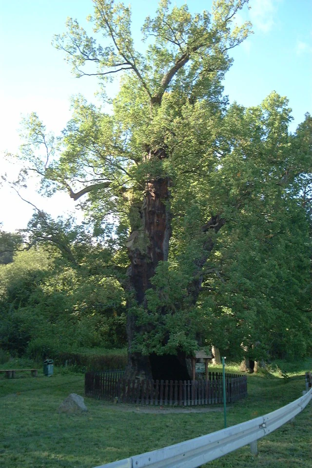
A large, ancient oak tree with a thick, gnarled trunk enclosed by a low wooden fence in a park setting.
The historic Bazynski Oak, a protected ancient tree in the Elblag Upland Landscape Park.

Elbląg Upland Landscape Park history and protected-area timeline

The Elbląg Upland Landscape Park was created on 26 April 1985 through Resolution No. VI/51/85 of the Provincial National Council (Wojewódzka Rada Narodowa) in Elbląg. Its establishment came during a period when Polish regional authorities were actively expanding the network of protected landscape areas to safeguard the country's most distinctive regional scenery, and the Elbląg Upland, with its unusual combination of beech forests and upland-like terrain, was recognized as a worthy candidate.

The park was originally designated under the name Park Krajobrazowy Wzniesienie Elbląskie, reflecting the elevated nature of the terrain. Over time, the current name, emphasizing the geographic term Wysoczyzna Elbląska, became standard. The change in name also reflected evolving terminology in Polish physical geography.

Within the park's boundaries, several nature reserves were separately designated to protect the most ecologically sensitive features. These reserves, including Kadyński Las and Buki Wysoczyzny Elbląskiej, had protection histories of their own, and their inclusion within the landscape park brought them under a unified regional conservation framework. The cultural heritage of the region, including the palace at Kadyny and the broader Frombork area, has historically been intertwined with the natural landscape, and the park's protection status has helped reinforce the value of that combined heritage.

Elbląg Upland Landscape Park landscape and geographic character

The landscape of the Elbląg Upland Landscape Park is dominated by a morainic plateau that rises between the Vistula Lagoon and the lower-lying plains further inland. Although absolute elevations are modest, the terrain is distinctly hilly, with the highest point, Góra Srebrna, reaching 198.5 meters above sea level. The varied relief of the plateau produces a sequence of slopes, ridges, and valleys that give the park much of its visual character.

A dense network of small streams and brooks flows down from the upland, often cutting shallow valleys into the surrounding terrain. These watercourses, alongside moist valley bottoms and small wetland fringes, create a mosaic of micro-landscapes that contrast with the drier forest-covered slopes above. The proximity of the park to the Staropruskie Coast and the Vistula Lagoon adds an additional element, allowing transitions from rolling inland hills to coastal scenery within a relatively short distance.

The forest cover is the most visually dominant feature of the park from any elevated vantage point. Beech and mixed deciduous forests extend over much of the upland, interrupted only occasionally by clearings, stream valleys, and the historic parkland around Kadyny. The combination of forest, undulating terrain, and small watercourses produces a landscape that feels far more elevated than its actual altitude, and that visual impression is one of the park's defining traits.

Elbląg Upland Landscape Park ecosystems, habitats, and plant life

The park's nature is defined first and foremost by its beech forests, which cover much of the upland and give it a distinctly Central European forest character. These beech communities dominate the upland slopes and form the basis of the park's identity as a forest landscape park. Mixed deciduous stands, with oak, hornbeam, and other broadleaf species, supplement the beech, especially in transitional areas, while wetter zones support richer riparian vegetation along the streams.

One of the most remarkable features of the park is the presence of plant species normally associated with mountainous regions of Poland. The ostrich fern (Matteuccia struthiopteris), mountain wall-rue relative Żebrowiec górski, and the striking martagon lily (Lilium martagon) all grow here, surviving in the cool microclimate created by elevation, slope, and dense forest cover. This unusual botanical profile in such a northern location has historically drawn the attention of botanists and gives the park elevated ecological significance.

Ecological diversity extends beyond the forests themselves. Stream valleys support a distinct flora and fauna, while the proximity of the Vistula Lagoon introduces coastal and wetland influences at the edges of the park. Five nature reserves, including Kadyński Las, Buki Wysoczyzny Elbląskiej, Dolina Stradanki, Nowinka, and partial sections of Zatoka Elbląska, protect the park's most ecologically important sites, ensuring that the rare plant communities and old-growth forest stands remain intact.

Elbląg Upland Landscape Park wildlife and species highlights

Wildlife in the Elbląg Upland Landscape Park reflects the combination of mature deciduous forest, stream valleys, and proximity to the Vistula Lagoon. Large mammals such as red deer are present in the forested upland, while smaller and more unusual species, including the forest dormouse (popielica) and the raccoon dog (jenot), add to the park's mammalian diversity. These species are typical of well-preserved deciduous woodland and indicate the ecological health of the park's habitats.

Birdlife is one of the park's strongest natural attractions. White-tailed eagles (bielik) are present in the area, as are common cranes (żuraw), which favor the wetland edges and quieter forested areas. The lesser spotted eagle (orlik krzykliwy) is especially notable as a relatively rare species of conservation concern, while the honey buzzard (trzmielojad) and other common forest raptors round out the raptor community. Mixed deciduous forests and stream corridors provide breeding habitat for a wide range of smaller songbirds and woodland species.

The five nature reserves within the park, especially the old-growth forests of Kadyński Las, host particularly rich invertebrate and saproxylic communities associated with ancient trees. The famous Bażyński Oak, a celebrated old oak within Kadyński Las, is itself a habitat for specialized fauna and fungi. The combined presence of large mammals, rare raptors, and old-forest specialists gives the park a wildlife profile that stands out among protected areas in northern Poland.

Elbląg Upland Landscape Park conservation status and protection priorities

From a conservation standpoint, the park is important primarily because it protects one of the largest and most ecologically significant beech forest complexes in northern Poland. The mature beech stands on the Elbląg Upland host a suite of species, including mountain-indicator plants, that are otherwise rare in this part of the country. Protecting these forests ensures the long-term survival of plant communities that depend on stable, undisturbed woodland conditions.

The park's nature reserve network strengthens its conservation role. The Kadyński Las reserve safeguards old-growth forest and the celebrated Bażyński Oak, a tree of major natural and cultural significance. Buki Wysoczyzny Elbląskiej directly protects representative beech forest communities, while Dolina Stradanki preserves a stream valley with associated habitats. Together, the reserves ensure that the park's key ecological features are subject to a higher level of protection than the surrounding landscape zone.

The buffer zone (otulina) surrounding the park, covering roughly 77 square kilometers, plays an important role by reducing external pressures on the protected core. The combination of reserves, buffer zone, and the broader landscape park designation creates a layered conservation framework that supports large mammals, breeding raptors, and old-forest specialists. The park's conservation value is further enhanced by its role as a refuge for species such as the lesser spotted eagle and the forest dormouse, both of which benefit from large, connected tracts of mature forest.

Elbląg Upland Landscape Park cultural meaning and human context

The park lies within a region of Poland with a rich and layered cultural history. The city of Elbląg, with its medieval Hanseatic heritage, anchors the area, while Frombork, on the edge of the Vistula Lagoon, is famed as the home of the astronomer Nicolaus Copernicus. The combination of forest landscape and proximity to such historically significant places gives the park strong cultural context.

Within the park itself, the baroque palace at Kadyny is one of the most distinctive cultural sites. Originally associated with the estate of the Bażyński family and later rebuilt in a baroque style during the early twentieth century, the palace complex is set within parkland that complements the surrounding protected forests. The nearby Bażyński Oak, one of the oldest and most impressive trees in Poland, links natural and cultural heritage in a single landmark.

The surrounding communes of Tolkmicko, Milejewo, and rural Elbląg each carry their own local traditions and identity, shaped by the mixed German, Prussian, and Polish history of the region. This layered human history, combined with the well-preserved natural landscape, makes the park a place where nature conservation and regional heritage intersect meaningfully.

Top sights and standout views in Elbląg Upland Landscape Park

The park's standout features include its mountain-like beech forests at the far northern edge of Poland, the rare presence of mountain-indicator plant species in a lowland region, and the dramatic Góra Srebrna summit, which offers sweeping views over the upland and toward the Vistula Lagoon. These natural landmarks combine with the cultural anchor of the baroque palace at Kadyny to give the park a distinctive identity.

Birdlife is another highlight, with white-tailed eagles, common cranes, and the lesser spotted eagle among the species that bring the park's skies and forests to life. Ancient trees such as the Bażyński Oak, protected within the Kadyński Las reserve, add both ecological and cultural weight to a visit. The five nature reserves scattered across the park provide concentrated opportunities for visitors to engage with the most ecologically valuable sites, while the buffer zone preserves the wider landscape that supports them.

Best time to visit Elbląg Upland Landscape Park

The park is most rewarding in late spring and early summer, when the beech canopy is fully leafed out, the streams are flowing, and forest birds are at their most active. White-tailed eagles and common cranes are more easily observed during these months, while the martagon lily and other forest-floor plants typically bloom in early to mid-summer under the canopy.

Autumn also brings its own appeal, with the beech forests turning color and the broader upland taking on warm tones that emphasize the park's rolling relief. Cooler, quieter conditions in this season can be good for observing deer and other large mammals as they move more visibly through the forests. Winter, with snow on the upland slopes, can dramatically highlight the park's mountain-like character, though colder conditions limit some wildlife viewing opportunities. Each season offers a different reading of the park's landscape and ecology.

Monthly climate preview

Long-term representative temperature and precipitation patterns across twelve months

Park Krajobrazowy Wysoczyzny Elbląskiej Climate Normals and Annual Weather by Month

Representative coordinate measurements record distinct annual temperature ranges and steady monthly precipitation totals across Park Krajobrazowy Wysoczyzny Elbląskiej. Examining the complete twelve-month climatology profile reveals deeper long-term averages and regional weather trends.
Annual mean9 °C
0 °C19 °C
Jan
Feb
Mar
Apr
May11°
Jun15°
Jul18°
Aug19°
Sep15°
Oct10°
Nov
Dec
Warmest month
August

18.8 °C

Coolest month
January

0.4 °C

Wettest month
November

2.4 mm/day

Driest month
April

1.3 mm/day

Park location guide

Geography guide, regional context, and park location map for Elbląg Upland Landscape Park

Elbląg Upland Landscape Park park geography, regions, and map view in Poland

Understand where Elbląg Upland Landscape Park sits in Poland through a broader geographic reading of the surrounding landscape, nearby location context, and its mapped position within the national park landscape.

How Elbląg Upland Landscape Park fits into Poland

Poland, officially the Republic of Poland, is a Central European country spanning from the Baltic Sea in the north to the Carpathian Mountains in the south. It borders Germany, Czech Republic, Slovakia, Ukraine, Belarus, Lithuania, and Kaliningrad Oblast. The country has a temperate climate, diverse landscapes, and is known for its rich history, cultural heritage, and strong economic position within the EU.

Wider geography shaping Elbląg Upland Landscape Park in Poland

Poland occupies 312,696 km2 in Central Europe, extending from the Baltic Sea coast in the north to the Sudetes and Carpathian Mountains in the south. It borders Germany to the west, Czech Republic and Slovakia to the south, Ukraine and Belarus to the east, and Lithuania and Kaliningrad Oblast to the northeast. The landscape includes lowland plains, uplands, and mountain ranges.

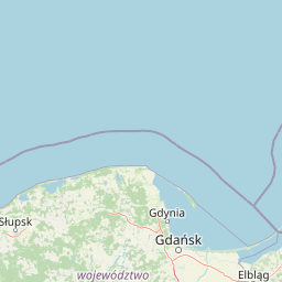
Map view of Elbląg Upland Landscape Park

Use this park location map to pinpoint Elbląg Upland Landscape Park in Poland, understand its exact geographic position, and read its mapped placement within the surrounding landscape more clearly.

Pigeon | © OpenStreetMap contributors

Location context for Elbląg Upland Landscape Park

Warmian-Masurian Voivodeship
Recorded earthquake history

Explore Recorded Earthquake Data for Park Krajobrazowy Wysoczyzny Elbląskiej

Consult the historical earthquake catalogue associated with Park Krajobrazowy Wysoczyzny Elbląskiej. This MoriAtlas data view offers transparent access to seismic records near the park, allowing for detailed investigation of local activity through structured, geography-focused event metrics.

Earthquake History for Park Krajobrazowy Wysoczyzny Elbląskiej

Catalogued events

1 event

Strongest magnitude

Magnitude 4

Most recent event

Feb 23, 1995

This history includes earthquakes recorded inside the park or within 50 km of its borders

Visual reference of hilly terrain, beech forests, and upland protected habitats

Park Krajobrazowy Wysoczyzny Elbląskiej Photos and Protected Landscape Scenery

Visual records capture the distinctive moraine plateau, dense stream valleys, and mountain-like beech forests defining Park Krajobrazowy Wysoczyzny Elbląskiej. Photographic documentation reveals the upland topography and protected habitats rising above the Vistula Lagoon coast.

A large, ancient oak tree with a thick, gnarled trunk enclosed by a low wooden fence in a park setting.

Park atlas

Compare adjacent forest reserves, moraine uplands, and northern regional landscapes

Parks near Park Krajobrazowy Wysoczyzny Elbląskiej and surrounding protected areas

Browsing parks near Park Krajobrazowy Wysoczyzny Elbląskiej reveals connected protected landscapes and varied northern terrain. Comparing surrounding regional geography provides a broader perspective on morainic plateaus and coastal ecosystems.
A soft watercolor illustration depicting a river valley with green vegetation, rolling hills, and marshy banks, rendered in light washes.
Nature reserveWarmian-Masurian Voivodeship
Mapped location lies within the park boundary#1 closest

Northeast

Rezerwat przyrody Dolina Stradanki: Protected Forest and River Valley Geography

Nature reserve within the Warmian-Masurian Voivodeship

Rezerwat przyrody Dolina Stradanki is a critical protected area in northern Poland, known for its intricate system of side valleys and mature beech forest. This reserve integrates hydrological and biological values, functioning as a key ecological unit within the Elbląg Upland Landscape Park. Explore the map of this glacial valley, which provides a high-quality habitat for diverse avifauna and protected flora.

Area
1.211 km²
Established
2006
Relief
Upland
Scope
Terrestrial
Protected landscapePoland
About 7.2 km away#2 closest

Northwest

Zalew Wiślany i Mierzeja Wiślana Protected Landscape and Vistula Coastal Geography

A coastal mosaic of lagoon waters, sand dunes, and bog forests

Understand the physical landscape of Zalew Wiślany i Mierzeja Wiślana, featuring an aquatic environment where three quarters of the territory consists of brackish water. Trace the geography of the Vistula Sandspit as it transitions through dune successions, pine-birch woodlands, and sensitive estuarine meadows along the Polish coast.

Area
408.623 km²
Relief
Lowland
Climate
Temperate
Scope
Mixed
A soft watercolor painting of a marshy coastal landscape with tall grasses, calm water, and distant dunes under a bright, clear sky.
Nature reservePomeranian Voivodeship
About 30 km away#3 closest

West

Rezerwat przyrody Mewia Łacha: Protected Coastal Geography and Vistula Estuary Map

Dynamic Baltic sandbars and migratory bird habitat in Pomerania

Rezerwat przyrody Mewia Łacha occupies a vital coastal strip where river discharge meets the Gulf of Gdańsk. This nature reserve serves as an essential site for migratory waterfowl and nesting terns, defined by its shifting sandbars, dune slacks, and brackish pools. It stands as a key example of the varied estuarine geography found within the Pomeranian Voivodeship.

Area
1.505 km²
Established
1991
Relief
Lowland
Climate
Temperate
A wide panoramic watercolor illustration showing a pastoral landscape with green rolling hills, a winding river, scattered trees, and a soft sky with pink and yellow hues.
Protected areaPomeranian Voivodeship
About 49 km away#4 closest

West

Twierdza Wisłoujście Protected Area: Coastal Geography and Historical Mapping in Gdańsk

A historic Baltic fortification and vital ecological site in Pomeranian Voivodeship.

Explore the layered masonry and water-influenced landscape of Twierdza Wisłoujście, a coastal fortress established on the delta of the Vistula River. This site bridges the history of maritime defense and modern ecological conservation as a designated Natura 2000 area. Examine how shifting river channels and centuries of construction define the current defensive perimeters and moated surroundings within the Pomeranian Voivodeship.

Established
1482
Relief
Lowland
Climate
Temperate
Access
Easy access
Nature reserveGdańsk
About 51 km away#5 closest

West

Zbiornik Wody Stara Orunia: A Protected Industrial Heritage Site and Nature Reserve in Gdańsk

Historic brick architecture meeting urban bat conservation zones

Built in 1869, this historic underground reservoir in the Orunia district of Gdańsk combines rare Prussian engineering with a vital role as a Natura 2000 protected habitat. The site serves as a key component of the regional water trail, offering a look into the complex relationship between industrial infrastructure, urban landscape development, and the protection of essential wildlife hibernation cycles.

Area
0.001 km²
Established
1869
Relief
Upland
Climate
Temperate
Nature reservePomeranian Voivodeship
About 56 km away#6 closest

West

Dolina Kłodawy Nature Reserve: Geography and Botanical Protected Areas in Pomeranian Voivodeship

Glacial river gorge landscapes in Northern Poland

This protected area centers on a 1.6 kilometer section of the Kłodawa stream, showcasing complex forest ecosystems including ash-alder woodlands and oak-hornbeam slopes. The site remains a vital reference for regional botanical geography, highlighting how glacial moraine hills create unique habitats for rare plants within the Pomeranian Voivodeship landscape.

Area
0.104 km²
Established
1999
Relief
Lowland
Climate
Temperate
Nature reservePomeranian Voivodeship
About 57 km away#7 closest

West

Dolina Strzyży Nature Reserve Protected Forest and Stream Valley Geography

Natural riparian forest in Pomeranian Voivodeship

Explore the geographic profile of Dolina Strzyży Nature Reserve, a protected valley woodland in the Pomeranian Voivodeship of Poland. This reserve maintains dense oak-hornbeam habitats and stream-side ecosystems, functioning as a vital green connection between urban Gdańsk and the expansive Trójmiejski Park Krajobrazowy, preserving historic forest remnants.

Area
0.385 km²
Established
2007
Relief
Upland
Climate
Temperate
Protected landscapePomeranian Voivodeship
About 60 km away#8 closest

West

Trójmiejski Park Krajobrazowy: Protected Landscape and Glacial Geography in Pomerania

Exploring the forested moraine upland near the Baltic coast

Covering nearly 20,000 hectares, Trójmiejski Park Krajobrazowy forms an essential green belt along the Kashubian moraine. Its terrain is defined by dramatic erosion, including 80-meter deep ravines and extensive pine-beech forests that host rare relic plant species and protected peatland habitats.

Area
199.3 km²
Established
1979
Relief
Upland
Climate
Temperate

Common questions about visiting, size, designation, and location context for Elbląg Upland Landscape Park

Elbląg Upland Landscape Park FAQs for park facts, access, geography, and protected area context

Find quick answers about Elbląg Upland Landscape Park, including protected-area facts, park geography, trail and visitor context, and how the park fits into its surrounding country and regional landscape.
MoriAtlas Explorer

Continue Your Protected Areas Search Across the Global Atlas

Deepen your exploration by continuing the structured search for national parks and protected areas worldwide. Utilize the comprehensive filtering capabilities to compare different conservation landscapes and refine your understanding of global park geography. Discover more about the distribution and characteristics of protected natural areas.

Global natural geography