
Mori Atlas logo
Protected landscapeParque rural de Betancuria

Analyzing the dramatic massif, deep barrancos, and ancient island terrain of Canarias

Parque rural de Betancuria: Protected Landscape and Geological Heritage in Fuerteventura

Parque rural de Betancuria spans a central portion of Fuerteventura, representing a core protected landscape within the Canarias region. This area is characterized by the Betancuria Massif, where ancient oceanic sediments, marine fossils, and layered volcanic foundations create a complex topographical display. Beyond its geological significance, the park serves as a vital habitat for endemic flora and diverse bird populations, while preserving a rich ethnographic heritage of traditional rural land use.

rural parkprotected landscapeFuerteventuraCanary Islandsvolcanic geologyBasal Complex
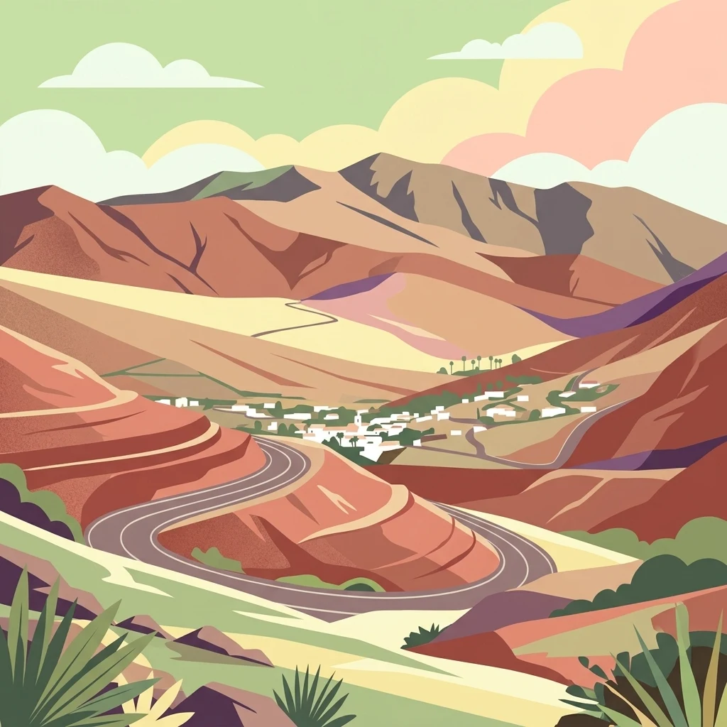
A flat-style vector illustration depicting a mountainous volcanic landscape with a winding road leading to a small village in a valley.

Parque rural de Betancuria

Protected landscape

Park overview

Structured park overview, official facts, and landscape profile for Betancuria Rural Park

Betancuria Rural Park park facts, protected area profile, and essential visitor context

Review the core facts for Betancuria Rural Park, including designation, size, terrain, visitor scale, habitats, and operating context in one park-focused overview.

About Betancuria Rural Park

Betancuria Rural Park represents one of the cornerstone protected landscapes of Fuerteventura, the oldest and most arid of the main Canary Islands. Declared a natural park in 1987 and later reclassified as a rural park in 1994, the protected area occupies an extensive central-western portion of the island, encompassing most of the historic municipality of Betancuria and reaching into the municipalities of Puerto del Rosario, Antigua, Pájara, and Tuineje. The reinterpretation of its designation reflected a deliberate focus on protecting a living cultural landscape as much as a strictly natural one.

Geologically, the park is defined by the Betancuria Massif, an outstanding exposure of the Insular Basal Complex. Here, oceanic sediments and the remains of vanished marine organisms have been thrust upward and preserved within one of the most scientifically valuable geological windows in the archipelago. These ancient materials outcrop alongside younger subaerial volcanic series, producing a landscape characterized by unusual color variation, alternating smooth ridges and deeply incised barrancos, and prominent mountainous spurs that rise sharply above the surrounding island terrain. Notable elevations within the park include Morro Velosa, Morro de la Cruz, Gran Montaña, and Morro Jana.

Ecologically, the park straddles a remarkable transition from arid lowland environments to rugged upland terrain. Rocky cliffs and isolated peaks shelter rupicolous plant communities that include threatened and protected Fuerteventuran endemics. Lower slopes support sparse herbaceous tapestries, aulaga and cardón shrublands, and scattered salt-tolerant tabaibas. The bottoms of the barrancos host denser vegetation, including tarajales, Canary Island date palms, reeds, and juncos. The coastal and wetland edges, particularly around Las Peñitas reservoir and Los Molinos, are particularly important for native and migratory birdlife.

Culturally, Betancuria Rural Park preserves a remarkably intact ethnographic landscape. Gavias, nateros, traditional irrigation channels, waterwheels, lime kilns, corrals, gambuelas, and historic farm buildings dot the protected area, providing a tangible record of generations of human adaptation to the island's difficult climatic conditions. The result is a landscape where natural values and traditional uses coexist, and where geological, ecological, and cultural heritage are protected together under a single management framework administered by the Government of the Canary Islands.

Quick facts and research context for Betancuria Rural Park

Betancuria Rural Park is a protected landscape on Fuerteventura, the easternmost of the two main Canary Islands in Spain's Canary Islands archipelago. It was first declared a natural park by the 1987 Law on the Declaration of Natural Spaces of the Canary Islands and later reclassified by the 1994 Law on Natural Spaces of the Canary Islands, becoming one of the first rural parks in the region.

The protected area spans roughly 16,544 hectares, covering most of the municipality of Betancuria and reaching into four other municipalities on the island. It is administered by the Government of the Canary Islands and also holds Special Protection Area status for birds within the European Natura 2000 network. Within its boundaries sits the Ajuy Natural Monument, a coastal site of high geological interest.

Protection and recognition

Documented terrestrial protection scope and historical designation data

Parque rural de Betancuria Protection Status and Designation History

Terrestrial protection status for Parque rural de Betancuria establishes a formal conservation baseline initiated in the year 1994. Documented designation metrics compile official management scope and historical records for professional geographic research.

Protection details

Protection scope
Terrestrial
Designated year
1994
Transboundary protection
No
Park context

Deeper park guide and search-rich context for Betancuria Rural Park

Betancuria Rural Park history, landscape, wildlife, and travel context

Explore Betancuria Rural Park through its history, landscape character, ecosystems, wildlife, conservation priorities, cultural context, and seasonal travel timing in a structured park guide built for atlas discovery and search intent.

Why Betancuria Rural Park stands out

Betancuria Rural Park is best known for the Betancuria Massif, a spectacular inland uplift that exposes ancient oceanic sediments and marine fossils belonging to the island's Basal Complex. These rocks, together with overlying volcanic formations, create an unusually layered geological landscape that is rare even within the Canary Islands. The park is equally recognized for its combination of dramatic barrancos and notable peaks, including Morro Velosa, Morro de la Cruz, Gran Montaña, and Morro Jana, which rise above smoothly contoured ridges and U-shaped valleys. Its mosaic of habitats supports important Macaronesian endemics such as the sweet tabaiba, the jorjao, and the cuernúa, alongside canaries, blue tits, and the distinctive Fuerteventura Egyptian vulture. The protected area is also celebrated for preserving a continuous weave of traditional rural elements, including gavias, nateros, irrigation channels, waterwheels, lime kilns, corrals, and old farmsteads, that document centuries of cultural transformation of this arid island landscape.
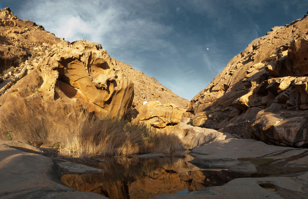
A desert landscape featuring large, weathered sandstone rock formations surrounding a small, reflective pool of water with tall, dry grasses growing near the edge under a cloudy sky.
The rocky gorge and natural pools at Las Penitas in Parque rural de Betancuria.

Betancuria Rural Park history and protected-area timeline

The protection of this territory began with the 1987 Law on the Declaration of Natural Spaces of the Canary Islands, which originally established Betancuria as a natural park. Just seven years later, the 1994 Law on Natural Spaces of the Canary Islands reclassified the area as a rural park, a designation that explicitly acknowledged the importance of maintaining traditional agricultural and rural uses alongside natural values. The Ajuy Natural Monument, a coastal geological site of exceptional interest, was included within the boundary of the new rural park.

In parallel with its national classification, the territory was recognized internationally when it was incorporated into the Natura 2000 network as a Special Protection Area for Birds under the European Birds Directive. This status underscored the importance of the park for both resident species such as the Fuerteventura Egyptian vulture and migratory waterbirds using wetlands within the protected area.

Further legal consolidation came through the 2000 Legislative Decree on Natural Spaces, which preserved the 1994 reclassification. In 2009, the park's use and management plan received final approval, formalizing the regulatory framework that governs permitted, prohibited, and authorizable activities within the rural park and shaping the contemporary manner in which this protected landscape of Fuerteventura is conserved.

Betancuria Rural Park landscape and geographic character

Betancuria Rural Park encompasses a landscape shaped almost entirely by the interplay between deep geological history and long-term erosion. The most prominent feature is the Betancuria Massif, which exposes ancient marine sediments and fossils of vanished organisms as part of the island's Basal Complex, alongside later subaerial volcanic formations. This combination produces unusual chromatic diversity, with layers of contrasting rock tones visible across the slopes.

The terrain alternates between softly rounded ridges and deeply cut barrancos in classic U-shape, framed by substantial mountain spurs within the context of an otherwise relatively low island. Among the most notable elevations are Morro Velosa, Morro de la Cruz, Gran Montaña, and Morro Jana. Their slopes and cliffs create a varied mosaic of microhabitats, from sun-exposed rocks and crevices to sheltered ravine bottoms.

In addition to the inland massif, the park extends to coastal territory that includes the Ajuy Natural Monument. Here, the same ancient geological story continues at the shoreline, where cliffs and platforms expose fossil-rich marine sediments and where the broader pastoral and agricultural landscapes of inland Fuerteventura meet the Atlantic.
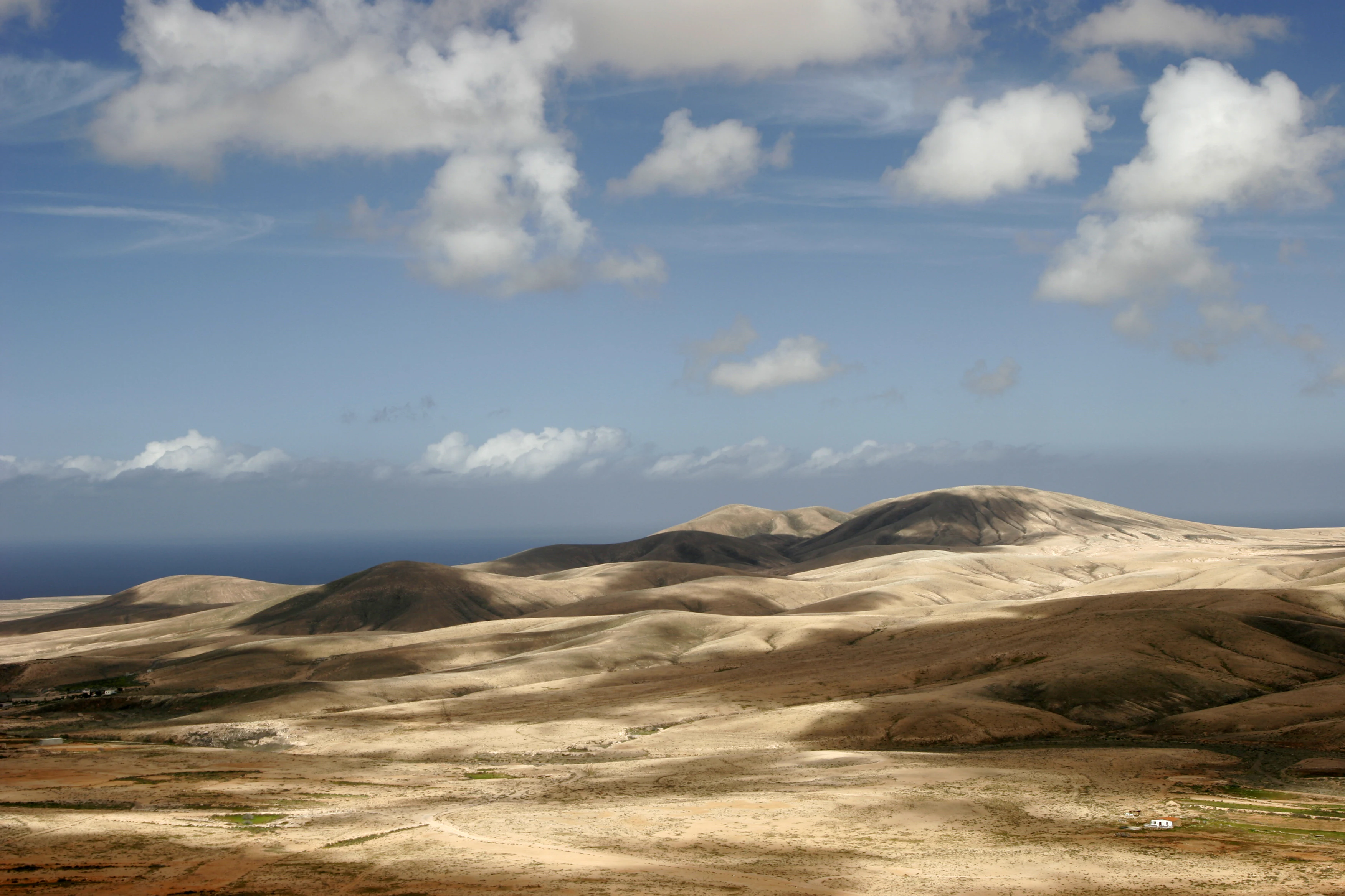
A wide, eye-level photograph of a dry, rolling landscape with brownish hills under a blue sky with scattered white clouds, showing the sea in the distant background.
A wide view of the arid, undulating landscape within Parque Rural de Betancuria on the island of Fuerteventura.

Betancuria Rural Park ecosystems, habitats, and plant life

The vegetation of Betancuria Rural Park reflects the typical ecological gradient of arid Fuerteventura, moving from sparse coastal and lowland formations to richer communities in the damper, sheltered environments of the barrancos. The rocky outcrops and mountain spurs are particularly important for plant endemism, hosting Fuerteventura-specific, Canarian, and Macaronesian species such as the sweet tabaiba, the silvery Asteriscus sericeus, and the succulent Caralluma burchardii.

Lower ridges are characterized by a thin herbaceous layer and a relatively open shrubland dominated by aulagas, cardones, saltworts, and tabaibas, with very few trees overall. In contrast, barranco bottoms support denser vegetation, with tarajales (Canary Island and African tamarisks), Canary Island date palms, reeds, and cane thickets that thrive where water gathers. Introduced species such as the tree tobacco and the pine stand of Betancuria also occupy particular niches within the protected area.

The wetland and reservoir habitats of Las Peñitas and Los Molinos significantly increase the ecological diversity of the park, creating isolated humid environments that support aquatic and semi-aquatic vegetation. These areas function as key refuges within the broader arid landscape and play an important role in linking inland habitats with coastal environments.

Betancuria Rural Park wildlife and species highlights

The wildlife of Betancuria Rural Park is characteristic of a heavily modified island environment that nonetheless retains important refuges for native and migratory species. Rocky cliffs and barrancos host reptiles, invertebrates, and the island's distinctive bird community, while the inland uplands support small mammals such as rabbits, hedgehogs, mice, squirrels, and bats, along with feral goats, illustrating the long coexistence of pastoral practices with native fauna.

The wetland sites of Las Peñitas and Los Molinos are particularly important for birdlife. Native species such as the Fuerteventura Egyptian vulture, the wild canary, and the blue tit are recorded in these habitats, while migratory waterbirds including the ruddy shelduck and the marbled teal make seasonal use of the area. Las Peñitas reservoir is also a notable breeding site for water hens and common coots, providing a rare freshwater nesting environment on an otherwise arid island.

Along the coastal portions of the park, marine and shorebirds such as gulls and shearwaters are regularly observed, extending the wildlife interest of the protected area beyond its inland massif. Together, these communities make the park a significant area for bird conservation within the Canary Islands and a key component of the regional Natura 2000 network.

Betancuria Rural Park conservation status and protection priorities

Betancuria Rural Park is protected under a layered framework that combines regional and European designations. Regionally, it is classified and managed as a rural park by the Government of the Canary Islands, originally declared in 1987 and reclassified in 1994, with its use and management plan finally approved in 2009. Internationally, it forms part of the Natura 2000 network as a Special Protection Area for Birds, recognizing its importance for both resident and migratory species.

The conservation significance of the park rests on three interlinked pillars: its geological heritage, expressed through exposures of the Insular Basal Complex and the Ajuy Natural Monument; its botanical and faunal value, particularly the presence of Macaronesian and Fuerteventuran endemics; and its cultural landscape, where traditional agricultural systems and rural structures continue to shape the environment. Protecting these intertwined values requires managing the park as a working rural landscape rather than a strictly natural reserve.

Regulatory measures within the park distinguish between permitted, prohibited, and authorizable activities, restricting motor vehicle access outside paved roads, limiting camping, protecting native flora and fauna from introduced species, and safeguarding the ethnographic and archaeological heritage. These provisions reflect a deliberate effort to balance traditional land use with the preservation of ecological functions and cultural memory.

Betancuria Rural Park cultural meaning and human context

The cultural landscape of Betancuria Rural Park is defined by generations of adaptation to one of the driest major islands of the Canary archipelago. Traditional water management is particularly visible, with gavias, nateros, irrigation channels, waterwheels, and associated structures working together to make agriculture possible in an arid environment.

Other elements of the rural heritage include lime kilns, corrals, gambuelas, and old farmsteads scattered across the protected area. These structures document the transformation of the landscape by successive communities, including the early settlers associated with the historic village of Betancuria itself. The model of land use embedded in this landscape predates modern conservation frameworks and continues to shape the rural park today, with traditional practices explicitly recognized in its management regime.

Top sights and standout views in Betancuria Rural Park

Betancuria Rural Park stands out for the geological drama of the Betancuria Massif, a defining exposure of the Insular Basal Complex that reveals ancient oceanic sediments and marine fossils. Within this framework, peaks such as Morro Velosa, Morro de la Cruz, Gran Montaña, and Morro Jana give the park a topographical intensity unusual on Fuerteventura.

Best time to visit Betancuria Rural Park

The character of Betancuria Rural Park changes with the seasons in ways that reflect the broader climate of Fuerteventura. Winters and early spring tend to bring milder temperatures and greener conditions in the barrancos, often the most favorable period for observing migratory and wintering waterbirds around Las Peñitas and Los Molinos, as well as for hiking in comfort across the inland massif.

Late spring and summer are warmer and drier, producing a more arid and sun-bleached landscape that emphasizes the contrast between rocky uplands, pale barranco walls, and the volcanic geology of the area. These seasons are well suited to exploring the Ajuy coast and observing breeding seabirds along the cliff sections of the park, while cooler hours of the day remain the best window for walking long sections of the inland trails.
Monthly climate preview

Monthly temperature ranges and precipitation patterns derived from representative coordinates

Parque rural de Betancuria Climate Normals and Average Temperatures

Long-term representative point measurements show average monthly temperatures ranging from 17.63 degrees Celsius to 23.1 degrees Celsius alongside minimal daily precipitation totals across the twelve-month cycle. Reviewing the complete monthly climate normals for Parque rural de Betancuria provides structured insight into the specific temperature and precipitation rhythm recorded at this coordinate.
Annual mean20 °C
18 °C23 °C
Jan18°
Feb18°
Mar18°
Apr19°
May20°
Jun21°
Jul22°
Aug23°
Sep23°
Oct23°
Nov21°
Dec19°
Warmest month
September

23.1 °C

Coolest month
February

17.6 °C

Wettest month
December

0.8 mm/day

Driest month
July

0.1 mm/day

Park location guide

Geography guide, regional context, and park location map for Betancuria Rural Park

Betancuria Rural Park park geography, regions, and map view in Spain

Understand where Betancuria Rural Park sits in Spain through a broader geographic reading of the surrounding landscape, nearby location context, and its mapped position within the national park landscape.

How Betancuria Rural Park fits into Spain

Spain, officially the Kingdom of Spain, is a unitary parliamentary constitutional monarchy located in Southern and Western Europe. The country occupies most of the Iberian Peninsula and includes territories in the Mediterranean and Atlantic. With a population of approximately 49.6 million and an area of 506,030 km², Spain is a major European economy and cultural force. Its capital is Madrid, and the country is known for its diverse landscapes ranging from mountainous regions to coastal areas.

Wider geography shaping Betancuria Rural Park in Spain

Spain occupies the Iberian Peninsula in Southern and Western Europe. Peninsular Spain is bordered to the north by France, Andorra, and the Bay of Biscay; to the east and south by the Mediterranean Sea and Gibraltar; and to the west by Portugal and the Atlantic Ocean. The territory includes the Canary Islands in the Atlantic Ocean, the Balearic Islands in the Mediterranean Sea, and the autonomous cities of Ceuta and Melilla in mainland Africa. Spain features diverse terrain including the Pyrenees in the northeast, the Sierra Nevada in the south, and the Meseta Central plateau.

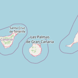
Map view of Betancuria Rural Park

Use this park location map to pinpoint Betancuria Rural Park in Spain, understand its exact geographic position, and read its mapped placement within the surrounding landscape more clearly.

Pigeon | © OpenStreetMap contributors

Location context for Betancuria Rural Park

Canarias

Visual reference collection highlighting ancient geological formations, deep barrancos, and protected island habitats.

Parque rural de Betancuria Photos and Landscape Scenery Exploration

Visual documentation captures the dramatic topography of the Betancuria Massif, ancient geological layers, and traditional agricultural terraces across Fuerteventura. Detailed imagery reveals the varied terrain, microhabitats, and protected landscape character that define the island interior.

A desert landscape featuring large, weathered sandstone rock formations surrounding a small, reflective pool of water with tall, dry grasses growing near the edge under a cloudy sky.

A wide, high-angle view showing a small village with white-walled buildings set in a deep valley surrounded by barren, reddish-brown volcanic mountain slopes under a clear blue sky.

A wide, eye-level photograph of a dry, rolling landscape with brownish hills under a blue sky with scattered white clouds, showing the sea in the distant background.

Park atlas

Compare surrounding regional geography and connected island conservation areas.

Parks Near Parque rural de Betancuria, Exploring Related Protected Landscapes

Browse other protected areas near Parque rural de Betancuria to examine contrasting volcanic terrain and coastal geology across the surrounding region. Extending the geographic comparison reveals broader regional park patterns and diverse island ecosystems.
Watercolor painting of a landscape with grassy areas, a winding river, and mountains under a light sky
National parkCanary Islands
About 67 km away#1 closest

Northeast

Timanfaya National Park: Dramatic Volcanic Landscape in the Canary Islands

Explore Spain's unique geological national park.

Timanfaya National Park offers an extraordinary exploration of volcanic terrain, a protected area that defines geological conservation in the Canary Islands. Its landscape, shaped by powerful eruptions, features vast lava fields, striking volcanic cones, and visible geothermal activity. As Spain's only purely geological national park, Timanfaya provides a unique context for understanding volcanic processes and appreciating the raw beauty of its protected natural environment, serving as a key landmark within the archipelago's geography.

Area
51.07 km²
Established
1974
IUCN
II
Relief
Mountain
A soft watercolor painting showing a rolling landscape with green hills, a small tree in the foreground, and pale blue mountains in the background.
Protected landscapeCanarias
About 154 km away#2 closest

West

Parque rural de Doramas Protected Landscape: Gran Canaria Geographic and Terrain Atlas

Exploring laurel forest strongholds and rugged ravine geography.

Parque rural de Doramas encompasses over 3,500 hectares of diverse northern Gran Canaria terrain, where steep-sided barrancos support rare laurisilva and monteverde vegetation. This protected landscape serves as a living remnant of the island's once-vast indigenous forests, offering a unique opportunity to study the relationship between human-influenced agricultural slopes and wild, humid forest refuges found deep within the island's northern flanks.

Area
35.86 km²
Relief
Upland
Climate
Mediterranean
Scope
Terrestrial
Watercolor painting of a light-filled landscape featuring soft green hills, clusters of pine trees, and distant ridgelines in muted pinks and purples.
Protected landscapeCanary Islands
About 159 km away#3 closest

West

Parque rural del Nublo: Volcanic Peaks and Protected Highland Terrain in Gran Canaria

Mapping the dramatic erosional landscapes and endemic ecosystems of central Gran Canaria.

Spanning the core of Gran Canaria, Parque rural del Nublo is a vast protected landscape characterized by its rugged volcanic topography. The area features the iconic Roque Nublo monolith, deeply incised barrancos, and a mosaic of pine forests and endemic scrubland. This territory represents a critical intersection of geological evolution and aboriginal history, containing major UNESCO-listed cultural sites within its complex highland boundaries.

Area
267.64 km²
Established
1994
IUCN
VI
Relief
Mountain
National parkWestern Sahara
About 180 km away#4 closest

East

Gulf of Khnifiss National Park: National Park in Western Sahara with Mapped Protected Boundaries

Explore the geographic context and landscape of this protected area.

Gulf of Khnifiss National Park is a designated national park offering vital insights into Western Sahara's protected landscapes. Its mapped boundaries and regional geography are crucial for understanding the park's ecological and cartographic significance within the atlas. Discover the essential characteristics that define this protected area's unique place in the natural terrain.

Watercolor painting depicting mountains, a body of water, and vegetation
National parkLaâyoune-Sakia El Hamra
About 180 km away#5 closest

East

Khenifiss National Park: A Protected Landscape within Laâyoune-Sakia El Hamra Region

Explore its mapped protected area and regional geography.

Khenifiss National Park offers a distinct entry into protected landscape exploration within the Laâyoune-Sakia El Hamra region. This park detail page provides core geographic context, focusing on its mapped boundaries and its significance as a protected natural area. Dive into the structured data that defines Khenifiss National Park, facilitating a deeper atlas-based understanding of its landscape and regional distribution.

Area
1,850 km²
Established
2006
IUCN
II
Relief
Lowland
Watercolor painting of soft, layered mountain ridges in shades of green, purple, and pale yellow, set against a white background.
Protected landscapeCanarias
About 201 km away#6 closest

West

Parque rural de Anaga: Mapping the Volcanic Relief and Laurisilva Forests of Canarias

A detailed geographic overview of the Anaga massif protected landscape.

Parque rural de Anaga preserves a dramatic landscape of volcanic plugs, deeply incised valleys, and endemic-rich cloud forests in the Canary Islands. Understand the complex terrain and protected area boundaries that define this historic massif, from its coastal cliffs to its high mountain ridges.

Area
144.187 km²
Established
1994
Relief
Mountain
Climate
Subtropical
Watercolor illustration of a mountainous landscape with green and purple hues, featuring rolling hills, distant mountains, and a light sky.
National parkTenerife
About 236 km away#7 closest

West

Teide National Park: Spain's Highest Peak and Distinctive Volcanic Landscape

Explore protected volcanic terrain and mapped geography on Tenerife.

Teide National Park protects the highest point in Spain, Mount Teide, within a spectacular caldera and surrounding volcanic terrain on Tenerife. This national park offers a unique landscape for geographic discovery, showcasing dramatic lava flows, volcanic cones, and endemic flora. Its protected boundaries define a significant area of natural interest, making it a key landmark for atlas exploration of island geography and protected lands.

Area
189.9 km²
Established
1954
IUCN
II
Visitors
4.5M annual
A soft watercolor painting depicting green rolling hills and layered mountain ridges against a white background.
Protected landscapeTenerife
About 266 km away#8 closest

West

Parque rural de Teno: Volcanic Massif and Protected Landscape Geography in Tenerife

Coastal cliffs, volcanic barrancos, and laurel forest ecosystems.

Parque rural de Teno serves as a primary geographic anchor for northwest Tenerife, encompassing a triangular volcanic block defined by vertical sea cliffs and steep, eroded ravines. This protected landscape preserves unique biodiversity and traditional cultural architecture, offering a comprehensive look at the island's geological and ecological variety from the shoreline to the mist-prone summits.

Area
80.636 km²
Established
1987
Relief
Mountain
Climate
Mediterranean

Common questions about visiting, size, designation, and location context for Betancuria Rural Park

Betancuria Rural Park FAQs for park facts, access, geography, and protected area context

Find quick answers about Betancuria Rural Park, including protected-area facts, park geography, trail and visitor context, and how the park fits into its surrounding country and regional landscape.
MoriAtlas Explorer

Continue Your Protected Areas Search Across the Global Atlas

Deepen your exploration by continuing the structured search for national parks and protected areas worldwide. Utilize the comprehensive filtering capabilities to compare different conservation landscapes and refine your understanding of global park geography. Discover more about the distribution and characteristics of protected natural areas.

Global natural geography