Mori Atlas logo
National parkTeide National Park

Discover the unique geography and mapped boundaries of this protected national park on Tenerife.

Teide National Park: Spain's Highest Peak and Dramatic Volcanic Landscape Atlas

(Parque nacional del Teide)

Teide National Park, situated in the central highlands of Tenerife, Spain, protects an extraordinary volcanic landscape centered on Mount Teide, the highest peak in Spain. This vast caldera and its surrounding dramatic terrain offer a unique window into planetary geology and protected island geography. As a key national park entity, it provides rich context for understanding Tenerife's unique natural features and contributes significantly to the atlas of protected lands.

volcanic landscapeUNESCO World Heritage Site Canary IslandsSpain's highest peakendemic floraMars analog research
Watercolor illustration showing Mount Teide with volcanic terrain, sparse vegetation, and a hiker on a trail

Teide National Park

National park

Park overview

Structured park overview, official facts, and landscape profile for Teide National Park

Teide National Park park facts, protected area profile, and essential visitor context
Review the core facts for Teide National Park, including designation, size, terrain, visitor scale, habitats, and operating context in one park-focused overview.

About Teide National Park

Teide National Park represents one of the world's most significant volcanic protected areas, centered on an iconic stratovolcano that dominates the island of Tenerife and serves as the defining geographical feature of the Canary Islands. The park's 18,990 hectares encompass a complete volcanic system including the Las Cañadas caldera, multiple volcanic cones, extensive lava fields, and the dramatic peaks of Mount Teide and Pico Viejo. This landscape represents a unique stage in volcanic evolution, with more evolved and differentiated magmas than the older basaltic volcanoes of Hawaii, making it scientifically complementary to Hawai'i Volcanoes National Park. The park's visitor numbers exceeding 4 million annually reflect its global appeal as a destination where people can experience the raw power and beauty of volcanic nature at close range. Beyond its natural significance, the park holds deep cultural meaning as a place of spiritual importance to the aboriginal Guanche people, who called the mountain Echeyde and believed it was the gate to hell. Thepark's astronomical observatory at 2,371 meters elevation has made Tenerife one of the world's important centers for solar and stellar research, with telescopes positioned on a ridge east of Teide contributing to significant astronomical discoveries.

Quick facts and research context for Teide National Park

Teide National Park is located on Tenerife, the largest of Spain's Canary Islands, in the Atlantic Ocean off the northwest African coast. The park was established on January 22, 1954, and was designated a UNESCO World Heritage Site in 2007 under criteria vii and viii for its outstanding natural value. The park lies within the municipality of La Orotava at elevations ranging from around 2,000 meters to the summit of Mount Teide at 3,718 meters. The climate is sunny, dry, and mild, with the Izaña Observatory recording nearly 3,500 sunshine hours annually. The park contains the Teide Observatory, one of Europe's important astronomical research facilities. The park is sister to Rapa Nui National Park on Easter Island, Chile.

Park context

Deeper park guide and search-rich context for Teide National Park

Teide National Park history, landscape, wildlife, and travel context
Explore Teide National Park through its history, landscape character, ecosystems, wildlife, conservation priorities, cultural context, and seasonal travel timing in a structured park guide built for atlas discovery and search intent.

Why Teide National Park stands out

Teide National Park is best known for protecting Mount Teide, Spain's highest mountain and one of the world's most distinctive volcanic landmarks. The park is renowned for its extraordinary volcanic landscape featuring the Las Cañadas caldera, the Roques de García rock formations, and dramatic lava flows that create a Mars-like terrain of global scientific importance. The park is famous for its unique endemic flora, including the striking red-flowered Teide bugloss that blooms in late spring, and the Teide violet that grows at the highest altitudes of any flowering plant in Spain. The park's significance as a testing ground for Mars exploration instruments has made it a landmark in planetary science research.

Desert-like volcanic terrain with scattered rocks, patches of snow, and distant mountains under a clear blue sky with scattered clouds.
Wide landscape view of Teide National Park featuring snow-dusted terrain and distant mountain ranges under a clear blue sky.

Teide National Park history and protected-area timeline

Teide National Park has held profound spiritual significance since pre-Hispanic times, when the aboriginal Guanches considered the mountain a sacred site and believed it was the gate to hell, naming it Echeyde. Archaeological sites discovered within the park reveal the historical importance of this volcanic landscape to the island's indigenous inhabitants. National park status was formally declared on January 22, 1954, making it the third oldest national park in Spain and the oldest in the Canary Islands. The Council of Europe awarded the park its European Diploma of Protected Areas in 1989, its highest category, with this recognition subsequently renewed in 1994, 1999, and 2004. In December 1999, the Spanish government expanded the park's boundaries by incorporating adjacent lands totaling 5,419 hectares, reaching the current surface area. After five years of effort, UNESCO declared Teide National Park a World Heritage Site on June 28, 2007, recognizing its outstanding universal value under natural criteria vii and viii. At the end of 2007, the park was also chosen as one of the 12 Treasures of Spain following a nationwide public vote.

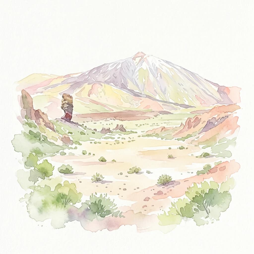
Teide National Park landscape and geographic character

The physical landscape of Teide National Park presents one of Europe's most dramatic volcanic terrains, characterized by the massive Las Cañadas caldera, a volcanic crater approximately 16 kilometers in diameter that serves as the park's central basin. Within this caldera and on its flanks rise the park's two dominant peaks: Mount Teide at 3,718 meters and Pico Viejo at 3,135 meters, the only two summits in the Canary Islands exceeding 3,000 meters. The Roques de García are iconic rock formations rising dramatically from the caldera floor, while features like the Alto de Guajara, Llano de Ucanca, and the Siete Cañadas add to the landscape's diversity. Numerous volcanic cones and lava flows from different eruptions create a complex terrain of stark beauty, with formations ranging from jagged peaks to smooth lava fields. The landscape changes dramatically with altitude and season, with winter snow often capping Teide's summit while the lower slopes remain bathed in sunshine. The striking contrast between the dark volcanic rocks and the often vivid blue sky defines the park's visual character.

Tall red flowering plant with spiky green leaves in a rocky, arid landscape.
Echium wildpretii plant in Teide National Park, Tenerife.

Teide National Park ecosystems, habitats, and plant life

The ecological character of Teide National Park is defined by extreme environmental conditions that have produced remarkable plant adaptations and high levels of endemism. Vascular flora includes 168 plant species, of which 33 are endemic to Tenerife, making the park botanically significant despite its harsh conditions. The Canary Island pine forest covers the middle slopes between 1,000 and 2,100 meters, with an alpine timberline approximately 1,000 meters lower than continental mountains at similar latitudes due to the island's isolation. Above the treeline, the Las Cañadas caldera provides sheltered conditions where more fragile species survive, including the Canary Island cedar and pine. The most dominant plant species include the Teide white broom with white and pink flowers, the Canary Island wallflower with white and violet blooms, and the spectacular Teide bugloss whose red flowers form pyramids up to three meters tall. The Teide daisy grows at altitudes approaching 3,600 meters, while the Teide violet found at the volcano's summit represents the highest flowering plant in Spain. These species have evolved remarkable adaptations including semi-spherical forms, waxy or downy coverings, reduced leaf area, and high flower production to survive intense sunlight, extreme temperature variations, and drought conditions.

A volcanic mountain peak rises above a layer of clouds with clear blue sky above, showing the distinctive reddish-brown terrain of Teide National Park
Mount Teide peak rising above the cloud layer in Teide National Park

Teide National Park wildlife and species highlights

Wildlife in Teide National Park presents an interesting pattern of limited vertebrate diversity paired with remarkable invertebrate richness. The park supports over 40% endemic invertebrate species, with 70 species found nowhere else on Earth, including spiders, beetles, dipterans, hemipterans, and hymenopterans. Vertebrate fauna is more limited, with only ten bird species nesting within the park. Notable avian residents include the Tenerife blue chaffinch, Berthelot's pipit, the Atlantic canary, and a subspecies of kestrel. Three endemic reptile species inhabit the park: the Canary Island lizard, the Canary Island wall gecko, and the Canary Island skink. The only mammals native to the park are bats, with Leisler's bat being the most common species. Several mammals including mouflon, rabbit, house mouse, black rat, feral cat, and Algerian hedgehog have been introduced to the park over time.

Winding dirt trail on rocky volcanic terrain with sea of clouds below under clear blue sky
Winding trail through volcanic terrain with sea of clouds at Teide National Park

Teide National Park conservation status and protection priorities

Teide National Park holds significant conservation importance as both a European and global protected area, recognized through multiple prestigious designations. The park's UNESCO World Heritage inscription in 2007 acknowledges its outstanding universal value as a natural site of global significance. The European Diploma of Protected Areas awarded by the Council of Europe in 1989 and repeatedly renewed represents the highest level of conservation recognition in Europe. The park is part of the Natura 2000 network and contains 11 habitats of interest community covering 75% of its surface area. The park's conservation value is enhanced by its role as a refuge for 33 endemic plant species, three of which are listed as endangered and twelve as vulnerable under Spain's National Catalogue of Threatened Species. The park's selection as a Mars analog testing site by space agencies reflects the scientific community's recognition of its unique geological and environmental conditions, positioning it as an important site for planetary science research that further elevates its conservation priority.

Teide National Park cultural meaning and human context

Teide National Park carries deep cultural significance rooted in the island's pre-Hispanic past. The aboriginal Guanche people, Tenerife's indigenous inhabitants, held Mount Teide in reverence as a sacred mountain they called Echeyde, meaning the dwelling of Guayota, the evil spirit they associated with the volcano's fires. According to Guanche legend, Guayota kidnapped the sun god Magec and imprisoned him inside the volcano, plunging the island into darkness until the supreme god Achamán defeated the evil spirit and sealed the volcano's mouth. The park contains important archaeological sites that reveal the Guanches' relationship with this landscape, which served as a seasonal resource for grazing their flocks during summer months. The park also contains the highest Christian church in Spain, a small chapel dedicated to the Virgen de las Nieves that stands near the Parador de Las Cañadas, reflecting the continuing human presence in this volcanic landscape.

Wide view of Mount Teide with snow-capped peak against clear blue sky, showing volcanic landscape below
Mount Teide rises prominently within Teide National Park, Spain

Top sights and standout views in Teide National Park

Teide National Park offers visitors the experience of Spain's highest peak, spectacular volcanic landscapes resembling a Martian environment, and some of the clearest skies in Europe for stargazing. The Teide Observatory operates at 2,371 meters, making Tenerife a world center for astronomical research. The park serves as a living laboratory for space science, having been used to test instruments destined for Mars missions including the ExoMars expedition. The striking red blooms of the Teide bugloss in May and June create one of the Canary Islands' most memorable wildflower displays. Rock formations like the Roques de García and the distinctive Roque Cinchado have made the park a popular filming location for productions ranging from One Million Years B.C. to Clash of the Titans. The park has been a training ground for elite cyclists seeking altitude conditioning in stable weather conditions.

Small adobe-style building with stone accents and a bell tower in a volcanic landscape with Mount Teide visible on the horizon under a clear blue sky
Hermitage of Our Lady of the Snows in Teide National Park with Mount Teide visible in the background under clear blue sky

Best time to visit Teide National Park

Teide National Park can be visited year-round due to its generally sunny, dry, and mild climate, though the experience varies considerably by season. Summer brings the most stable weather with almost completely clear skies, though this is also the busiest period with highest visitor numbers. Late spring, particularly May and June, offers the park's most spectacular floral display when the Teide bugloss and other endemic species bloom, creating vivid red and white carpets across the landscape. Winter can bring snow to the upper elevations, transforming the landscape into a dramatically different scene while attracting fewer visitors, though access to higher elevations may be restricted during adverse weather. The Izaña Observatory records an average annual temperature of 10.2°C, with summer highs around 23°C and winter lows occasionally dropping below -9°C at the summit. For those seeking the best balance of good weather, fewer crowds, and the flowering season, late April through June represents an ideal visiting period.

Park location guide

Geography guide, regional context, and park location map for Teide National Park

Teide National Park park geography, regions, and map view in Spain
Understand where Teide National Park sits in Spain through a broader geographic reading of the surrounding landscape, nearby location context, and its mapped position within the national park landscape.

How Teide National Park fits into Spain

Spain, officially the Kingdom of Spain, is a unitary parliamentary constitutional monarchy located in Southern and Western Europe. The country occupies most of the Iberian Peninsula and includes territories in the Mediterranean and Atlantic. With a population of approximately 49.6 million and an area of 506,030 km², Spain is a major European economy and cultural force. Its capital is Madrid, and the country is known for its diverse landscapes ranging from mountainous regions to coastal areas.

Wider geography shaping Teide National Park in Spain

Spain occupies the Iberian Peninsula in Southern and Western Europe. Peninsular Spain is bordered to the north by France, Andorra, and the Bay of Biscay; to the east and south by the Mediterranean Sea and Gibraltar; and to the west by Portugal and the Atlantic Ocean. The territory includes the Canary Islands in the Atlantic Ocean, the Balearic Islands in the Mediterranean Sea, and the autonomous cities of Ceuta and Melilla in mainland Africa. Spain features diverse terrain including the Pyrenees in the northeast, the Sierra Nevada in the south, and the Meseta Central plateau.

Map view of Teide National Park

Use this park location map to pinpoint Teide National Park in Spain, understand its exact geographic position, and read its mapped placement within the surrounding landscape more clearly.

Pigeon | © OpenStreetMap contributors

Location context for Teide National Park

Tenerife

Mapped Visuals Revealing Teide's Dramatic Volcanic Terrain, Unique Habitats, and Iconic Protected Landscape

Visual Exploration: Teide National Park Photos, Landscapes, and Volcanic Scenery
Browse a curated collection of Teide National Park images to visually comprehend its dramatic volcanic terrain, unique geological formations, and distinctive high-altitude environments. These photographs provide essential insights into the park's iconic Mount Teide, its Mars-like landscapes, and the endemic flora that thrives within this protected area.

Desert-like volcanic terrain with scattered rocks, patches of snow, and distant mountains under a clear blue sky with scattered clouds.

Wide landscape view of Mount Teide volcano and Cañadas del Teide caldera with rocky terrain under clear blue sky

Tall red flowering plant with spiky green leaves in a rocky, arid landscape.

A volcanic mountain peak rises above a layer of clouds with clear blue sky above, showing the distinctive reddish-brown terrain of Teide National Park

Winding dirt trail on rocky volcanic terrain with sea of clouds below under clear blue sky

Volcanic landscape with rocky formations, sparse vegetation, and mountainous terrain under clear blue sky

Wide view of Mount Teide with snow-capped peak against clear blue sky, showing volcanic landscape below

Small adobe-style building with stone accents and a bell tower in a volcanic landscape with Mount Teide visible on the horizon under a clear blue sky

Tall red flowering plants with white spiky bases growing in rocky terrain with forested hills in the background

Rock formations with sparse vegetation under clear blue sky in Teide National Park

Mount Teide with snow on its peak, rocky terrain and pine trees in the foreground, clear blue sky background

Panoramic view of Teide National Park with Mount Teide (Pico del Teide) in the background, arid landscape, and clear blue sky

Panoramic view of rocky volcanic rock formations and arid terrain in Teide National Park, Canary Islands.

Tall weathered rock formation (Roque Cinchado) on rocky terrain with Mount Teide mountain visible under clear blue sky

Volcanic crater landscape with rocky terrain, a trail on the right, and distant ocean with La Gomera island visible

Cable car suspended on cables above barren volcanic landscape with mountain peaks under clear blue sky

Park atlas

Trace surrounding landscapes and compare protected area geography across the Canary Islands region

Explore Nearby National Parks and Protected Areas Beyond Teide National Park
Continue your exploration of volcanic national parks and other protected areas, tracing unique island ecosystems and diverse conservation landscapes across the Canary Islands region. Compare how nearby protected zones complement Teide National Park's features, offering a broader geographic understanding of the region's natural heritage.
National park

Garajonay National Park: Ancient Laurisilva Forest and Volcanic Landscapes

Explore Spain's unique protected area with rich geographic context.

Garajonay National Park, a treasure of La Gomera, preserves one of the last stands of Europe's ancient laurisilva forest atop dramatic volcanic terrain. This national park offers a rare opportunity to explore a landscape shaped by persistent cloud cover and unique island evolution. Examine the park's mapped boundaries and distinctive natural features through its detailed geographic profile.

Area
40 km²
Established
1981
IUCN
II
Visitors
450K annual
Watercolor illustration showing a mountainous landscape with green forests, a winding river, and distant hills
National park

Caldera de Taburiente National Park: National Park & Geological Heritage Site

Explore its volcanic caldera, mapped ravines, and pine forests.

Caldera de Taburiente National Park is a protected natural area on the island of La Palma, Spain. It encompasses a vast, approximately 10-kilometer-wide volcanic caldera, characterized by immense cliffs, deep ravines, and extensive Canary Island Pine forests. This national park is recognized for its significant geological features and unique landscape, making it a key destination for understanding protected area geography and regional natural heritage.

Area
46.9 km²
Established
1954
IUCN
II
Visitors
389K annual
Watercolor painting of a landscape with grassy areas, a winding river, and mountains under a light sky
National parkCanary Islands

Timanfaya National Park: Dramatic Volcanic Landscape in the Canary Islands

Explore Spain's unique geological national park.

Timanfaya National Park offers an extraordinary exploration of volcanic terrain, a protected area that defines geological conservation in the Canary Islands. Its landscape, shaped by powerful eruptions, features vast lava fields, striking volcanic cones, and visible geothermal activity. As Spain's only purely geological national park, Timanfaya provides a unique context for understanding volcanic processes and appreciating the raw beauty of its protected natural environment, serving as a key landmark within the archipelago's geography.

Area
51.07 km²
Established
1974
IUCN
II
Relief
Mountain
Watercolor painting depicting mountains, a body of water, and vegetation
National parkLaâyoune-Sakia El Hamra

Khenifiss National Park: A Protected Landscape within Laâyoune-Sakia El Hamra Region

Explore its mapped protected area and regional geography.

Khenifiss National Park offers a distinct entry into protected landscape exploration within the Laâyoune-Sakia El Hamra region. This park detail page provides core geographic context, focusing on its mapped boundaries and its significance as a protected natural area. Dive into the structured data that defines Khenifiss National Park, facilitating a deeper atlas-based understanding of its landscape and regional distribution.

Area
1,850 km²
Established
2006
IUCN
II
Relief
Lowland
National parkMorocco

Souss-Massa National Park: Moroccan Coastal Protected Landscape and Geographic Map

Explore vital protected areas and mapped natural terrain on the Atlantic coast.

Souss-Massa National Park is a critical national park situated along the Atlantic coast of Morocco. This protected landscape offers a unique atlas-style view of its diverse geography, including vital wetlands, sand dunes, and coastal steppe. Delve into the mapped boundaries and understand the park's ecological significance within Morocco's regional landscape context.

Area
338 km²
Established
1991
IUCN
II
Relief
Lowland
National parkMauritania

Banc d'Arguin National Park: Mauritania's National Park Geography and Mapped Boundaries

Explore the geographic identity and protected landscape.

Investigate Banc d'Arguin National Park, a significant national park located in Mauritania. This detailed page offers insights into its protected landscape, mapped geographic features, and its regional context. Understand the specific park boundaries and how the area contributes to the atlas of protected lands in Northwest Africa.

Area
12,000 km²
Established
1976
IUCN
II
Relief
Lowland
National parkMorocco

Toubkal National Park: Morocco's Key Protected National Park for Geographic Exploration

Mapped boundaries and regional landscape context within Morocco.

Toubkal National Park stands as a significant protected area within Morocco, offering a lens through which to explore its diverse natural geography and protected landscapes. This national park designation signifies its importance for understanding the country's conservation efforts and its mapped territorial integrity. Users can discover the park's unique geographic attributes and its role within the larger atlas of Moroccan protected lands, providing foundational context for further geographic discovery.

Area
380 km²
Established
1942
IUCN
II
Relief
Mountain
National parkMorocco

Haut Atlas Oriental National Park: National Park Mapping and Protected Landscape Identity

Explore its mapped geography and regional atlas context.

Delve into the specifics of Haut Atlas Oriental National Park, a designated national park in Morocco. This page serves as a detailed atlas entry, focusing on the park's protected landscape characteristics, its defined geographic boundaries, and its significance within the national park system. Understand the terrain and regional context that shape this important natural area for focused discovery.

Area
490 km²
IUCN
II
Relief
Mountain
Climate
Alpine

Common questions about visiting, size, designation, and location context for Teide National Park

Teide National Park FAQs for park facts, access, geography, and protected area context
Find quick answers about Teide National Park, including protected-area facts, park geography, trail and visitor context, and how the park fits into its surrounding country and regional landscape.
MoriAtlas Explorer

Continue Your Protected Areas Search Across the Global Atlas

Deepen your exploration by continuing the structured search for national parks and protected areas worldwide. Utilize the comprehensive filtering capabilities to compare different conservation landscapes and refine your understanding of global park geography. Discover more about the distribution and characteristics of protected natural areas.

Global natural geography