

Mori Atlas logo
National parkToubkal National Park

Discover the mapped boundaries and regional geographic context of this protected Moroccan national park.

Toubkal National Park: Morocco National Park Protected Landscape and Geographic Atlas

Toubkal National Park represents a significant protected area within the geographic atlas of Morocco, offering a dedicated space for understanding mapped natural landscapes. As a designated national park, it serves as a focal point for exploring the country's protected lands and their regional context. This page provides a structured entry into the park's identity, its place within Morocco's broader geography, and the atlas-driven insights available for its protected landscape.

mountain national parkHigh AtlasNorth Africasummit trekkingIUCN Category IIprotected area

Toubkal National Park

National park

Park overview

Structured park overview, official facts, and landscape profile for Toubkal National Park

Toubkal National Park park facts, protected area profile, and essential visitor context
Review the core facts for Toubkal National Park, including designation, size, terrain, visitor scale, habitats, and operating context in one park-focused overview.

About Toubkal National Park

Toubkal National Park represents the premier mountain protected area in Morocco and serves as the ecological backbone of the High Atlas region. The park's establishment in 1942 reflected early recognition of the need to preserve the unique Atlas mountain environment and its remarkable biodiversity. Today, the park continues to function as both a conservation refuge and a living landscape where traditional Berber mountain communities maintain their centuries-old relationship with the land. Visitors to the park typically enter through the village of Imlil, which has developed as a trekking hub where visitors can arrange guides and mule support for ascents into the high mountains. The park's trails pass through terraced fields, ancient cedar and juniper forests, and boulder-strewn alpine terrain before reaching the rocky summit of Toubkal. The ecomuseum within the park provides educational context about ongoing conservation projects focused on protecting endangered species and sustaining the ecological integrity of this mountainous wilderness.

Quick facts and research context for Toubkal National Park

Toubkal National Park occupies the central High Atlas mountains in central-western Morocco, about 70 kilometers from Marrakesh. The park was established in 1942, making it one of Africa's older protected areas. It covers approximately 380 square kilometers and contains several peaks exceeding 3,500 meters, with Jbel Toubkal being the highest point in North Africa at 4,167 meters. The park has been designated an Important Bird Area by BirdLife International due to its significant populations of mountain-adapted bird species. The Berber village of Imlil serves as the primary gateway and base for visitors exploring the park.

Park context

Deeper park guide and search-rich context for Toubkal National Park

Toubkal National Park history, landscape, wildlife, and travel context
Explore Toubkal National Park through its history, landscape character, ecosystems, wildlife, conservation priorities, cultural context, and seasonal travel timing in a structured park guide built for atlas discovery and search intent.

Why Toubkal National Park stands out

Toubkal National Park is best known for hosting Jbel Toubkal, the roof of North Africa and the highest peak on the continent outside the Sahara. The park offers one of the most accessible high-altitude wilderness experiences in Africa, with trekking routes that ascend from traditional Berber villages through changing ecosystems to glacier-circled summits. The dramatic contrast between the arid valleys and the snow-capped peaks creates a striking landscape that defines the High Atlas. The park also contains the ecomuseum showcasing conservation efforts and the cultural heritage of the Berber communities who have inhabited these mountains for centuries.

Toubkal National Park history and protected-area timeline

Toubkal National Park was established in 1942, making it one of the earliest national parks on the African continent. Its creation reflected the colonial-era recognition that the High Atlas mountains contained irreplaceable natural and scenic values requiring formal protection. Over the decades, the park has maintained its protective status while evolving its management approaches to balance conservation with the needs of local Berber communities. In October 2012, the park gained notoriety when Salafists were blamed for destroying an 8,000-year-old petroglyph that depicted the Sun as a divinity, highlighting the park's archaeological significance beyond its ecological value. The park continues to operate under IUCN Category II protection, reflecting its status as a genuine national park where conservation of natural ecosystems takes precedence.

Toubkal National Park landscape and geographic character

The landscape of Toubkal National Park is defined by dramatic alpine terrain rising from the High Atlas massif. The park contains a remarkable collection of peaks exceeding 3,500 meters, with Toubkal at 4,167 meters standing as the highest, followed by Ouanoukrim at 4,089 meters, Plateau de Tazarhart at 3,995 meters, L'Aksoual at 3,910 meters, Ineghbar at 3,892 meters, Bou Iguenouane at 3,882 meters, Le Tichki at 3,753 meters, and Azrou Tamadout at 3,664 meters. Between these peaks lie broad cirques, steep-walled valleys, and rocky ridges that create the characteristic High Atlas scenery. The lower elevations feature terraced cultivation pockets and villages, while middle slopes support forests of cedar oak and juniper before giving way to sparse alpine vegetation and permanent snow fields at the highest elevations.

Toubkal National Park ecosystems, habitats, and plant life

The ecological character of Toubkal National Park derives from its remarkable elevational range and position at the crossroads of Mediterranean and African biogeographic influences. The park's vegetation zones transition from arid valley scrub through dense cedar-juniper forests to sparse alpine communities capable of surviving in the harsh conditions above 3,000 meters. This vertical zonation creates a compressed representation of ecological diversity that would require traveling thousands of kilometers across latitude to experience elsewhere. The park's designation as an Important Bird Area acknowledges its role as a critical habitat for species adapted to the unique conditions of High Atlas mountains, where bird communities differ substantially from both European and sub-Saharan African faunas.

Toubkal National Park wildlife and species highlights

Toubkal National Park supports a distinctive bird community characteristic of High Atlas environments. As an Important Bird Area designated by BirdLife International, the park provides habitat for significant populations of Barbary partridges, Levaillant's woodpeckers, and several warbler species including subalpine warbler, Sardinian warbler, spectacled warbler, and Tristram's warbler. The park also supports Moussier's redstart, black-eared wheatear, and black wheatear, species that thrive in the rocky mountain terrain. Beyond avifauna, the park's forests and alpine zones host various mammals adapted to the High Atlas environment, though the source material focuses primarily on the bird communities that have earned the park its IBA designation.

Toubkal National Park conservation status and protection priorities

Toubkal National Park holds significant conservation value as the premier protected area in the High Atlas and one of Morocco's oldest national parks. The park's designation as an Important Bird Area by BirdLife International recognizes its global importance for conservation of mountain bird species. Protecting the High Atlas ecosystem preserves not only unique biodiversity but also critical watersheds that feed downstream agricultural regions. The park's ecomuseum highlights ongoing sustainability and protection projects for endangered species, reflecting active management rather than passive protection. The 2012 destruction of an ancient petroglyph within the park boundaries also underscored the need to protect archaeological heritage alongside natural resources.

Toubkal National Park cultural meaning and human context

The cultural landscape of Toubkal National Park is inseparable from the Berber communities who have inhabited the High Atlas mountains for generations. The village of Imlil serves as the primary access point for visitors entering the park and offers immersion in traditional Berber mountain life. These communities have developed intimate knowledge of the high-altitude environment, maintaining terraced agriculture and pastoral practices adapted to the challenging conditions. The ecomuseum within the park showcases the intertwined history of human habitation and natural landscape in the High Atlas, emphasizing how conservation efforts must account for the legitimate needs of local communities whose cultural survival depends on sustainable use of mountain resources.

Top sights and standout views in Toubkal National Park

Toubkal National Park offers the singular experience of standing on the highest point in North Africa, with Jbel Toubkal's 4,167-meter summit providing a tangible goal for mountaineers. The two-day trek to the summit passes through progressively changing landscapes, from cultivated valleys through forests to alpine terrain, offering a condensed alpine experience accessible to motivated hikers. The Berber village of Imlil provides cultural entry point and logistical support, while the park's ecomuseum offers educational context about conservation work. Spring brings flowery landscapes to the lower elevations, while autumn paints the cedar and juniper forests in rich colors, offering distinct seasonal characters for visitors.

Best time to visit Toubkal National Park

The most favorable time to visit Toubkal National Park spans from late spring through early autumn, with May through September offering the most reliable conditions for high-altitude trekking. Spring brings flowering meadows and flowing water in the valley streams, creating verdant conditions that contrast with the rocky peaks above. Autumn offers the characteristic color change of the cedar and juniper forests as leaves turn, along with typically stable weather conditions. Summer months bring the warmest conditions at lower elevations but remain cool at altitude, though the high-altitude terrain can experience sudden weather changes. Winter conditions make the higher peaks inaccessible and can close trails, though the park remains open for lower-elevation exploration.
Park location guide

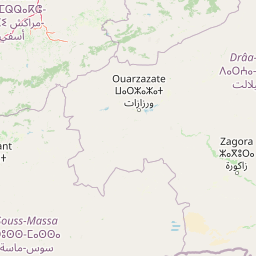
Geography guide, regional context, and park location map for Toubkal National Park

Toubkal National Park park geography, regions, and map view in Morocco
Understand where Toubkal National Park sits in Morocco through a broader geographic reading of the surrounding landscape, nearby location context, and its mapped position within the national park landscape.

How Toubkal National Park fits into Morocco

Morocco is a North African country bordering the Mediterranean Sea to the north and Atlantic Ocean to the west. It borders Algeria to the east and the disputed Western Sahara territory to the south. The country operates as a parliamentary constitutional monarchy under King Mohammed VI, with Arabic and Tamazight as official languages. Morocco has a population of approximately 37 million and covers an area of about 446,550 km².

Wider geography shaping Toubkal National Park in Morocco

Morocco occupies the northwestern corner of Africa, bordering the Mediterranean Sea to the north and Atlantic Ocean to the west. The country shares borders with Algeria to the east and the disputed Western Sahara territory to the south. The terrain is diverse, featuring the Atlas Mountains in the central and southern regions, Rif Mountains in the north, and plains along the coastal areas. The country also claims Spanish exclaves of Ceuta and Melilla.

Map view of Toubkal National Park

Use this park location map to pinpoint Toubkal National Park in Morocco, understand its exact geographic position, and read its mapped placement within the surrounding landscape more clearly.

Pigeon | © OpenStreetMap contributors

Location context for Toubkal National Park

High Atlas
Park atlas

Compare the diverse mountain and alpine protected landscapes geographically adjacent to Toubkal National Park.

Explore Nearby Protected Areas and National Parks Surrounding Toubkal National Park
After exploring Toubkal National Park, browse other significant national parks and protected areas within its regional context across the High Atlas mountains and North Africa. Continue your atlas-style discovery by mapping nearby landscapes, comparing their conservation profiles, and tracing the geographic spread of protected environments.
National parkMorocco

Souss-Massa National Park: Moroccan Coastal Protected Landscape and Geographic Map

Explore vital protected areas and mapped natural terrain on the Atlantic coast.

Souss-Massa National Park is a critical national park situated along the Atlantic coast of Morocco. This protected landscape offers a unique atlas-style view of its diverse geography, including vital wetlands, sand dunes, and coastal steppe. Delve into the mapped boundaries and understand the park's ecological significance within Morocco's regional landscape context.

Area
338 km²
Established
1991
IUCN
II
Relief
Lowland
National parkMorocco

Haut Atlas Oriental National Park: National Park Mapping and Protected Landscape Identity

Explore its mapped geography and regional atlas context.

Delve into the specifics of Haut Atlas Oriental National Park, a designated national park in Morocco. This page serves as a detailed atlas entry, focusing on the park's protected landscape characteristics, its defined geographic boundaries, and its significance within the national park system. Understand the terrain and regional context that shape this important natural area for focused discovery.

Area
490 km²
IUCN
II
Relief
Mountain
Climate
Alpine
National parkMorocco

Khenifra National Park: National Park Atlas and Mapped Protected Landscape

Geographic context and protected area mapping for Morocco.

Explore the atlas perspective of Khenifra National Park, a designated national park in Morocco. This page provides detailed geographic context, focusing on its mapped protected landscape and its role within the country's network of conservation areas. Understand the park's terrain and regional setting through structured geographic data.

Area
842 km²
Established
2008
Relief
Mountain
Climate
Mediterranean
National parkMorocco

Ifrane National Park: Protected Landscape and Geographic Context in Morocco

National park boundaries and mapped terrain.

Investigate Ifrane National Park, a designated national park in Morocco, and its contribution to the country's protected lands. This profile details its geographic location, providing context for its mapped presence and the natural landscapes it encompasses. Delve into the atlas-relevant features that define this protected area, focusing on its geographic identity within Morocco's natural heritage.

Area
500 km²
Established
2004
IUCN
II
Relief
Mountain
National parkTaza Province

Tazekka National Park: Protected Landscape and Geographic Context in Taza Province

Discover its national park status and mapped terrain.

Tazekka National Park serves as a vital protected area within the geographic framework of Taza Province, Morocco. This national park offers a distinct landscape for exploration, allowing users to investigate its mapped boundaries and regional natural features. Understand the park's role in the local geography and its contribution to Morocco's atlas of protected lands. Its specific terrain and setting make it a key point for structured geographic discovery.

Area
120 km²
Established
1950
IUCN
II
Relief
Mountain
Watercolor painting depicting mountains, a body of water, and vegetation
National parkLaâyoune-Sakia El Hamra

Khenifiss National Park: A Protected Landscape within Laâyoune-Sakia El Hamra Region

Explore its mapped protected area and regional geography.

Khenifiss National Park offers a distinct entry into protected landscape exploration within the Laâyoune-Sakia El Hamra region. This park detail page provides core geographic context, focusing on its mapped boundaries and its significance as a protected natural area. Dive into the structured data that defines Khenifiss National Park, facilitating a deeper atlas-based understanding of its landscape and regional distribution.

Area
1,850 km²
Established
2006
IUCN
II
Relief
Lowland
Watercolor illustration showing a landscape with green hills, vegetation, and distant mountains
National parkMorocco

Al Hoceima National Park: Morocco's Coastal and Marine Protected Wilderness

Explore dramatic cliffs, kelp forests, and marine biodiversity.

Al Hoceima National Park represents a significant protected coastal and marine area in northern Morocco, distinguished by its rugged 50-kilometer Mediterranean coastline featuring spectacular limestone cliffs. This national park offers an atlas-style view of a landscape transitioning from the Ibaqouyen Rif mountains to the sea, harboring rich marine biodiversity including significant osprey colonies and dolphin habitats. Discover the mapped extent of this wild protected territory and its unique ecological features.

Area
480 km²
Established
2004
IUCN
II
Relief
Mountain
Watercolor painting of a landscape with grassy areas, a winding river, and mountains under a light sky
National parkCanary Islands

Timanfaya National Park: Dramatic Volcanic Landscape in the Canary Islands

Explore Spain's unique geological national park.

Timanfaya National Park offers an extraordinary exploration of volcanic terrain, a protected area that defines geological conservation in the Canary Islands. Its landscape, shaped by powerful eruptions, features vast lava fields, striking volcanic cones, and visible geothermal activity. As Spain's only purely geological national park, Timanfaya provides a unique context for understanding volcanic processes and appreciating the raw beauty of its protected natural environment, serving as a key landmark within the archipelago's geography.

Area
51.07 km²
Established
1974
IUCN
II
Relief
Mountain

Common questions about visiting, size, designation, and location context for Toubkal National Park

Toubkal National Park FAQs for park facts, access, geography, and protected area context
Find quick answers about Toubkal National Park, including protected-area facts, park geography, trail and visitor context, and how the park fits into its surrounding country and regional landscape.
MoriAtlas Explorer

Continue Your Protected Areas Search Across the Global Atlas

Deepen your exploration by continuing the structured search for national parks and protected areas worldwide. Utilize the comprehensive filtering capabilities to compare different conservation landscapes and refine your understanding of global park geography. Discover more about the distribution and characteristics of protected natural areas.

Global natural geography