Mori Atlas logo
National parkHaut Atlas Oriental National Park

Discover the mapped geography and protected area boundaries of this national park.

Haut Atlas Oriental National Park: A Protected Landscape in Morocco's Atlas Mountains

(Parc National du Haut Atlas Oriental)

Haut Atlas Oriental National Park stands as a significant protected natural area within Morocco's diverse geography. As a designated national park, it offers a unique window into the country's landscapes, featuring mapped boundaries and specific regional terrain. This dedicated entry provides a foundational understanding of the park's protected status and its role within the broader Moroccan atlas, inviting detailed geographic exploration of its natural context.

Morocco national parksHigh Atlas mountainsCedar forestsRamsar sitesBerber cultural heritageMediterranean mountain ecosystems

Haut Atlas Oriental National Park

National park

Park overview

Structured park overview, official facts, and landscape profile for Haut Atlas Oriental National Park

Haut Atlas Oriental National Park park facts, protected area profile, and essential visitor context
Review the core facts for Haut Atlas Oriental National Park, including designation, size, terrain, visitor scale, habitats, and operating context in one park-focused overview.

About Haut Atlas Oriental National Park

Haut Atlas Oriental National Park occupies a significant portion of Morocco's eastern High Atlas mountains, representing one of the kingdom's key protected areas for high-altitude Mediterranean ecosystems. The park's geography is characterized by dramatic topographic variation, with limestone base rock punctuated by igneous intrusions creating a rugged mountain landscape. Elevation ranges from 1,645 meters along the Oued Arheddou riverbed to 3,102 meters at Jbel Tanrhourt summit, creating diverse microclimates and habitat zones within a relatively compact area. The park's location between Midelt and Er Rachidia places it at the heart of Morocco's mountainous interior, far from the more visited coastal and plain regions. The park's dual mission of preserving both natural and cultural values distinguishes it from strictly ecological reserves, acknowledging that the region's biodiversity has developed in concert with human communities over generations. Local Berber populations have maintained traditional agricultural and pastoral practices that shape both the landscape and the cultural fabric of the area.

Quick facts and research context for Haut Atlas Oriental National Park

Haut Atlas Oriental National Park occupies 490 square kilometers in Morocco's eastern High Atlas, protecting a mountainous landscape that rises from 1,645 meters to 3,102 meters at Jbel Tanrhourt. The park was established to safeguard both ecological and cultural values, with parts designated as a Ramsar wetland site in 2005. The northern slopes support dense cedar and pine forests receiving 400-600mm annual rainfall, while the drier southern slopes feature steppe vegetation. The park contains the twin lakes of Isli and Tislit near Imilchil and lies within a region traditionally inhabited by Berber communities.

Park context

Deeper park guide and search-rich context for Haut Atlas Oriental National Park

Haut Atlas Oriental National Park history, landscape, wildlife, and travel context
Explore Haut Atlas Oriental National Park through its history, landscape character, ecosystems, wildlife, conservation priorities, cultural context, and seasonal travel timing in a structured park guide built for atlas discovery and search intent.

Why Haut Atlas Oriental National Park stands out

Haut Atlas Oriental National Park is best known for its dramatic transition from dense cedar and pine forests on wetter northern slopes to open juniper steppe on drier southern slopes, all within a single protected area. The twin lakes of Isli and Tislit near Imilchil represent the park's most iconic landscape feature, while the area's cultural significance stems from its location within traditional Berber territory and the famous Imilchil Marriage Festival. The park's status as an Important Bird Area and the presence of species including Barbary sheep, Cuvier's gazelle, and Barbary macaques further distinguish its ecological character.

Haut Atlas Oriental National Park history and protected-area timeline

Haut Atlas Oriental National Park was formally established to protect the significant natural and cultural values of Morocco's eastern High Atlas region. The park's designation as a Ramsar site in 2005, under the official name Lacs Isly-Tislite, recognized the importance of its wetland components, particularly the twin lakes of Isli and Tislit. This international recognition under the Ramsar Convention added a layer of protection to the area's aquatic ecosystems and reinforced Morocco's commitment to preserving important wetland habitats. The park's creation acknowledged that conservation in this region cannot be separated from the cultural practices of the Berber communities who have inhabited these mountains for generations, leading to a management approach that seeks to balance ecological preservation with recognition of traditional land use.

Haut Atlas Oriental National Park landscape and geographic character

The landscape of Haut Atlas Oriental National Park is defined by its dramatic mountain terrain within the High Atlas range. The park encompasses elevations spanning nearly 1,500 meters, from valley floors at 1,645 meters to the summit of Jbel Tanrhourt at 3,102 meters. Limestone forms the predominant base rock, with igneous intrusions adding geological variety to the terrain. The twin lakes of Isli and Tislit, located near the village of Imilchil at the park's western end, represent the most distinctive surface water features and contribute significantly to the area's scenic character. The park's topography creates a sharp ecological division between its northern and southern slopes, with the wetter northern aspects supporting forest cover while the drier southern slopes transition into open steppe. Winter snow accumulates abundantly at higher elevations, contributing to seasonal landscape changes and serving as an important water source for downstream areas.

Haut Atlas Oriental National Park ecosystems, habitats, and plant life

The nature of Haut Atlas Oriental National Park displays remarkable diversity across its relatively compact area, shaped primarily by the stark precipitation differences between northern and southern slopes. The northern aspects receive 400-600mm of annual rainfall, supporting dense forests of Atlas cedar and Moroccan pine, as well as oak woodland and open juniper stands. At lower elevations, Aleppo pine appears in scattered formations. The higher elevations and plateaus support xerophytic steppe vegetation adapted to harsher conditions, with some grassland in wetter microsites. The southern slopes, receiving only 200-300mm annually, feature more open vegetation where cedar woodland has largely disappeared, replaced by sparse oak and pine stands with steppe vegetation dominated by Stipa tenacissima at lower altitudes. This gradient from humid forest to arid steppe within a single protected area makes the park a valuable example of Mediterranean mountain ecology.

Haut Atlas Oriental National Park wildlife and species highlights

Haut Atlas Oriental National Park supports significant wildlife populations across multiple taxonomic groups, justifying its designation as an Important Bird Area by BirdLife International. The park's bird communities include notable species such as Barbary partridge, Levaillant's woodpecker, subalpine warbler, spectacled warbler, and Tristram's warbler. Moussier's redstart and both black-eared and black wheatears are also present, representing the diverse avifauna adapted to the park's various habitat zones. Mammalian fauna includes Barbary sheep, Cuvier's gazelle, and Barbary macaques, the latter representing an important population of this endangered primate species. Historically, leopards inhabited the region, though confirmed records have been absent since 1993, suggesting possible local extinction. The park's varied elevation zones and habitat types create conditions supporting this biological diversity, from forest-dwelling species to those adapted to open mountain terrain.

Haut Atlas Oriental National Park conservation status and protection priorities

Haut Atlas Oriental National Park represents an important conservation priority in Morocco due to its combination of ecological diversity, Ramsar-protected wetlands, and cultural significance. The park's designation as an Important Bird Area acknowledges its role in supporting significant populations of several bird species, while the Ramsar listing since 2005 recognizes the international importance of its wetland components, particularly the Isli-Tislite lake system. Conservation challenges include the tension between traditional land use practices of local Berber communities and protection objectives, a issue that came to prominence in August 2024 when protests occurred regarding restrictions on traditional farming, herding, and resource use. The park's management must navigate the broader global challenge of balancing indigenous community rights with conservation goals in mountain ecosystems where human presence and natural systems have co-evolved over extended periods.

Haut Atlas Oriental National Park cultural meaning and human context

Haut Atlas Oriental National Park lies within territory traditionally inhabited by Berber peoples, whose communities have shaped the landscape through generations of agriculture, grazing, and other subsistence practices. The park's establishment explicitly recognized the cultural values of the region alongside its natural significance, reflecting an understanding that effective conservation in this area must account for human dimensions. The nearby village of Imilchil hosts the famous Berber Marriage Festival, an annual event that draws thousands of visitors and represents one of the most significant cultural gatherings in the Moroccan High Atlas. This festival illustrates the deep connections between local communities and the land, connections that conservation policies must consider. Local Berber guides regularly lead trekking and wildlife observation tours, providing visitors with insights into both natural and cultural heritage while maintaining traditional knowledge systems.

Top sights and standout views in Haut Atlas Oriental National Park

The twin lakes of Isli and Tislit near Imilchil represent the park's most recognizable feature, offering scenic beauty and ecological importance as Ramsar-designated wetlands. The dramatic transition from cedar and pine forests on northern slopes to open steppe on southern slopes provides a compact demonstration of Mediterranean mountain ecological zonation. The presence of Barbary macaques, an endangered primate species, offers wildlife viewing opportunities uncommon in North African protected areas. The park's cultural dimension, including proximity to the Imilchil Marriage Festival and traditional Berber communities, adds a human heritage component to the natural landscape. The elevation range from 1,645 to 3,102 meters creates diverse recreational opportunities from valley hiking to high-altitude exploration.

Best time to visit Haut Atlas Oriental National Park

The best time to visit Haut Atlas Oriental National Park depends on the experience sought, with each season offering distinct advantages. Spring and early summer, from April through June, bring moderate temperatures and flowering vegetation, making landscape observation pleasant and wildlife more active. The summer months of July and August can be warm at lower elevations but provide the opportunity to experience the high-altitude areas and escape heat found in lower terrain. Autumn offers another favorable period, typically with comfortable temperatures and the potential for fall coloration in forested areas. Winter brings significant snow at higher elevations, creating dramatic winter scenery but potentially limiting access to some trails. The park's mountain setting means that weather can change rapidly, and visitors should prepare for temperature variations across elevation zones regardless of season.
Park location guide

Geography guide, regional context, and park location map for Haut Atlas Oriental National Park

Haut Atlas Oriental National Park park geography, regions, and map view in Morocco
Understand where Haut Atlas Oriental National Park sits in Morocco through a broader geographic reading of the surrounding landscape, nearby location context, and its mapped position within the national park landscape.

How Haut Atlas Oriental National Park fits into Morocco

Morocco is a North African country bordering the Mediterranean Sea to the north and Atlantic Ocean to the west. It borders Algeria to the east and the disputed Western Sahara territory to the south. The country operates as a parliamentary constitutional monarchy under King Mohammed VI, with Arabic and Tamazight as official languages. Morocco has a population of approximately 37 million and covers an area of about 446,550 km².

Wider geography shaping Haut Atlas Oriental National Park in Morocco

Morocco occupies the northwestern corner of Africa, bordering the Mediterranean Sea to the north and Atlantic Ocean to the west. The country shares borders with Algeria to the east and the disputed Western Sahara territory to the south. The terrain is diverse, featuring the Atlas Mountains in the central and southern regions, Rif Mountains in the north, and plains along the coastal areas. The country also claims Spanish exclaves of Ceuta and Melilla.

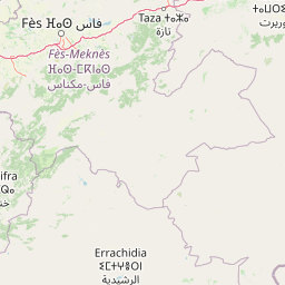
Map view of Haut Atlas Oriental National Park

Use this park location map to pinpoint Haut Atlas Oriental National Park in Morocco, understand its exact geographic position, and read its mapped placement within the surrounding landscape more clearly.

Pigeon | © OpenStreetMap contributors
Park atlas

Map the diverse High Atlas mountain terrain and compare adjacent conservation landscapes across Morocco

Explore Nearby National Parks and Protected Areas Near Haut Atlas Oriental National Park
Discover other national parks and protected areas near Haut Atlas Oriental National Park, exploring a curated selection across Morocco's High Atlas mountain range. Compare diverse protected landscapes, from alpine wetlands to cedar forests, and map the regional spread of conservation efforts beyond a single park entity.
National parkMorocco

Khenifra National Park: National Park Atlas and Mapped Protected Landscape

Geographic context and protected area mapping for Morocco.

Explore the atlas perspective of Khenifra National Park, a designated national park in Morocco. This page provides detailed geographic context, focusing on its mapped protected landscape and its role within the country's network of conservation areas. Understand the park's terrain and regional setting through structured geographic data.

Area
842 km²
Established
2008
Relief
Mountain
Climate
Mediterranean
National parkMorocco

Ifrane National Park: Protected Landscape and Geographic Context in Morocco

National park boundaries and mapped terrain.

Investigate Ifrane National Park, a designated national park in Morocco, and its contribution to the country's protected lands. This profile details its geographic location, providing context for its mapped presence and the natural landscapes it encompasses. Delve into the atlas-relevant features that define this protected area, focusing on its geographic identity within Morocco's natural heritage.

Area
500 km²
Established
2004
IUCN
II
Relief
Mountain
National parkTaza Province

Tazekka National Park: Protected Landscape and Geographic Context in Taza Province

Discover its national park status and mapped terrain.

Tazekka National Park serves as a vital protected area within the geographic framework of Taza Province, Morocco. This national park offers a distinct landscape for exploration, allowing users to investigate its mapped boundaries and regional natural features. Understand the park's role in the local geography and its contribution to Morocco's atlas of protected lands. Its specific terrain and setting make it a key point for structured geographic discovery.

Area
120 km²
Established
1950
IUCN
II
Relief
Mountain
National parkMorocco

Toubkal National Park: Morocco's Key Protected National Park for Geographic Exploration

Mapped boundaries and regional landscape context within Morocco.

Toubkal National Park stands as a significant protected area within Morocco, offering a lens through which to explore its diverse natural geography and protected landscapes. This national park designation signifies its importance for understanding the country's conservation efforts and its mapped territorial integrity. Users can discover the park's unique geographic attributes and its role within the larger atlas of Moroccan protected lands, providing foundational context for further geographic discovery.

Area
380 km²
Established
1942
IUCN
II
Relief
Mountain
Watercolor illustration showing a landscape with green hills, vegetation, and distant mountains
National parkMorocco

Al Hoceima National Park: Morocco's Coastal and Marine Protected Wilderness

Explore dramatic cliffs, kelp forests, and marine biodiversity.

Al Hoceima National Park represents a significant protected coastal and marine area in northern Morocco, distinguished by its rugged 50-kilometer Mediterranean coastline featuring spectacular limestone cliffs. This national park offers an atlas-style view of a landscape transitioning from the Ibaqouyen Rif mountains to the sea, harboring rich marine biodiversity including significant osprey colonies and dolphin habitats. Discover the mapped extent of this wild protected territory and its unique ecological features.

Area
480 km²
Established
2004
IUCN
II
Relief
Mountain
National parkMorocco

Souss-Massa National Park: Moroccan Coastal Protected Landscape and Geographic Map

Explore vital protected areas and mapped natural terrain on the Atlantic coast.

Souss-Massa National Park is a critical national park situated along the Atlantic coast of Morocco. This protected landscape offers a unique atlas-style view of its diverse geography, including vital wetlands, sand dunes, and coastal steppe. Delve into the mapped boundaries and understand the park's ecological significance within Morocco's regional landscape context.

Area
338 km²
Established
1991
IUCN
II
Relief
Lowland
National parkTlemcen Province

Tlemcen National Park National Park: Mapped Boundaries and Regional Geographic Context

Discover protected landscapes within Tlemcen Province.

Delve into Tlemcen National Park, an important protected landscape situated within Tlemcen Province. This detail page offers a focused exploration of its specific geographic identity, mapped park boundaries, and the natural terrain it encompasses, providing essential context for understanding its role in regional geography and protected land exploration within Algeria.

Area
82.25 km²
Established
1993
IUCN
II
Relief
Mixed relief
National park

Sierra de las Nieves National Park: Ancient Fir Forests and Karst Geography in Andalusia

Mapped protected landscape and unique geologic features

Sierra de las Nieves National Park stands as a remarkable protected area in Andalusia, Spain, celebrated for its world-leading Spanish fir forests and intricate karst topography. This national park showcases significant geological diversity, from towering limestone formations and deep caves to the striking red peridotite mountains of Sierra Bermeja. Its elevation, reaching Pico Torrecilla at 1,919 meters, offers a unique alpine landscape context within southern Europe, mapped for detailed geographic discovery and protected area exploration.

Area
939.3 km²
Established
1989
IUCN
II
Visitors
100K annual

Common questions about visiting, size, designation, and location context for Haut Atlas Oriental National Park

Haut Atlas Oriental National Park FAQs for park facts, access, geography, and protected area context
Find quick answers about Haut Atlas Oriental National Park, including protected-area facts, park geography, trail and visitor context, and how the park fits into its surrounding country and regional landscape.
MoriAtlas Explorer

Continue Your Protected Areas Search Across the Global Atlas

Deepen your exploration by continuing the structured search for national parks and protected areas worldwide. Utilize the comprehensive filtering capabilities to compare different conservation landscapes and refine your understanding of global park geography. Discover more about the distribution and characteristics of protected natural areas.

Global natural geography