Mori Atlas logo
National parkKhenifra National Park

Mapping the protected landscape and geographic context of Khenifra National Park, Morocco.

Khenifra National Park: National Park Protected Area Geography and Atlas Exploration

Discover Khenifra National Park, a significant national park within Morocco's protected lands. This page offers detailed geographic context and atlas-driven insights into the park's protected boundaries and its place within the regional landscape. Understand its unique setting and explore its mapped terrain through MoriAtlas.

National ParkMoroccoMiddle Atlas MountainsMediterranean ForestAtlas CedarMountain Wilderness

Khenifra National Park

National park

Park overview

Structured park overview, official facts, and landscape profile for Khenifra National Park

Khenifra National Park park facts, protected area profile, and essential visitor context
Review the core facts for Khenifra National Park, including designation, size, terrain, visitor scale, habitats, and operating context in one park-focused overview.

About Khenifra National Park

Khenifra National Park occupies a mountainous landscape in central Morocco that forms part of the broader Middle Atlas mountain system, one of three major Atlas ranges traversing the country from southwest to northeast. The park was officially established in 2008, making it one of Morocco's younger national parks, though the region had previous protected status as a hunting reserve. The park's creation reflected Morocco's growing commitment to conserving its Mediterranean mountain ecosystems and the unique species they support. The protected area stretches across elevations ranging from around 1,500 meters to over 2,500 meters above sea level, encompassing diverse habitat types from forested slopes to alpine zones. The two notable lakes within the park, Aguelmame Aziza and Aguelmame Sidi Ali, are important ecological features that support aquatic life and attract bird species throughout the year. The park is situated in a region where human communities have historically practiced transhumant pastoralism, and the relationship between local communities and the mountain landscape continues to influence conservation dynamics in the area.

Quick facts and research context for Khenifra National Park

Khenifra National Park is located in central Morocco within the Middle Atlas Mountains, approximately 842 square kilometers in size, established in 2008. The park protects a diverse landscape of cedar and oak forests, alpine meadows, and two significant high-altitude lakes. Notable wildlife includes the endangered Barbary macaque, Barbary stag, Barbary sheep, and Cuvier's gazelle, along with bird species such as the Algerian nuthatch, golden eagle, and osprey. The area is part of a broader regional ecosystem that supports Morocco's remaining wilderness populations of several iconic North African species.

Park context

Deeper park guide and search-rich context for Khenifra National Park

Khenifra National Park history, landscape, wildlife, and travel context
Explore Khenifra National Park through its history, landscape character, ecosystems, wildlife, conservation priorities, cultural context, and seasonal travel timing in a structured park guide built for atlas discovery and search intent.

Why Khenifra National Park stands out

Khenifra National Park is best known for its population of Barbary macaques, one of the few surviving wild populations of this primate species outside captivity, and for protecting one of the last strongholds of the Barbary stag in North Africa. The park's high-altitude cedar and juniper forests represent a vanishing ecosystem type in the Mediterranean region, and its twin lake system of Aguelmame Aziza and Aguelmame Sidi Ali provides critical habitat for migratory waterfowl and rare bird species. The park also encompasses some of the most scenic mountain terrain in the Middle Atlas, with dramatic elevations and relatively intact natural landscapes.

Khenifra National Park history and protected-area timeline

Khenifra National Park was officially established in 2008 as part of Morocco's expanding network of protected areas. Prior to national park designation, the area functioned as a hunting reserve, providing a degree of regulatory protection for wildlife populations. The elevation to full national park status reflected both the ecological significance of the Middle Atlas region and growing recognition of the need to protect Morocco's diminishing wilderness areas. The park's establishment came during a period of increased environmental awareness in Morocco and coincided with broader efforts to develop sustainable tourism and conservation strategies for the country's mountainous regions. The Middle Atlas region has long held strategic and economic importance for Morocco, with its forests and watersheds supporting agricultural communities throughout central Morocco.

Khenifra National Park landscape and geographic character

The landscape of Khenifra National Park is characterized by mountainous terrain typical of the Middle Atlas range, featuring steep-sided valleys, elevated plateaus, and rounded mountain summits. The park encompasses significant forest coverage, with Atlas cedar and juniper trees dominating the higher elevations, while oak species populate the lower slopes. The terrain includes areas of exposed rock and cliff formations interspersed with forested zones, creating a varied topographic character. The two prominent lakes within the park, Aguelmame Aziza and Aguelmame Sidi Ali, sit at high altitude and provide striking aquatic features within the mountain landscape. The overall character of the landscape is one of relative wilderness, with extensive areas of natural vegetation and limited permanent human settlement within the park boundaries themselves.

Khenifra National Park ecosystems, habitats, and plant life

The ecological character of Khenifra National Park is defined by its Mediterranean mountain environment, which supports a mix of forest, scrub, and wetland habitats. The Atlas cedar forests represent one of the most significant vegetation types, forming extensive woodlands on north-facing slopes and higher elevations. These forests provide critical habitat for many of the park's notable species and contribute to watershed protection for the broader region. The park's lake systems create important wetland habitats that support diverse birdlife and provide water resources for both wildlife and local communities. The combination of forest, alpine, and aquatic habitats within a relatively compact protected area makes this region ecologically significant at both national and international scales, supporting species assemblages found nowhere else in Morocco.

Khenifra National Park wildlife and species highlights

Khenifra National Park supports a remarkable diversity of wildlife, with several species of significant conservation concern calling the area home. The Barbary macaque, a primate species with limited wild populations, persists in the park's forests, representing one of the last remaining wild populations in North Africa. The Barbary stag, also known as the Atlas deer, is another flagship species of the region, and the park provides important habitat for this deer species. Additional notable mammals include Barbary sheep, Cuvier's gazelle, and Barbary wild boar. The birdlife is equally noteworthy, with the Algerian nuthatch representing a species of particular interest, while birds of prey including the golden eagle and osprey soar above the mountain terrain. Waterfowl congregate at the park's lakes, with species such as the ruddy shelduck and red-knobbed coot present in significant numbers.

Khenifra National Park conservation status and protection priorities

Khenifra National Park represents an important conservation asset for Morocco, protecting a mountainous ecosystem that faces multiple pressures including habitat degradation, overgrazing, and climate change. The park provides legal protection for populations of several threatened species and preserves genetic diversity in a region where natural habitats have diminished considerably. The designation as a national park brings regulatory frameworks for managing human activities within the protected area and provides resources for conservation management. The park's lakes are particularly sensitive ecological features that benefit from protected status, as they serve as crucial water sources and wildlife habitat in a region where water availability is increasingly stressed. Conservation of the cedar forests and their associated wildlife represents a long-term priority for the protected area.

Khenifra National Park cultural meaning and human context

The Middle Atlas region has been inhabited for centuries by Berber communities whose traditional livelihoods have been closely tied to the mountain environment. Pastoral transhumance, moving flocks between seasonal grazing areas, has shaped both the cultural landscape and the ecological dynamics of the region. The town of Khenifra, located near the park's western boundary, has historically served as a regional center for the surrounding mountain communities. While the park itself maintains strict protection, the surrounding landscape includes areas where traditional land use practices continue, creating a buffer zone context where conservation and community livelihoods intersect.

Top sights and standout views in Khenifra National Park

The mountain landscapes of Khenifra National Park offer some of the most impressive wilderness scenery in central Morocco, with extensive cedar forests, dramatic lake views, and opportunities to observe wildlife including the rare Barbary macaque and Barbary stag. The twin lakes of Aguelmame provide scenic focal points for visitors exploring the park, while the forest trails offer possibilities for wildlife viewing and landscape appreciation. The park represents one of the best remaining examples of Mediterranean mountain ecosystems in North Africa and provides research and educational opportunities related to forest ecology and mountain conservation.

Best time to visit Khenifra National Park

The most favorable time to visit Khenifra National Park coincides with the spring and early summer months when weather conditions are mild and the park's landscapes are at their most vibrant. Spring brings renewed vegetation and increased wildlife activity, while the lakes host migratory bird species during this period. Summer months can be pleasant at higher elevations though temperatures may rise significantly in the valleys. Autumn offers another good visiting period as the landscape takes on autumn colors and weather remains comfortable for exploration. Winter conditions can be harsh at altitude, with snow potentially affecting access to some areas of the park.
Park location guide

Geography guide, regional context, and park location map for Khenifra National Park

Khenifra National Park park geography, regions, and map view in Morocco
Understand where Khenifra National Park sits in Morocco through a broader geographic reading of the surrounding landscape, nearby location context, and its mapped position within the national park landscape.

How Khenifra National Park fits into Morocco

Morocco is a North African country bordering the Mediterranean Sea to the north and Atlantic Ocean to the west. It borders Algeria to the east and the disputed Western Sahara territory to the south. The country operates as a parliamentary constitutional monarchy under King Mohammed VI, with Arabic and Tamazight as official languages. Morocco has a population of approximately 37 million and covers an area of about 446,550 km².

Wider geography shaping Khenifra National Park in Morocco

Morocco occupies the northwestern corner of Africa, bordering the Mediterranean Sea to the north and Atlantic Ocean to the west. The country shares borders with Algeria to the east and the disputed Western Sahara territory to the south. The terrain is diverse, featuring the Atlas Mountains in the central and southern regions, Rif Mountains in the north, and plains along the coastal areas. The country also claims Spanish exclaves of Ceuta and Melilla.

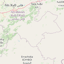
Map view of Khenifra National Park

Use this park location map to pinpoint Khenifra National Park in Morocco, understand its exact geographic position, and read its mapped placement within the surrounding landscape more clearly.

Pigeon | © OpenStreetMap contributors

Location context for Khenifra National Park

Middle Atlas Mountains
Park atlas

Compare protected landscapes and mountain wilderness areas across the Middle Atlas region, extending beyond Khenifra National Park's boundaries.

Explore Other National Parks and Protected Areas Near Khenifra National Park in Morocco
Browse national parks and protected areas near Khenifra National Park, exploring the diverse mountain wilderness and Mediterranean forests of Morocco's Middle Atlas region. Compare their unique features, conservation efforts, and geographic spread to gain a comprehensive understanding of regional protected landscapes.
National parkMorocco

Ifrane National Park: Protected Landscape and Geographic Context in Morocco

National park boundaries and mapped terrain.

Investigate Ifrane National Park, a designated national park in Morocco, and its contribution to the country's protected lands. This profile details its geographic location, providing context for its mapped presence and the natural landscapes it encompasses. Delve into the atlas-relevant features that define this protected area, focusing on its geographic identity within Morocco's natural heritage.

Area
500 km²
Established
2004
IUCN
II
Relief
Mountain
National parkMorocco

Haut Atlas Oriental National Park: National Park Mapping and Protected Landscape Identity

Explore its mapped geography and regional atlas context.

Delve into the specifics of Haut Atlas Oriental National Park, a designated national park in Morocco. This page serves as a detailed atlas entry, focusing on the park's protected landscape characteristics, its defined geographic boundaries, and its significance within the national park system. Understand the terrain and regional context that shape this important natural area for focused discovery.

Area
490 km²
IUCN
II
Relief
Mountain
Climate
Alpine
National parkTaza Province

Tazekka National Park: Protected Landscape and Geographic Context in Taza Province

Discover its national park status and mapped terrain.

Tazekka National Park serves as a vital protected area within the geographic framework of Taza Province, Morocco. This national park offers a distinct landscape for exploration, allowing users to investigate its mapped boundaries and regional natural features. Understand the park's role in the local geography and its contribution to Morocco's atlas of protected lands. Its specific terrain and setting make it a key point for structured geographic discovery.

Area
120 km²
Established
1950
IUCN
II
Relief
Mountain
Watercolor illustration showing a landscape with green hills, vegetation, and distant mountains
National parkMorocco

Al Hoceima National Park: Morocco's Coastal and Marine Protected Wilderness

Explore dramatic cliffs, kelp forests, and marine biodiversity.

Al Hoceima National Park represents a significant protected coastal and marine area in northern Morocco, distinguished by its rugged 50-kilometer Mediterranean coastline featuring spectacular limestone cliffs. This national park offers an atlas-style view of a landscape transitioning from the Ibaqouyen Rif mountains to the sea, harboring rich marine biodiversity including significant osprey colonies and dolphin habitats. Discover the mapped extent of this wild protected territory and its unique ecological features.

Area
480 km²
Established
2004
IUCN
II
Relief
Mountain
National parkMorocco

Toubkal National Park: Morocco's Key Protected National Park for Geographic Exploration

Mapped boundaries and regional landscape context within Morocco.

Toubkal National Park stands as a significant protected area within Morocco, offering a lens through which to explore its diverse natural geography and protected landscapes. This national park designation signifies its importance for understanding the country's conservation efforts and its mapped territorial integrity. Users can discover the park's unique geographic attributes and its role within the larger atlas of Moroccan protected lands, providing foundational context for further geographic discovery.

Area
380 km²
Established
1942
IUCN
II
Relief
Mountain
National park

Sierra de las Nieves National Park: Ancient Fir Forests and Karst Geography in Andalusia

Mapped protected landscape and unique geologic features

Sierra de las Nieves National Park stands as a remarkable protected area in Andalusia, Spain, celebrated for its world-leading Spanish fir forests and intricate karst topography. This national park showcases significant geological diversity, from towering limestone formations and deep caves to the striking red peridotite mountains of Sierra Bermeja. Its elevation, reaching Pico Torrecilla at 1,919 meters, offers a unique alpine landscape context within southern Europe, mapped for detailed geographic discovery and protected area exploration.

Area
939.3 km²
Established
1989
IUCN
II
Visitors
100K annual
National parkTlemcen Province

Tlemcen National Park National Park: Mapped Boundaries and Regional Geographic Context

Discover protected landscapes within Tlemcen Province.

Delve into Tlemcen National Park, an important protected landscape situated within Tlemcen Province. This detail page offers a focused exploration of its specific geographic identity, mapped park boundaries, and the natural terrain it encompasses, providing essential context for understanding its role in regional geography and protected land exploration within Algeria.

Area
82.25 km²
Established
1993
IUCN
II
Relief
Mixed relief
Watercolor illustration of a river flowing through wetlands with trees and distant hills
National parkHuelva

Doñana National Park National Park: Mapped Geography and Protected Landscape Context

Explore Huelva's key protected area and its regional geographic setting.

Delve into the structured geographic data and mapped boundaries of Doñana National Park. This entry highlights its identity as a national park within the Huelva region, providing essential context for understanding its protected landscape. MoriAtlas offers this detail to facilitate a clear, atlas-driven exploration of its natural terrain and its place in the broader geographic framework of Spain.

Area
543 km²
Established
1969
IUCN
II
Visitors
376.3K annual

Common questions about visiting, size, designation, and location context for Khenifra National Park

Khenifra National Park FAQs for park facts, access, geography, and protected area context
Find quick answers about Khenifra National Park, including protected-area facts, park geography, trail and visitor context, and how the park fits into its surrounding country and regional landscape.
MoriAtlas Explorer

Continue Your Protected Areas Search Across the Global Atlas

Deepen your exploration by continuing the structured search for national parks and protected areas worldwide. Utilize the comprehensive filtering capabilities to compare different conservation landscapes and refine your understanding of global park geography. Discover more about the distribution and characteristics of protected natural areas.

Global natural geography