Mori Atlas logo
National parkTlemcen National Park

Discover the mapped boundaries and natural terrain within Tlemcen Province's national park.

Tlemcen National Park: Algeria's Protected Landscape and Regional Geography

Tlemcen National Park represents a key protected landscape within Algeria, situated in the Tlemcen Province. This entry provides detailed insight into its protected-area identity, mapped geographic scope, and the natural terrain that defines its protected boundaries. Users can leverage this information for comprehensive atlas exploration and understanding the park's regional geographic context.

Mediterranean forestMountain landscapesWaterfallsArchaeological sitesBirdwatchingCultural heritage

Tlemcen National Park

National park

Park overview

Structured park overview, official facts, and landscape profile for Tlemcen National Park

Tlemcen National Park park facts, protected area profile, and essential visitor context
Review the core facts for Tlemcen National Park, including designation, size, terrain, visitor scale, habitats, and operating context in one park-focused overview.

About Tlemcen National Park

Tlemcen National Park occupies a mountainous region in northwestern Algeria where the Tell Atlas system creates a landscape of forested ridges, steep valleys, and dramatic rock faces. The park's establishment in 1993 reflected Algeria's growing recognition of the need to protect its Mediterranean mountain ecosystems, which support distinctive flora and fauna adapted to this climate zone. The protected area serves as a green lung for the Tlemcen region, preserving forest cover that has historical and ecological significance while providing habitat for diverse wildlife species. The park's location relative to the historic city of Tlemcen creates a meaningful connection between urban heritage and natural preservation, with the park itself containing elements of that heritage within its boundaries.

Quick facts and research context for Tlemcen National Park

Tlemcen National Park covers approximately 82 square kilometers in the Tell Atlas mountain region of northwestern Algeria. The protected area incorporates several distinct ecological zones including the forests of Ifri, Zariffet, and Aïn Fezza, as well as the scenic El Awrit waterfalls and cliff formations. The park lies in Tlemcen Province, with the city of Tlemcen serving as the nearest urban center. Established in 1993, the park represents Algeria's commitment to preserving its Mediterranean mountain ecosystems and associated cultural heritage.

Park context

Deeper park guide and search-rich context for Tlemcen National Park

Tlemcen National Park history, landscape, wildlife, and travel context
Explore Tlemcen National Park through its history, landscape character, ecosystems, wildlife, conservation priorities, cultural context, and seasonal travel timing in a structured park guide built for atlas discovery and search intent.

Why Tlemcen National Park stands out

Tlemcen National Park is distinctive for its unusual combination of natural landscapes and archaeological significance. The park protects Mediterranean forest ecosystems in a mountainous setting, featuring cascading waterfalls and dramatic cliff faces at El Awrit. Equally important is its cultural heritage dimension, as the park contains the ruins of Mansoura, the ancient city whose remains became the foundation for modern Tlemcen, as well as the Mosque of Sidi Boumediene, dedicated to the patron saint of Tlemcen. This blend of scenic natural beauty with significant archaeological and religious sites makes the park uniquely positioned among Algeria's protected areas.

Tlemcen National Park history and protected-area timeline

Tlemcen National Park was established in 1993 as part of Algeria's national park system, representing a relatively recent addition to the country's protected area network. The park's creation reflected growing environmental awareness in Algeria during the late 20th century and the desire to preserve unique landscapes that combined natural and cultural significance. The region surrounding Tlemcen has been inhabited for centuries, and the park preserves evidence of this long human presence, including the ruins of Mansoura, a medieval city founded in the 11th century that eventually became absorbed into the modern city of Tlemcen. The Mosque of Sidi Boumediene, also located within the park boundaries, commemorates the patron saint of Tlemcen and represents the spiritual heritage of the region.

Tlemcen National Park landscape and geographic character

The physical landscape of Tlemcen National Park features the rugged terrain characteristic of Algeria's Tell Atlas mountain region. The park incorporates three principal forest areas: Ifri, Zariffet, and Aïn Fezza, which grow on the mountain slopes and valleys within the protected zone. The El Awrit area within the park contains dramatic waterfalls and sheer cliffs that create scenic visual interest and support specialized habitats. The terrain varies from forested slopes to rocky outcrops, with elevation changes contributing to ecological diversity within the park boundaries. This combination of forest, water, and cliff environments creates a varied landscape that supports multiple habitat types.

Tlemcen National Park ecosystems, habitats, and plant life

The park's Mediterranean forest ecosystems host a notable diversity of plant and animal life. The forests of Ifri, Zariffet, and Aïn Fezza represent Mediterranean woodland types adapted to the climate of northwestern Algeria, with characteristic species that thrive in this environment. These forest areas provide habitat for numerous animal species and contribute to the ecological connectivity of the wider region. The presence of permanent water sources from waterfalls and streams within the park adds to its ecological value, supporting species that depend on aquatic habitats. The varied topography and multiple habitat types within the relatively compact 82 square kilometer area create conditions for biological diversity.

Tlemcen National Park wildlife and species highlights

Tlemcen National Park is home to more than 141 species of animals, demonstrating notable biodiversity within its boundaries. The park supports approximately 100 species of birds, reflecting the importance of this Mediterranean forest habitat for avian diversity. Mammal species number around 16 within the park, while reptiles are represented by 18 species and amphibians by 7 species. This mix of wildlife reflects the diverse habitats found within the protected area, from forest floors to cliff faces to water environments. The birdlife is particularly significant, with the forest and cliff environments providing nesting sites, feeding grounds, and migration corridors for numerous species.

Tlemcen National Park conservation status and protection priorities

The establishment of Tlemcen National Park in 1993 created formal protection for a mountain forest ecosystem that might otherwise have faced degradation from human activity. The park's designation as an IUCN Category II protected area reflects its primary purpose of conserving natural ecosystems while allowing for sustainable use where appropriate. Beyond its natural values, the park also protects cultural heritage sites, demonstrating an integrated approach to landscape conservation that recognizes both ecological and historical significance. The protection of watersheds and forest cover in this mountainous region has implications for soil conservation and water resource management in the surrounding Tlemcen Province.

Tlemcen National Park cultural meaning and human context

Tlemcen National Park contains significant cultural heritage that reflects the long history of human settlement in this region of northwestern Algeria. The ruins of Mansoura, located within the park boundaries, represent the remains of a medieval city founded by the Almohads in the 11th century. This ancient settlement eventually became the foundation upon which the modern city of Tlemcen was built. The Mosque of Sidi Abu Madyan, also known as the Mosque of Sidi Boumediene, honors the patron saint of Tlemcen and represents the spiritual heritage associated with this landscape. The presence of these archaeological and religious sites within a national park creates a unique situation where natural and cultural preservation intersect.

Top sights and standout views in Tlemcen National Park

The most distinctive highlights of Tlemcen National Park include the El Awrit waterfalls and cliffs, which create scenic drama in the mountain forest setting. The ancient ruins of Mansoura offer a remarkable cultural dimension rarely found within national parks, providing tangible evidence of medieval Algerian urban history. The three forest areas of Ifri, Zariffet, and Aïn Fezza represent well-preserved Mediterranean woodland that forms the ecological backbone of the park. The combination of natural beauty with archaeological and religious significance makes this park unusually rich in both landscape and heritage values.

Best time to visit Tlemcen National Park

The best time to visit Tlemcen National Park is during the spring and autumn months when temperatures are moderate and the landscape displays seasonal variety. Spring brings flowering of forest vegetation and active wildlife activity, while autumn offers pleasant conditions and potential for seeing migrating bird species. The summer months can bring high temperatures typical of the Mediterranean climate, while winters may see cooler conditions and reduced visitor facilities. The park's mountain setting influences local climate patterns, and visitors seeking comfortable exploration should plan for the more temperate seasons.
Park location guide

Geography guide, regional context, and park location map for Tlemcen National Park

Tlemcen National Park park geography, regions, and map view in Algeria
Understand where Tlemcen National Park sits in Algeria through a broader geographic reading of the surrounding landscape, nearby location context, and its mapped position within the national park landscape.

How Tlemcen National Park fits into Algeria

Algeria is a North African country spanning over 2.38 million km², making it the largest country in Africa. It borders the Mediterranean Sea to the north and shares land borders with seven countries. The population exceeds 47 million, with most concentrated in the northern coastal region.

Wider geography shaping Tlemcen National Park in Algeria

Algeria occupies the central portion of the Maghreb region in North Africa. It is bordered by Tunisia and Libya to the northeast, Niger to the southeast, Mali, Mauritania, and Western Sahara to the southwest, and Morocco to the west. The Mediterranean Sea forms its northern border. The terrain consists of the Tell Atlas mountain range and coastal plains in the north, transitioning to the Sahara desert in the south.

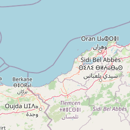
Map view of Tlemcen National Park

Use this park location map to pinpoint Tlemcen National Park in Algeria, understand its exact geographic position, and read its mapped placement within the surrounding landscape more clearly.

Pigeon | © OpenStreetMap contributors

Location context for Tlemcen National Park

Tlemcen Province
Park atlas

Compare the Diverse Mediterranean Forests and Archaeological Sites Across Algeria's Protected Landscapes

Explore Other National Parks and Protected Areas Near Tlemcen National Park
Continue your exploration from Tlemcen National Park by browsing other protected areas throughout northwestern Algeria and its surrounding regions. Map and compare diverse landscapes, including mountainous terrain, coastal zones, and additional heritage sites, to understand the broader conservation geography.
Watercolor illustration showing a landscape with green hills, vegetation, and distant mountains
National parkMorocco

Al Hoceima National Park: Morocco's Coastal and Marine Protected Wilderness

Explore dramatic cliffs, kelp forests, and marine biodiversity.

Al Hoceima National Park represents a significant protected coastal and marine area in northern Morocco, distinguished by its rugged 50-kilometer Mediterranean coastline featuring spectacular limestone cliffs. This national park offers an atlas-style view of a landscape transitioning from the Ibaqouyen Rif mountains to the sea, harboring rich marine biodiversity including significant osprey colonies and dolphin habitats. Discover the mapped extent of this wild protected territory and its unique ecological features.

Area
480 km²
Established
2004
IUCN
II
Relief
Mountain
National parkTaza Province

Tazekka National Park: Protected Landscape and Geographic Context in Taza Province

Discover its national park status and mapped terrain.

Tazekka National Park serves as a vital protected area within the geographic framework of Taza Province, Morocco. This national park offers a distinct landscape for exploration, allowing users to investigate its mapped boundaries and regional natural features. Understand the park's role in the local geography and its contribution to Morocco's atlas of protected lands. Its specific terrain and setting make it a key point for structured geographic discovery.

Area
120 km²
Established
1950
IUCN
II
Relief
Mountain
Watercolor painting showing mountains, trees, and fields
National parkAndalusia

Sierra Nevada National Park: Protected Alpine Terrain and Geographic Context in Andalusia

Explore Spain's highest mountain range mapped across Andalusia's atlas.

Sierra Nevada National Park offers a profound exploration of Spain's highest alpine environments and a significant entry in the regional geography atlas. This protected area showcases classic glacial landforms, U-shaped valleys, and numerous high-mountain lakes, alongside a remarkable abundance of endemic plant species thriving in its unique microclimates. Understanding its mapped boundaries reveals a landscape vital for both biodiversity and watershed, situated prominently within the broader geographic context of Andalusia.

Area
858.83 km²
Established
1999
IUCN
II
Relief
Mountain
National parkMorocco

Ifrane National Park: Protected Landscape and Geographic Context in Morocco

National park boundaries and mapped terrain.

Investigate Ifrane National Park, a designated national park in Morocco, and its contribution to the country's protected lands. This profile details its geographic location, providing context for its mapped presence and the natural landscapes it encompasses. Delve into the atlas-relevant features that define this protected area, focusing on its geographic identity within Morocco's natural heritage.

Area
500 km²
Established
2004
IUCN
II
Relief
Mountain
National park

Sierra de las Nieves National Park: Ancient Fir Forests and Karst Geography in Andalusia

Mapped protected landscape and unique geologic features

Sierra de las Nieves National Park stands as a remarkable protected area in Andalusia, Spain, celebrated for its world-leading Spanish fir forests and intricate karst topography. This national park showcases significant geological diversity, from towering limestone formations and deep caves to the striking red peridotite mountains of Sierra Bermeja. Its elevation, reaching Pico Torrecilla at 1,919 meters, offers a unique alpine landscape context within southern Europe, mapped for detailed geographic discovery and protected area exploration.

Area
939.3 km²
Established
1989
IUCN
II
Visitors
100K annual
National parkMorocco

Khenifra National Park: National Park Atlas and Mapped Protected Landscape

Geographic context and protected area mapping for Morocco.

Explore the atlas perspective of Khenifra National Park, a designated national park in Morocco. This page provides detailed geographic context, focusing on its mapped protected landscape and its role within the country's network of conservation areas. Understand the park's terrain and regional setting through structured geographic data.

Area
842 km²
Established
2008
Relief
Mountain
Climate
Mediterranean
National parkMorocco

Haut Atlas Oriental National Park: National Park Mapping and Protected Landscape Identity

Explore its mapped geography and regional atlas context.

Delve into the specifics of Haut Atlas Oriental National Park, a designated national park in Morocco. This page serves as a detailed atlas entry, focusing on the park's protected landscape characteristics, its defined geographic boundaries, and its significance within the national park system. Understand the terrain and regional context that shape this important natural area for focused discovery.

Area
490 km²
IUCN
II
Relief
Mountain
Climate
Alpine
Watercolor illustration showing a wetland landscape with grasses, a body of water, and distant hills
National park

Tablas de Daimiel National Park: Spain's Inland Wetland National Park and Protected Area

Explore mapped boundaries and regional geographic context.

Tablas de Daimiel National Park represents one of the last remaining examples of floodplain wetland systems in Spain's interior. Located in Castilla-La Mancha, this protected area showcases a unique confluence of fresh and brackish waters, supporting a rich mosaic of emergent vegetation and serving as a critical habitat for migratory birds. Use MoriAtlas to explore its precise geographic setting, mapped terrain, and its role as a vital conservation landscape within the Iberian Peninsula.

Area
30.3 km²
Established
1973
IUCN
II
Relief
Lowland

Common questions about visiting, size, designation, and location context for Tlemcen National Park

Tlemcen National Park FAQs for park facts, access, geography, and protected area context
Find quick answers about Tlemcen National Park, including protected-area facts, park geography, trail and visitor context, and how the park fits into its surrounding country and regional landscape.
MoriAtlas Explorer

Continue Your Protected Areas Search Across the Global Atlas

Deepen your exploration by continuing the structured search for national parks and protected areas worldwide. Utilize the comprehensive filtering capabilities to compare different conservation landscapes and refine your understanding of global park geography. Discover more about the distribution and characteristics of protected natural areas.

Global natural geography