Mori Atlas logo
National parkTazekka National Park

Discover the mapped boundaries and natural terrain of this Moroccan national park.

Tazekka National Park: Protected Landscape and Regional Geography in Taza Province

Tazekka National Park represents a significant protected area within the geography of Taza Province, Morocco. As a national park, its landscape offers a unique context for understanding regional natural features and mapped terrain. Explore the park's protected boundaries and geographic setting to gain insights into the area's natural context. This page provides detailed information for atlas-based discovery and appreciation of Morocco's protected lands.

National ParkMoroccoMiddle AtlasAtlas CedarCave SystemKarst

Tazekka National Park

National park

Park overview

Structured park overview, official facts, and landscape profile for Tazekka National Park

Tazekka National Park park facts, protected area profile, and essential visitor context
Review the core facts for Tazekka National Park, including designation, size, terrain, visitor scale, habitats, and operating context in one park-focused overview.

About Tazekka National Park

Tazekka National Park occupies a distinctive position in Morocco's Middle Atlas Mountains, protecting a landscape of considerable ecological and geological value near the city of Taza. The park's focal feature is Jbel Tazekka, a mountain peak that rises sharply from the surrounding terrain to an elevation of 1,980 meters. This peak supports one of the most significant remaining populations of Atlas cedar (Cedrus atlantica) in Morocco, an evergreen conifer that once dominated much of the Atlas mountain forests but now persists in scattered remnants due to centuries of logging and habitat conversion. The original protected area established in 1950 covered just 6.8 square kilometers around the cedar grove, recognizing the urgent need to preserve this isolated and biologically significant forest. The 1989 expansion added nearly 110 square kilometers of additional terrain, incorporating cork oak and holm oak forests, deep canyons, cascades, and the rural agricultural landscapes that surround the core protected zone. The park's terrain is rugged and varied, with limestone ridges, steep valleys, and the remarkable karst depression known as the Daya Chiker polje that borders the northern sector. This geological complexity supports diverse habitats within a relatively compact area, making Tazekka an important refuge for species adapted to mountain forest and rocky terrain.

Quick facts and research context for Tazekka National Park

Tazekka National Park occupies roughly 120 square kilometers in Morocco's Middle Atlas Mountains near Taza. The park was created in 1950 to protect the Atlas cedar grove on Jbel Tazekka peak and expanded in 1989 to include cork oak and holm oak forests, canyons, and cave systems. The park is designated as an Important Bird Area by BirdLife International due to its populations of Barbary partridge, Levaillant's woodpecker, and several warbler species. The Friouato Caves system within the park reaches 272 meters in depth and contains an underground river approximately 3.8 kilometers long.

Park context

Deeper park guide and search-rich context for Tazekka National Park

Tazekka National Park history, landscape, wildlife, and travel context
Explore Tazekka National Park through its history, landscape character, ecosystems, wildlife, conservation priorities, cultural context, and seasonal travel timing in a structured park guide built for atlas discovery and search intent.

Why Tazekka National Park stands out

Tazekka National Park is best known for its Atlas cedar forests that clothe the slopes of Jbel Tazekka, representing an isolated population of this iconic conifer at the northern edge of its range. The park also contains the extensive Friouato Caves, a karst system with stalactites, stalagmites, and an underground river that ranks among Morocco's most impressive cave formations. The combination of mountain forest, dramatic limestone cliffs, and the reintroduction of the extinct Barbary stag distinguishes this park within Morocco's protected area network.

Tazekka National Park history and protected-area timeline

Tazekka National Park was established in 1950 with an initial area of 6.8 square kilometers, created specifically to protect the natural resources of Jbel Tazekka and its distinctive grove of Atlas cedars. At the time of establishment, the cedar forest represented one of the few remaining significant stands of this species in the Middle Atlas region, as extensive logging throughout the 19th and 20th centuries had eliminated or severely degraded most other cedar forests. The original park designation recognized both the ecological importance of the cedar population and the need to preserve the watershed functions of this mountainous terrain. In 1989, the park underwent a substantial expansion that increased its area to approximately 120 square kilometers, incorporating ecologically important zones that had previously lacked formal protection. This expansion brought cork oak and holm oak forests, canyon systems, caves, and rural landscapes under the protected area framework. The expansion reflected growing recognition of the need to protect complete ecological communities rather than isolated forest remnants, and to maintain connectivity between different habitat types within the mountain ecosystem.

Tazekka National Park landscape and geographic character

The physical landscape of Tazekka National Park is defined by the rugged terrain of the Middle Atlas Mountains, where Jbel Tazekka rises as a prominent limestone peak surrounded by deep valleys and forested slopes. The mountain's geology creates dramatic relief, with steep cliffs, rocky outcrops, and cascading streams descending through narrow canyons. The Daya Chiker polje, a karst depression that borders the northern part of the park, represents a distinctive geological feature formed through the dissolution of limestone bedrock. Within this depression lies the Friouato Caves, a extensive cave system that ranks among Morocco's most significant karst formations. The cave system reaches 272 meters in depth and extends approximately 3.8 kilometers underground, featuring vast chambers connected by narrow tunnels, abundant stalactite and stalagmite formations, and an underground river that flows through the lower passages. The park's forests cloak the mountain slopes in varying density, with Atlas cedars dominating the higher elevations while cork oak and holm oak forests cover the lower terrain and valley floors. The combination of exposed limestone, forested ridges, and the underground cave system creates a landscape of considerable visual and geological diversity.

Tazekka National Park ecosystems, habitats, and plant life

The ecological character of Tazekka National Park reflects its position in the transition zone between Mediterranean and more arid African climate regimes. The park protects a mosaic of forest habitats that support different species assemblages across its elevation gradient. At higher elevations, the Atlas cedar forest represents the park's most distinctive vegetation community, an isolated population of this species at the northern edge of its global range. The cedars are adapted to the cool, moist conditions that prevail on the mountain peaks, where orographic lifting of moisture-laden air produces approximately 180 centimeters of precipitation annually, much of it as snow during winter months. The cloud cap that frequently envelops the peak provides essential moisture for the cedar forest. At lower elevations, cork oak and holm oak form mixed forests that extend into the valleys and surround the agricultural lands that border the park. These evergreen oak forests provide important habitat for many species and represent a vegetation type that has been extensively degraded across the Middle Atlas region. The park's diverse terrain, ranging from steep cliffs to forest floors to underground cave passages, creates a complex of microhabitats that supports ecological diversity.

Tazekka National Park wildlife and species highlights

The mammalian fauna of Tazekka National Park includes several species adapted to the forest and rocky terrain of the Middle Atlas. Native mammals present in the park include North African boars, porcupines, otters, small-spotted genets, hares, African wolves, and red foxes. The park historically supported larger predators including Barbary leopards, striped hyenas, and caracals, but these species are now considered extinct from the area. The Barbary stag, a distinctive subspecies of red deer native to North Africa, was also locally extinct but has been reintroduced to the park, representing a significant conservation success. As an Important Bird Area designated by BirdLife International, Tazekka supports significant populations of several bird species characteristic of North African mountain forests. These include Barbary partridge, Levaillant's woodpecker, subalpine warbler, Sardinian warbler, spotless starling, Moussier's redstart, black-eared wheatear, and black wheatear. The combination of forest, cliff, and open terrain habitats supports this bird community, while the cave system provides additional habitat for cave-dwelling species.

Tazekka National Park conservation status and protection priorities

Tazekka National Park represents an important conservation asset for Morocco, protecting one of the last significant stands of Atlas cedar in the Middle Atlas region. The park's original establishment in 1950 reflected early recognition of the need to preserve this iconic tree species, which had been heavily exploited during the colonial period and into the mid-20th century. The 1989 expansion demonstrated evolving conservation thinking, expanding protection beyond the isolated cedar grove to encompass the broader ecological community including oak forests, canyon systems, and cave environments. The designation of the park as an Important Bird Area acknowledges its significance for bird conservation, particularly for species with limited distributions in North Africa. The reintroduction of the Barbary stag represents a specific conservation intervention to restore a locally extinct species, contributing to broader efforts to maintain biodiversity in Morocco's mountain ecosystems. The park's management balances protection of natural values with the presence of rural communities within and adjacent to its boundaries.

Tazekka National Park cultural meaning and human context

Tazekka National Park exists within a landscape of rural Moroccan communities whose traditional land use practices have shaped and continue to influence the park's surroundings. The expanded park boundary incorporates agricultural lands and rural settlements that have historically maintained connections to the mountain resources. The town of Taza, the nearest city to the park, serves as the primary regional center and gateway for visitors to the protected area. While the park itself does not contain major archaeological sites or explicit cultural heritage designations, the broader Middle Atlas region has long been inhabited by Berber communities whose relationship with the mountain forests and rangelands predates modern conservation frameworks.

Top sights and standout views in Tazekka National Park

Tazekka National Park offers several standout features that distinguish it within Morocco's protected area system. The Atlas cedar forest on Jbel Tazekka represents one of the most significant remaining populations of this species, creating a distinctive landscape of dark evergreen canopies atop a mountain peak. The Friouato Caves provide an accessible and visually spectacular underground experience, with their extensive chambers, formations, and underground river offering a contrast to the surface forest environment. The park's elevation gradient, spanning from valley floors to the 1,980-meter summit, creates diverse landscapes within a relatively compact area. The reintroduction of the Barbary stag adds a conservation narrative element, representing successful restoration of a locally extinct species to its former range.

Best time to visit Tazekka National Park

The best time to visit Tazekka National Park depends on the experience sought, with different seasons offering distinct advantages. The summer months of June through August bring warm, dry conditions to the lower elevations, while the mountain peak remains cooler and may retain traces of snow in shaded areas. This period offers reliable access to trails and the cave system, though summer thunderstorms can occur. Spring, particularly April and May, brings flowering vegetation to the oak forests and generally pleasant temperatures across the park's elevation range. Autumn provides another favorable season for visitation, with clear skies often allowing views from the summit ridge. Winter conditions can include snow at higher elevations and reduced access to some trails, though the park remains open and the winter landscape offers a different character. The cave system maintains a constant temperature of 12 to 14 degrees Celsius year-round, making it a consistent attraction regardless of season.
Park location guide

Geography guide, regional context, and park location map for Tazekka National Park

Tazekka National Park park geography, regions, and map view in Morocco
Understand where Tazekka National Park sits in Morocco through a broader geographic reading of the surrounding landscape, nearby location context, and its mapped position within the national park landscape.

How Tazekka National Park fits into Morocco

Morocco is a North African country bordering the Mediterranean Sea to the north and Atlantic Ocean to the west. It borders Algeria to the east and the disputed Western Sahara territory to the south. The country operates as a parliamentary constitutional monarchy under King Mohammed VI, with Arabic and Tamazight as official languages. Morocco has a population of approximately 37 million and covers an area of about 446,550 km².

Wider geography shaping Tazekka National Park in Morocco

Morocco occupies the northwestern corner of Africa, bordering the Mediterranean Sea to the north and Atlantic Ocean to the west. The country shares borders with Algeria to the east and the disputed Western Sahara territory to the south. The terrain is diverse, featuring the Atlas Mountains in the central and southern regions, Rif Mountains in the north, and plains along the coastal areas. The country also claims Spanish exclaves of Ceuta and Melilla.

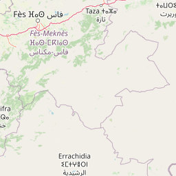
Map view of Tazekka National Park

Use this park location map to pinpoint Tazekka National Park in Morocco, understand its exact geographic position, and read its mapped placement within the surrounding landscape more clearly.

Pigeon | © OpenStreetMap contributors

Location context for Tazekka National Park

Taza Province
Park atlas

Compare nearby mountain landscapes and Middle Atlas conservation sites for your next discovery.

Explore National Parks and Protected Areas Near Tazekka National Park, Morocco
Continue your geographic exploration from Tazekka National Park by browsing other protected areas within Morocco's Middle Atlas region and surrounding terrains. Discover how diverse landscapes, including mountain forests, karst systems, and high-altitude peaks, are conserved across this part of North Africa.
National parkMorocco

Ifrane National Park: Protected Landscape and Geographic Context in Morocco

National park boundaries and mapped terrain.

Investigate Ifrane National Park, a designated national park in Morocco, and its contribution to the country's protected lands. This profile details its geographic location, providing context for its mapped presence and the natural landscapes it encompasses. Delve into the atlas-relevant features that define this protected area, focusing on its geographic identity within Morocco's natural heritage.

Area
500 km²
Established
2004
IUCN
II
Relief
Mountain
Watercolor illustration showing a landscape with green hills, vegetation, and distant mountains
National parkMorocco

Al Hoceima National Park: Morocco's Coastal and Marine Protected Wilderness

Explore dramatic cliffs, kelp forests, and marine biodiversity.

Al Hoceima National Park represents a significant protected coastal and marine area in northern Morocco, distinguished by its rugged 50-kilometer Mediterranean coastline featuring spectacular limestone cliffs. This national park offers an atlas-style view of a landscape transitioning from the Ibaqouyen Rif mountains to the sea, harboring rich marine biodiversity including significant osprey colonies and dolphin habitats. Discover the mapped extent of this wild protected territory and its unique ecological features.

Area
480 km²
Established
2004
IUCN
II
Relief
Mountain
National parkMorocco

Khenifra National Park: National Park Atlas and Mapped Protected Landscape

Geographic context and protected area mapping for Morocco.

Explore the atlas perspective of Khenifra National Park, a designated national park in Morocco. This page provides detailed geographic context, focusing on its mapped protected landscape and its role within the country's network of conservation areas. Understand the park's terrain and regional setting through structured geographic data.

Area
842 km²
Established
2008
Relief
Mountain
Climate
Mediterranean
National parkMorocco

Haut Atlas Oriental National Park: National Park Mapping and Protected Landscape Identity

Explore its mapped geography and regional atlas context.

Delve into the specifics of Haut Atlas Oriental National Park, a designated national park in Morocco. This page serves as a detailed atlas entry, focusing on the park's protected landscape characteristics, its defined geographic boundaries, and its significance within the national park system. Understand the terrain and regional context that shape this important natural area for focused discovery.

Area
490 km²
IUCN
II
Relief
Mountain
Climate
Alpine
National parkTlemcen Province

Tlemcen National Park National Park: Mapped Boundaries and Regional Geographic Context

Discover protected landscapes within Tlemcen Province.

Delve into Tlemcen National Park, an important protected landscape situated within Tlemcen Province. This detail page offers a focused exploration of its specific geographic identity, mapped park boundaries, and the natural terrain it encompasses, providing essential context for understanding its role in regional geography and protected land exploration within Algeria.

Area
82.25 km²
Established
1993
IUCN
II
Relief
Mixed relief
National park

Sierra de las Nieves National Park: Ancient Fir Forests and Karst Geography in Andalusia

Mapped protected landscape and unique geologic features

Sierra de las Nieves National Park stands as a remarkable protected area in Andalusia, Spain, celebrated for its world-leading Spanish fir forests and intricate karst topography. This national park showcases significant geological diversity, from towering limestone formations and deep caves to the striking red peridotite mountains of Sierra Bermeja. Its elevation, reaching Pico Torrecilla at 1,919 meters, offers a unique alpine landscape context within southern Europe, mapped for detailed geographic discovery and protected area exploration.

Area
939.3 km²
Established
1989
IUCN
II
Visitors
100K annual
Watercolor painting showing mountains, trees, and fields
National parkAndalusia

Sierra Nevada National Park: Protected Alpine Terrain and Geographic Context in Andalusia

Explore Spain's highest mountain range mapped across Andalusia's atlas.

Sierra Nevada National Park offers a profound exploration of Spain's highest alpine environments and a significant entry in the regional geography atlas. This protected area showcases classic glacial landforms, U-shaped valleys, and numerous high-mountain lakes, alongside a remarkable abundance of endemic plant species thriving in its unique microclimates. Understanding its mapped boundaries reveals a landscape vital for both biodiversity and watershed, situated prominently within the broader geographic context of Andalusia.

Area
858.83 km²
Established
1999
IUCN
II
Relief
Mountain
Watercolor illustration of a river flowing through wetlands with trees and distant hills
National parkHuelva

Doñana National Park National Park: Mapped Geography and Protected Landscape Context

Explore Huelva's key protected area and its regional geographic setting.

Delve into the structured geographic data and mapped boundaries of Doñana National Park. This entry highlights its identity as a national park within the Huelva region, providing essential context for understanding its protected landscape. MoriAtlas offers this detail to facilitate a clear, atlas-driven exploration of its natural terrain and its place in the broader geographic framework of Spain.

Area
543 km²
Established
1969
IUCN
II
Visitors
376.3K annual

Common questions about visiting, size, designation, and location context for Tazekka National Park

Tazekka National Park FAQs for park facts, access, geography, and protected area context
Find quick answers about Tazekka National Park, including protected-area facts, park geography, trail and visitor context, and how the park fits into its surrounding country and regional landscape.
MoriAtlas Explorer

Continue Your Protected Areas Search Across the Global Atlas

Deepen your exploration by continuing the structured search for national parks and protected areas worldwide. Utilize the comprehensive filtering capabilities to compare different conservation landscapes and refine your understanding of global park geography. Discover more about the distribution and characteristics of protected natural areas.

Global natural geography