
Mori Atlas logo
Wildlife reserveRefugio de Vida Silvestre Pasochoa

A critical refuge for montane cloud forest and high-elevation Andean páramo ecosystems.

Refugio de Vida Silvestre Pasochoa: Mapping the Protected Volcanic Landscapes of Pichincha

Refugio de Vida Silvestre Pasochoa serves as a vital protected area situated on the slopes of a collapsed stratovolcano in the Pichincha province of Ecuador. This reserve preserves one of the last remaining remnants of inter-Andean humid forest within a steep-walled crater amphitheater. The terrain transitions from dense montane cloud forest on the lower flanks to open páramo near the volcanic rim, offering a distinct record of the original vegetation once prevalent across the northern Andes.

Andean forestcloud forestpáramovolcanic craterwildlife refugebirdwatching
A stylized vector-style illustration of a rocky mountain peak framed by coniferous trees and grassy slopes in the foreground.

Refugio de Vida Silvestre Pasochoa

Wildlife reserve

Park overview

Structured park overview, official facts, and landscape profile for Refugio de Vida Silvestre Pasochoa

Refugio de Vida Silvestre Pasochoa park facts, protected area profile, and essential visitor context

Review the core facts for Refugio de Vida Silvestre Pasochoa, including designation, size, terrain, visitor scale, habitats, and operating context in one park-focused overview.

About Refugio de Vida Silvestre Pasochoa

Refugio de Vida Silvestre Pasochoa occupies the inter-Andean slopes of the Pasochoa volcano, an ancient and heavily eroded volcanic structure in the province of Pichincha. The refuge covers a relatively compact area of approximately 980 hectares, yet this footprint captures a remarkable vertical and ecological gradient that ranges from mid-elevation montane cloud forest to high grasslands inside the rim of the old crater.

The protected area falls within the parish of Uyumbicho in Mejía canton, with the city of Quito about 45 kilometers to the northwest and the town of Amaguaña nearby. Its boundaries are anchored to surrounding haciendas and private properties, including Hacienda Medrano to the north, Hacienda Pasochoa de Montúfar to the south, Hacienda Pedregales to the east, and several smallholdings along the western edge. The interface between the reserve and these agricultural estates is one of the defining characteristics of Pasochoa: it sits right at the contact line between the last continuous stretch of inter-Andean forest in central-northern Ecuador and the heavily modified agricultural and livestock landscape of the valley.

Pasochoa has been managed under a cooperation agreement with Fundación Natura, and its protected status has been important for safeguarding a forest that has served as a reference point for many scientific studies of Ecuadorian Andean vegetation composition. Today the refuge functions simultaneously as a conservation site, an environmental education site, and a nature tourism destination, attracting hikers and birdwatchers from Quito and beyond who come to experience both the forest interior and the open páramo and crater landscape above.

Quick facts and research context for Refugio de Vida Silvestre Pasochoa

Pasochoa is an Ecuadorian Wildlife Refuge located in the province of Pichincha, on the inter-Andean slopes of the collapsed Pasochoa volcano about 45 km southeast of Quito. Created on December 19, 1996 through Interministerial Agreement 065, it covers roughly 980 hectares and is administered by Ecuador's Ministry of Environment. The refuge is classified as an IUCN Category Ib area (wilderness/wildlife refuge) and is recognized by BirdLife International as Important Bird Area EC053.

Protection and recognition

Examine terrestrial protected area designations and management scope metrics.

Refugio de Vida Silvestre Pasochoa Protection Status and Designation Facts

Refugio de Vida Silvestre Pasochoa holds documented terrestrial protection status within official conservation inventories. Structured records assemble verified management scope parameters and international recognition sources for detailed analysis.

Protection details

Protection scope
Terrestrial
Transboundary protection
No
Park context

Deeper park guide and search-rich context for Refugio de Vida Silvestre Pasochoa

Refugio de Vida Silvestre Pasochoa history, landscape, wildlife, and travel context

Explore Refugio de Vida Silvestre Pasochoa through its history, landscape character, ecosystems, wildlife, conservation priorities, cultural context, and seasonal travel timing in a structured park guide built for atlas discovery and search intent.

Why Refugio de Vida Silvestre Pasochoa stands out

Pasochoa is best known as a refuge for the original Andean vegetation that once covered the central and northern highlands of Ecuador, including rare relict cloud forest and páramo habitats growing inside the crater of an extinct volcano. It is also recognized for protecting one of the key populations of the giant conebill (Oreomanes fraseri) and serving as a hotspot of hummingbird diversity in the northern Andes.
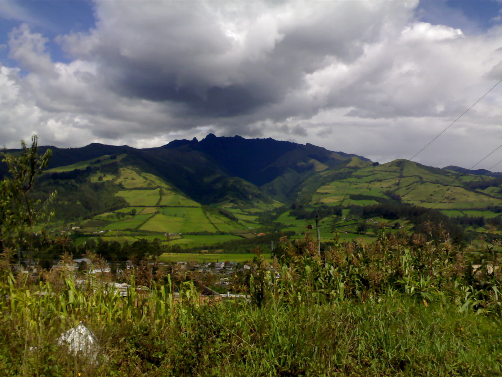
A wide shot of the Pasochoa volcano, a rugged, dark-forested mountain ridge rising above green fields and agricultural land under a cloudy sky.
View of the Pasochoa volcano from near Machachi, Ecuador.

Refugio de Vida Silvestre Pasochoa history and protected-area timeline

Pasochoa was formally established as a Wildlife Refuge on December 19, 1996, through Interministerial Agreement 065 published in Official Register 92. The designation came during a period in which Ecuador was consolidating its national system of protected areas and seeking to safeguard small but ecologically critical fragments of native vegetation in the densely populated Andean corridor near Quito.

Following its creation, the refuge was placed under a cooperation agreement with Fundación Natura, a leading Ecuadorian conservation NGO that took responsibility for its management through 2011. During this period, the area became an important site for research into the original composition of Andean forests, and it served as a focal point for environmental education initiatives aimed at communities in the surrounding agricultural valley. The fact that the refuge borders working livestock haciendas has shaped much of its ongoing conservation challenge, making the management history of Pasochoa closely tied to negotiations with neighboring land users and to efforts to limit the advance of deforestation at the forest margin. No subsequent modifications to its official designation have been recorded.

Refugio de Vida Silvestre Pasochoa landscape and geographic character

The physical setting of Pasochoa is dominated by the remains of an extinct, collapsed stratovolcano that rises above the surrounding inter-Andean valley. The slopes facing outward are deeply cut by erosion, while the interior of the former crater forms a steep-walled amphitheater that is one of the most distinctive visual features of the refuge. The landscape transitions upward from forested lower flanks to open páramo and bare volcanic ridges near the rim.

Outside the crater walls the terrain continues into rolling Andean slopes and small valleys that have been heavily modified by agricultural use. The contrast between the forested heart of the refuge and the surrounding patchwork of pastures, plantations, and small farms is one of the defining visual characteristics of the area. Frequent mist and cloud cover in the higher elevations give the upper forest and páramo a distinctly Andean character, with damp rock faces, mossy slopes, and shifting weather along the crater rim.

Refugio de Vida Silvestre Pasochoa ecosystems, habitats, and plant life

Pasochoa protects four ecological zones that together capture the altitudinal diversity typical of the Ecuadorian Andes. The refuge includes both lower and upper montane humid forest, as well as two types of páramo: grass páramo dominated by tussock vegetation and cushion páramo formed by low-growing cushion plants. This combination allows a wide variety of plant growth forms to coexist in a relatively small footprint.

Most of the forest within the reserve is in a secondary successional state, shaped by historical human use and grazing pressure on the lower margins, yet the steepest interior slopes of the crater still hold patches of primary vegetation that are extremely rare elsewhere in this part of Ecuador. The most ecologically valuable areas are concentrated where topography has limited access, leaving intact stands of Andean trees mixed with dense stands of Chusquea bamboo on the steepest slopes. The remnants of these original forests are considered scientifically important because they offer one of the few remaining windows into the composition of the pre-Columbian Andean forest cover of the region.

Botanical surveys have catalogued roughly 232 plant species, with a particularly rich presence of heliconias, bromeliads, ferns, and around 23 species of orchids including both terrestrial and epiphytic forms. Characteristic canopy trees include Andean alder (Alnus acuminata), pumamaqui (Oreopanax confusus and O. corazonensis), the Ecuadorian endemic Polylepis reticulata, and the wax palm Ceroxylon alpinum, a species traditionally harvested for religious decoration and now considered vulnerable in the Ecuadorian highlands.

Refugio de Vida Silvestre Pasochoa wildlife and species highlights

The wildlife profile of Pasochoa is exceptionally rich for an area of its size, and is one of the main reasons the refuge has drawn scientific attention. Birdlife is a centerpiece: roughly 117 bird species have been recorded, of which about 12 are restricted to the Northern Andean biome, and 15 are hummingbird species. The refuge is internationally recognized as an Important Bird Area partly because it supports an important population of the giant conebill (Oreomanes fraseri), a globally restricted species associated with Polylepis woodlands in the high Andes.

Several hummingbirds are emblematic of the reserve, including the sapphire-vented puffleg (Eriocnemis luciani), the sword-billed hummingbird (Ensifera ensifera), black-tailed trainbearer (Lesbia victoriae), shining sunbeam (Aglaeactis cupripennis), and the great sapphirewing (Pterophanes cyanopterus). Mammalian fauna documented at Pasochoa includes the opossum-like caenolestes (Caenolestes fuliginosus), the Ecuadorian shrew (Cryptotis equatoris), Andean cottontail rabbit (Sylvilagus brasiliensis), common opossum, culpeo fox (Lycalopex culpaeus), striped hog-nosed skunk, long-tailed weasel, white-tailed deer, the small red brocket deer of the páramo, the Andean coatí (Nasuella olivacea), and puma, indicating that the refuge still supports a functional assemblage of Andean mammal predators, herbivores, and small mammals despite its proximity to populated areas. The presence of these species together suggests that Pasochoa functions as a refuge where wildlife can move vertically between forest and páramo in a landscape otherwise dominated by farmland.

Refugio de Vida Silvestre Pasochoa conservation status and protection priorities

Pasochoa is significant as a conservation site because of what lies directly outside its boundaries. The refuge protects one of the last continuous stretches of inter-Andean humid forest in central-northern Ecuador, where deforestation driven by cattle ranching, agriculture, and pine plantations has historically advanced right up to the reserve's lower edge. Keeping this forest pocket intact is therefore disproportionately important for the regional landscape, since the habitat it contains is essentially a relict of the original vegetation that once covered the surrounding Andes.

The refuge has been formally recognized under the IUCN Category Ib system as a wildlife refuge, giving priority to the protection of wild species and natural ecological processes. Its listing as Important Bird Area EC053 by BirdLife International highlights its role in conserving restricted-range and montane forest bird species, including the giant conebill and a suite of high-elevation hummingbirds. The presence of Polylepis reticulata, an Ecuadorian endemic, and Ceroxylon alpinum, a vulnerable wax palm traditionally used in religious celebrations, adds a strong plant-conservation dimension. Management through the cooperative agreement with Fundación Natura has placed particular emphasis on environmental education and on stabilizing the forest margin against the encroaching agricultural and plantation landscape that surrounds the reserve on three sides. The conservation challenge at Pasochoa is not primarily internal degradation but rather reducing external pressures from a densely populated rural hinterland.

Refugio de Vida Silvestre Pasochoa cultural meaning and human context

Pasochoa lies within an area of long-standing rural Andean land use, where large haciendas dedicated to cattle ranching have shaped both the landscape and the social structure of the surrounding valleys for generations. The names of the bordering properties, such as Hacienda Medrano, Hacienda Pasochoa de Montúfar, and Hacienda Pedregales, reflect this heritage of large estates and landholdings that continue to mark the administrative and cultural geography around the refuge.

The cultural dimension of the reserve is also tied to traditional highland practices. The harvesting of the wax palm Ceroxylon alpinum for use in religious decorations during Holy Week is a centuries-old activity that has placed local pressure on this species, linking Pasochoa to living religious customs in the region. Closer to Quito, the refuge has become a familiar destination for environmental education outings and for residents of the capital and neighboring towns such as Amaguaña who use the trails within the reserve as a nearby space for contact with intact Andean forest and páramo.

Top sights and standout views in Refugio de Vida Silvestre Pasochoa

Pasochoa combines a compact but unusually complete Andean ecological gradient with immediate accessibility from Ecuador's largest city. The most distinctive highlight is the forested interior of an old volcanic crater, where primary forest and dense Chusquea bamboo stands survive on slopes too steep for agriculture. Surrounding that core, the high páramo along the crater rim offers open vistas over the central Andes and a sharp transition from forest to grassland within walking distance.

For birdwatchers, the refuge is a high-density Northern Andean bird area, harboring roughly 117 species and an unusually high concentration of hummingbirds, including the charismatic sword-billed hummingbird and sapphire-vented puffleg. The site also carries scientific weight as a reference area for reconstructing the original plant composition of Andean forests in central and northern Ecuador, and as a refuge for endemic and vulnerable tree species such as Polylepis reticulata and the Andean wax palm.

Best time to visit Refugio de Vida Silvestre Pasochoa

The comfortable seasons for visiting Pasochoa generally coincide with the drier months of the central Andes, when mist levels in the cloud forest and páramo tend to be lower and trail conditions are more stable for hiking. Mornings throughout the year tend to be calm and clear, which is when bird activity, especially hummingbird activity around flowering shrubs, is most visible. Hummingbird presence and flowering of heliconias, bromeliads, and orchids are typically most pronounced in the warmer, wetter months, while páramo scenery and broad vistas across the crater rim are most accessible during the drier period. Visitors should be prepared for sudden changes in weather at higher elevations regardless of season, as the Andean climate can shift rapidly from clear skies to heavy mist.

Monthly climate preview

Long-term representative coordinate measurements for temperature and monthly precipitation

Refugio de Vida Silvestre Pasochoa Climate Normals and Annual Weather Rhythm

Representative coordinates record measured monthly temperature ranges and precipitation rhythms across a multi-year climatology period. Examining the complete twelve-month record clarifies long-term environmental patterns across the protected terrain.
Annual mean14 °C
14 °C15 °C
Jan14°
Feb14°
Mar14°
Apr15°
May15°
Jun14°
Jul14°
Aug14°
Sep14°
Oct14°
Nov14°
Dec14°
Warmest month
April

14.6 °C

Coolest month
July

13.7 °C

Wettest month
April

6.1 mm/day

Driest month
August

1.1 mm/day

Park location guide

Geography guide, regional context, and park location map for Refugio de Vida Silvestre Pasochoa

Refugio de Vida Silvestre Pasochoa park geography, regions, and map view in Ecuador

Understand where Refugio de Vida Silvestre Pasochoa sits in Ecuador through a broader geographic reading of the surrounding landscape, nearby location context, and its mapped position within the national park landscape.

How Refugio de Vida Silvestre Pasochoa fits into Ecuador

Ecuador is a presidential republic located in northwestern South America, with Quito as its capital and Guayaquil as its largest city. The country spans 283,561 km² and encompasses the Galápagos Islands, a volcanic archipelago famous for unique wildlife that helped shape Darwin's theory of evolution. Ecuador is a plurinational state with Spanish as the official language, though Kichwa and Shuar are recognized for indigenous peoples.

Wider geography shaping Refugio de Vida Silvestre Pasochoa in Ecuador

Ecuador is located in northwestern South America along the Pacific coast. It shares borders with Colombia to the north and Peru to the east and south. The country includes the Galápagos Islands, a volcanic archipelago in the Pacific Ocean approximately 1,000 km west of the mainland. The territory encompasses diverse terrain including the Amazon rainforest in the east, the Andean highlands in the center, and coastal plains along the Pacific.

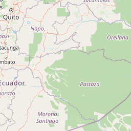
Map view of Refugio de Vida Silvestre Pasochoa

Use this park location map to pinpoint Refugio de Vida Silvestre Pasochoa in Ecuador, understand its exact geographic position, and read its mapped placement within the surrounding landscape more clearly.

Pigeon | © OpenStreetMap contributors

Location context for Refugio de Vida Silvestre Pasochoa

Pichincha

Explore visual records of Andean cloud forests, steep crater walls, and high altitude habitats

Refugio de Vida Silvestre Pasochoa Photos and Volcanic Crater Landscapes

Visual documentation captures the rugged topography and relict humid forests preserved inside the ancient volcanic crater. Protected area photography reveals the complex ecological gradient spanning from montane woodland to open Andean grassland.

A wide shot of the Pasochoa volcano, a rugged, dark-forested mountain ridge rising above green fields and agricultural land under a cloudy sky.

Park atlas

Compare surrounding Andean highland terrain and regional conservation landscapes

Explore Protected Areas and Parks Near Refugio de Vida Silvestre Pasochoa

Browse nearby national parks and protected areas sharing similar high-elevation Andean mountain geography and cloud forest habitats. Continuing your geographic comparison across the surrounding region reveals broader patterns in regional park distribution.
National parkCotopaxi Province
About 12 km away#1 closest

South

Cotopaxi National Park: Ecuador's Mapped Protected Landscape and Regional Geography

Explore the geographic context of this national park.

Cotopaxi National Park represents a key protected landscape within Ecuador, located in Cotopaxi Province. This page facilitates detailed exploration of the park's mapped boundaries and its contribution to the regional geography. Understand the specific characteristics of this national park as part of a broader atlas of protected areas and natural terrains.

Area
333.93 km²
Established
1975
IUCN
II
Relief
Mountain
A wide watercolor illustration showing a misty landscape with green trees in the midground and faint mountain peaks in the background.
Nature reserveEcuador
About 16 km away#2 closest

Southwest

Reserva Ecológica Los Illinizas: Geographic Atlas and Andean Protected Nature Reserve

Volcanic terrain and cloud forest ecosystems in central Ecuador

Spanning across the provinces of Cotopaxi, Pichincha, and Santo Domingo de los Tsáchilas, Reserva Ecológica Los Illinizas preserves a significant vertical gradient of Andean ecosystems. The reserve protects the western flanks of the Illiniza volcanoes, Quilotoa, and El Corazón, offering a detailed look at high-altitude biodiversity and the transition from rugged mountain peaks to lush western cloud forests.

Area
1,342.33 km²
Established
1996
IUCN
Ia
Relief
Mountain
Watercolor illustration of a winding path through a green landscape with snow capped mountains in the distance against a pink sky.
National parkNapo
About 27 km away#3 closest

East

Parque nacional Antisana: Volcanic Terrain and Andean Protected Area Geography

High-altitude ecosystems spanning Napo and the Andean corridor

Spanning the rugged Cordillera Real, Parque nacional Antisana protects a vast sweep of volcanic terrain dominated by its central stratovolcano. From glacial fields to the water-retention capacity of its páramo wetlands, the area represents a crucial node in Ecuador's conservation network, providing a sanctuary for Andean condors and diverse montane species.

Area
1,205.81 km²
Established
1993
IUCN
Ia
Relief
Mountain
National parkEcuador
About 47 km away#4 closest

South

Llanganates National Park: Detailed Atlas Entry for Ecuador's Protected Landscape

Explore the mapped geography and regional context of this Ecuadorian national park.

Llanganates National Park is a designated national park offering rich opportunities for geographic and landscape exploration. As a significant protected area in Ecuador, it provides crucial context for understanding the country's natural terrain and the distribution of its conservation landscapes. This entry is designed to facilitate an atlas-style discovery of the park's location, boundaries, and its role within the broader geography of the region.

Area
2,197.07 km²
Established
1996
IUCN
II
Relief
Mountain
Biosphere reserveNapo
About 54 km away#5 closest

Southeast

Reserva Biológica Colonso-Chalupas: Protected Landscapes of the Upper Napo Basin

A critical vertical corridor of the Ecuadorian Andes and Amazon.

Reserva Biológica Colonso-Chalupas represents a unique bioclimatic transition, stretching nearly 4,000 meters in elevation. This biosphere reserve serves as a functional corridor connecting high-altitude páramo and cloud forests to warm, humid Amazonian lowlands, forming a key structural element of the eastern Andean conservation landscape.

Area
931.63 km²
Established
2014
Relief
Mountain
Climate
Alpine
Watercolor illustration showing a panoramic view of a wide valley with green hills, a small stream, and forested clusters, rendered in a light and airy style.
Nature reservePichincha
About 54 km away#6 closest

North

Reserva Geobotánica Pululahua: Protected Volcanic Caldera and Highland Ecosystems

A distinct geobotanical reserve in the Pichincha region of the Ecuadorian Andes.

Reserva Geobotánica Pululahua is a protected natural area centered on a massive, 12-kilometer-wide volcanic caldera. Its landscape features three prominent lava domes and a rare altitudinal gradient of vegetation, spanning from semi-dry mountain shrubland to dense cloud forest. This reserve serves as a critical study of volcanic geology and human-landscape interaction in the high Andes, offering a concentrated look at Ecuador's vertical ecological zonation.

Area
34.417 km²
Established
1966
Relief
Mountain
Climate
Subtropical
National parkEcuador
About 77 km away#7 closest

East

Sumaco Napo-Galeras National Park: Ecuador's Volcanic National Park Landscape

Explore protected areas and biodiversity in the Andean-Amazon transition.

Sumaco Napo-Galeras National Park protects a dramatic volcanic landscape in Ecuador, showcasing a significant elevation gradient that supports diverse cloud forest and Amazonian rainforest habitats. This national park is recognized for its endemic species and rich avifauna, offering a compelling case study for understanding protected land geography and ecological transitions within South America.

Area
2,067.49 km²
Established
1994
IUCN
II
Relief
Mountain
A horizontal watercolor painting showing layers of rolling green hills, a pink-toned foreground meadow, and distant hazy mountain ridgelines against a light background.
National parkImbabura
About 84 km away#8 closest

North

Cotacachi Cayapas National Park: A Study of Andean and Chocó Protected Geographic Landscapes

Exploring the extreme vertical transition across the northern Ecuadorian Andes

Cotacachi Cayapas National Park stands as a vital protected area, linking high-altitude páramo around Volcán Cotacachi to the lowland forests of the Chocó. The park features the iconic Laguna de Cuicocha and a dramatic range of ecosystems that define its complex terrain. This resource offers a clear look at the park's boundaries, geological features, and the distinct ecological zones that make it a central pillar of northern Ecuadorian geography.

Area
2,609.61 km²
Established
1968
IUCN
II
Visitors
50.2K annual

Common questions about visiting, size, designation, and location context for Refugio de Vida Silvestre Pasochoa

Refugio de Vida Silvestre Pasochoa FAQs for park facts, access, geography, and protected area context

Find quick answers about Refugio de Vida Silvestre Pasochoa, including protected-area facts, park geography, trail and visitor context, and how the park fits into its surrounding country and regional landscape.
MoriAtlas Explorer

Continue Your Protected Areas Search Across the Global Atlas

Deepen your exploration by continuing the structured search for national parks and protected areas worldwide. Utilize the comprehensive filtering capabilities to compare different conservation landscapes and refine your understanding of global park geography. Discover more about the distribution and characteristics of protected natural areas.

Global natural geography