
Mori Atlas logo
Nature reservePennewitzer Teiche und Unteres Wohlrosetal

Discover the geographic mosaic of pond chains, brook valleys, and damp moor woodland habitats.

Pennewitzer Teiche und Unteres Wohlrosetal: A Protected Nature Reserve Landscape in Thuringia

(Naturschutzgebiet Pennewitzer Teiche und Unteres Wohlrosetal)

Pennewitzer Teiche und Unteres Wohlrosetal forms a distinct nature reserve in Thuringia, characterized by a dense concentration of approximately one hundred water bodies. This protected landscape combines historic fishponds with abandoned blasting pits, creating a complex wetland mosaic framed by the Lohme, Ilm, and Wohlrose stream valleys. The surrounding Schönheide forest enhances the area with its humid moor woodland, offering a unique look at central German riparian geography.

nature reserveThuringiaponds and wetlandsforest landscapemoor woodlandbrook valleys
A graphic illustration showing a mountain valley with a waterfall cascading down rocky cliffs into a winding river through a pine forest.

Pennewitzer Teiche und Unteres Wohlrosetal

Nature reserve

Park overview

Structured park overview, official facts, and landscape profile for Pennewitzer Teiche und Unteres Wohlrosetal

Pennewitzer Teiche und Unteres Wohlrosetal park facts, protected area profile, and essential visitor context

Review the core facts for Pennewitzer Teiche und Unteres Wohlrosetal, including designation, size, terrain, visitor scale, habitats, and operating context in one park-focused overview.

About Pennewitzer Teiche und Unteres Wohlrosetal

Pennewitzer Teiche und Unteres Wohlrosetal is a Thuringian nature reserve that weaves together stream valleys, historic pond complexes, and damp forest into a single contiguous protected landscape. It sits north of Gehren, in the part of Thuringia where the Ilm-Kreis meets the Landkreis Saalfeld-Rudolstadt, a region defined by deeply incised valleys of the Thuringian slate uplands.

The protected area is essentially a water-shaped landscape. The Lohme and the Ilm flow along its western edge, while the Wohlrose defines the eastern boundary. Between them, the reserve contains a chain of named pond groups. In the southwest, near the edge of Gehren, the Lohme valley includes the Heideteich and the Löschwasserteiche. In the northwest, in the Ilm valley, lie the Herrenteiche. In the center sits the Esbachteich, also called the Seerosenteich for its water lilies. Along the Wohlrose in the east are the Zweizapfenteiche and the Sorger Teiche.

The Schönheide forest occupies the space between these pond clusters. Across this forest the landscape is dotted with Sprenglöcher, pits left by historical blasting that have since filled with water, forming roughly one hundred small ponds and pools in total. The combination of high groundwater, slow-flowing streams, and these ponds has allowed moor-like woodland (Moorwald) to develop, giving the reserve a humid, soft character distinct from the surrounding dry upland forests.

Culturally, the ponds reflect a long tradition of small-scale fish farming and water management in the Thuringian forest-fringe communities. Ecologically, that legacy now serves conservation, because the variety of pond types, from open water lily ponds to shaded moor-woodland pools, supports diverse amphibian, aquatic invertebrate, and wetland plant communities. The neighboring settlements of Langewiesen, Gräfinau-Angstedt, Pennewitz, Jesuborn, and Gehren frame the reserve on all sides, which underscores how tightly the protected landscape is woven into the inhabited cultural region east of the Ilm valley.

Quick facts and research context for Pennewitzer Teiche und Unteres Wohlrosetal

Located in the Ilm-Kreis and the Landkreis Saalfeld-Rudolstadt in Thuringia, north of Gehren. Designated as a Naturschutzgebiet in 2004 and registered with the World Database on Protected Areas under WDPA ID 329571. The full protected area covers about 419.2 hectares, even though the broader listing reference of 4,246 km² reflects the regional context rather than the reserve itself.

It is classified under IUCN Category IV, denoting a habitat or species management area. Administratively, it falls under the Ilm-Kreis. The reserve encompasses around 100 ponds and water-filled hollows, clustered into distinct pond groups separated by forest, and is fed by the Lohme, the Ilm, and the Wohlrose streams.

Protection and recognition

Review documented protection status and official database records for this protected area.

Protection Status and International Recognition for Pennewitzer Teiche und Unteres Wohlrosetal

Pennewitzer Teiche und Unteres Wohlrosetal protection status details bring together official database records and management context. Protected area designation parameters and administrative sources outline the formal conservation framework for the landscape.

Protection details

WDPA ID
329571
Park context

Deeper park guide and search-rich context for Pennewitzer Teiche und Unteres Wohlrosetal

Pennewitzer Teiche und Unteres Wohlrosetal history, landscape, wildlife, and travel context

Explore Pennewitzer Teiche und Unteres Wohlrosetal through its history, landscape character, ecosystems, wildlife, conservation priorities, cultural context, and seasonal travel timing in a structured park guide built for atlas discovery and search intent.

Why Pennewitzer Teiche und Unteres Wohlrosetal stands out

The reserve is best known for its extraordinary density of small ponds and water-filled hollows grouped within a continuous forest setting. Roughly one hundred ponds, most of them either historic fishponds or flooded former quarry or blasting pits (Sprenglöcher), are spread across the protected landscape. The habitat character this creates, including wet woodland, marshy margins, and open water rich in amphibians and aquatic vegetation, is the reserve's central identity. The pairing of named historic pond groups with the Schönheide forest gives the area a distinctive layered landscape where stream valley, pond chain, and damp woodland alternate in a remarkably compact area.
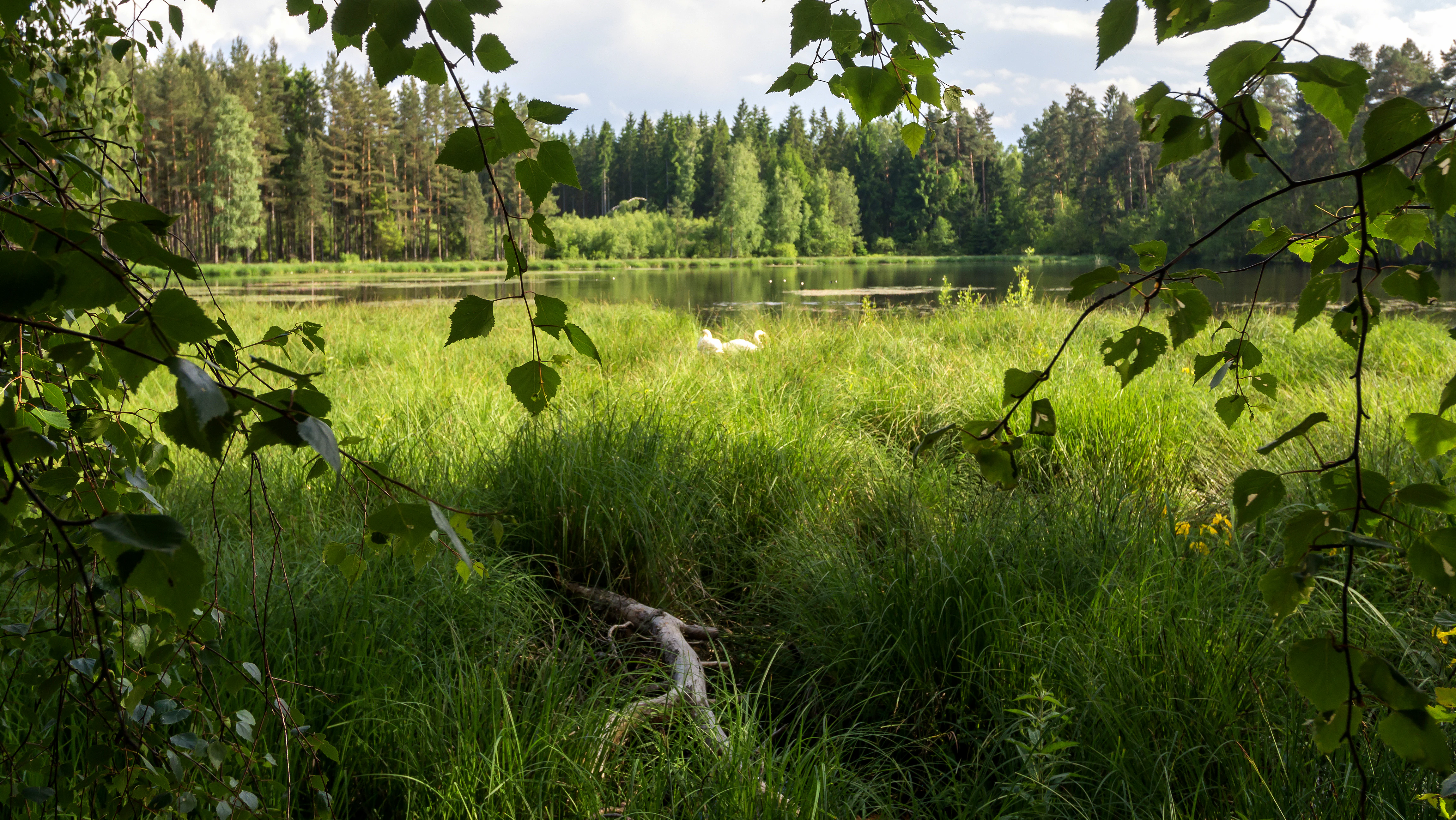
A peaceful pond framed by overhanging birch branches, featuring tall grasses in the foreground and a dense forest line in the background.
A view of the Zweizapfenteich pond, surrounded by lush vegetation and forest within the nature reserve.

Pennewitzer Teiche und Unteres Wohlrosetal history and protected-area timeline

The protected area was formally designated in 2004 as the Naturschutzgebiet Pennewitzer Teiche und Unteres Wohlrosetal, falling under the responsibility of the Ilm-Kreis administration. It is also tracked internationally through the World Database on Protected Areas under ID 329571 and classified at IUCN Category IV.

Before designation, the landscape had already been shaped by centuries of small-scale water use. The pond groups named within the reserve, including the Herrenteiche, Esbachteich, Zweizapfenteiche, and Sorger Teiche, point to a long tradition of pond-based land use typical of the Thuringian forest-fringe villages. The presence of Sprenglöcher through the Schönheide forest also shows that parts of the area were affected by historic mining or quarrying activity, whose pits were later reclaimed by nature as wet hollows. The reserve's establishment in 2004 formalized the protection of this layered, human-influenced but ecologically rich mosaic.

Pennewitzer Teiche und Unteres Wohlrosetal landscape and geographic character

The reserve occupies a compact valley-and-forest landscape north of Gehren. From west to east, three small valley systems frame the protected area: the Lohme valley in the southwest, the Ilm valley in the northwest, and the Wohlrose valley along the eastern edge. These brooks and small river channel the area's topography and feed its pond systems.

Between the valleys, the Schönheide forest stretches across the central part of the reserve. Its terrain is gently undulating upland woodland, broken by the many water-filled Sprenglöcher that now read as a scattered chain of tiny ponds. Because of the high water table and the streams feeding the area, parts of this woodland have developed into damp Moorwald, giving the forest a notably humid character compared with surrounding dry upland forests.

The overall impression is of a forested, water-rich basin at the seam between two Thuringian districts. Elevation changes are modest, and most of the visual interest comes from the alternation between shaded woodland, open pond surfaces, and quiet meadow-like edges around the historic fishponds.

Pennewitzer Teiche und Unteres Wohlrosetal ecosystems, habitats, and plant life

Ecologically, the reserve is a wetland-and-woodland complex rather than a single, uniform habitat. Its three defining habitat types are open water in the form of around one hundred ponds, damp forest including Moorwald in the Schönheide area, and the narrow stream corridors of the Lohme, the Ilm, and the Wohlrose.

The pond clusters differ in character because of their position. The Herrenteiche in the Ilm valley and the Esbachteich (Seerosenteich) in the middle of the reserve behave as more open, vegetated ponds with floating plants such as water lilies. In contrast, the ponds inside the Schönheide forest are heavily shaded, small, and embedded in woodland, creating a very different microhabitat. Along the Wohlrose, the Zweizapfenteiche and Sorger Teiche sit at the edge of the brook and combine inflowing stream water with standing pond conditions.

This habitat diversity within a relatively small reserve is what makes the area ecologically significant. Wet woodland, marshy margins, slow-moving brooks, and open ponds together support the amphibians, aquatic invertebrates, and wetland plants for which the reserve is protected.

Pennewitzer Teiche und Unteres Wohlrosetal wildlife and species highlights

The wildlife profile of Pennewitzer Teiche und Unteres Wohlrosetal is shaped first and foremost by its rich pond network. The roughly one hundred ponds and water-filled hollows, set among connected stream valleys and damp forest, provide breeding and shelter conditions for amphibians across the protected area.

The combination of open ponds like the Esbachteich, shaded forest pools inside the Schönheide, and stream margins along the Wohlrose and Ilm supports a mixture of amphibian species adapted to open sun-exposed water and others that prefer cooler, more sheltered woodland pools. Aquatic invertebrate communities likewise benefit from the range of pond sizes, water depths, and vegetation cover.

Birdlife is typically associated with the mix of pond edges, wet woodland, and quiet forest interior, while the broader mammal and insect fauna of the Thuringian forest fringe continues into the reserve through its wooded sections. The area's wildlife significance is therefore less about any single rare species and more about the consistent wetland habitat base it provides across the landscape.

Pennewitzer Teiche und Unteres Wohlrosetal conservation status and protection priorities

The reserve is designated under IUCN Category IV as a Habitat/Species Management Area, meaning its primary purpose is the active conservation and management of habitats and species rather than strict wilderness protection. It was formally established as a Naturschutzgebiet in 2004 and is listed internationally through the World Database on Protected Areas (WDPA ID 329571).

The core conservation value lies in the unusually high pond density within a relatively small, forested landscape. Roughly one hundred ponds, supplemented by old Sprenglöcher that have become natural water bodies, create a network of breeding and refuge sites for amphibians, aquatic invertebrates, and wetland plants. The presence of Moorwald, a relatively uncommon wet woodland type in the region, adds further conservation weight.

Protection of the area also serves to maintain the cultural-natural character of the Thuringian pond landscape. Historic fishponds such as the Herrenteiche, Zweizapfenteiche, and Sorger Teiche are conserved alongside the more recently formed forest ponds, ensuring that both the inherited and the spontaneously regenerated wetland elements remain intact for the long term.

Pennewitzer Teiche und Unteres Wohlrosetal cultural meaning and human context

The reserve belongs to a region with a long tradition of small-scale pond farming and water management in the villages around the Thuringian Forest. The named pond groups, including the Herrenteiche, Esbachteich, Zweizapfenteiche, Sorger Teiche, Heideteich, and Löschwasserteiche, reflect generations of local use of water for fishponds, livestock watering, and fire-water storage close to the town of Gehren.

Even the Sprenglöcher inside the Schönheide reflect a partly industrial past: they are the legacy of historic blasting or quarrying, and their transformation into forest pools shows how the local community and landscape have gradually been overtaken by natural wetland processes. Today, the villages of Langewiesen, Gräfinau-Angstedt, Pennewitz, Jesuborn, and Gehren still border the reserve, illustrating the close coexistence of inhabited countryside and protected nature typical of Thuringia.

Top sights and standout views in Pennewitzer Teiche und Unteres Wohlrosetal

A standout feature is the sheer density of ponds: about one hundred water bodies distributed across a compact protected landscape, ranging from open water-lily ponds like the Esbachteich to small shaded pools inside the Schönheide forest.

Equally notable is the stream-pond-forest mosaic itself, where the Lohme, Ilm, and Wohlrose frame three pond clusters and the Schönheide carries the Moorwald fragments. The reserve's quiet setting north of Gehren, on the border between Ilm-Kreis and Landkreis Saalfeld-Rudolstadt, gives it a peaceful, layered identity that combines wetland ecology with the cultural pond heritage of Thuringia.

Best time to visit Pennewitzer Teiche und Unteres Wohlrosetal

The reserve is a year-round wetland and forest landscape, so the character of a visit changes noticeably with the seasons. Spring and early summer are the most ecologically active periods, when pond margins fill with vegetation, water lilies surface in the Esbachteich, and amphibian activity around the roughly one hundred ponds is at its peak.

Late spring into early autumn is generally the most comfortable period for walking the forest and pond edges, when paths around the Herrenteiche, the Schönheide, and the Wohlrose valley are easily followed and the interplay of water and forest is most visible. In winter, the area becomes quieter and colder, with frozen pond surfaces and bare deciduous woodland offering a more muted, structural view of the same landscape.

Monthly climate preview

Long-term temperature ranges and monthly precipitation averages recorded across the protected landscape

Pennewitzer Teiche und Unteres Wohlrosetal Climate Normals and Annual Weather Patterns

Representative coordinates record measured monthly averages from sub-zero winter lows to warm summer highs alongside steady precipitation levels throughout the year. Examining the full twelve-month profile provides complete historical climate data for researchers studying the regional environment.
Annual mean8 °C
-2 °C18 °C
Jan-2°
Feb-1°
Mar
Apr
May12°
Jun16°
Jul18°
Aug18°
Sep13°
Oct
Nov
Dec-1°
Warmest month
July

18 °C

Coolest month
January

-2.1 °C

Wettest month
July

2.7 mm/day

Driest month
April

1.4 mm/day

Park location guide

Geography guide, regional context, and park location map for Pennewitzer Teiche und Unteres Wohlrosetal

Pennewitzer Teiche und Unteres Wohlrosetal park geography, regions, and map view in Germany

Understand where Pennewitzer Teiche und Unteres Wohlrosetal sits in Germany through a broader geographic reading of the surrounding landscape, nearby location context, and its mapped position within the national park landscape.

How Pennewitzer Teiche und Unteres Wohlrosetal fits into Germany

Germany is a federal republic in Western and Central Europe with a population of over 83 million across sixteen constituent states. It is Europe's largest economy by nominal GDP and a major global exporter and importer. The capital is Berlin, and the country borders Denmark, Poland, Czech Republic, Austria, Switzerland, France, Luxembourg, Belgium, and the Netherlands.

Wider geography shaping Pennewitzer Teiche und Unteres Wohlrosetal in Germany

Germany is located in Western and Central Europe, spanning 357,022 km². It borders Denmark to the north, Poland and the Czech Republic to the east, Austria and Switzerland to the south, and France, Luxembourg, Belgium, and the Netherlands to the west. The country has coastlines on the Baltic Sea and North Sea to the north, with the Alps located in the southern region.

Map view of Pennewitzer Teiche und Unteres Wohlrosetal

Use this park location map to pinpoint Pennewitzer Teiche und Unteres Wohlrosetal in Germany, understand its exact geographic position, and read its mapped placement within the surrounding landscape more clearly.

Pigeon | © OpenStreetMap contributors

Location context for Pennewitzer Teiche und Unteres Wohlrosetal

Thuringia

Visualizing the historic ponds, brook valleys, and wetland habitats of Thuringia

Pennewitzer Teiche und Unteres Wohlrosetal Landscape Photography and Protected Area Scenery

Visual records capture the dense network of fishponds, flooded woodland hollows, and stream corridors defining the protected terrain. Photographic documentation reveals the humid forest mosaic and quiet water bodies that shape the regional ecology.

A peaceful pond framed by overhanging birch branches, featuring tall grasses in the foreground and a dense forest line in the background.

Park atlas

Compare adjacent wetland habitats, forest reserves, and valley ecosystems across Thuringia

Parks Near Pennewitzer Teiche und Unteres Wohlrosetal and Regional Protected Landscapes

Browse other protected areas and nature reserves located near Pennewitzer Teiche und Unteres Wohlrosetal to examine wider Thuringian wetland geography. Expanding the regional park comparison reveals how local stream valleys and forest ponds connect to broader conservation networks.
A soft watercolor illustration of a pond landscape with green reeds in the foreground, calm water in the midground, and distant rolling hills in the background.
Nature reserveIlm-Kreis
About 7.1 km away#1 closest

West

Ilmenauer Teichgebiet: Wetland Landscape and Protected Nature Reserve Atlas

Mapped pond system and geographic terrain in Ilm-Kreis

The Ilmenauer Teichgebiet nature reserve is defined by its six interconnected ponds, which create a significant wetland complex on the eastern edge of Ilmenau. Anchored by the Grosser Teich and supported by a gypsum basin, this area preserves both the history of medieval fish farming and critical habitats for waterbirds and amphibians, offering a unique look at the regional geography of central Thuringia.

Area
0.58 km²
Established
2002
IUCN
IV
Relief
Lowland
Nature reserveThuringia
About 10 km away#2 closest

North

Willinger Berg Nature Reserve: Exploring the Geography and Forested Terrain of the Ilm-Saale-Platte

A prominent muschelkalk limestone outlier in Thuringia

Willinger Berg stands out for its double-peaked silhouette and geological significance as a Zeugenberg. The 83.8 hectare nature reserve includes protected beech forests and karst features that define the slopes above the surrounding villages. This study traces its role as a regional landmark and its position within the complex watershed of the Ilm and Unstrut basins.

Area
0.838 km²
Relief
Mountain
Climate
Temperate
Scope
Terrestrial
Nature reserveThuringia
About 11 km away#3 closest

Northwest

Veronikaberg Nature Reserve: Protected Muschelkalk Ridge and Forest Landscapes in Thuringia

Geographic overview of the southern Reinsberge range.

Veronikaberg functions as a critical nature reserve at the southeastern edge of the Ohrdrufer Platte. The landscape is defined by its Muschelkalk geology, which supports a unique microclimate for beech and yew forests. This record details the park boundaries and the terrain transitions that characterize this significant conservation site in central Germany.

Area
1.161 km²
Established
1961
Relief
Mountain
Water
No major water
Nature reserveThuringia
About 14 km away#4 closest

Northwest

Werra bis Treffurt mit Zuflüssen: Protected River and Floodplain Network in Thuringia

Mapping an extensive 191 kilometer Natura 2000 river corridor.

The Werra bis Treffurt mit Zuflüssen protected area serves as a vital ecological corridor in Thuringia. This site encompasses a complex mosaic of fast-flowing highland brooks, expansive floodplain meadows, inland salt sites, and rare dissolution lakes. Its geography bridges high-altitude source regions with lower river valleys, creating a distinctive landscape transect that supports essential freshwater habitats and rare aquatic species across the state.

Area
22.6 km²
Established
2008
IUCN
IV
Relief
Mixed relief
Nature reserveThuringia
About 14 km away#5 closest

North

Hohes Kreuz Nature Reserve: Mapping Forest Conservation in the Ilm District of Thuringia

A preserved oak-hornbeam landscape within the central German agricultural mosaic.

Hohes Kreuz is a protected nature reserve in Thuringia, Germany, renowned for preserving a residual oak-hornbeam forest on a Muschelkalk plateau. The site functions as an ecological refuge, supporting a wide variety of bird species and broadleaf vegetation while providing a striking contrast to the surrounding farmland of the Ilm district.

Area
0.105 km²
Established
1961
IUCN
IV
Relief
Upland
A soft watercolor illustration showing gentle, rolling green hills and a small patch of wildflowers in the foreground on a white background.
Protected areaThuringia
About 16 km away#6 closest

Northeast

Großer Kalmberg Protected Area: Geography and Landscape of the Ilm-Saale-Platte

Examining the asymmetric summit and calcareous habitats in central Thuringia.

Großer Kalmberg rises as a focal point of the Ilm-Saale-Platte, offering a clear view into the geological history of the region. This summit integrates pine-forested slopes with protected dry grasslands and rocky outcrops, creating a complex mosaic of terrain that characterizes this part of Thuringia.

Area
2.64 km²
Established
1999
Relief
Mountain
Climate
Temperate
Nature reserveIlm-Kreis
About 18 km away#7 closest

Northwest

Gottesholz Nature Reserve: Mapping the Protected Landscapes of Ilm-Kreis, Thuringia

A study of shell-limestone woodland geography

Gottesholz serves as an essential nature reserve in Ilm-Kreis, defined by its porous shell-limestone bedrock and rich, diverse vegetation. This detailed view covers the physical landscape, the strict forest reserve status, and the ecological markers that define this distinctive central German site.

Area
0.593 km²
Established
1961
IUCN
IV
A soft watercolor illustration of a bog landscape featuring layers of green coniferous trees, a flat horizon, and distant, faint pink hills against a white background.
Nature reserveThuringia
About 24 km away#8 closest

West

Schützenbergmoor Nature Reserve: Highland Bog Landscape in Thuringia, Germany

Examining protected wetland terrain and bog ecology

Schützenbergmoor is an essential protected area for understanding highland raised bog ecosystems in the Thuringian Forest. This small, high-altitude site illustrates the intersection of peatland formation and cool, moist regional geography, offering a window into the specialized wetland terrain and microclimates that define this protected landscape in central Germany.

Area
0.052 km²
Established
1967
Relief
Upland
Climate
Temperate

Common questions about visiting, size, designation, and location context for Pennewitzer Teiche und Unteres Wohlrosetal

Pennewitzer Teiche und Unteres Wohlrosetal FAQs for park facts, access, geography, and protected area context

Find quick answers about Pennewitzer Teiche und Unteres Wohlrosetal, including protected-area facts, park geography, trail and visitor context, and how the park fits into its surrounding country and regional landscape.
MoriAtlas Explorer

Continue Your Protected Areas Search Across the Global Atlas

Deepen your exploration by continuing the structured search for national parks and protected areas worldwide. Utilize the comprehensive filtering capabilities to compare different conservation landscapes and refine your understanding of global park geography. Discover more about the distribution and characteristics of protected natural areas.

Global natural geography