
Mori Atlas logo
Marine protected areaPerhentian Islands

Mapping the island archipelago and protected marine boundaries off the Terengganu coast

Perhentian Islands Marine Protected Area: A Geographic Atlas of Tropical Reef Landscapes

The Perhentian Islands comprise a nine-island archipelago situated in the South China Sea, representing a significant marine protected area off the coast of Terengganu, Malaysia. This geographic portrait examines the reef systems, white coral sand shorelines, and forested interior topography that define this unique tropical setting. Access detailed insights into the mapped boundaries and spatial distribution of these protected waters, which remain vital for coral health and local marine conservation efforts.

marine parkisland archipelagotropical islandscoral reefsscuba divingsnorkeling
An illustrative style image of a dramatic mountain valley featuring cliffs, two waterfalls, and a forested foreground at sunset.

Perhentian Islands

Marine protected area

Park overview

Structured park overview, official facts, and landscape profile for Perhentian Islands

Perhentian Islands park facts, protected area profile, and essential visitor context

Review the core facts for Perhentian Islands, including designation, size, terrain, visitor scale, habitats, and operating context in one park-focused overview.

About Perhentian Islands

The Perhentian Islands form a compact tropical archipelago on the eastern coast of Peninsular Malaysia, lying within view of the Terengganu mainland. Composed of nine islands in total, the group is anchored by two inhabited islands, Perhentian Besar and Perhentian Kecil, with Perhentian Besar the larger of the pair and Perhentian Kecil the more closely associated with backpacker-style tourism. Around them sit seven uninhabited islands, including Susu Dara, Rawa, and Serenggeh, which contribute to the broader reef habitat and occasionally serve as day-trip dive and snorkel sites.

The islands' defining feature is the meeting of soft coral sand beaches, fringing reefs, and warm clear water, creating a setting strongly oriented toward marine recreation. Dozens of dive and snorkel sites ring the two main islands, where visitors commonly encounter clownfish, cuttlefish, blue-spotted rays, blacktip reef sharks, and the occasional sea turtle gliding over the reef. Inland, the islands remain relatively undeveloped. Jungle trails connect the main beaches of each island, and there are no paved roads or airstrips, with virtually all transport handled by speedboat from Kuala Besut on the mainland.

The Perhentian Islands carry a layered history. Long before they became a tourism draw, they functioned as a stopping point for regional traders, including salt ships from Singgora heading to Kuala Terengganu, with the Malay name 'Perhentian' directly meaning a place of rest or pause. During the 20th century the group appeared on British colonial maps as 'The Station Islands', an English rendering of that same idea. After being sparsely inhabited by fishers for generations, and briefly serving as a landing point for Vietnamese refugees in the 1970s, the islands transitioned into one of Malaysia's signature nature tourism destinations. Today they balance marine park protection, a small permanent fishing community, and a seasonal influx of visitors drawn by the reef environment.

Quick facts and research context for Perhentian Islands

The Perhentian Islands sit within the South China Sea, off the Terengganu coast in Peninsular Malaysia, and fall administratively within the Besut District. The archipelago comprises nine islands, with Perhentian Besar and Perhentian Kecil functioning as the only inhabited land units and the main centers of visitor activity. The islands were designated a marine park by Malaysia's Department of Fisheries in 1994, with no fishing permitted within approximately two nautical miles of the shore.

The two main islands are connected to the mainland by speedboat services from Kuala Besut, as there are no paved roads or airstrips. Ecologically, the Perhentians are known for healthy fringing reefs, regular sea turtle nesting, and a tropical climate shaped by a strong northeast monsoon that effectively closes much of the islands to tourism between November and February.

Protection and recognition

Documented protection history and international recognition records for Perhentian Islands

Perhentian Islands Protection Status and Designated Area History

Perhentian Islands maintains a documented protection status established in 1994 with a mixed management scope. Records outline official designation history and international recognition data without imported external programs.

Protection details

Protection scope
Mixed
Designated year
1994
Transboundary protection
No
Park context

Deeper park guide and search-rich context for Perhentian Islands

Perhentian Islands history, landscape, wildlife, and travel context

Explore Perhentian Islands through its history, landscape character, ecosystems, wildlife, conservation priorities, cultural context, and seasonal travel timing in a structured park guide built for atlas discovery and search intent.

Why Perhentian Islands stands out

The Perhentian Islands are best known for exceptionally clear tropical water, white coral sand beaches, and an accessible coral reef system that supports sea turtles, reef sharks, rays, and a wide variety of reef fish. The archipelago is also recognized for its sea turtle conservation effort, including hatchery programs run for green and hawksbill turtles that nest on its beaches.
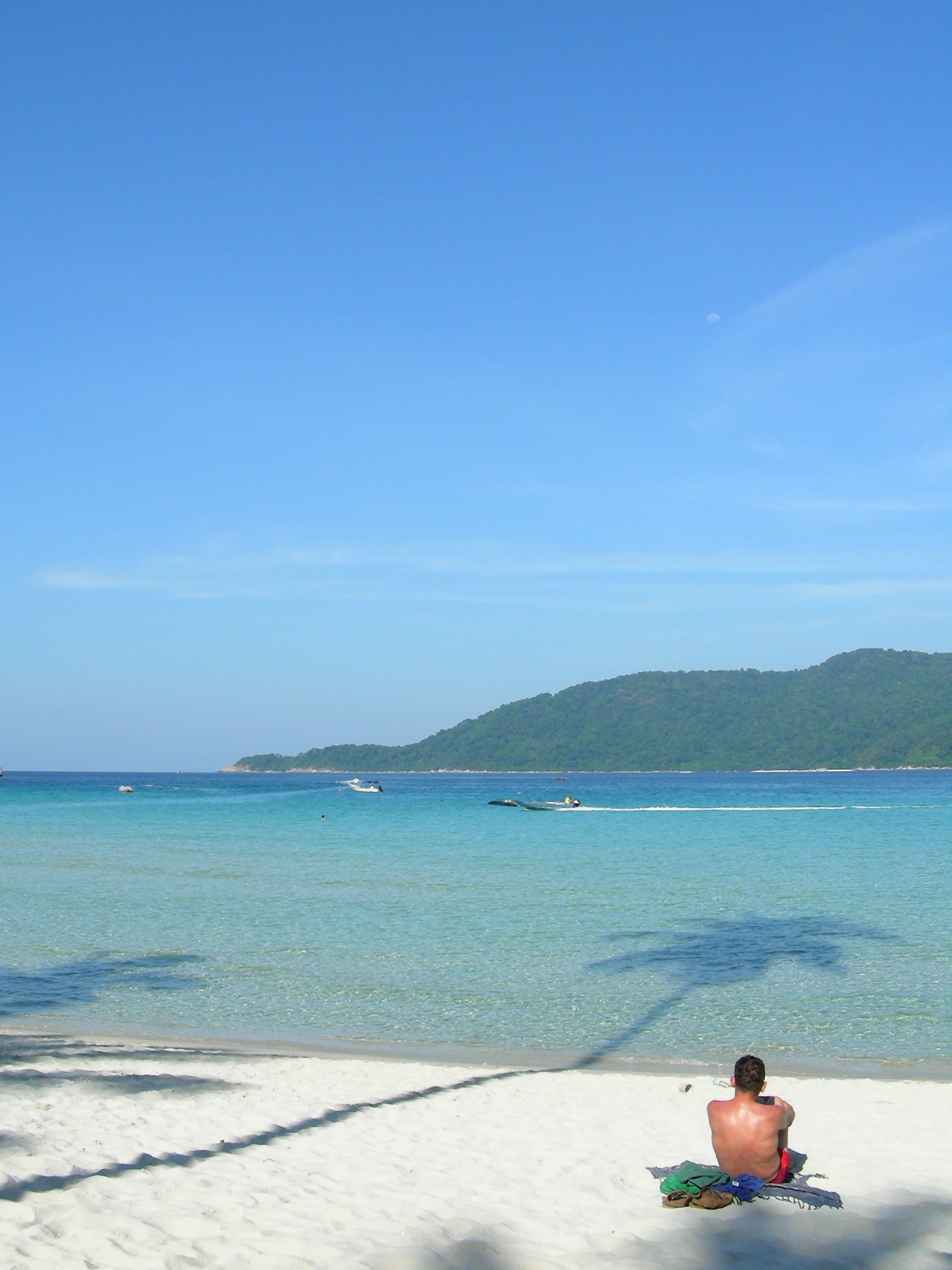
A person sits on a white sand beach facing the turquoise ocean with a distant forested island visible under a clear blue sky; shadows of palm trees are cast across the foreground sand.
A person relaxes on the white sand beach of the Perhentian Islands, overlooking turquoise tropical waters.

Perhentian Islands history and protected-area timeline

The name 'Perhentian' means 'stopping point' in Malay, and for centuries the islands served precisely that role for regional mariners. Long before modern settlement or tourism, traders passing between Bangkok and the Malay Peninsula, as well as salt ships running between Singgora and Kuala Terengganu, used the islands as a sheltered anchorage. This practical role is preserved in the name itself, and during the British colonial period the same function was reflected in English-language maps that labelled the group 'The Station Islands'.

For most of their recorded history the islands were sparsely populated, supporting small fishing communities rather than large settlements. In the 1970s, Pulau Perhentian became one of the landing points for Vietnamese boat people fleeing across the South China Sea. A major turning point came in 1994, when the islands were gazetted as a marine park by Malaysia's Department of Fisheries, prohibiting fishing within roughly two nautical miles of the shore to protect reef ecosystems.

From the late 20th century onward, the Perhentian Islands transitioned into a nature tourism destination, with visitors drawn by beaches, reefs, and clear water. The arrival of dive operations, resorts, and a steady flow of speedboat passengers from Kuala Besut reshaped the local economy without erasing the older fishing presence. The Department of Fisheries also established a turtle hatchery on the islands to support green and hawksbill sea turtle populations, marking a new chapter in the islands' conservation history.

Perhentian Islands landscape and geographic character

The Perhentian Islands are a low-lying tropical archipelago, with their highest point reaching approximately 344 meters and a combined land area of roughly 16 square kilometers spread across nine islands. The dramatic element of the landscape is not altitude but contrast: white coral sand beaches, clear shallow water over reef flats, and a backdrop of forested interior hills intersected by jungle trails.
A wide shot of a tropical island with a lush green, forested mountain rising above a shallow, turquoise bay with a long pier extending into the water.
A view across the turquoise waters towards Perhentian Kecil, showing the coastal landscape and a jetty.

Perhentian Islands ecosystems, habitats, and plant life

The natural environment of the Perhentian Islands is dominated by marine and coastal systems. Coral reefs fringe much of the two main islands, supporting dense reef fish communities, invertebrate life, and the occasional larger visitor such as reef sharks and rays. Above the shoreline, lowland tropical forest covers most of the interior of Perhentian Besar and Perhentian Kecil, with the islands' isolated position supporting communities of monitor lizards, geckos, and other tropical fauna.
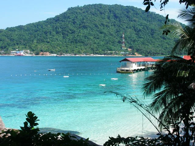
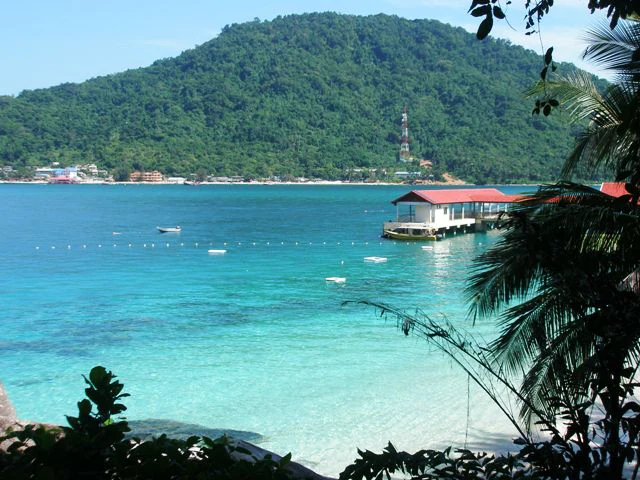
A view from a forested shoreline looking across a clear turquoise bay toward a lush green island with a pier and a communication tower visible on the hillside.
A view across the turquoise waters of the Perhentian Islands toward the forested hills of Perhentian Kecil.

Perhentian Islands wildlife and species highlights

Reef life is the wildlife showpiece of the Perhentian Islands. Snorkelers and divers regularly encounter clownfish, cuttlefish, blue-spotted rays, and blacktip reef sharks, as well as a wider range of reef fish and invertebrates across the islands' many dive sites. Sea turtles are an especially important presence, with both green and hawksbill turtles nesting on the islands' beaches, supported by a turtle hatchery run by the Department of Fisheries.

Perhentian Islands conservation status and protection priorities

The defining conservation framework of the Perhentian Islands is their 1994 marine park designation, which prohibits fishing within roughly two nautical miles of the shore. This zoning protects reef ecosystems and the broader marine food web on which the islands' tourism and turtle populations depend. Sea turtle conservation is a central theme, with hatchery operations targeting declining green and hawksbill populations, though egg poaching from beaches remains an ongoing pressure. The combination of protected marine waters, limited infrastructure, and active species-specific conservation work gives the Perhentians a meaningful role within Malaysia's coastal conservation landscape.

Perhentian Islands cultural meaning and human context

The Perhentian Islands carry a maritime cultural identity shaped by centuries of use as a trade waypoint between mainland Southeast Asia, the Malay Peninsula, and points further afield. This historical role is embedded in the islands' very name, which reflects their function as a place of rest for sea travelers rather than any specific cultural landmark. Today, the resident population reflects the broader linguistic mix of Besut District, with Kelantan-Pattani Malay, Terengganu Malay, and standard Malaysian Malay all in use alongside widely spoken English in tourism contexts. The islands' small fishing communities continue to coexist with a seasonal tide of visitors who come primarily for the marine environment rather than for built cultural heritage.

Top sights and standout views in Perhentian Islands

The Perhentian Islands' strongest highlights all relate to water and reef: consistently clear tropical seas, fringing coral reefs accessible directly from the beach, and reliable encounters with reef sharks, rays, and reef fish. The archipelago's marine park status adds an extra layer of protection to this reef system, while the sea turtle hatchery gives the islands a tangible conservation story tied directly to their beaches and waters.

Best time to visit Perhentian Islands

The character of a visit to the Perhentian Islands is shaped strongly by the monsoon cycle. The peak season, when waters are calm and conditions favor diving and snorkeling, falls outside the heavy northeast monsoon months. Between roughly November and February, frequent storms and rough seas lead most resorts and ferry services to close for the season, and the islands essentially shut down for conventional tourism.

During the open season, temperatures stay steady around 30 degrees Celsius, with frequent brief thunderstorms providing the main interruption to otherwise calm and sunny conditions. For visitors interested in the full range of dive sites, sea turtle activity, and the widest range of operating facilities, the dry, calmer months on either side of the monsoon window offer the most rewarding conditions.

Monthly climate preview

Long-term temperature averages and monthly precipitation records across representative coordinate sampling

Perhentian Islands Climate Normals and Annual Weather Patterns

Representative coordinate records show measured annual temperature ranges and monthly precipitation variations from 1991 through 2020. Examining the complete twelve-month climatology dataset clarifies long-term baseline conditions across the protected terrain.
Annual mean27 °C
26 °C29 °C
Jan26°
Feb26°
Mar27°
Apr28°
May29°
Jun28°
Jul28°
Aug28°
Sep28°
Oct27°
Nov27°
Dec26°
Warmest month
May

28.6 °C

Coolest month
January

25.6 °C

Wettest month
November

17.3 mm/day

Driest month
February

2.6 mm/day

Park location guide

Geography guide, regional context, and park location map for Perhentian Islands

Perhentian Islands park geography, regions, and map view in Malaysia

Understand where Perhentian Islands sits in Malaysia through a broader geographic reading of the surrounding landscape, nearby location context, and its mapped position within the national park landscape.

How Perhentian Islands fits into Malaysia

Malaysia is a federal constitutional monarchy located in Southeast Asia. The country consists of 13 states and three federal territories, divided by the South China Sea into Peninsular Malaysia on the Indochinese Peninsula and East Malaysia on the island of Borneo. With a population of over 34 million, it achieved independence from Britain in 1957 and became a modern federation in 1963. The country is recognized for its multicultural population, tropical climate, and significant economic role in the region.

Wider geography shaping Perhentian Islands in Malaysia

Malaysia occupies a strategic position in Southeast Asia, split by the South China Sea into two distinct regions. Peninsular Malaysia lies on the Indochinese Peninsula, sharing a land border with Thailand to the north and maritime borders with Singapore, Vietnam, and Indonesia. East Malaysia occupies the northern portion of Borneo, sharing land borders with Brunei and Indonesia, and maritime borders with the Philippines and Vietnam. The country's terrain includes coastal plains, mountain ranges such as the Titiwangsa in the peninsula, and extensive tropical rainforests.

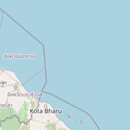
Map view of Perhentian Islands

Use this park location map to pinpoint Perhentian Islands in Malaysia, understand its exact geographic position, and read its mapped placement within the surrounding landscape more clearly.

Pigeon | © OpenStreetMap contributors

Location context for Perhentian Islands

Terengganu

Visualizing tropical coral reefs, white sand beaches, and forested interior hills across the archipelago.

Perhentian Islands Photos and Scenery: Exploring Marine Park Landscapes

Visual documentation captures the marine park environment, featuring clear tropical waters, fringing coral reefs, and dense jungle hills across nine islands. Examining protected area imagery provides a clear reference for understanding local island geography, coastal habitats, and conservation landscapes.

A person sits on a white sand beach facing the turquoise ocean with a distant forested island visible under a clear blue sky; shadows of palm trees are cast across the foreground sand.

A white motorboat with a blue canopy floating in bright turquoise shallow water next to a pier structure.

A wide shot of a tropical island with a lush green, forested mountain rising above a shallow, turquoise bay with a long pier extending into the water.

A view from a forested shoreline looking across a clear turquoise bay toward a lush green island with a pier and a communication tower visible on the hillside.

Park atlas

Discover related marine reserves and coastal protected landscapes across the surrounding region

Explore Protected Areas and Parks Near Perhentian Islands

Browse nearby national parks and protected areas to compare regional marine ecosystems beyond the Perhentian Islands. Connecting with adjacent coastal reserves expands your understanding of tropical island geography and conservation landscapes.
A watercolor painting showing a stylized, panoramic view of layered purple and pink mountains in the background with soft green forests and grassy plains in the foreground.
Marine protected areaTerengganu
About 22 km away#1 closest

Southeast

Lang Tengah Island Marine Protected Area: Geography, Reefs, and Island Terrain

A tranquil protected landscape in the Terengganu archipelago

Lang Tengah Island represents a significant marine protected area defined by its dense forested interior and surrounding coral reef ecosystems. Located within the Terengganu marine region, the island offers a unique study of protected coastal geography, seasonal turtle nesting grounds, and undisturbed tropical marine environments separated from more developed nearby archipelagos.

Area
1.3 km²
Relief
Lowland
Climate
Tropical
Access
Moderate access
A watercolor illustration of a wooden pier extending into calm wetland waters, with lush green shorelines and trees on both sides.
State or regional parkTerengganu
About 27 km away#2 closest

South

Setiu Wetlands State Park: Geography and Protected Area Atlas of Terengganu

Coastal lagoons, mangrove forests, and riverine ecosystems

Encompassing the largest natural wetland on Malaysia's east coast, Setiu Wetlands State Park serves as a critical protected landscape where sea, sand, and forest meet. This atlas entry details the park's 23,000 hectare expanse, highlighting the complex hydrological network of lagoons and river basins that support diverse habitats, including peat swamps and seagrass beds.

Area
230 km²
Established
2018
Relief
Lowland
Climate
Tropical
A watercolor painting of a tropical island coastline with palm trees, green vegetation, rocks in the foreground, and distant purple mountains under a soft light.
Marine protected areaTerengganu
About 35 km away#3 closest

Southeast

Redang Island Marine Protected Area: Coastal Terrain and Reef Ecosystems

Geographic atlas of the Terengganu island archipelago

Redang Island is a prominent marine protected area within the South China Sea, characterized by its forested interior, sheltered bays like Teluk Dalam, and expansive coral reef systems. As a key ecological site off the Terengganu coast, the island provides a unique study in island geography and marine conservation, offering detailed insights into the protected reef environments and coastal morphology of Peninsular Malaysia.

Area
24.2 km²
Relief
Upland
Climate
Tropical
Access
Moderate access
A soft-toned watercolor painting of a tropical island beach with a natural rock arch formation and palm trees.
Protected areaTerengganu
About 97 km away#4 closest

Southeast

Kapas Island: A Detailed Geographic Overview of the Protected Terengganu Coastal Landscape

Topography, Marine Protection Zones, and Island Geography

Kapas Island offers a focused look at the intersection of coastal geography and conservation management. This small archipelago features a tropical jungle core and protected sandy perimeters, providing a clear map of local reef health and coastal biodiversity in the Terengganu region of Malaysia.

Area
1.5 km²
Relief
Lowland
Climate
Tropical
Access
Easy access
National parkNarathiwat Province
About 136 km away#5 closest

Northwest

Budo, Su-ngai Padi National Park: Protected Tropical Rainforest Geography

Explore mapped boundaries and mountain landscapes in Southern Thailand.

Budo, Su-ngai Padi National Park is a critical protected area safeguarding one of Thailand's last significant tracts of intact tropical rainforest. Situated within the rugged Budo mountain range of Narathiwat Province, its landscape is defined by dense evergreen forests, steep terrain, and numerous waterfalls. This national park offers substantial geographic context for understanding conservation landscapes and regional terrain in peninsular Thailand, serving as a valuable addition to any atlas exploration.

Area
341 km²
Established
1999
IUCN
II
Relief
Mountain
National parkPahang
About 138 km away#6 closest

South

Taman Negara National Park: Pahang Protected Area with Mapped Boundaries for Geographic Discovery

Explore the unique landscape context within Pahang, Malaysia.

Delve into Taman Negara National Park, a significant protected area situated in Pahang, Malaysia. This detailed view highlights the park's mapped boundaries and its contribution to the regional geography. Understand the protected landscape and its place within the natural terrain of Peninsular Malaysia, essential for atlas-based geographic exploration.

Area
4,343 km²
Established
1938
IUCN
II
Relief
Mixed relief
A watercolor painting showing a quiet lakeside scene with dense green forests in the background and soft, purplish mountains rising behind them.
State or regional parkPerak
About 159 km away#7 closest

West

Belum-Temengor: Ancient Rainforest Complex and Protected Landscape Geography in Perak

Mapping the forest ridges and lake archipelago of the northern Malay Peninsula

Spanning over 130 million years of ecological history, Belum-Temengor represents a massive, continuous block of tropical rainforest. The terrain transitions from high-altitude hill forests in the north to the flooded valleys and forested islands of Tasik Temengor. This complex serves as a vital water catchment and a sanctuary for diverse flora and fauna within the broader mountainous geography of the Perak region.

Area
1,175 km²
Established
2007
Relief
Mountain
Climate
Tropical
Protected areaTerengganu
About 162 km away#8 closest

Southeast

Tenggol Island: A Geographic Overview of Terengganu's Protected Tropical Marine Landscape

Mapping reefs, forest interior, and regional maritime terrain

Tenggol Island stands as a distinct protected area off the coast of Terengganu, defined by its sharp 272-meter forested peak and complex underwater topography. This overview provides data on its coastal bays, rocky points, and fringing reef zones, offering a clear understanding of the island's unique position within the East Coast of Peninsular Malaysia's marine geography.

Area
2.62 km²
Relief
Upland
Climate
Tropical
Access
Moderate access

Common questions about visiting, size, designation, and location context for Perhentian Islands

Perhentian Islands FAQs for park facts, access, geography, and protected area context

Find quick answers about Perhentian Islands, including protected-area facts, park geography, trail and visitor context, and how the park fits into its surrounding country and regional landscape.
MoriAtlas Explorer

Continue Your Protected Areas Search Across the Global Atlas

Deepen your exploration by continuing the structured search for national parks and protected areas worldwide. Utilize the comprehensive filtering capabilities to compare different conservation landscapes and refine your understanding of global park geography. Discover more about the distribution and characteristics of protected natural areas.

Global natural geography