Reservoirs
West Tank
1,678 m

A structured mapping of terrain characteristics, regional placement, and natural landscape data.
Examine the physical geography of Petrified Forest National Park, a protected area spanning 895.94 square kilometers across Navajo and Apache counties in Arizona. This profile details the park's elevation range, stretching from 1630 to 1900 meters, and its diverse topography, which includes mesas, cliffs, and desert landscapes.
Related tags
Ancient petrified forests and colorful badlands of the American Southwest
Petrified Forest National Park is a remarkable protected area in northeastern Arizona that preserves one of the world's most spectacular concentrations of petrified wood along with extensive colorful badlands formations. The park encompasses approximately 346 square miles of semi-desert shrub steppe and highly eroded terrain within the Colorado Plateau region. Its name derives from the vast deposits of fossilized trees that lived during the Late Triassic Epoch roughly 225 million years ago, when this area was near the equator on the southwestern edge of the supercontinent Pangaea. The park straddles the boundary between Apache County and Navajo County, with its northern reaches extending into the famous Painted Desert. Established as a national monument in 1906 and elevated to national park status in 1962, the park protects not only its world-famous fossil forests but also significant archaeological sites representing thousands of years of human habitation and one of the most diverse Late Triassic fossil assemblages on Earth.
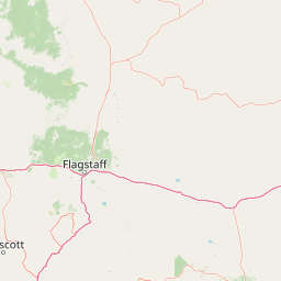
Regional mapping across Navajo and Apache counties in Arizona
Interactive perimeter geometry and calculated regional measurements
Upland elevation summary and recorded natural features across the terrain
Reservoirs
1,678 m
Rivers
Streams
Cliffs
1,745 m
Reservoirs
1,638 m
Reservoirs
1,674 m
Arid upland relief, sparse forest cover, and diverse habitat types across the terrain
Hills · Valleys · Plateau · Cliffs · Canyon · Forest · Woodland · Grassland · Steppe · Wetland · Rivers · Dunes · Desert
Grassland · Steppe · Shrubland · Wetland · Riverine habitat · Dune habitat · Desert habitat · Montane forest · Temperate coniferous forest
Trace mapped park geography and compare unique protected landscapes across the region surrounding Petrified Forest National Park.

Southwest

Exploring the vertical ecosystem gradients in Central Arizona
Spanning from arid Sonoran basins to the towering Mogollon Rim, Tonto National Forest offers a unique study in vertical geography and protected land management. This expansive territory provides a vital map of Southwest life zones, encompassing reservoir systems, rugged river canyons, and critical wilderness habitat that define the environmental identity of the region.

Southeast
Mapped terrain, forest boundaries, and regional wilderness character
Gila National Forest stands as a critical protected landscape in New Mexico, encompassing immense mountain ranges, narrow river gorges, and extensive backcountry basins. This atlas entry details the forest's topographic transition from high-altitude ponderosa stands to desert lowlands, highlighting its status as the foundational site for the global wilderness movement and a stronghold for regional ecological diversity.
Southwest
Mapping the ecological transition from desert canyon to forest ridge
Mazatzal Wilderness stands as an essential protected area in central Arizona, covering vast tracts of the Tonto and Coconino National Forests. The landscape is defined by the stark vertical contrast between the low-lying Verde River corridor and the high-elevation forests of the Mazatzal Mountains. This expansive wilderness remains a key study in regional topography and ecological zonation for those exploring the rugged backcountry of the southwestern United States.
West
Arizona high-desert wilderness and canyon-edge geography
Located southeast of Sedona, Munds Mountain Wilderness encompasses roughly 18,150 acres of dramatic sandstone cliffs and elevated plateaus. This area serves as a key site for observing the convergence of pinyon-juniper woodlands with iconic desert rock formations, providing a clear window into the rugged topography of central Arizona.
West
High-altitude volcanic terrain and alpine ecosystems
Kachina Peaks Wilderness is a protected area in northern Arizona centered on the San Francisco Peaks. This geography includes the state's highest elevation at Humphreys Peak and a rare volcanic caldera known as the Inner Basin. The terrain transitions from dense mountain forests into an Arctic-Alpine zone, offering a distinct landscape for analyzing mountain evolution and high-elevation ecological patterns.
West
Canyon landscapes and high mesa terrain in Arizona
Red Rock-Secret Mountain Wilderness serves as a significant protected block near Sedona, featuring a complex network of slot canyons, natural arches, and sandstone pinnacles. This wilderness area preserves the ecological transition from the high-elevation forested rim down into warmer, arid canyon bottoms, offering a deep look at the geology of the Colorado Plateau edge.
West
Regional geography and protected terrain map of the Bradshaw Mountains
Spanning over one million acres, Prescott National Forest represents a defining outdoor landscape in Arizona. The terrain transitions from high desert chaparral to dense ponderosa pine forests, featuring eight distinct wilderness areas, rugged canyon systems, and essential watershed corridors that shape the regional ecology near Prescott.

Northwest
High-elevation forest terrain bordering the Grand Canyon
Spanning over 1.6 million acres in Arizona, Kaibab National Forest is characterized by its split geographic configuration, with distinct sections flanking the North and South rims of the Grand Canyon. The terrain ranges from the high-altitude Kaibab Plateau to volcanic uplands near Williams, encompassing four designated wilderness areas and varied forest ecosystems that provide a critical buffer for the surrounding canyon country.
Delve deeper into the specific geographic attributes and mapped boundaries of Petrified Forest National Park. Understanding this national park's place within Navajo County and its unique natural terrain provides essential context for anyone exploring the atlas of protected lands and regional geography.