
Mori Atlas logo
Marine protected areaPiopiotahi (Milford Sound) Marine Reserve

A detailed look at the layered fiord oceanography and protected underwater terrain in Fiordland.

Piopiotahi (Milford Sound) Marine Reserve: Exploring Mapped Protected Landscapes and Marine Geography

Piopiotahi (Milford Sound) Marine Reserve encompasses 690 hectares of deep glacially carved fiord within the broader Fiordland region of New Zealand. This protected area is defined by a unique freshwater cap that creates distinct depth zones, supporting a remarkable concentration of black coral, soft corals, and temperate marine species along its steep rock walls. The reserve serves as a crucial scientific reference point, tracing the transition from sheltered inner fiord to the exposed coastal waters near Dale Point.

marine reservefiordFiordlandSouth Island New Zealandblack coralmarine wildlife
A colorful digital illustration featuring tall, steep mountains reflecting in calm, tranquil water with lush green trees in the foreground.

Piopiotahi (Milford Sound) Marine Reserve

Marine protected area

Park overview

Structured park overview, official facts, and landscape profile for Piopiotahi (Milford Sound) Marine Reserve

Piopiotahi (Milford Sound) Marine Reserve park facts, protected area profile, and essential visitor context

Review the core facts for Piopiotahi (Milford Sound) Marine Reserve, including designation, size, terrain, visitor scale, habitats, and operating context in one park-focused overview.

About Piopiotahi (Milford Sound) Marine Reserve

Piopiotahi (Milford Sound) Marine Reserve is a marine protected area in New Zealand's Fiordland region, covering 690 hectares of the northern half of Milford Sound. The reserve stretches about 16 kilometres from the Milford Sound Village in the inner fiord out to Dale Point on the Tasman Sea, with fishing restrictions also applying across the southern half of the sound. Established in 1993 and administered by the Department of Conservation, it is one of the more iconic marine reserves in New Zealand, combining conservation science, cultural recognition of the Maori name, and some of the country's most visited cruise scenery.

What sets Piopiotahi apart from many other marine reserves is the unusual physical structure of a fiord environment. Milford Sound is extremely deep and narrow, with sheer forested walls that plunge into a mostly muddy basin. Heavy rainfall from the surrounding mountains runs down through the steep catchments and creates a freshwater surface layer ranging from a few centimetres to roughly ten metres thick. Below that, a calm, warm and relatively clear saltwater layer supports a rich community of sponges, corals and fish, while the deeper layers below about forty metres are darkened by tannins from vegetation and become largely inhospitable to most marine life.

The reserve's biodiversity reflects this layered structure. Delicate invertebrates including tubeworms, sea sponges, soft corals, colonial sea squirts, black coral and sea anemones encrust the very steep inner rock walls. Closer to the sea, schools of butterfly perch, reef fish and rock lobster share the water with octopus, stingrays, fur seals and bottlenose dolphins. Black coral and brittle stars are particularly associated with the fiord, while Fiordland crested penguins, little blue penguins, and other marine mammals give the area a recognisable character that extends well beyond typical temperate marine environments.

Piopiotahi is also Fiordland's most popular destination for cruises and diving excursions, and access from Te Anau via the Milford Road makes it relatively approachable despite its remote setting. While tourism is welcomed, anchoring and other activities that could damage fragile species are restricted, particularly around the black coral habitats. Scientific research requires a permit, and the reserve is part of broader Fiordland-wide efforts to prevent the spread of invasive species and to protect ecological processes that elsewhere in the world have been heavily altered. As a place where conservation, scientific study, marine protection and iconic scenery meet, Piopiotahi plays a role in New Zealand's marine conservation identity that goes well beyond its 690 hectare footprint.

Quick facts and research context for Piopiotahi (Milford Sound) Marine Reserve

Piopiotahi (Milford Sound) Marine Reserve is located in Fiordland on the South Island of New Zealand. The reserve encompasses 690 hectares across approximately 16 kilometres of the northern half of Milford Sound, from the Milford Sound Village to Dale Point. It was legally established on 25 October 1993 and is administered by the New Zealand Department of Conservation alongside partners such as the Fiordland Marine Guardians and the Ministry of Primary Industries. The reserve sits within one of New Zealand's most iconic fiord landscapes, where steep forested walls, deep basins, and a layered freshwater-and-saltwater system create conditions favourable to exceptional marine biodiversity.

Protection and recognition

Marine protected area designation and official conservation recognition records

Piopiotahi (Milford Sound) Marine Reserve Protection Status and Governance Facts

Marine reserve protection status records outline the documented management scope established for Piopiotahi (Milford Sound) Marine Reserve. Conservation facts detail official designation metrics and international recognition frameworks associated with the protected marine environment.

Protection details

Protection scope
Marine
Transboundary protection
No
Park context

Deeper park guide and search-rich context for Piopiotahi (Milford Sound) Marine Reserve

Piopiotahi (Milford Sound) Marine Reserve history, landscape, wildlife, and travel context

Explore Piopiotahi (Milford Sound) Marine Reserve through its history, landscape character, ecosystems, wildlife, conservation priorities, cultural context, and seasonal travel timing in a structured park guide built for atlas discovery and search intent.

Why Piopiotahi (Milford Sound) Marine Reserve stands out

Piopiotahi is especially known for its black coral, which thrives at unusual depths for such temperate waters, and for the layered oceanography of a classic New Zealand fiord, where a dark tannin-rich freshwater cap sits over clearer seawater and dark deep basins. The reserve is also recognised as a sanctuary for Fiordland crested penguins, New Zealand fur seals, and bottlenose dolphins in a setting framed by sheer forested cliffs and waterfalls. Combined, the marine life, the dramatic fiord scenery, and the accessibility for cruises and divers make it Fiordland's signature marine protected area.
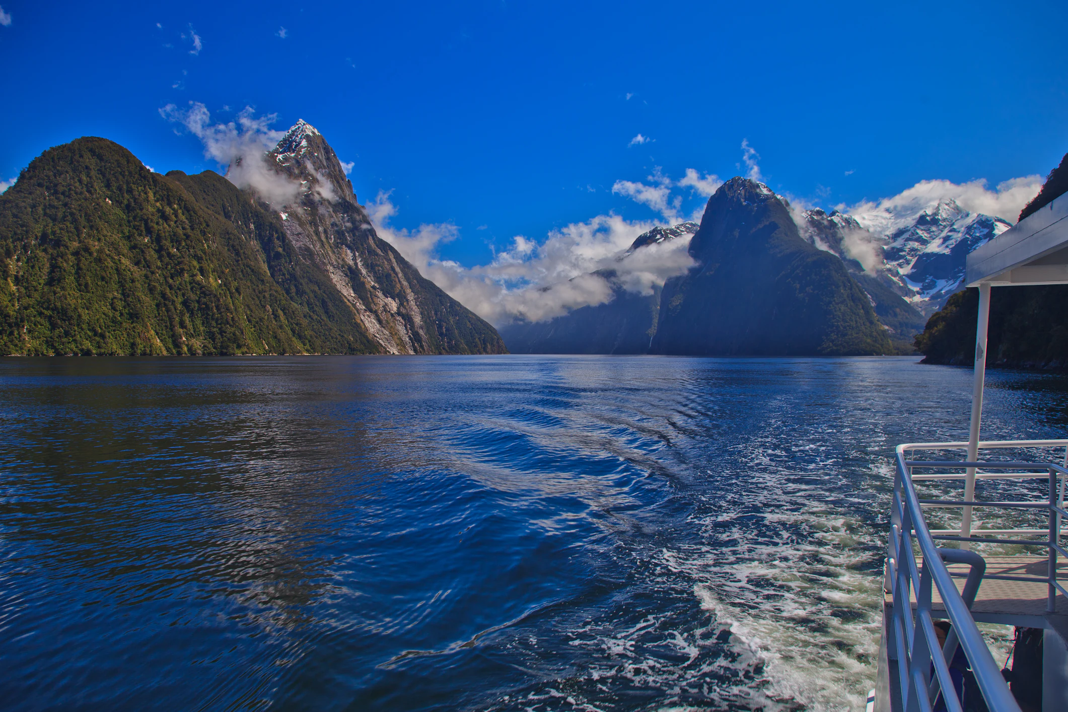
Cruise on Milford Sound
Tourist cruise boat navigating through Milford Sound

Piopiotahi (Milford Sound) Marine Reserve history and protected-area timeline

The marine reserve received legal recognition on 25 October 1993, becoming one of the protected marine areas in Fiordland's broader conservation framework. Its creation reflected a growing understanding during the late twentieth century that New Zealand's fiords were not just scenic landscapes but also unique marine environments in need of formal protection against fishing pressure, anchoring damage, and invasive species.

The Maori name Piopiotahi is itself a historical marker. It translates as 'one native thrush', referring to the piopio, a ground-feeding native bird that is now extinct. The piopio was driven to extinction by introduced predators such as rats and stoats, and the name preserves that loss within the cultural identity of the reserve. The choice of Piopiotahi as the primary name of the marine reserve reflects a broader effort by New Zealand institutions to use dual English and Maori naming for places of national significance.

In the years since establishment, the reserve has been shaped by ongoing involvement of the Department of Conservation, the Ministry of Primary Industries, the Fiordland Marine Guardians, and local iwi. These agencies work together on marine protection, biosecurity, and efforts to stop the spread of invasive seaweed into one of the country's most distinctive marine environments. Special provisions for Ngāi Tahu also allow authorised cultural harvest of pounamu by hand, along with the collection of deceased marine mammals and bones.

Piopiotahi (Milford Sound) Marine Reserve landscape and geographic character

Piopiotahi sits within Milford Sound, the most famous of the fiords in Fiordland on the South Island of New Zealand. The reserve itself is a marine landscape, but the defining scenery comes from the surrounding fiord walls: steep, forested cliffs that rise sharply from black tidal waters, with hanging valleys, waterfalls, and the heavy rain that feeds into the sound from the surrounding mountains. The combination of vertical terrain and deep water gives the sound an unusually enclosed, amphitheatre-like character.

Below the surface, the landscape is equally distinctive. Most of the sound is a deep muddy fiord basin, broken by deep reefs and shallow rock walls along the shoreline. The inner northern side features a very steep rock wall that drops quickly from near-surface waters into much deeper layers. This vertical underwater wall is what makes the reserve such an unusual place for black coral, tubeworms, sea squirts, sea anemones and other encrusting invertebrates, which require firm substrate and relatively undisturbed current conditions.

The mouth of the sound at Dale Point marks the transition into the Tasman Sea, so the reserve encompasses a gradient from sheltered inner fiord to more open coastal waters. That transition shapes both the wildlife and the oceanographic layering of the sound, creating a continuous shift between inner fiord, mid-sound reef habitats, and outer exposed coast.

Piopiotahi (Milford Sound) Marine Reserve ecosystems, habitats, and plant life

The ecological character of Piopiotahi is shaped by the unusual water structure of a temperate fiord. Rainfall from the surrounding mountains forms a dark freshwater cap that sits over the saltwater below. This freshwater layer can be as thin as a few centimetres in the inner sound or as deep as roughly ten metres, and tints the upper waters with tannins from forest run-off. Underneath, a calmer and clearer saltwater layer provides habitat for marine life to about forty metres deep, while the deepest water is darkened by tannins and supports relatively little.

Within this layered system, the habitats of the reserve include steep underwater rock walls encrusted with delicate invertebrates, deeper muddy basins, near-shore reefs, and the more open water near the Tasman Sea entrance. These habitats together support a wide biological community, ranging from sessile filter feeders clinging to vertical rock walls to mobile predators and marine mammals in the water column. The presence of black coral in particular gives the reserve an ecological identity quite distinct from typical New Zealand coastal waters.

The reserve also functions as a refuge within a wider Fiordland ecosystem that includes adjacent forest, mountain catchments, and shoreline habitats. The link between marine and terrestrial systems is unusually direct here: runoff from the forests feeds the surface layer of the sound, and the marine environment in turn influences shoreline habitats. This interconnection makes Piopiotahi an important ecological node within New Zealand's overall Fiordland landscape.

Piopiotahi (Milford Sound) Marine Reserve wildlife and species highlights

Piopiotahi is renowned for both its invertebrate and vertebrate marine life. The inner rock walls support tubeworms, sea sponges, soft corals, colonial sea squirts, black coral and sea anemones, while black coral branches are themselves habitat for brittle stars. In more open waters closer to the Tasman Sea, butterfly perch form schools alongside reef fish and rock lobster, with octopus and stingrays also present in the community.

The reserve is particularly associated with several charismatic species. Bottlenose dolphins, known in Maori as aihe, are seen in the waters of the sound and represent one of the larger marine mammals that regularly use the habitat. New Zealand fur seals, or kekono, are another important presence, while Fiordland crested penguins, known as tawaki, and little blue penguins, or kororā, are signature birdlife of the area. These penguin species are among the features that differentiate Piopiotahi from many other temperate marine reserves and give it a strong conservation identity.

Divers who visit the reserve can encounter over 100 species of fish along with stingrays, crayfish, octopus, seals and sharks. Outside the reserve boundary, fish species such as tarakihi, hāpuku (grouper), yellowtail kingfish, tuna, broadbill swordfish and blue cod are also part of the wider Milford Sound ecosystem, although only limited fishing is allowed in non-reserve waters and only a small number of rock lobsters may be taken from the sound itself.

Piopiotahi (Milford Sound) Marine Reserve conservation status and protection priorities

Piopiotahi was established in 1993 with the explicit purpose of protecting the marine environment of the northern half of Milford Sound from fishing, removal of marine life, and disturbance from anchoring. Fishing restrictions also apply to the rest of the sound, effectively giving the entire waterway strong protective status. The reserve is administered by the Department of Conservation, with the Ministry of Primary Industries, the Fiordland Marine Guardians, and other agencies playing supporting roles.

A central conservation concern is biosecurity. Invasive seaweed is one of the threats mentioned in management efforts, and agencies work to prevent its spread into a marine system that is otherwise relatively isolated. The layered oceanography of the fiord makes the reserve especially vulnerable to changes in freshwater flow, sediment input, and surface conditions, so protecting it requires attention to both marine processes and the surrounding forested catchments.

Anchoring restrictions and codes of conduct for divers reflect the reserve's role in protecting fragile species, particularly black coral colonies that can be damaged by anchors and swinging chains. Educational and scientific activities are encouraged as long as they do not disturb the environment, and any research requires a permit. Ngāi Tahu may also take pounamu under specific cultural authorisation rules, recognising both customary practice and conservation principles. Together, these measures make Piopiotahi one of the more intensively managed marine reserves in New Zealand.

Piopiotahi (Milford Sound) Marine Reserve cultural meaning and human context

The reserve's primary name, Piopiotahi, is a Maori name meaning 'one native thrush', referencing the piopio, a native bird now driven to extinction by introduced predators such as rats and stoats. The choice to use Piopiotahi as the principal name reflects New Zealand's broader recognition of Maori cultural connections with the landscape and the use of dual naming for significant natural sites. The extinction of the piopio gives the name a memorial quality, embedding the ecological history of invasive species into the cultural identity of the protected area.

Ngāi Tahu, the iwi with mana whenua over much of the South Island, have specific cultural rights within the reserve. Authorised members may collect pounamu (greenstone) by hand with minimal disturbance, and may collect deceased marine mammals and associated cultural materials such as teeth and bones. These provisions recognise customary practice while balancing conservation goals. The reserve therefore sits at the intersection of Maori cultural heritage, ecological conservation, and the more recent history of European discovery and tourism that has made Milford Sound one of New Zealand's most recognised places.

Top sights and standout views in Piopiotahi (Milford Sound) Marine Reserve

The reserve's standout features include the black coral and other deep-water invertebrates that encrust its steep inner walls, the layered fiord oceanography with a freshwater cap over clearer saltwater, and the presence of Fiordland crested penguins, New Zealand fur seals and bottlenose dolphins in a setting of dramatic forested cliffs. Its recognisable dual Maori-English naming, intensive anchoring restrictions to protect fragile species, and popularity as Fiordland's main cruise and diving destination together make it one of New Zealand's most distinctive marine protected areas despite its relatively modest 690 hectare size.

Best time to visit Piopiotahi (Milford Sound) Marine Reserve

Because Piopiotahi is a year-round marine reserve, its character changes more with weather and rainfall than with strict seasons. The Fiordland region receives very heavy rainfall, which tends to recharge the freshwater cap on the sound and to feed spectacular seasonal waterfalls. Calm, clear days are most favourable for diving, snorkelling and underwater photography, when the clearer saltwater layer below the surface is easiest to see. Wildlife viewing, including penguins, seals and dolphins, is possible throughout the year, though visibility and conditions on the water vary significantly with the weather. In all seasons, cooler water temperatures are characteristic, and visitors should expect changeable conditions that are typical of Fiordland.
Monthly climate preview

Long-term temperature ranges and precipitation patterns measured across the reserve coordinate

Piopiotahi (Milford Sound) Marine Reserve Climate and Monthly Weather Normals

Representative coordinates record annual temperature rhythms and consistent daily precipitation rates across twelve monthly observation cycles. Complete monthly records provide deeper insight into temperature variation and multi-year climate normals for the reserve.
Annual mean8 °C
3 °C12 °C
Jan12°
Feb12°
Mar11°
Apr
May
Jun
Jul
Aug
Sep
Oct
Nov
Dec10°
Warmest month
February

12.1 °C

Coolest month
July

3.5 °C

Wettest month
October

6.9 mm/day

Driest month
July

5.5 mm/day

Park location guide

Geography guide, regional context, and park location map for Piopiotahi (Milford Sound) Marine Reserve

Piopiotahi (Milford Sound) Marine Reserve park geography, regions, and map view in New Zealand

Understand where Piopiotahi (Milford Sound) Marine Reserve sits in New Zealand through a broader geographic reading of the surrounding landscape, nearby location context, and its mapped position within the national park landscape.

How Piopiotahi (Milford Sound) Marine Reserve fits into New Zealand

New Zealand is an island nation in the southwestern Pacific Ocean comprising two main islands and numerous smaller islands. Located east of Australia across the Tasman Sea, it features varied topography with the Southern Alps running along the South Island and volcanic terrain on the North Island. The country was settled by Maori people between 1280 and 1350, followed by European exploration beginning in 1642, and became a Dominion in 1907 before gaining full independence in 1947.

Wider geography shaping Piopiotahi (Milford Sound) Marine Reserve in New Zealand

New Zealand lies in the southwestern Pacific Ocean, east of Australia across the Tasman Sea. The country consists of two main islands, the North Island and South Island, plus over 600 smaller islands. The North Island features volcanic plateaus and hills while the South Island is dominated by the Southern Alps mountain range. The country has a long coastline and is surrounded by the Pacific Ocean.

Map view of Piopiotahi (Milford Sound) Marine Reserve

Use this park location map to pinpoint Piopiotahi (Milford Sound) Marine Reserve in New Zealand, understand its exact geographic position, and read its mapped placement within the surrounding landscape more clearly.

Pigeon | © OpenStreetMap contributors

Location context for Piopiotahi (Milford Sound) Marine Reserve

Fiordland
Recorded earthquake history

Review Recorded Seismic Events for Piopiotahi (Milford Sound) Marine Reserve

Examine the historical catalogue of earthquakes documented near Piopiotahi (Milford Sound) Marine Reserve. MoriAtlas provides a clear, map-based view of these seismic records, helping you understand the environmental context and historical activity patterns associated with this protected marine area.

Piopiotahi (Milford Sound) Marine Reserve Earthquake History

Catalogued events

189 events

Strongest magnitude

Magnitude 6.8

Most recent event

Sep 10, 2026

This history includes earthquakes recorded inside the park or within 50 km of its borders

Visual reference collection showcasing vertical fiord cliffs, deep habitats, and marine environments.

Piopiotahi (Milford Sound) Marine Reserve Landscape, Scenery, and Protected Wildlife Photos

Examine high-resolution imagery capturing the dramatic topography, sheer forested walls, and complex marine habitats of Piopiotahi (Milford Sound) Marine Reserve. Visual documentation reveals the steep underwater gradients, unique black coral colonies, and sheltered coastal environments defining this protected Fiordland landscape.

Cruise on Milford Sound

A bright red boat cruises on the calm, reflective waters of a fjord with steep, forested mountains on both sides.

Park atlas

Compare connected protected areas and regional marine reserves across the South Island

Parks near Piopiotahi (Milford Sound) Marine Reserve and Surrounding Fiordland Landscapes

Browsing other protected areas near Piopiotahi (Milford Sound) Marine Reserve reveals a wider network of glacial fiords, steep forested terrain, and temperate coastal habitats. Expanding the geographic comparison highlights regional conservation corridors and connected marine ecosystems across the South Island.
National parkSouthland Region
Park boundaries overlap#1 closest

South

Fiordland National Park: A Protected Landscape of Glacier-Carved Fiords and Alpine Wilderness

Explore its vast boundaries and unique temperate rainforest.

Fiordland National Park, located in the Southland Region of New Zealand, is a testament to dramatic geological forces, featuring fifteen major fiords like Milford Sound, whose Mitre Peak rises majestically from the water. This protected national park encompasses an immense wilderness of alpine terrain, ancient beech forests, and numerous waterfalls, fueled by exceptional rainfall. Its inclusion in the Te Wāhipounamu World Heritage Area underscores its global significance for biodiversity and natural landscape preservation.

Area
12,607 km²
Established
1952
IUCN
II
Visitors
500K annual
National parkOtago
20 km away#2 closest

Northeast

Mount Aspiring National Park: Glaciated Alpine Wilderness & Protected Landscape Atlas

Explore the U-shaped valleys and mapped boundaries of this iconic national park.

Mount Aspiring National Park showcases a breathtaking glacial landscape defined by steep-sided U-shaped valleys, active glaciers, and soaring alpine summits. As a designated national park within New Zealand's South Island, its protected status preserves a vast area of wilderness crucial for understanding regional geography and alpine terrain. This page provides an atlas-style exploration of its mapped boundaries and the stark, natural beauty that characterizes this significant conservation landscape in the Otago region.

Area
3,562 km²
Established
1964
IUCN
II
Relief
Mountain
Marine protected areaFiordland
31 km away#3 closest

Southwest

Hawea (Clio Rocks) Marine Reserve: Protected Marine Geography in Fiordland, New Zealand

Mapping vertical rock walls and stratified fiord water ecosystems.

Hawea (Clio Rocks) Marine Reserve is an ecologically significant marine protected area situated within the deep waters of Hāwea / Bligh Sound. The reserve is defined by its dramatic vertical rock walls, tidal current channels, and the complex water stratification that sustains diverse black coral and reef communities. It offers a unique window into the geological and marine processes that have shaped the rugged coastal landscape of New Zealand's Fiordland.

Area
4.11 km²
Established
2005
IUCN
Ia
Relief
Mountain
Marine protected areaFiordland
77 km away#4 closest

Southwest

Kahukura (Gold Arm) Marine Reserve: Marine Protected Area and Fiordland Geographic Atlas

Submerged rocky reefs and vertical rock wall landscapes

Located in the heart of New Zealand, Kahukura (Gold Arm) Marine Reserve provides a vital map of protected coastal terrain. Its unique environment features freshwater caps, tannin-stained deep water, and diverse marine topography ranging from sheltered basin ecosystems to vertical cliff structures. This marine area offers deep insight into the complex geology and conservation dynamics of the Fiordland region.

Area
4.64 km²
Established
2005
Relief
Mixed relief
Climate
Temperate
Watercolor painting of a green, hilly landscape with a winding river or inlet and pale, misty mountains in the background.
Marine protected areaFiordland
91 km away#5 closest

Southwest

Kutu Parera (Gaer Arm) Marine Reserve: Fiordland Protected Marine Landscape Atlas

Mapped marine boundaries, stratified fiord ecology, and coastal terrain analysis

Explore the structured geography of Kutu Parera (Gaer Arm) Marine Reserve, a 433-hectare protected area located within the steep, mountain-flanked fjords of New Zealand. Gain insight into its complex underwater features, including vertical rock walls, estuarine basins, and stratified water columns that define this unique marine environment within the Fiordland region.

Area
4.33 km²
Established
2005
Relief
Mixed relief
Climate
Temperate
Marine protected areaFiordland
103 km away#6 closest

Southwest

Taipari Roa (Elizabeth Island) Marine Reserve: Fiordland Marine Landscape and Atlas Map

Protected marine terrain and glacial fjord geography

Taipari Roa (Elizabeth Island) Marine Reserve is a protected marine area situated within the complex fjord network of Doubtful Sound. The reserve is characterized by steep underwater rock walls, deep kelp forests, and a unique freshwater cap that allows rare corals and glass sponges to thrive at shallow depths. This geographic overview examines the reserve's protected status and its structural role within the broader Fiordland ecosystem, highlighting the vertical aquatic terrain and surrounding islet environments.

Area
6.13 km²
Established
2005
Relief
Lowland
Climate
Temperate
Marine protected areaFiordland
128 km away#7 closest

Southwest

Moana Uta (Wet Jacket Arm) Marine Reserve: Mapped Protected Landscapes in Fiordland

Exploring unique fiord stratification and dense marine coral habitats

Located in the remote southwestern reaches of New Zealand, Moana Uta (Wet Jacket Arm) Marine Reserve preserves a complete fiord system. The area is notable for its exceptional physical conditions, including high black coral density and a distinct freshwater surface layer that sustains diverse underwater communities across steep rock walls, reefs, and deep basins.

Area
20.07 km²
Established
2005
Relief
Lowland
Climate
Temperate
National parkWest Coast
183 km away#8 closest

Northeast

Westland Tai Poutini National Park: A Protected Landscape of Glaciers and Temperate Rainforests

Explore its mapped terrain and unique glacial features in West Coast, NZ.

Westland Tai Poutini National Park represents a remarkable intersection of glacial power and lush temperate rainforests along New Zealand's West Coast. As a protected national park, it showcases dramatic alpine scenery and the unique characteristic of glaciers descending to low elevations. Users can explore the mapped boundaries and the distinct natural landscapes that define this significant protected area, offering a clear view of its place within the region's geography.

Area
1,319.8 km²
Established
1960
IUCN
II
Relief
Mountain

Common questions about visiting, size, designation, and location context for Piopiotahi (Milford Sound) Marine Reserve

Piopiotahi (Milford Sound) Marine Reserve FAQs for park facts, access, geography, and protected area context

Find quick answers about Piopiotahi (Milford Sound) Marine Reserve, including protected-area facts, park geography, trail and visitor context, and how the park fits into its surrounding country and regional landscape.
MoriAtlas Explorer

Continue Your Protected Areas Search Across the Global Atlas

Deepen your exploration by continuing the structured search for national parks and protected areas worldwide. Utilize the comprehensive filtering capabilities to compare different conservation landscapes and refine your understanding of global park geography. Discover more about the distribution and characteristics of protected natural areas.

Global natural geography