
Mori Atlas logo
Nature reservePlothener Teiche

Historic medieval fishpond networks and restored wetland terrain across eastern Thuringia

Plothener Teiche Nature Reserve: Mapped Geography and Protected Wetland Landscape in Thuringia

(Naturschutzgebiet Dreba-Plothener Teichgebiet)

Plothener Teiche represents a significant network of historic fishponds and protected wetland habitats situated in the Saale-Orla-Kreis district of Thuringia, Germany. This nature reserve features a complex mosaic of interconnected basins, including the Hausteich, framed by the characteristic terrain of the Thüringer Schiefergebirge and Obere Saale regions. The landscape reflects nearly a millennium of human-managed water systems, currently preserved to support migratory waterbirds and restored regional biodiversity.

fishpondswetland habitatwaterbirdsmigratory birdsThuringianature reserve
A flat-style digital illustration showing a calm pond with a small stilted cabin on the far shore, framed by foreground trees and dandelions in a meadow.

Plothener Teiche

Nature reserve

Park overview

Structured park overview, official facts, and landscape profile for Plothener Teiche

Plothener Teiche park facts, protected area profile, and essential visitor context

Review the core facts for Plothener Teiche, including designation, size, terrain, visitor scale, habitats, and operating context in one park-focused overview.

About Plothener Teiche

Plothener Teiche is a historic pond landscape in eastern Thuringia, in the German state of Thuringia, administered within the Saale-Orla-Kreis. It stretches across the communities of Plothen, Knau, and Dreba and lies within the broader Thüringer Schiefergebirge/Obere Saale Nature Park, giving the area a dual identity as both a protected ecological zone and a piece of regional cultural landscape.

The ponds that define the site today originated in the Middle Ages, when monastic communities constructed fishponds to meet the heavy demand for fish on fasting days. Over the centuries, smaller basins were combined into larger ones, creating a managed pond system that became a characteristic feature of the pre-industrial Thuringian countryside. The Hausteich, the largest remaining pond in the complex, reflects this long evolution of intensive pond management.

During the GDR era, the landscape suffered significant ecological damage when a large-scale pig fattening operation, the Sozialistisches Zentrum für Melioration und Kultur (SZMK Knau), used former ponds to store liquid manure from a vast livestock operation. The resulting pollution degraded water quality, killed trees, and displaced wildlife across the area. Subsequent renaturation efforts have transformed the degraded ponds back into functioning wetland habitats.

Today, Plothener Teiche functions as both a nature reserve and a regional tourism attraction. The protected designation of Dreba-Plothener Teichgebiet, in place since 1967, helps safeguard the area's biodiversity value, while its accessibility makes it a destination for anglers, cyclists, and birdwatchers. A roughly 300-year-old pile dwelling (Pfahlhaus) standing on stilts in the Hausteich serves as a small museum and the visual landmark of the entire pond district.

Quick facts and research context for Plothener Teiche

Plothener Teiche is a designated nature reserve (Naturschutzgebiet) in the Saale-Orla-Kreis district of Thuringia, classified under IUCN Category IV as a Habitat/Species Management Area. It lies within the Thüringer Schiefergebirge/Obere Saale Nature Park and spans the localities of Plothen, Knau, and Dreba.

The protected area was formally established in 1967 as the Dreba-Plothener Teichgebiet. Its ponds trace back to medieval monastic fish farming and today include the Hausteich, the largest basin in the complex. The surrounding region is popularly known as the "Land der tausend Teiche" (Land of a Thousand Ponds), a cultural and ecological landscape shaped by centuries of pond management.

Protection and recognition

Explore documented terrestrial protection metrics and official Natura 2000 listings.

Plothener Teiche Protection Status and International Recognition

Plothener Teiche maintains documented terrestrial protection status alongside verified Natura 2000 entries. Structured records capture official conservation designations and international recognition sources for this protected landscape.

International recognition

Protection details

Protection scope
Terrestrial
Transboundary protection
No
WDPA ID
162794
Park context

Deeper park guide and search-rich context for Plothener Teiche

Plothener Teiche history, landscape, wildlife, and travel context

Explore Plothener Teiche through its history, landscape character, ecosystems, wildlife, conservation priorities, cultural context, and seasonal travel timing in a structured park guide built for atlas discovery and search intent.

Why Plothener Teiche stands out

Plothener Teiche is best known as a historic fishpond landscape that combines medieval cultural heritage with restored wetland ecology. Its centuries-old pattern of small and large basins, including the Hausteich with its iconic pile dwelling, makes it a defining example of the Thuringian "Land of a Thousand Ponds" tradition. The area is also recognized as a habitat and resting site for waterbirds, including grebes, lapwings, coots, snipes, ospreys, and kites, and during migration season the famous "Starenwunder" sees thousands of starlings and other passerines gather above the ponds. The combination of monastic-origin fish culture, post-war ecological damage, and successful renaturation gives the site a distinctive identity among German nature reserves.
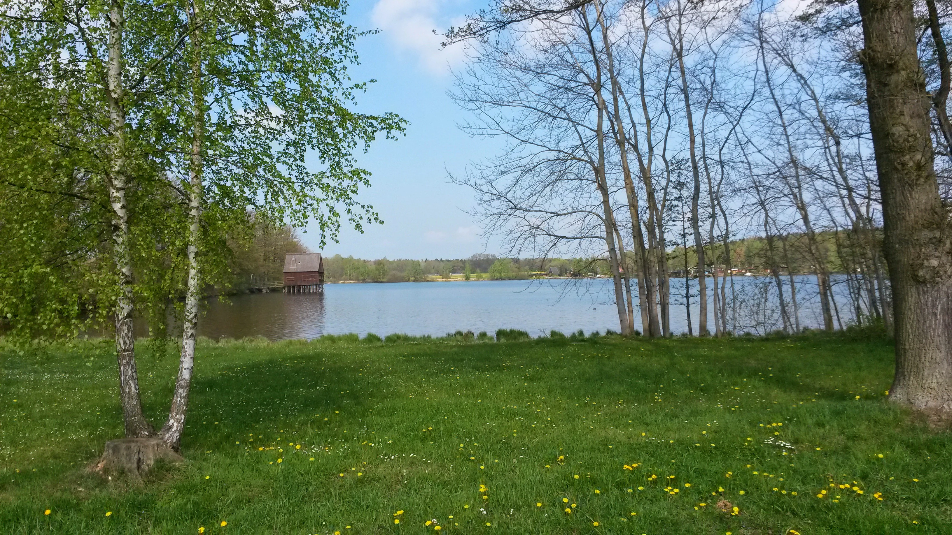
A calm lake surrounded by trees and green grass, with a small brown wooden building standing on stilts in the water on the left side.
A peaceful view of a pond in the Plothener Teiche nature reserve, featuring a small stilt house near the water's edge.

Plothener Teiche history and protected-area timeline

The pond system at Plothener Teiche traces its origins to the Middle Ages, when monastic communities built fishponds to supply fish for the many fasting days of the pre-industrial calendar. This intensive pond management gradually expanded as smaller basins were merged into larger ones, producing the characteristic pond mosaic seen today. The medieval monastic fishpond tradition evolved into a broader regional system that would eventually earn the surrounding area the nickname "Land of a Thousand Ponds."

The twentieth century brought both formal recognition and serious ecological damage. In 1967, the area was officially designated as the Naturschutzgebiet Dreba-Plothener Teichgebiet, marking its transition into a protected nature reserve. However, during the GDR period, a large centralized agricultural operation, the SZMK Knau, used ponds in the area as liquid manure storage for an industrial-scale pig fattening facility. The pollution that resulted severely damaged water quality, killed trees, and displaced local wildlife.

After reunification, renaturation efforts addressed the legacy of that agricultural pollution. The ponds were gradually restored to functioning wetland ecosystems, and a diverse plant and animal community re-established itself. Today, the Plothener Teiche area reflects both its medieval monastic origins and its more recent journey from ecological damage to restored habitat, including the continued presence of the centuries-old Pfahlhaus on the Hausteich as a tangible link to the past.

Plothener Teiche landscape and geographic character

The landscape of Plothener Teiche is defined by an extensive system of interconnected fishponds set within the gently rolling countryside of eastern Thuringia. The ponds vary widely in size and shape, reflecting centuries of merging and reshaping, with the Hausteich standing out as the largest basin in the complex at roughly 28 hectares.

Surrounding the open water are woodland patches, reed beds, marshy edges, and agricultural land, creating a diverse mosaic of habitats across the Saale-Orla-Kreis. The terrain sits within the broader Thüringer Schiefergebirge/Obere Saale Nature Park, so the pond landscape is framed by the characteristic geology of the Thuringian Slate Mountains and the upper Saale river region.

The most recognizable feature in the landscape is the roughly 300-year-old Pfahlhaus, a small wooden pile dwelling standing on stilts in the Hausteich. This structure has become the visual signature of the area and now serves as a small museum. The overall scenery combines open water, wetland margins, and forested edges, producing a tranquil rural wetland environment that feels distinct from both the surrounding farmland and the upland slate mountains.
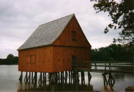
A brown timber stilt house stands on wooden pilings above the water of a pond, connected to the shore by a short wooden footbridge.
A traditional timber stilt house situated on the Hausteich in the Plothener Teiche nature reserve.

Plothener Teiche ecosystems, habitats, and plant life

Plothener Teiche supports a layered wetland ecosystem shaped by centuries of pond management and recent ecological recovery. The open pond water, fringing reed belts, marshy shorelines, and adjacent woodland create a varied habitat mosaic typical of traditional managed pond landscapes in central Germany.

The aquatic environment provides habitat for fish and invertebrates, while the reed and shoreline vegetation supports nesting and feeding waterbirds. Surrounding woodland adds structural diversity and offers refuge for passerines and other forest-associated species. The combination of managed ponds with wetlands and woodland edges is what gives the reserve its character as a working cultural landscape that also functions as a biodiversity area.

Although the broader region historically contained around 1,600 ponds within a small radius, only about 600 remain in the twenty-first century. This shrinkage makes the surviving pond network at Plothener Teiche, including the Hausteich and its neighboring basins, an increasingly important refuge for wetland biodiversity in eastern Thuringia.

Plothener Teiche wildlife and species highlights

The Plothener Teiche area is well known for its rich waterbird community, which has rebounded strongly after the pond renaturation. Resident and breeding species include grebes, lapwings, coots, snipes, ospreys, and various kites, along with a wide range of smaller songbirds that inhabit the reed beds, shorelines, and surrounding woodland.

Beyond the resident fauna, the reserve holds particular importance as a migration stopover site. Vast flocks of starlings and other migratory birds gather at the ponds during the bird migration seasons, creating the local phenomenon known as the "Starenwunder," in which thousands of birds swirl above the water before continuing their journeys.

The combination of breeding waterbirds, seasonal concentrations of migrants, and supporting woodland and wetland species makes the area a regionally significant birding site. The presence of ospreys in particular suggests that the fish stocks in the ponds have recovered sufficiently to support large predatory birds, underscoring the success of the renaturation process.

Plothener Teiche conservation status and protection priorities

Plothener Teiche has been formally protected since 1967 as the Naturschutzgebiet Dreba-Plothener Teichgebiet, classified under the IUCN framework as a Category IV Habitat/Species Management Area. This designation reflects the site's role in maintaining the pond-dependent habitats and species that define this cultural landscape.

The reserve illustrates how cultural landscapes shaped by centuries of human management can retain strong conservation value. The surviving traditional pond network within the area, part of a broader historical landscape of around 1,600 former ponds, supports wetland species and acts as a refuge for biodiversity in a region where pond density has declined sharply.

The area's conservation history is also marked by recovery. The severe ecological damage caused by the SZMK Knau intensive livestock operation during the GDR era polluted water bodies and displaced wildlife, but subsequent renaturation efforts restored functioning ecosystems and allowed plants and animals to recolonize the ponds. The reserve today demonstrates the value of long-term protection combined with active restoration of damaged wetland habitat.

Plothener Teiche cultural meaning and human context

The pond landscape around Plothener Teiche carries a strong monastic and rural cultural identity. Medieval monks built the original fishponds to supply fish for fasting days, embedding religious dietary practice into the physical shape of the land. Over time, the tradition of intensive pond management became a defining feature of Thuringian rural life, producing not only food but also a regional cultural identity expressed in the nickname "Land of a Thousand Ponds."

The centuries-old Pfahlhaus on the Hausteich is a tangible reminder of this long pond heritage. Built roughly 300 years ago on stilts over the water, it anchors the historical memory of the area and now functions as a small museum. The site's broader cultural fabric also includes its twentieth-century agricultural history, including the damaging but historically significant GDR-era livestock operations, which are now part of the area's narrative of ecological recovery.

Top sights and standout views in Plothener Teiche

The defining feature of Plothener Teiche is the Hausteich, the largest pond in the complex, crowned by its iconic 300-year-old Pfahlhaus museum standing on stilts above the water. The site offers an exceptional example of a medieval-origin fishpond landscape that has evolved across almost a thousand years of management and is now restored to ecological health.

Visitors and naturalists value the area for its rich waterbird community, its role as a major migratory stopover with the seasonal Starling spectacle, and its network of ponds embedded within the Thüringer Schiefergebirge/Obere Saale Nature Park. The combination of cultural heritage, scenic open water, woodland edges, and successful ecological recovery makes Plothener Teiche a compact but distinct wetland destination in eastern Thuringia.

Best time to visit Plothener Teiche

Plothener Teiche rewards visits across much of the year, but the pond landscape takes on different characters with the seasons. Spring and early summer bring active breeding waterbird activity along the reed beds and pond margins, when lapwings, coots, grebes, and a variety of songbirds are most visible around the Hausteich and its neighboring basins.

Autumn is particularly special, as the migratory season transforms the reserve into one of the region's notable birding experiences, including the spectacular gathering of starlings and other migrants above the ponds. Summer offers long, mild days suited to cycling between ponds and fishing outings, while quieter winter visits showcase the open water framed by the surrounding woodland. The area's recreational draws, including angling, cycling, and birdwatching, remain accessible across much of the year.


Monthly climate preview

Long term temperature averages and monthly precipitation records for Thuringia

Plothener Teiche Climate Normals and Annual Weather Patterns

Representative coordinate measurements record twelve month temperature ranges alongside steady precipitation values across the protected terrain. Analyzing complete monthly climate normals reveals long term meteorological patterns for Plothener Teiche without relying on live forecasts.
Annual mean8 °C
-2 °C18 °C
Jan-2°
Feb-1°
Mar
Apr
May12°
Jun16°
Jul18°
Aug18°
Sep13°
Oct
Nov
Dec-1°
Warmest month
July

17.8 °C

Coolest month
January

-2.4 °C

Wettest month
July

2.8 mm/day

Driest month
April

1.4 mm/day

Park location guide

Geography guide, regional context, and park location map for Plothener Teiche

Plothener Teiche park geography, regions, and map view in Germany

Understand where Plothener Teiche sits in Germany through a broader geographic reading of the surrounding landscape, nearby location context, and its mapped position within the national park landscape.

How Plothener Teiche fits into Germany

Germany is a federal republic in Western and Central Europe with a population of over 83 million across sixteen constituent states. It is Europe's largest economy by nominal GDP and a major global exporter and importer. The capital is Berlin, and the country borders Denmark, Poland, Czech Republic, Austria, Switzerland, France, Luxembourg, Belgium, and the Netherlands.

Wider geography shaping Plothener Teiche in Germany

Germany is located in Western and Central Europe, spanning 357,022 km². It borders Denmark to the north, Poland and the Czech Republic to the east, Austria and Switzerland to the south, and France, Luxembourg, Belgium, and the Netherlands to the west. The country has coastlines on the Baltic Sea and North Sea to the north, with the Alps located in the southern region.

Map view of Plothener Teiche

Use this park location map to pinpoint Plothener Teiche in Germany, understand its exact geographic position, and read its mapped placement within the surrounding landscape more clearly.

Pigeon | © OpenStreetMap contributors

Location context for Plothener Teiche

Thuringia
Recorded earthquake history

Explore the Historical Earthquake Record for Plothener Teiche

Review documented seismic activity and historical event data associated with the Plothener Teiche region. This MoriAtlas collection provides transparent access to recorded epicentre distances and magnitudes for researchers and enthusiasts examining the area.

Plothener Teiche Earthquake History

Catalogued events

9 events

Strongest magnitude

Magnitude 5.1

Most recent event

Oct 19, 2007

This history includes earthquakes recorded inside the park or within 50 km of its borders

Visualizing the historic fishpond terrain, wetland habitats, and protected nature reserve character of eastern Thuringia.

Plothener Teiche Photos and Landscape Scenery Visual Exploration

Visual records capture the interconnected fishponds, reed beds, and open waterways defining the protected wetland environment of Plothener Teiche. Studying these detailed landscape photographs reveals the unique topography, historic structures, and diverse avian habitats of the region.

A calm lake surrounded by trees and green grass, with a small brown wooden building standing on stilts in the water on the left side.

A serene view of a pond, Neuer Teich, surrounded by green trees and fields on a clear spring day.

A brown timber stilt house stands on wooden pilings above the water of a pond, connected to the shore by a short wooden footbridge.

Park atlas

Discover adjacent wetland reserves, regional nature parks, and connected protected landscapes.

Explore Protected Areas and Parks Near Plothener Teiche in Central Germany

Compare Plothener Teiche with other historic wetland reserves and regional nature parks across eastern Thuringia. Examining surrounding protected areas reveals broader patterns in regional waterbird habitats and medieval pond geography.
A horizontal watercolor illustration showing soft green hills, forest patches, and distant pale pink mountains.
Nature reserveThuringia
About 8.3 km away#1 closest

South

Kobersfelsen Nature Reserve: Silicate Cliff Geography and Protected Valley Landscapes

Geographic context for the Thuringian Slate Mountains protected area.

Kobersfelsen features a significant silicate rock outcrop rising above the Saale valley. As part of a larger Habitats Directive site, this nature reserve integrates cliffside forest with rare botanical communities. Users can examine the specific site boundaries and understand its role within the wider ecological network of the Thuringian region.

Area
0.06 km²
Established
1989
IUCN
IV
Relief
Upland
A soft watercolor painting of a rolling landscape with green hills, scattered trees, and pale, earthy foreground textures.
Nature reserveThuringia
About 12 km away#2 closest

West

Buchenberg bei Krölpa Nature Reserve: Mapped Geography and Protected Landscape Context

A restored limestone quarry habitat located in Thuringia, Germany.

Buchenberg bei Krölpa stands as a regionally significant nature reserve located east of Krölpa. Formerly a site of limestone extraction, the protected area now functions as a managed habitat, characterized by its broken, stepped terrain and slopes that host native orchid species and dry grassland vegetation within the broader Thuringian countryside.

Area
0.201 km²
Established
1996
IUCN
IV
Relief
Upland
A horizontal watercolor painting of a wooden boardwalk path cutting through a forest clearing with scattered pine trees, rendered in soft light tones.
Nature reserveThuringia
13 km away#3 closest

East

Pöllwitzer Wald Nature Reserve: Geographic Overview and Protected Area Mapping

Historic forest landscapes in the Thuringia region

Pöllwitzer Wald represents a dense, historically significant nature reserve located near the Thuringia and Saxony border. This detailed overview covers the essential geographic features, including the unique moorland basin, coniferous forest transitions, and the remnants of early modern log floating infrastructure that shaped the regional topography.

Area
9.62 km²
Relief
Upland
Climate
Temperate
Access
Easy access
A soft watercolor painting showing a pond landscape with rolling hills in the background, green trees in the midground, and tall grasses along the water edge.
Nature reserveSachsen
19 km away#4 closest

Southeast

Großer Weidenteich Nature Reserve: Mapping the Biodiversity of the Saxon Vogtland

A vital protected landscape shaped by traditional grazing management

Großer Weidenteich acts as a crucial refuge for diverse species, including nearly 700 butterfly varieties and numerous breeding bird populations. The reserve's landscape is characterized by a mix of wetlands, meadows, and shrubby margins that rely on continuous sheep grazing for structural maintenance. This area provides a clear perspective on how small-scale water bodies and varied vegetation patches contribute to the health of the broader Saxon regional ecosystem.

Area
3.349 km²
Established
1994
IUCN
IV
Protected landscapeBavaria
20 km away#5 closest

South

Naturpark Frankenwald: Geographic Profile of Bavaria's Forested Protected Landscape

A vast, interconnected upland spanning the Bavaria and Thuringia border

Naturpark Frankenwald functions as a large-scale managed nature preserve that integrates cultural heritage with ecological conservation. The terrain consists of gentle mountainous ridges, narrow river valleys, and extensive mixed forests that form a continuous landscape belt across northern Bavaria. This profile provides an overview of the regional geography, boundary extent, and the natural features that define this significant central German upland area.

Area
1,023 km²
Established
1973
Relief
Upland
Climate
Temperate
A horizontal watercolor illustration showing green rolling hills, distant light green ridges, and sparse trees against a white background.
Nature reserveThuringia
About 24 km away#6 closest

Northwest

Spitzenberg-Schießplatz Rothenstein-Borntal Nature Reserve and Saale Valley Geography

Protected forest and grassland terrain in Thuringia

Spitzenberg-Schießplatz Rothenstein-Borntal is a protected nature reserve in Thuringia, covering hundreds of hectares of forest slopes, plateaus, and open clearings. This reserve is recognized for its unusual structural diversity, ranging from closed valley woodland to sun-exposed semi-dry grassland, providing essential habitat within the middle Saale valley region.

Area
5.542 km²
Established
1961
IUCN
IV
Nature reserveThuringia
About 27 km away#7 closest

Northwest

Leutratal und Cospoth Nature Reserve: Mapping Calcareous Grasslands in Thuringia

A study of limestone slopes and orchid-rich habitats in central Germany

Leutratal und Cospoth serves as a prime example of protected Muschelkalk landscape in Thuringia. This reserve captures the complex transition between open grasslands, scrub, and beech forests within the middle Saale valley, offering deep insights into the region's unique geological and botanical heritage.

Area
5.829 km²
Established
1961
IUCN
IV
Relief
Upland
Protected areaThuringia
About 28 km away#8 closest

East

Wälder um Greiz und Werdau: Protected Landscape and Regional Woodland Atlas for Thuringia

Continuous forest terrain on the Thuringia and Saxony border

The protected landscape of Wälder um Greiz und Werdau covers rolling hills and valleys between the Pleiße and Weiße Elster rivers. Use this atlas resource to understand the park's mapped boundaries, forest pond distribution, and its role as a green corridor between regional townscapes.

Area
62 km²
Established
1961
Relief
Upland
Climate
Temperate

Common questions about visiting, size, designation, and location context for Plothener Teiche

Plothener Teiche FAQs for park facts, access, geography, and protected area context

Find quick answers about Plothener Teiche, including protected-area facts, park geography, trail and visitor context, and how the park fits into its surrounding country and regional landscape.
MoriAtlas Explorer

Continue Your Protected Areas Search Across the Global Atlas

Deepen your exploration by continuing the structured search for national parks and protected areas worldwide. Utilize the comprehensive filtering capabilities to compare different conservation landscapes and refine your understanding of global park geography. Discover more about the distribution and characteristics of protected natural areas.

Global natural geography