
Mori Atlas logo
Marine protected areaPōhatu Marine Reserve

Mapping the volcanic cliffs, kelp forests, and intertidal zones of this Canterbury marine refuge

Pōhatu Marine Reserve: A Protected Marine Landscape within the Canterbury Coastal Region

Pōhatu Marine Reserve encompasses a 215 hectare no-take area on the southern coast of Banks Peninsula. This protected landscape is defined by its deep volcanic crater setting, high coastal cliffs, and expansive kelp forests that provide essential habitats for marine mammals and reef fish. Beyond the underwater topography, the site serves as a vital conservation refuge for little blue penguins and yellow-eyed penguins nesting along the adjacent rocky shoreline.

marine reserveno-take zoneBanks Peninsulacoastal cliffskelp forestrocky reef
A flat-style digital illustration of a coastal landscape with a prominent sea arch in a cliff face, surrounding green hills, and light blue water under a sunset sky.

Pōhatu Marine Reserve

Marine protected area

Park overview

Structured park overview, official facts, and landscape profile for Pōhatu Marine Reserve

Pōhatu Marine Reserve park facts, protected area profile, and essential visitor context

Review the core facts for Pōhatu Marine Reserve, including designation, size, terrain, visitor scale, habitats, and operating context in one park-focused overview.

About Pōhatu Marine Reserve

Pōhatu Marine Reserve is a small but ecologically dense marine protected area on the southern edge of Akaroa Harbour, on the volcanic Banks Peninsula of New Zealand. Despite covering only around 215 hectares, it concentrates a remarkable variety of coastal habitats within a single bay, including high cliffs, surge-exposed rocky headlands, sheltered tidal reefs, kelp forests, and small sandy beaches. This landscape diversity, combined with the bay's position on a nutrient-rich stretch of the Canterbury coast, gives the reserve an outsized ecological significance for its size.

The reserve encompasses the full extent of Pōhatu / Flea Bay and extends along the coast between Damons Bay (Mangarohotu) and Strong Bay (Ōpatoti). Its waters are typically sheltered from prevailing winds and swells by cliff walls several hundred metres high, though southerly weather can drive strong conditions inside the bay. Sandy substrates, kelp-covered reefs, and clear visibility underpin a marine community that includes reef fish, shellfish, and visiting marine mammals. The presence of Hector's dolphins, in particular, links the reserve to broader conservation efforts for one of New Zealand's most endangered coastal species.

On land, the reserve is closely tied to the surrounding private farmland and to the Flea Bay penguin colony at the head of the bay. The Helps family, long-time landowners, have run predator control and population monitoring for kororā and hoiho, supported by the Department of Conservation and volunteers. Their work has helped the breeding penguin population grow substantially since the reserve's creation, and it has shaped the surrounding bay into an established eco-tourism destination that draws visitors interested in both marine and seabird life.

As the first marine reserve on the east coast of the South Island, Pōhatu also occupies an important place in New Zealand's marine protection history. It emerged from a contested multi-year process involving recreational fishers, commercial interests, and local Māori kaitiaki, and its eventual establishment helped shift the regional conversation about how coastal ecosystems around Banks Peninsula should be safeguarded.

Quick facts and research context for Pōhatu Marine Reserve

Pōhatu Marine Reserve lies on Banks Peninsula in Canterbury, on the eastern South Island of New Zealand, around 15 kilometres south of Akaroa. The reserve covers approximately 215 hectares of coastal water centred on Pōhatu / Flea Bay, extending along the shore between Ounu-hau Point and Redcliffe Point.

It was formally established in 1999, becoming the first marine reserve on the east coast of the South Island. The reserve is administered by the New Zealand Department of Conservation and operates as a strict no-take zone for the general public, with limited customary harvesting rights retained. Its setting combines high volcanic cliffs, kelp-covered reefs, and sandy beach habitat, and it is closely linked to a thriving nearby penguin colony managed by the private landowners at the head of the bay.

Protection and recognition

Examine the documented marine protection scope and official designation records for Pōhatu Marine Reserve.

Pōhatu Marine Reserve Protection Status and Official International Recognition Facts

Marine protection status records for Pōhatu Marine Reserve outline the documented conservation scope and management frameworks. Official designation data provides clear context for evaluating regional marine reserves and protected areas.

Protection details

Protection scope
Marine
Transboundary protection
No
Park context

Deeper park guide and search-rich context for Pōhatu Marine Reserve

Pōhatu Marine Reserve history, landscape, wildlife, and travel context

Explore Pōhatu Marine Reserve through its history, landscape character, ecosystems, wildlife, conservation priorities, cultural context, and seasonal travel timing in a structured park guide built for atlas discovery and search intent.

Why Pōhatu Marine Reserve stands out

Pōhatu Marine Reserve is best known for its combination of a small, sheltered marine reserve and the largest penguin colony on Banks Peninsula. The reserve sits inside the volcanic crater landscape of Banks Peninsula, where high cliffs and reef systems create a compact but ecologically rich coastal environment. Its waters are a recognised habitat for Hector's dolphins, one of the rarest small cetaceans in the world, alongside regular visits from dusky dolphins and New Zealand fur seals. Onshore, the adjoining Flea Bay colony has become one of the South Island's most closely watched populations of kororā (little blue penguin) and hoiho (yellow-eyed penguin), supported by long-running predator control and community conservation work.
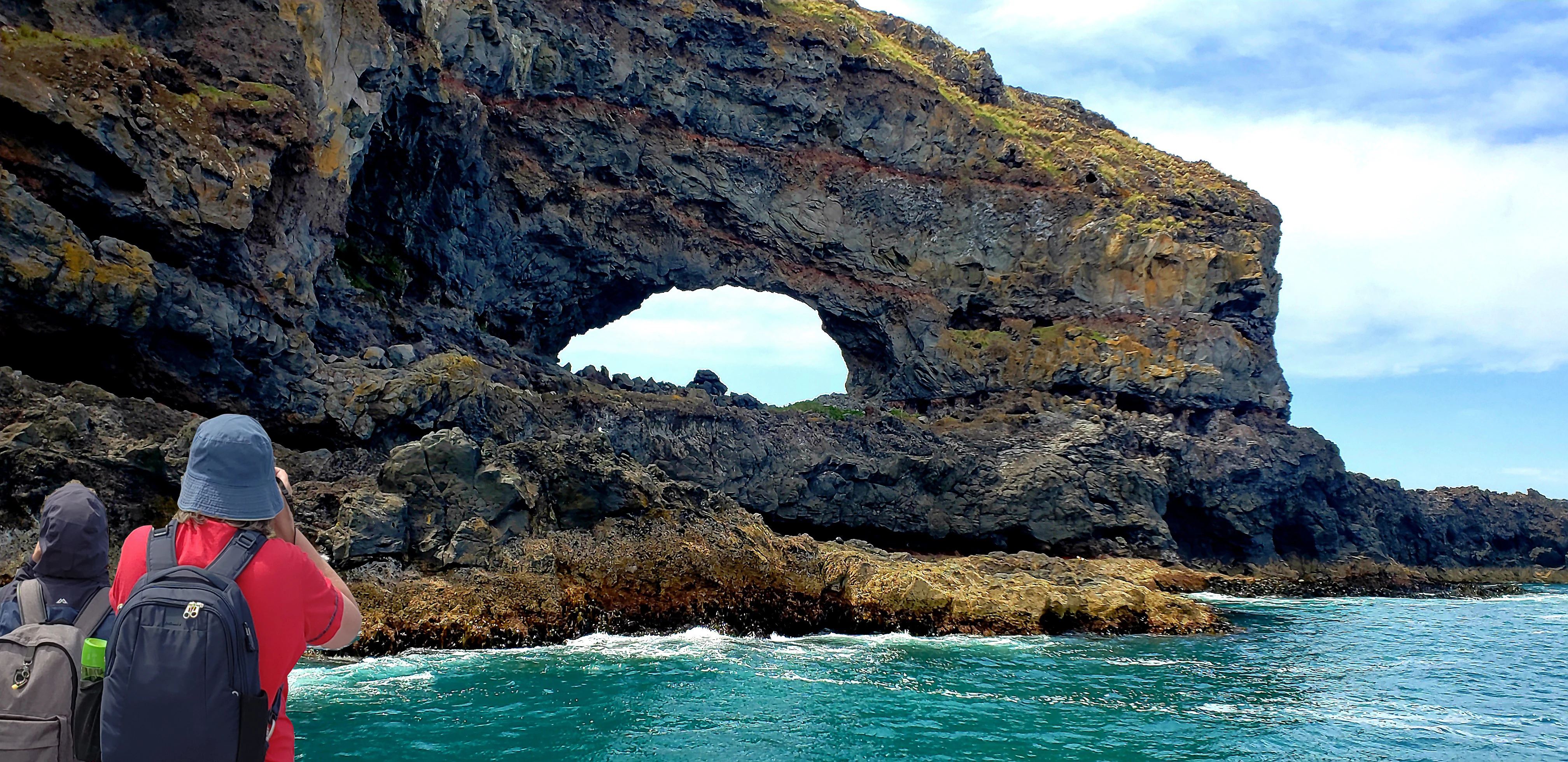
A view from the water showing a large natural stone archway in a coastal cliff face, with two people in the foreground on a boat looking toward it.
Visitors observe the natural sea arch formation near the coastline of Pōhatu Marine Reserve.

Pōhatu Marine Reserve history and protected-area timeline

The history of Pōhatu Marine Reserve is closely bound up with broader debates over marine protection in the Akaroa Harbour area during the 1990s and 2000s. The reserve's bay had long hosted a Kāti Māmoe pā, and Ōnuku Marae remains the closest marae to the site, reflecting the deep Māori connection to this stretch of coast.

In 1996, the Akaroa Harbour Marine Protection Society applied to establish a much larger 530 hectare marine reserve inside the harbour, south of Ōnuku Marae. The proposal drew objections from recreational and commercial fishers and from Te Rūnanga o Koukourārata, which asserted customary fishing interests and proposed instead that a tāiapure, a traditional Māori management tool, be established across the entire harbour. Fishers responding to the original proposal suggested a smaller alternative reserve at Pōhatu / Flea Bay, outside the harbour proper, and this compromise site was chosen because it was less politically contentious.

The reserve was formally notified in 1999, making it the first marine reserve on the east coast of the South Island. Yet its creation reshaped rather than resolved the surrounding debate. The runanga continued to pursue a tāiapure over the broader harbour, while some local families continued to fish in the reserve believing it to be a customary fishing ground. The Pōhatu decision effectively delayed the proposed tāiapure for around seven years and the later establishment of the Akaroa Marine Reserve for about fifteen years. In recognition of the site, the Department of Conservation also purchased land from a nearby farmer to create an adjoining land reserve.

Management history at the bay has also been shaped by the Helps family, who own much of the private land at the head of Pōhatu / Flea Bay. They campaigned for the marine reserve in part because no-take protection would prevent recreational fishers setting nets across penguin runs overnight. In 2021, Shireen and Francis Helps were recognised with the New Zealand Order of Merit for their conservation work protecting the penguin colony, a milestone that reflects how the reserve's history has become inseparable from community-led wildlife stewardship.

Pōhatu Marine Reserve landscape and geographic character

The landscape of the Pōhatu Marine Reserve is shaped by the volcanic origin of Banks Peninsula, with the bay sitting inside a deeply eroded harbour of ancient craters. High cliffs rise several hundred metres above the water, creating a sheltered amphitheatre around the bay that protects it from most winds and oceanic swells except in strong southerly weather. The result is a compact coastal basin ringed by steep walls of dark volcanic rock and riven by ridges that fall sharply to the sea.

At the waterline, the scenery of the reserve shifts between contrasting coastal forms. Sandy stretches alternate with reef platforms and sharp rocky outcrops, and kelp beds lend darker tones to the nearshore waters. The bay's entrance is defined by headlands at Ounu-hau Point and Redcliffe Point, while the surrounding shoreline incorporates smaller bays such as Damons Bay (Mangarohotu) and Strong Bay (Ōpatoti). The bay itself is wide and open inside the cliffs, with sandy bottom sediments and underwater visibility that is generally clear.

Onshore, the landscape above the reserve is largely pastoral. Private farmland and rolling grazed hills frame the bay, contrasting with the wilder cliffs and bush patches that line the reserve's edges. Walking routes such as the Banks Peninsula Track cross this terrain, linking the bay to Akaroa and to neighbouring inlets like Stony Bay. The combination of farm country, cliff-lined coast, and reef-rich sea defines the visual character of Pōhatu as a working rural coastline set alongside a wild marine environment.
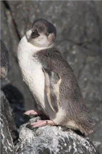
A white-flippered penguin standing on dark, textured rocks, looking toward the camera.
A white-flippered penguin, also known as the Banks Peninsula little penguin, perched on coastal rocks.

Pōhatu Marine Reserve ecosystems, habitats, and plant life

The ecological character of Pōhatu Marine Reserve reflects the overlap between volcanic shelf habitats and the broader temperate marine environment of the Canterbury coast. Within the reserve, the intertidal and shallow subtidal zones are dominated by kelp-covered reefs growing over rocky platforms, with sandy patches interspersed at the head of the bay where softer sediment shifts in and out with tidal currents. These reef and sand habitats combine to support a rich community of marine invertebrates and reef fish in a relatively small area.

Beyond the bay, the wider marine setting plays a major ecological role. The southerly current that runs along the Canterbury Bight delivers nutrients into the reserve's waters, supporting productivity across the food web. This nutrient flow, combined with the shelter provided by the cliffs, helps explain the diversity of species recorded both in baseline surveys and in ongoing observations.

On land, the bay's headland and adjoining private farmland move from open pasture into patches of coastal vegetation and scrub that form an important transition zone between marine and terrestrial habitats. This band of land supports nesting burrows above the beach and provides refuge for marine predator species, including seabirds that commute between cliffs, scrub, and ocean. The reserve's ecological role is therefore not just marine; it includes functioning as part of a connected coastal ecosystem that links ocean, reef, beach, and cliff.
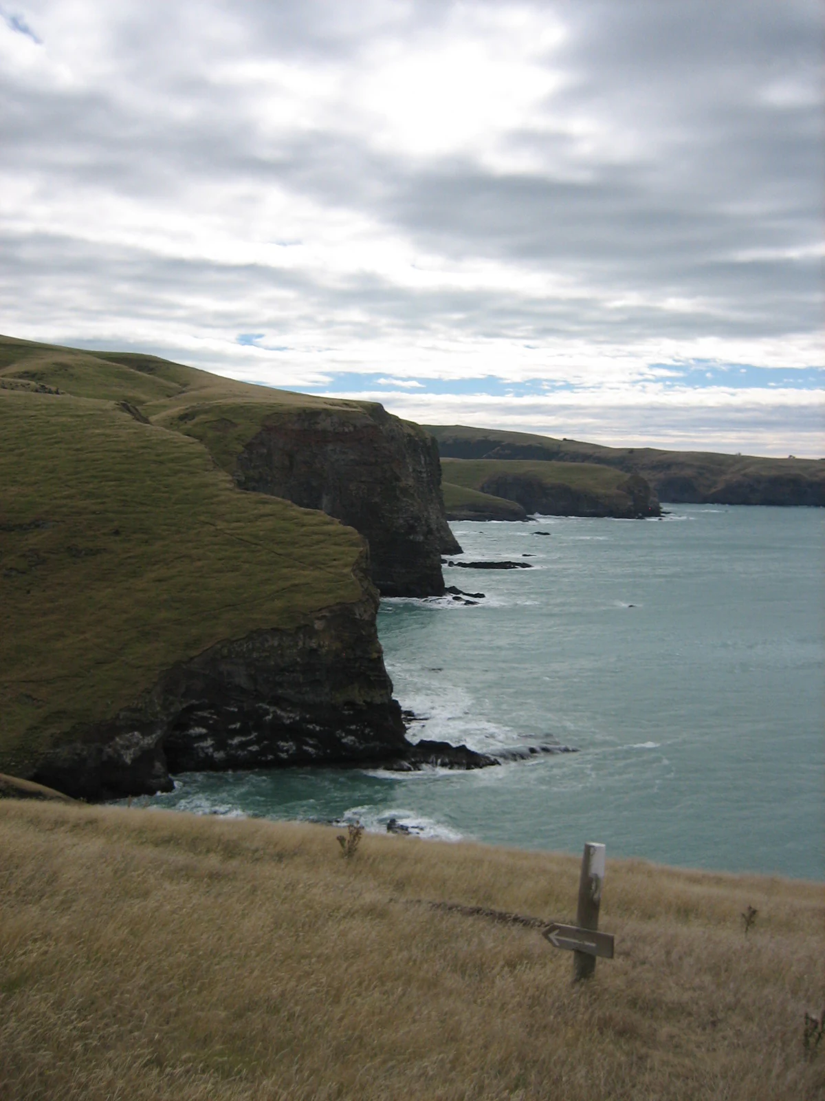
A coastal landscape view featuring steep, grass-covered cliffs dropping into the ocean under a cloudy sky, with a small trail marker post in the foreground.
Coastal cliffs along the Banks Peninsula Track, overlooking the Pōhatu Marine Reserve.

Pōhatu Marine Reserve wildlife and species highlights

Pōhatu Marine Reserve is widely recognised for its marine megafauna, particularly its dolphins. Hector's dolphins (Cephalorhynchus hectori), one of the world's rarest small cetaceans, regularly feed in the bay and along the surrounding peninsula coast. Dusky dolphins (Lagenorhynchus obscurus) are also visitors, and New Zealand fur seals (Arctocephalus forsteri), known locally as kekono, haul out and forage around the bay.

The reserve's intertidal and shallow subtidal communities are equally notable. Reef habitats shelter pāua, mussels, kina (sea urchins), limpets, sea tulips, crabs, and crayfish, while reef fish species recorded in and around the marine reserve include blue cod, blue moki, tarakihi, sea perch, trumpeter, and red cod. Baseline and follow-up surveys have shown measurable responses to protection, with legal-sized blue cod becoming substantially more common and slightly larger inside the reserve than at nearby unprotected sites.

The wildlife story most closely associated with Pōhatu, however, is its penguin colony. The beach at the head of the bay, set against private farmland, supports breeding populations of kororā (little blue penguin) and hoiho (yellow-eyed penguin). This is the largest colony on Banks Peninsula, and breeding numbers have grown from around 700 to more than 1,200 nests over an eighteen-year period, despite setbacks from severe weather events linked to consecutive El Niño years and pressure from aerial predators such as giant petrels (Macronectes).

Pōhatu Marine Reserve conservation status and protection priorities

Pōhatu Marine Reserve is a no-take marine protected area, managed by the New Zealand Department of Conservation with the primary purpose of preserving marine biodiversity and ecosystem function on this stretch of the Banks Peninsula coast. While small in area, the reserve's no-take status offers direct protection for reef habitats and fish populations that have historically been subject to recreational and commercial fishing pressure.

Beyond its marine focus, the reserve is also an important anchor for coastal seabird conservation. The adjoining penguin colony at Pōhatu / Flea Bay represents one of the most intensively managed populations of kororā and hoiho on Banks Peninsula. The Helps family, who own much of the adjacent private land, carry out predator control, population monitoring, and habitat protection with support from the Department of Conservation and volunteer groups. In 2021, their conservation contribution was formally recognised with the New Zealand Order of Merit.

Cultural recognition also plays a role in how the reserve is managed. Members of the Ōnuku runanga were granted permission in 2008 to take pāua in the reserve after surveys showed customary harvest levels would not compromise the population, an arrangement that reflects the reserve's position as both a strict ecological reserve and a site where traditional Māori kaitiakitanga continues. The reserve serves as a model of community-led marine and coastal conservation, where ecological monitoring, customary harvest, and penguin stewardship operate alongside one another.

Pōhatu Marine Reserve cultural meaning and human context

Pōhatu Marine Reserve sits within a coastal landscape that has long been part of Māori life. A Kāti Māmoe pā once stood in the bay, and the surrounding coastline remains tied to Ōnuku Marae, the closest marae to the reserve. The name Pōhatu itself is a traditional Māori name for the bay, commonly interpreted as 'place of stones' or 'struck by a stone'. The bay now carries an official dual name, Pōhatu / Flea Bay, that reflects both this Māori heritage and the European settler history.

European arrival on the peninsula brought pastoral farming to the bay. Israel and Martha Rhodes farmed the area in the 1840s, and the Rhodes family and other settlers believed the bay's English name, Flea Bay, derived from fleas hosted in sand contaminated by introduced cattle and pigs, rather than from a sense of 'fleeing' from storms, although charts from HMS Acheron in 1838 refer to the area as Boat Shelter Cove. This naming history has shaped how the reserve itself is referenced today.

Contemporary cultural context at the reserve continues to blend Māori kaitiakitanga with European-style community stewardship. Customary fishing rights are exercised in a measured way by the Ōnuku runanga, while private landowners carry out long-running conservation work on behalf of the wider New Zealand public, producing a layered model of cultural and ecological responsibility that informs both the reserve's management and its identity.

Top sights and standout views in Pōhatu Marine Reserve

Pōhatu Marine Reserve offers a rare combination of marine and coastal wildlife protection in a single small site. It protects approximately 215 hectares of kelp-forest reef, sandy bay, and cliff-lined coast within the volcanic heart of Banks Peninsula. The reserve is home to Hector's dolphins, New Zealand fur seals, and a productive intertidal community of shellfish, kina, and reef fish, with measurable increases in blue cod biomass and species richness recorded inside its boundaries compared with neighbouring unprotected areas.

A striking highlight is the adjoining penguin colony at Pōhatu / Flea Bay, the largest on Banks Peninsula. The combination of predator control by the private landowners, formal marine protection, and ongoing community involvement has allowed breeding populations to grow substantially. Together, the marine reserve and the penguin programme make the bay a nationally recognised example of integrated coastal conservation in New Zealand.

Best time to visit Pōhatu Marine Reserve

As a small, sheltered bay with limited road access, Pōhatu Marine Reserve has a relatively narrow seasonal window for comfortable on-the-ground visits. Access is via a steep and unsealed road 15 kilometres south of Akaroa, and the reserve is best approached on foot, by kayak, or by four-wheel drive when conditions allow. Low tide tends to expand opportunities for intertidal exploration and viewing of reef communities, while southerly weather can disrupt otherwise calm seas inside the bay.

Spring and summer typically offer milder conditions, longer daylight hours, and the most active period for wildlife viewing, including breeding penguins on the adjacent beach. Winter brings harsher weather, rougher seas, and cooler temperatures, though the underlying marine environment and seabird activity remain year-round features. Visitors interested in seeing penguins ashore are generally best served by warmer months, when breeding and predator management are most active.
Monthly climate preview

Measured monthly temperature ranges and precipitation averages across representative Canterbury terrain

Pōhatu Marine Reserve Climate Normals and Long Term Weather Patterns

Long term climatology data for Pōhatu Marine Reserve records average monthly temperatures ranging from 8.48 degrees Celsius to 15.34 degrees Celsius alongside steady precipitation rates. Reviewing the complete twelve month statistical profile reveals detailed seasonal temperature shifts and monthly precipitation variations across the representative coordinate.
Annual mean12 °C
8 °C15 °C
Jan15°
Feb15°
Mar14°
Apr13°
May11°
Jun
Jul
Aug
Sep
Oct11°
Nov12°
Dec14°
Warmest month
February

15.3 °C

Coolest month
July

8.5 °C

Wettest month
June

2.4 mm/day

Driest month
February

1.6 mm/day

Park location guide

Geography guide, regional context, and park location map for Pōhatu Marine Reserve

Pōhatu Marine Reserve park geography, regions, and map view in New Zealand

Understand where Pōhatu Marine Reserve sits in New Zealand through a broader geographic reading of the surrounding landscape, nearby location context, and its mapped position within the national park landscape.

How Pōhatu Marine Reserve fits into New Zealand

New Zealand is an island nation in the southwestern Pacific Ocean comprising two main islands and numerous smaller islands. Located east of Australia across the Tasman Sea, it features varied topography with the Southern Alps running along the South Island and volcanic terrain on the North Island. The country was settled by Maori people between 1280 and 1350, followed by European exploration beginning in 1642, and became a Dominion in 1907 before gaining full independence in 1947.

Wider geography shaping Pōhatu Marine Reserve in New Zealand

New Zealand lies in the southwestern Pacific Ocean, east of Australia across the Tasman Sea. The country consists of two main islands, the North Island and South Island, plus over 600 smaller islands. The North Island features volcanic plateaus and hills while the South Island is dominated by the Southern Alps mountain range. The country has a long coastline and is surrounded by the Pacific Ocean.

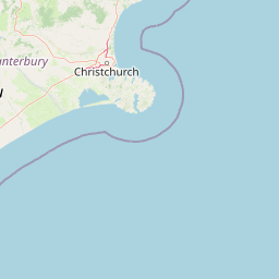
Map view of Pōhatu Marine Reserve

Use this park location map to pinpoint Pōhatu Marine Reserve in New Zealand, understand its exact geographic position, and read its mapped placement within the surrounding landscape more clearly.

Pigeon | © OpenStreetMap contributors

Location context for Pōhatu Marine Reserve

Canterbury
Recorded earthquake history

Examine the Historical Seismic Data Record for Pōhatu Marine Reserve

View a structured catalogue of earthquakes recorded in the vicinity of Pōhatu Marine Reserve. This MoriAtlas resource presents historical event data, including magnitudes and epicentre locations, to assist in understanding the seismic geography of the Canterbury coastline.

Pōhatu Marine Reserve Earthquake History

Catalogued events

313 events

Strongest magnitude

Magnitude 6.1

Most recent event

Mar 14, 2024

This history includes earthquakes recorded inside the park or within 50 km of its borders

Visualizing the protected reefs, rugged cliffs, and marine habitats of Banks Peninsula

Pōhatu Marine Reserve Photos and Volcanic Coastal Landscapes

Examinations of Pōhatu Marine Reserve reveal a dramatic volcanic coastline defined by steep rock walls, kelp forests, and sheltered bays. Photographic collections provide direct visual reference for understanding the unique terrain and protected marine environments of the region.

A view from the water showing a large natural stone archway in a coastal cliff face, with two people in the foreground on a boat looking toward it.

A wide, sunlit view of a grass-covered valley and rolling hills in the Pōhatu Marine Reserve area, with some small structures visible in the distance.

A white-flippered penguin standing on dark, textured rocks, looking toward the camera.

A coastal landscape view featuring steep, grass-covered cliffs dropping into the ocean under a cloudy sky, with a small trail marker post in the foreground.

Park atlas

Discover adjacent marine reserves and connected coastal landscapes across the Canterbury region

Explore Protected Areas and Parks Near Pōhatu Marine Reserve

Compare Pōhatu Marine Reserve with other protected coastal environments and regional marine habitats across the surrounding New Zealand coastline. Broader geographic comparison reveals how isolated reserves connect to wider regional conservation networks.
A horizontal watercolor illustration showing a calm bay surrounded by rolling hills and soft greenery, with faint mountains in the background.
Marine protected areaNew Zealand
2.4 km away#1 closest

West

Akaroa Marine Reserve: Protected Harbour Geography and Marine Map

Volcanic coastal terrain and no-take zone boundaries

Located on the Banks Peninsula, Akaroa Marine Reserve represents a vital marine protected area within a deeply indented volcanic harbour. The reserve offers a unique look at the contrast between inner harbour mudflats and outer rocky reefs, serving as an essential case study for marine conservation and coastal geography in New Zealand.

Area
5.12 km²
Established
2014
IUCN
Ia
Relief
Lowland
Regional parkCanterbury Region
About 59 km away#2 closest

Northwest

Waimakariri River Regional Park: Geography and Protected Landscape Atlas for Canterbury

Braided river corridors and wetland habitats in the Canterbury Region

Waimakariri River Regional Park encompasses a significant managed corridor along the Waimakariri River, featuring an intricate mix of braided riverbeds, saltmarshes, and reforested land. This profile details the park topography, highlighting its role in regional flood management and its varied natural terrain across the Canterbury Plains, providing a clear geographic view of its multi-use protected boundaries.

Area
150 km²
Relief
Lowland
Access
Easy access
Scope
Terrestrial
A horizontal watercolor illustration depicting a coastal landscape with winding light-colored sandbars, pale water channels, and soft green rolling hills under a muted pastel sky.
Regional parkCanterbury Region
About 65 km away#3 closest

Northwest

Northern Pegasus Bay Regional Park: Canterbury Coastal Geography and Protected Land Atlas

Mapping the beaches, estuaries, and dunes of Northern Pegasus Bay.

Northern Pegasus Bay spans a long, curving stretch of the Canterbury coastline on New Zealand's South Island. This regional park protects a range of coastal landforms, including pebbly beaches, dune systems, and the regionally significant Ashley Rakahuri Estuary. The geography reflects a dynamic exchange of sediment across multiple river mouths, creating a distinct environmental corridor between coastal communities and the sea.

Relief
Lowland
Climate
Temperate
Access
Easy access
Scope
Mixed
A soft watercolor illustration featuring a panoramic view of rolling green hills, distant mountains, a meandering stream, and wildflowers in the foreground.
Protected landscapeSouth Island
About 130 km away#4 closest

Northwest

Craigieburn Forest Park: Protected Alpine Landscape and Southern Alps Geography

High country terrain from beech forests to alpine ridges.

Situated along the eastern flanks of the Southern Alps, Craigieburn Forest Park offers a complex mountain geography that serves as both a recreational hub and an ecological restoration zone. The area features a clear transition from beech-clad valley floors and glacial terraces to wide tussock basins and craggy summits, providing a detailed look at the diverse natural terrain of the Canterbury region.

Area
446.948 km²
Established
1967
Relief
Mountain
Climate
Alpine
National parkNew Zealand
132 km away#5 closest

Northwest

Arthur's Pass National Park: Dramatic Alpine Protected Landscape in the Southern Alps

Explore the unique geography and mapped boundaries of this South Island national park.

Arthur's Pass National Park, a substantial protected area within New Zealand's Southern Alps, presents a compelling focus for geographic and atlas exploration. Characterized by dramatic alpine terrain shaped by ancient glacial forces, the park exhibits a striking ecological contrast between its drier eastern beech forests and wetter western rainforests. Users can delve into the mapped park boundaries and understand the regional landscape context of this unique protected area, making it a key destination for understanding New Zealand's natural geography.

Area
1,184.7 km²
Established
1929
IUCN
II
Relief
Mountain
A soft watercolor painting of stylized, rolling green hills against a white background.
Nature reserveNew Zealand
About 142 km away#6 closest

West

Peel Forest Park Nature Reserve: Mapped Geography and Protected Forest Landscapes

Canterbury Foothills and Southern Alps transition zone

Located in the foothills of New Zealand, Peel Forest Park preserves a significant fragment of native podocarp forest. This reserve features a diverse landscape of river valleys and forested slopes, offering a clear view of the transition from the Canterbury Plains to the Southern Alps massif.

Area
7.686 km²
Established
1909
Relief
Mountain
Climate
Temperate
Marine protected areaCanterbury
150 km away#7 closest

North

Hikurangi Marine Reserve: Protected Marine Geography and Submarine Canyon Systems

Exploring the coastal reefs and deep trench environments of Canterbury

Hikurangi Marine Reserve represents a core protected landscape within the New Zealand marine atlas. Centered on the Kaikoura Canyon, the reserve features a sharp transition from rocky shoreline reefs to deep-sea environments that support a high density of cetaceans and seabirds. This map-focused profile examines the physical boundaries and unique oceanographic conditions that define this essential no-take marine zone.

Area
104.16 km²
Established
2014
IUCN
Ia
Relief
Lowland
Protected landscapeCanterbury
About 152 km away#8 closest

Northwest

Lake Sumner Forest Park: Geography and Protected Landscape Atlas for Canterbury

Mountainous river valleys and remote beech forests

Spanning over 100,000 hectares of the Canterbury high country, Lake Sumner Forest Park stands as a prime example of New Zealand's protected backcountry. This mapping resource details the park's river-carved terrain, subalpine fringes, and its role as a connective wilderness area between major South Island mountain ranges.

Area
1,051 km²
Relief
Mountain
Climate
Temperate
Access
Moderate access

Common questions about visiting, size, designation, and location context for Pōhatu Marine Reserve

Pōhatu Marine Reserve FAQs for park facts, access, geography, and protected area context

Find quick answers about Pōhatu Marine Reserve, including protected-area facts, park geography, trail and visitor context, and how the park fits into its surrounding country and regional landscape.
MoriAtlas Explorer

Continue Your Protected Areas Search Across the Global Atlas

Deepen your exploration by continuing the structured search for national parks and protected areas worldwide. Utilize the comprehensive filtering capabilities to compare different conservation landscapes and refine your understanding of global park geography. Discover more about the distribution and characteristics of protected natural areas.

Global natural geography