Mori Atlas logo
Marine protected areaPort Barton Marine Park

A community-managed marine protected area defined by small islands and underwater reef structures.

Port Barton Marine Park: Mapping the Protected Reef Ecosystems and Coastal Geography of Palawan

Located on the western coast of Palawan, Port Barton Marine Park preserves a significant coastal and marine landscape within the sheltered waters of Pagdanan Bay. This protected area features a network of small islands and submerged reef formations, including Manta Ray Reef and Black Coral Reef, which serve as essential nursery zones. Through its distinctive grassroots management framework involving local fishermen and community leaders, the marine park represents a vital regional model for tropical marine conservation and coastal geography.

marine protected areacoral reefislandsPalawanPhilippinescommunity-based conservation

Port Barton Marine Park

Marine protected area

Park overview

Structured park overview, official facts, and landscape profile for Port Barton Marine Park

Port Barton Marine Park park facts, protected area profile, and essential visitor context

Review the core facts for Port Barton Marine Park, including designation, size, terrain, visitor scale, habitats, and operating context in one park-focused overview.

About Port Barton Marine Park

Port Barton Marine Park is a marine protected area on the western edge of Palawan Island in the southwestern Philippines. It occupies the inner waters of Pagdanan Bay, a sheltered coastal indentation that fronts the small town of Port Barton in the municipality of San Vicente. From the provincial capital Puerto Princesa, the park lies roughly 120 kilometers to the northeast along Palawan's western coastline.

The park covers approximately 744.83 square kilometers of marine and coastal environment. Its geography is defined less by a single landmass than by a constellation of small islands, scattered reef formations, and the broader bay waters that connect them. Among the included islands are Albaguen Island, Paraiso Island, and Exotic Island, while the underwater landscape is defined by reef systems such as Manta Ray Reef and Black Coral Reef. Together, these reef areas form the core zone of the sanctuary and act as both recreational dive sites and nursery habitats for commercially important fish species.

The significance of Port Barton Marine Park extends beyond its biodiversity. It is one of the better-known examples of community-based marine resource management in the Philippines. From the outset, the park was conceived as a partnership between the Palawan provincial government, the municipality of San Vicente, the Philippines' Department of Environment and Natural Resources, and the United States Agency for International Development. The management framework has been shaped through the Port Barton Coastal Resource Management Plan, a document developed jointly by these partners to coordinate protection, sustainable fishing practices, and enforcement.

Local leadership continues to define how the park operates. The Albaguen Fishermen's Association, the local ferry operators, and the municipal council of San Vicente play central roles in day-to-day stewardship. This local anchoring, combined with the area's appealing underwater scenery, has made Port Barton Marine Park both a working example of collaborative conservation and a regional destination for reef-based recreation on Palawan.

Quick facts and research context for Port Barton Marine Park

Port Barton Marine Park lies within Pagdanan Bay on the western coast of Palawan Island, in the MIMAROPA region of the Philippines. The protected area covers approximately 744.83 square kilometers of coastal and marine waters, including a scattered archipelago of small islands and associated reef systems.

The marine sanctuary was formally established on January 6, 1998, as a joint initiative of the Palawan provincial government, the municipality of San Vicente, the Department of Environment and Natural Resources, and the United States Agency for International Development. Day-to-day management is guided by the Port Barton Coastal Resource Management Plan, with leadership drawn primarily from local fishing associations and community representatives.

Protection and recognition

Examine the documented marine protection scope and official designation records.

Port Barton Marine Park Protection Status and Conservation Recognition

Port Barton Marine Park maintains a documented marine protection scope within official conservation databases. Regional analysts and conservation researchers review these records to understand protected area designations and management boundaries.

Protection details

Protection scope
Marine
Transboundary protection
No
WDPA ID
305910
Park context

Deeper park guide and search-rich context for Port Barton Marine Park

Port Barton Marine Park history, landscape, wildlife, and travel context

Explore Port Barton Marine Park through its history, landscape character, ecosystems, wildlife, conservation priorities, cultural context, and seasonal travel timing in a structured park guide built for atlas discovery and search intent.

Why Port Barton Marine Park stands out

Port Barton Marine Park is best known for its network of coral reefs and small offshore islands within Pagdanan Bay, which form the heart of the marine protected area. Named reef sites such as Manta Ray Reef and the Black Coral Reef have given the park a strong reputation among divers and snorkelers exploring northern Palawan. Equally important to the park's identity is its community-based governance model. Unlike many larger Philippine marine reserves managed primarily from Manila or the provincial capital, Port Barton's management structure is rooted in local institutions, particularly the Albaguen Fishermen's Association and cooperating ferry operators. This combination of distinctive reef ecosystems and grassroots stewardship has defined the park's profile both ecologically and socially.

Port Barton Marine Park history and protected-area timeline

Port Barton Marine Park was formally established on January 6, 1998, following nearly two years of inter-agency coordination that began in the late 1990s. The initiative brought together four principal partners: the provincial government of Palawan, the municipality of San Vicente, the Philippine Department of Environment and Natural Resources, and the United States Agency for International Development.

These partners collaborated on the Port Barton Coastal Resource Management Plan, a joint framework that laid out sanctuary zones, allowed uses, and management responsibilities. The plan reflected a deliberate choice to anchor the protected area in local institutions rather than to impose a purely top-down structure. The Albaguen Fishermen's Association, ferry operators serving the bay, and the broader municipal leadership of San Vicente were given a central role in the park's day-to-day stewardship, a governance arrangement that has remained a defining feature of the project.

The park's ecological history has not been without setbacks. Severe coral bleaching events affected the reefs in 1998 and 1999, driven by the El Niño climate anomaly of that period. A second significant bleaching event impacted the underwater formations in 2010. Earlier coral damage was also attributed to Typhoon Norming, which struck the area during the 1998 storm season. These disturbances underscored both the vulnerability of the reef systems and the importance of continued local management in supporting reef recovery.

Port Barton Marine Park landscape and geographic character

The landscape of Port Barton Marine Park is defined by the waters and small islands of Pagdanan Bay, a sheltered coastal inlet on the western shore of Palawan. Rather than a terrestrial mountain or forest setting, the park's physical character is overwhelmingly marine and littoral, shaped by tidal waters, fringing coastlines, and submerged reef structures.

Resting within the bay are several small islands that punctuate the seascape. Albaguen Island, Paraiso Island, and Exotic Island are among the named land features within the protected area. These islands function as both visual landmarks and ecological anchor points; their surrounding shallows support reef growth and act as natural boundaries within the larger sanctuary.

Underwater, the landscape continues through reef formations such as Manta Ray Reef and Black Coral Reef. These reef systems rise from the deeper sediments of the bay toward the surface, creating complex vertical and lateral structures that have become signature features of the park. The combination of small green-topped islands, calm bay waters, and undulating reef terrain makes Port Barton's seascape both visually distinctive and ecologically significant.

Port Barton Marine Park ecosystems, habitats, and plant life

Port Barton Marine Park protects a tropical marine ecosystem typical of the western Palawan coastline. The sheltered waters of Pagdanan Bay support a mosaic of habitats, including fringing reefs around the small islands, patch reefs scattered across the bay floor, and deeper soft-bottom zones that connect the reef structures. Together, these habitats form an interconnected system in which reef health directly influences the productivity of surrounding waters.

The reef systems, particularly the Manta Ray Reef and Black Coral Reef, sit at the core of the park's ecological value. Hard corals dominate the reef framework, while black coral formations contribute to the habitat's structural complexity. The reef zones serve as nursery areas where juvenile fish can develop away from the pressures of open-water fishing, and as feeding and resting grounds for larger marine species that move through the bay.

Mangrove fringes along parts of the mainland shoreline, where they occur within the protected boundary, contribute to the broader ecological mosaic by stabilizing sediments, filtering runoff, and providing nursery habitat for a range of marine species. The combination of reef, mangrove, and open bay environments gives Port Barton Marine Park a layered ecological character that goes beyond a single reef system.

Port Barton Marine Park wildlife and species highlights

The wildlife focus of Port Barton Marine Park is overwhelmingly marine. The reef systems of Pagdanan Bay support a diverse community of reef-associated fish, invertebrates, and larger pelagic visitors. The presence of named features such as Manta Ray Reef points to the historical or seasonal occurrence of manta rays within the bay's waters, while the broader reef habitat sustains a range of reef fish that underpin both the local fishery and the area's recreational appeal.

Coral itself forms part of the park's living wildlife, with both hard corals and black corals playing a structural and ecological role. The bleaching events of the late 1990s and 2010 represented major disturbances to this coral community, after which gradual recolonization of affected areas became a long-term ecological priority.

Sea turtles, sharks, and a range of smaller reef predators have historically been associated with the broader Palawan reef environment, and the protected status of the bay supports their continued presence inside the sanctuary. The reef's role as a fish nursery also means that the populations replenishing fisheries outside the reserve are partly sustained by conditions within the park itself.

Port Barton Marine Park conservation status and protection priorities

Port Barton Marine Park plays a meaningful role in marine conservation in northern Palawan. By formally protecting the waters of Pagdanan Bay and its associated islands and reefs, the park creates a refuge where fish populations can reproduce and grow, supporting both biodiversity inside the sanctuary and the productivity of fishing grounds in surrounding waters.

The park's conservation significance is closely tied to its community-based management. The involvement of the Albaguen Fishermen's Association, ferry operators, and the municipal government of San Vicente gives local stakeholders both a stake and a direct role in enforcing sanctuary rules, monitoring reef health, and resolving conflicts over resource use. This approach is consistent with broader Philippine efforts to promote co-management of coastal resources.

The bleaching events of 1998, 1999, and 2010, combined with physical damage from Typhoon Norming in 1998, have repeatedly tested the resilience of the park's reef systems. Recovery has depended on the persistence of conservation efforts at the local level, making the park not only a place of ecological protection but also a long-term case study in how community-led management responds to climate and storm-driven disturbances on tropical reefs.

Port Barton Marine Park cultural meaning and human context

The cultural context of Port Barton Marine Park is inseparable from the fishing and coastal life of the surrounding community. The Albaguen Fishermen's Association is both a working fishing organization and a formal participant in the park's management structure, reflecting how the livelihoods of local residents and the protection of marine resources are closely linked rather than treated as separate domains.

The municipality of San Vicente, the local ferry operators who connect Port Barton with surrounding island destinations, and the broader community all have a recognized role in guiding the park's decisions. This gives the park a strongly local governance identity in a country where marine protected areas are often established and administered primarily through national agencies. The model reflects a deliberate effort to give coastal communities meaningful responsibility over the waters their families have relied upon for generations.

Top sights and standout views in Port Barton Marine Park

Port Barton Marine Park's strongest distinguishing features include its constellation of small islands, its named reef systems, and its community-led governance structure. The presence of Manta Ray Reef and Black Coral Reef within a single protected bay gives the park a depth of underwater character that has brought it regional recognition among divers and naturalists exploring Palawan.

Equally notable is the way the park is managed. Rather than relying on remote administration, the reserve is shaped day-to-day by local fisherfolk, ferry operators, and municipal leaders, an arrangement that ties conservation outcomes directly to the priorities and participation of the surrounding community.
Monthly climate preview

Long term temperature averages and monthly precipitation records for Palawan

Port Barton Marine Park Climate Normals and Annual Weather Patterns

Port Barton Marine Park exhibits a measured annual cycle of sustained baseline temperatures alongside distinct monthly precipitation variations recorded between nineteen ninety one and twenty twenty. Reviewing the complete twelve month profile provides granular baseline data for analyzing long term thermal and moisture rhythms across the coordinate.
Annual mean28 °C
27 °C29 °C
Jan27°
Feb27°
Mar28°
Apr29°
May29°
Jun28°
Jul28°
Aug28°
Sep27°
Oct27°
Nov28°
Dec27°
Warmest month
May

29.2 °C

Coolest month
January

26.5 °C

Wettest month
July

9.4 mm/day

Driest month
March

0.9 mm/day

Park location guide

Geography guide, regional context, and park location map for Port Barton Marine Park

Port Barton Marine Park park geography, regions, and map view in Philippines

Understand where Port Barton Marine Park sits in Philippines through a broader geographic reading of the surrounding landscape, nearby location context, and its mapped position within the national park landscape.

How Port Barton Marine Park fits into Philippines

The Philippines, officially the Republic of the Philippines, is an archipelagic nation in Southeast Asia comprising approximately 7,641 islands categorized into three main geographical divisions: Luzon, Visayas, and Mindanao. Located in the western Pacific Ocean, it shares maritime borders with Taiwan, Japan, Palau, Indonesia, Malaysia, Vietnam, and China. Manila serves as the capital city, while Quezon City is the most populated city, both within Metro Manila.

Wider geography shaping Port Barton Marine Park in Philippines

The Philippines is an archipelagic nation in Southeast Asia, positioned in the western Pacific Ocean. Its islands are bounded by the South China Sea to the west, Philippine Sea to the east, and Celebes Sea to the south. The country shares maritime borders with Taiwan to the north, Japan to the northeast, Palau to the east and southeast, Indonesia to the south, Malaysia to the southwest, Vietnam to the west, and China to the northwest.

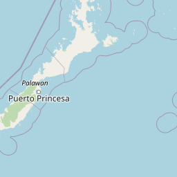
Map view of Port Barton Marine Park

Use this park location map to pinpoint Port Barton Marine Park in Philippines, understand its exact geographic position, and read its mapped placement within the surrounding landscape more clearly.

Pigeon | © OpenStreetMap contributors

Location context for Port Barton Marine Park

Palawan
Park atlas

Compare regional marine reserves and connected coastal landscapes across northern Palawan

Explore Other Parks and Protected Areas Near Port Barton Marine Park

Continue browsing other protected areas near Port Barton Marine Park to compare regional marine ecosystems and coastal geography. Expanding the geographic scope helps connect individual island habitats with broader conservation zones across the surrounding region.
National parkPalawan
About 29 km away#1 closest

Southwest

Puerto Princesa Subterranean River National Park: Palawan's Protected Landscape Discovery

Mapped natural terrain and regional park geography.

Gain a structured understanding of Puerto Princesa Subterranean River National Park, a protected national park located in Palawan. This page details its geographic setting, contributing to a broader atlas of conservation landscapes. Explore the mapped boundaries and natural terrain that define this significant protected area, offering valuable context for regional geographic discovery.

Area
222.02 km²
Established
1999
IUCN
III
Relief
Mountain
Protected landscapePalawan
About 47 km away#2 closest

Northeast

Malampaya Sound Protected Landscape/Seascape: Geographic Atlas and Coastal Park Boundaries

A combined marine and terrestrial protected area in Palawan, Philippines

Gain insights into the geographic composition of Malampaya Sound Protected Landscape/Seascape. This expansive site on Palawan island encompasses sheltered bays, island chains, and mangrove-fringed shorelines. Examine the structural balance between brackish-water ecosystems, essential tidal flats, and local fishing barangays within a single managed maritime reserve.

Area
2,015.66 km²
Established
2000
Relief
Lowland
Scope
Mixed
A soft, panoramic watercolor painting depicting a coastal landscape with green rolling hills, distant mountains, and a pale shoreline.
Protected landscapePalawan
About 91 km away#3 closest

North

El Nido-Taytay Managed Resource Protected Area: A Coastal Karst and Marine Landscape Atlas

Mapping the terrestrial and marine boundaries of northern Palawan.

An authoritative overview of the El Nido-Taytay Managed Resource Protected Area, detailing its extensive karst limestone islands, hidden lagoons, and diverse coastal ecosystems. This record maps the intersection of terrestrial forests and marine habitats that span the municipalities of El Nido and Taytay, providing a clear geographic context for this significant Philippine protected landscape.

Area
923.34 km²
Established
1998
Wildlife reservePalawan
About 155 km away#4 closest

Southwest

Rasa Island Wildlife Sanctuary: Protected Coastal Landscapes and Island Geography

Integrated marine and terrestrial wildlife reserve in Palawan

Positioned in the Sulu Sea off the coast of Palawan, Rasa Island Wildlife Sanctuary protects a rare concentration of mangrove forests, coastal woodland, and reef flats. This compact land and sea reserve serves as an essential sanctuary for bird species and nesting marine turtles, offering a clear window into the biodiversity of the Palawan island province through its preserved island geography.

Area
19.83 km²
Established
2006
Relief
Lowland
Climate
Tropical
A horizontal watercolor illustration depicting layers of green, hilly landscapes against a pale pink sky, reflected in calm blue water.
Protected areaPalawan
About 204 km away#5 closest

Northeast

Coron Island Protected Area: Mapping the Limestone Karst and Inland Lakes of Palawan

Karst terrain and marine protected landscapes in the Calamian Islands

Discover the geographic structure of Coron Island Protected Area, where towering limestone ridges and cliffs surround secluded freshwater lakes. The territory preserves a diverse ecosystem of coastal mangroves and marine waters within the Palawan province, illustrating a unique intersection of geological history and traditional indigenous stewardship.

Area
222.48 km²
Established
1998
Relief
Upland
Scope
Mixed
Wildlife reserveMimaropa
About 221 km away#6 closest

North

Calauit Safari Park: Wildlife Reserve Geography and Protected Island Terrain

A conservation sanctuary within the Mimaropa region, Philippines.

Calauit Safari Park stands out as a unique wildlife reserve in the Calamian Islands, featuring a rare combination of African savanna animals and native Philippine wildlife. Its 3,700 hectares encompass a diverse array of tropical forests, grasslands, and mangrove-lined shores, reflecting a complex history of conservation and land management. This protected island ecosystem provides critical habitat for endangered species and serves as an important site for ecological recovery in the western Philippines.

Area
37 km²
Established
1976
Relief
Lowland
Climate
Tropical
A wide panoramic watercolor painting showing a body of water in the foreground, a green tree-lined shore in the midground, and faint mountains under a pink and yellow sky in the background.
Marine protected areaPhilippines
About 288 km away#7 closest

Northeast

Apo Reef Marine Natural Park: Protected Coral Reef Atlas and Marine Geography

Marine protected area in the Mindoro Strait, Philippines

Apo Reef Marine Natural Park serves as a high-priority conservation landscape featuring two massive triangular coral banks and steep underwater drop-offs. This site provides a critical case study in marine geomorphology, characterized by its deep submarine trenches and unique atoll-like structure within the broader Philippine archipelagic geography.

Area
274.69 km²
Established
1996
Scope
Marine
Water
Water-dominated
Wildlife reservePalawan
About 293 km away#8 closest

Southwest

Ursula Island Game Refuge and Bird Sanctuary: Geography and Protected Area Overview

An isolated wildlife reserve in the Sulu Sea, Palawan

The Ursula Island Game Refuge and Bird Sanctuary functions as a vital protected landscape, containing a rare mix of lowland rainforest and dense mangrove forests. Located offshore from the Palawan coastline, this seventeen hectare sanctuary provides essential nesting grounds and ecological refuge, illustrating the complex geography of small island conservation in the tropical Sulu Sea.

Area
0.172 km²
Established
1970
Relief
Lowland
Climate
Tropical

Common questions about visiting, size, designation, and location context for Port Barton Marine Park

Port Barton Marine Park FAQs for park facts, access, geography, and protected area context

Find quick answers about Port Barton Marine Park, including protected-area facts, park geography, trail and visitor context, and how the park fits into its surrounding country and regional landscape.
MoriAtlas Explorer

Continue Your Protected Areas Search Across the Global Atlas

Deepen your exploration by continuing the structured search for national parks and protected areas worldwide. Utilize the comprehensive filtering capabilities to compare different conservation landscapes and refine your understanding of global park geography. Discover more about the distribution and characteristics of protected natural areas.

Global natural geography