

Mori Atlas logo
Nature reservePrince Edward Islands

A remote subantarctic landscape featuring dramatic cliffs, tundra ecosystems, and vast oceanic conservation zones.

Prince Edward Islands Nature Reserve: Exploring the Volcanic Geography and Protected Marine Boundaries

(Prince Edward Islands Special Nature Reserve)

The Prince Edward Islands comprise two uninhabited volcanic islands rising from the southern Indian Ocean, serving as a critical subantarctic nature reserve under South African administration. This protected landscape encompasses Mascarin Peak and diverse tundra terrain, acting as a sanctuary for albatross, penguin, and seal populations. Through our atlas, visualize the rugged coastal topography and the expansive marine boundaries that define one of the most ecologically intact environments on the planet.

subantarctic islandsvolcanic islandsmarine protected areaspecial nature reserveseabird breeding coloniesalbatross habitat

Prince Edward Islands

Nature reserve

Park overview

Structured park overview, official facts, and landscape profile for Prince Edward Islands

Prince Edward Islands park facts, protected area profile, and essential visitor context

Review the core facts for Prince Edward Islands, including designation, size, terrain, visitor scale, habitats, and operating context in one park-focused overview.

About Prince Edward Islands

The Prince Edward Islands are a small but ecologically vital island group in the southern Indian Ocean, forming the emergent summits of a massive submarine shield volcano system. The group consists of Marion Island, the larger and higher of the two, and the smaller, more compact Prince Edward Island lying to its northeast. Their remoteness, their position within the Southern Ocean, and their strict protection together make them one of the most important subantarctic conservation areas under South African jurisdiction.

Marion Island is the dominant landmass, with a rugged coastline of mostly high cliffs, interior hillocks, scattered lakes, and boggy lowland terrain that reflects the cold and wet climate. Its highest point, Mascarin Peak, reaches more than 1,200 meters above sea level, and the underlying volcano has erupted several times in recent decades, making the island geologically active rather than ancient. Prince Edward Island is smaller and more compact, with rocky terrain, towering cliffs along its southwestern side, and offshore rocks such as Ship Rock and Ross Rocks marking an equally dramatic coastline.

Although the islands are technically within the south temperate zone, they have a tundra climate because they lie directly in the path of eastward-moving depressions and the powerful westerly winds known as the Roaring Forties. Annual rainfall is very high, sunshine is unusually limited, and temperatures remain cool throughout the year, with snow or frost possible in any season. The environment is austere but exceptionally clean, which is part of why the islands support such globally important wildlife populations and why they have been so heavily protected.

The Prince Edward Islands hold vast biological significance despite their small size. They are a designated Important Bird Area, a Ramsar Wetland, and the heart of the Prince Edward Islands Marine Protected Area. The islands are part of the broader Southern Indian Ocean Islands tundra ecoregion and serve as a refuge and breeding ground for a remarkable diversity of seabirds and marine mammals in an otherwise oceanic region with very few land masses.

Quick facts and research context for Prince Edward Islands

The Prince Edward Islands are a pair of volcanic subantarctic islands located in the southern Indian Ocean at roughly 46 to 47 degrees south latitude, well within the belt of the Roaring Forties westerlies. South Africa formally annexed both islands in 1947 and 1948, and today they are administered through the Western Cape province, falling under the jurisdiction of the Cape Town Magistrate's Court.

Both Marion Island and Prince Edward Island have been declared Special Nature Reserves, and their surrounding ocean waters form a Marine Protected Area of about 180,000 square kilometers. The islands have no permanent residents: the only human presence is a small meteorological and biological research station run by the South African National Antarctic Programme on Marion Island. They are a designated Important Bird Area and a Ramsar Wetland of international significance.

Protection and recognition

Documented protection history and official Ramsar wetland designations.

Prince Edward Islands Protection Status and International Recognition

Prince Edward Islands holds a mixed protection scope established in 2003 with recognized Ramsar wetland status. Official international recognition records outline the documented designation history and management framework.

International recognition

Protection details

Protection scope
Mixed
Designated year
2003
Transboundary protection
No
Park context

Deeper park guide and search-rich context for Prince Edward Islands

Prince Edward Islands history, landscape, wildlife, and travel context

Explore Prince Edward Islands through its history, landscape character, ecosystems, wildlife, conservation priorities, cultural context, and seasonal travel timing in a structured park guide built for atlas discovery and search intent.

Why Prince Edward Islands stands out

The Prince Edward Islands are best known for their extraordinary seabird colonies, including breeding populations of five albatross species that are all threatened or endangered, alongside millions of petrels, prions, four penguin species, and large breeding groups of fur seals and southern elephant seals. Their isolation in the Southern Ocean, combined with the absence of a permanent human population, makes them one of the most ecologically intact subantarctic island groups in the world. The islands are also recognized for the dramatic volcanic landscape of Marion Island, an active shield volcano rising from the seafloor with high cliffs, boggy uplands, and small glacial lakes. Surrounding the islands is the Prince Edward Islands Marine Protected Area, one of the largest protected ocean zones on the planet and a major safeguard for Patagonian toothfish, cetaceans, and seabirds against open ocean threats.
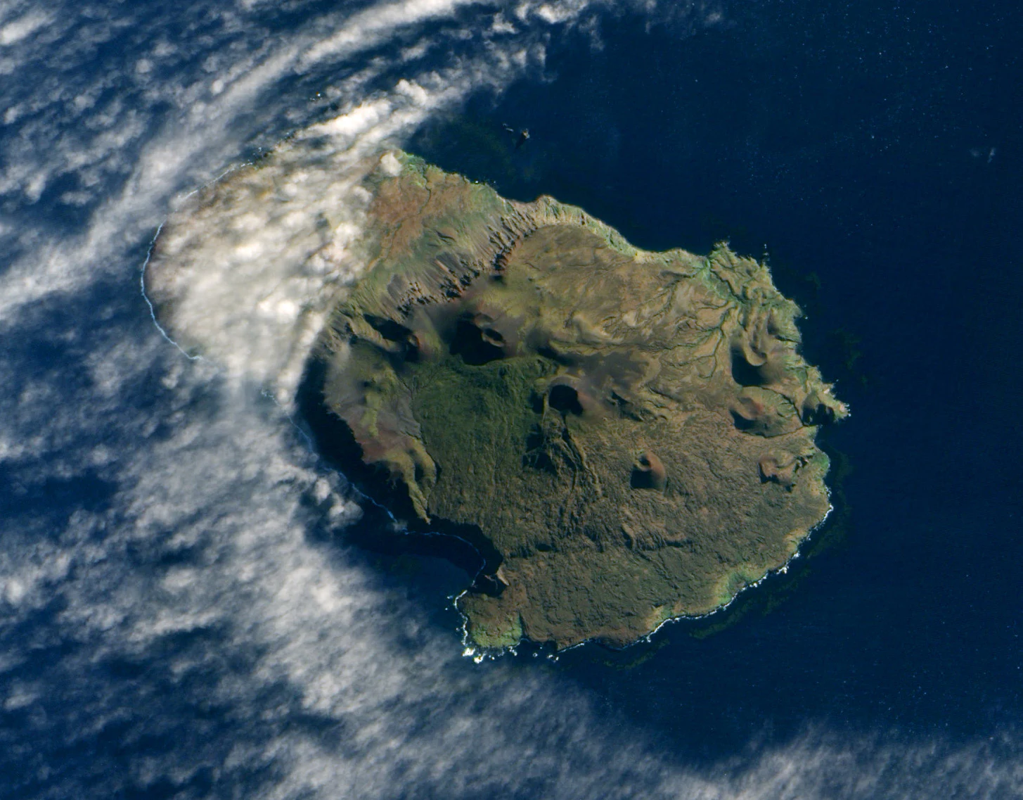
Satellite image from above showing the rugged, volcanic terrain of Prince Edward Island surrounded by ocean and scattered clouds.
Satellite view of Prince Edward Island in the southern Indian Ocean.

Prince Edward Islands history and protected-area timeline

The Prince Edward Islands were first reached by Europeans in 1663, when Barent Barentszoon Lam of the Dutch East India Company landed from the ship Maerseveen and named the islands Dina and Maerseveen. Because their position was misrecorded, they were not reliably relocated by other Dutch sailors. In 1772, the French frigate Le Mascarin under Marc-Joseph Marion du Fresne spent five days trying to land, initially believing the islands to be Antarctica; Marion named them Terre de l'Espérance and Île de la Caverne. The next significant contact came in 1776, when James Cook passed the islands while leaving Cape Town on his third voyage and named them after Prince Edward, the fourth son of King George III.

The nineteenth century brought a destructive sealing era to the islands. The first recorded landing by seal hunters was in 1799 from the ship Sally, and other sealers arrived regularly afterward. Between 1799 and 1913, more than one hundred sealing vessels visited the islands, including seven that were shipwrecked. By about 1810, fur seal populations had been nearly wiped out, and the surrounding waters were also heavily exploited by whalers, with mass illegal whaling continuing into the late twentieth century. Sealing relics, including iron trypots, ruined huts, and inscriptions, still mark sites on both islands.

A series of shipwrecks occurred through the nineteenth and early twentieth centuries, most famously the 1908 loss of the Norwegian vessel Solglimt on Marion Island, whose stranded crew briefly set up a small village on the coast before being rescued. In 1908, the British government granted a guano lease on Marion Island. By the end of the Second World War, the islands had gained new strategic value and Britain agreed to transfer them; South Africa formally annexed them in late 1947 and early 1948, and the annexation was confirmed by the Prince Edward Islands Act, 1948.

Since 1948, the islands have hosted a permanent meteorological and biological research station on Marion Island, initially established on Transvaal Cove on the north-east coast and later rebuilt between 2001 and 2011. In 2003, the South African government designated the islands as a Special Nature Reserve, and in 2013 it declared an enormous marine protected area around them. In 1979, the so-called Vela incident, an unidentified double flash detected by a US satellite in the waters off the islands, became a long-running and controversial topic in discussions of undeclared nuclear testing.

Prince Edward Islands landscape and geographic character

The Prince Edward Islands rise sharply from a deep and turbulent ocean, with dramatic coastlines, high cliffs, and a heavily glacially sculpted interior. Marion Island, the larger of the two, measures about 25 kilometers long and 17 kilometers wide, with a coastline dominated by steep cliffs rising from the sea and a complex interior of hillocks, small lakes, and boggy lowland terrain with sparse vegetation. Mascarin Peak, the highest point on the islands, reaches more than 1,200 meters above sea level and rises from a shield volcano that ascends roughly five thousand meters from the ocean floor.

Prince Edward Island is far smaller, covering only about 46 square kilometers, but is equally dramatic. Its southwestern side is defined by cliffs reaching nearly five hundred meters, while interior peaks such as van Zinderen Bakker Peak rise to more than 670 meters. The terrain is generally rocky and exposed, with offshore features like Ship Rock and Ross Rocks along the northern coast and Boot Rock off Marion Island adding to the ruggedness of the seascape.

The islands sit within the Roaring Forties wind belt, and the landscape shows the persistent influence of wind and weather through its predominantly cliffed shorelines, lack of tall vegetation, and unsteady peat-covered slopes. Glacial and volcanic processes have shaped the current topography, creating a landscape that combines active volcanic origins with the smooth, rolling tones of subantarctic peatlands and tundra.
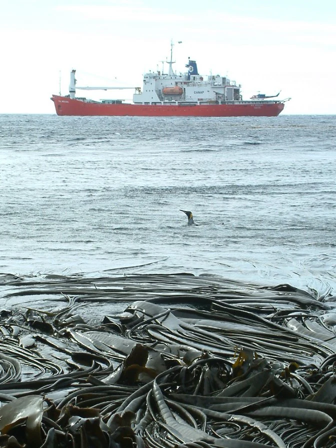
A red research vessel floats on the open ocean behind a thick bed of bull kelp with a king penguin swimming in the middle distance.
The SA Agulhas research vessel moored off the coast of Marion Island, surrounded by bull kelp and a swimming king penguin.

Prince Edward Islands ecosystems, habitats, and plant life

The Prince Edward Islands belong to the Southern Indian Ocean Islands tundra ecoregion, a globally distinctive biome that includes only a small number of subantarctic islands. Because land in the Southern Ocean is extremely scarce, these islands function as ecological refuges for species that cannot survive in purely marine environments. The ecoregion is characterized by a limited but specialized flora, including mosses, lichens, grasses, ferns, cushion plants, and coastal kelp communities, with vegetation kept low and compact by persistent wind and cold.

On land, the islands support only twenty-two native vascular plant species, supplemented by a modest assortment of ferns, clubmosses, and flowering cushion plants. Notable species include Kerguelen cabbage, Antarctic buttercup, and Azorella selago, a key cushion-forming plant. A sedge species, Carex dikei, is endemic to Marion and Prince Edward Island, while at least one other historical species is of uncertain status, with no confirmed records since the late 1960s. Kelp beds line much of the shoreline, providing habitat for invertebrates and serving as a key link between marine and terrestrial ecosystems.

Prince Edward Islands wildlife and species highlights

The Prince Edward Islands are remarkably rich in seabird life given their small land area. The islands are recognized as an Important Bird Area by BirdLife International and support what is estimated to be on the order of five million breeding seabirds and roughly eight million seabirds in total. Five species of albatross breed here, including the wandering albatross and several other threatened or endangered species, alongside fourteen petrel species, four prion species, the Antarctic tern, and the brown skua. Four penguin species also breed on the islands: king penguins, Eastern rockhopper penguins, gentoo penguins, and macaroni penguins.

Marine mammals are equally prominent. Three species of seal breed on the islands: southern elephant seals, Antarctic fur seals, and Subantarctic fur seals. The surrounding waters are visited by orcas, which prey on penguins and seals, as well as larger whales such as southern right whales, humpback whales, and leopard seals, though the local populations of these visitors are reduced compared to the time before sealing and whaling brought significant disturbance. The islands' only native terrestrial animal is the seaweed-eating weevil Palirhoeus eatoni, along with other insects, which play a small but important ecological role.

History has left strong marks on this wildlife. Sealing operations between 1799 and 1913 nearly eradicated the local fur seals, and nineteenth-century and twentieth-century whaling collapsed whale populations across the Southern Ocean. Modern threats include longline fishing for Patagonian toothfish, which poses a significant bycatch risk to seabirds, and invasive species, particularly house mice and, historically, feral cats.

Prince Edward Islands conservation status and protection priorities

The Prince Edward Islands are at the center of one of the most rigorous conservation regimes in the Southern Hemisphere. South Africa declared both Marion Island and Prince Edward Island as Special Nature Reserves under the Environmental Management: Protected Areas Act, and in 2013 it declared a marine protected area covering approximately 180,000 square kilometers of ocean around them, creating one of the largest environmental protection zones on Earth. The islands are also a designated Ramsar Wetland of international importance and an Important Bird Area for their globally significant seabird colonies.

The protected status of the islands restricts human activity to research and conservation management. A small permanent research team studies resident and breeding seabirds, fur seal populations, and the broader subantarctic ecosystem. Research from the islands has also extended into astrophysics, including experiments designed to detect faint radio signatures from the early universe using the islands' uniquely quiet electromagnetic environment.

Invasive species are one of the most pressing conservation concerns. House mice, introduced in the nineteenth century, exploded in numbers after the successful eradication of feral cats and have been documented attacking albatross chicks. Invasive procumbent pearlwort is transforming upland vegetation and is considered effectively beyond control. Planning is underway for future eradication of mice, although the size, elevation, and weather variability of Marion Island make such projects exceptionally challenging.

Prince Edward Islands cultural meaning and human context

The Prince Edward Islands have no permanent population and no Indigenous human history, but their cultural significance is closely tied to the long arc of maritime exploration and exploitation in the Southern Ocean. European contact began with the Dutch East India Company in the seventeenth century and continued with French, British, American, and Norwegian visitors through the sealing and whaling eras. Namesake figures such as Marc-Joseph Marion du Fresne and Prince Edward, Duke of Kent and Strathearn, are reflected in the islands' names, while the surviving sealing relics, shipwrecks, and inscriptions bear witness to more than two centuries of often destructive human presence.

The modern cultural identity of the islands is strongly scientific. The South African National Antarctic Programme research station on Marion Island supports a small, rotating community of meteorologists, biologists, and other researchers, and the islands have become a globally recognized reference site for subantarctic ecology, atmospheric monitoring, and even astronomy experiments that exploit their remote, low-interference environment.

Top sights and standout views in Prince Edward Islands

The Prince Edward Islands combine an active volcanic island setting in the Roaring Forties wind belt with an unusually intact subantarctic ecosystem, despite centuries of sealing and whaling pressure. Their cliffs, bogs, and Mascarin Peak summit form a dramatic backdrop to internationally important seabird colonies and breeding seal populations, while the surrounding Marine Protected Area places the islands at the heart of one of the largest ocean conservation efforts on Earth.

A distinctive feature is the islands' dual role as both a Ramsar Wetland and an Important Bird Area, supporting multiple threatened albatross species alongside penguins, petrels, and prions. The combination of strict special nature reserve status, active scientific research, and a tightly restricted human presence makes the Prince Edward Islands a benchmark example of modern subantarctic conservation.

Best time to visit Prince Edward Islands

Because the Prince Edward Islands are uninhabited apart from a small research team and access is restricted to scientific and conservation purposes, seasonal visitation by the public is effectively not part of the park's identity. The climate further limits the character of any visit: summer and winter are fairly similar, with cold winds, frequent precipitation, and the possibility of snow or frost in any month. Mean summer temperatures are only modestly higher than winter ones, and the islands are famous for their almost constant cloud cover.

If interpreted in ecological or research terms rather than tourism terms, the period of mildest conditions and slightly higher sunshine hours falls in the local summer months of December through February, when mean temperatures are highest and weather is least severe. However, wildlife viewing, scientific fieldwork, and atmospheric monitoring continue year-round, and the islands' character remains one of relentless wind, cool temperatures, and oceanic weather regardless of season.


Monthly climate preview

Long-term monthly temperature averages and precipitation patterns for Prince Edward Islands

Prince Edward Islands Climate Normals, Annual Temperature and Precipitation Rhythm

Representative coordinate records show measured annual temperature ranges alongside steady monthly precipitation rates from 1991 to 2020. Reviewing the complete twelve-month climatology profile reveals detailed thermal shifts and long-term weather norms across the protected landscape.
Annual mean6 °C
4 °C7 °C
Jan
Feb
Mar
Apr
May
Jun
Jul
Aug
Sep
Oct
Nov
Dec
Warmest month
February

7.4 °C

Coolest month
September

3.9 °C

Wettest month
April

3.8 mm/day

Driest month
November

2.8 mm/day

Park location guide

Geography guide, regional context, and park location map for Prince Edward Islands

Prince Edward Islands park geography, regions, and map view in South Africa

Understand where Prince Edward Islands sits in South Africa through a broader geographic reading of the surrounding landscape, nearby location context, and its mapped position within the national park landscape.

How Prince Edward Islands fits into South Africa

South Africa is the southernmost country in Africa, spanning 1.22 million km² with a population of over 63 million. The country operates with three capital cities, Pretoria (executive), Cape Town (legislative), and Bloemfontein (judicial), and is renowned for its biodiversity, national parks, and multicultural society.

Wider geography shaping Prince Edward Islands in South Africa

South Africa occupies the southernmost region of Africa, with coastline along both the Atlantic Ocean to the west and the Indian Ocean to the east. The interior features elevated plateaus including the Highveld, with the Drakensberg escarpment marking the eastern highlands. The country shares borders with Namibia, Botswana, Zimbabwe, Mozambique, Eswatini, and Lesotho.

Map view of Prince Edward Islands

Use this park location map to pinpoint Prince Edward Islands in South Africa, understand its exact geographic position, and read its mapped placement within the surrounding landscape more clearly.

Pigeon | © OpenStreetMap contributors

Location context for Prince Edward Islands

Western Cape
Recorded earthquake history

Explore the Historical Earthquake Catalogue for the Prince Edward Islands

Review the detailed timeline of seismic events recorded in the vicinity of the Prince Edward Islands. This MoriAtlas catalogue provides structured data on event magnitude, depth, and epicentre distance to assist in geographic and historical research across the region.

Prince Edward Islands Earthquake History

Catalogued events

2 events

Strongest magnitude

Magnitude 5.9

Most recent event

Sep 26, 2000

This history includes earthquakes recorded inside the park or within 50 km of its borders

Visual exploration of subantarctic volcanic terrain and coastal habitats

Prince Edward Islands Photos and Protected Landscape Scenery

Visual documentation captures the dramatic volcanic terrain, storm-swept coastlines, and fragile tundra habitats defining Prince Edward Islands. Detailed photography reveals the rugged topography of Marion Island and the remote ecological character of this southern marine reserve.

Satellite image from above showing the rugged, volcanic terrain of Prince Edward Island surrounded by ocean and scattered clouds.

Satellite image showing the circular, volcanic island of Marion Island surrounded by the dark blue Indian Ocean.

A red research vessel floats on the open ocean behind a thick bed of bull kelp with a king penguin swimming in the middle distance.

Park atlas

Compare subantarctic islands and marine protected landscapes across the region

Explore Other Parks Near Prince Edward Islands and Protected Areas

Browse related protected areas and remote marine reserves that share similar ecological traits with Prince Edward Islands. Comparing these isolated habitats provides deeper regional context on southern ocean conservation and volcanic island topography.
National parkEastern Cape
1,719 km away#1 closest

Northwest

Addo Elephant National Park: South African National Park with Diverse Protected Landscapes

Explore its geographic context and unique Big Seven megafauna habitats.

Addo Elephant National Park is a crucial protected landscape within South Africa's Eastern Cape, covering approximately 1,640 square kilometers of varied terrain including karoo plains, coastal dunes, and marine protected areas. Its identity is deeply tied to the successful recovery of elephant populations and its distinction as the only African national park where all Big Seven megafauna can be observed in their natural surroundings. Discover the park's geographic spread, landscape diversity, and its role as a premier conservation area.

Area
1,640 km²
Established
1931
IUCN
II
Visitors
305.5K annual
Wildlife reserveEastern Cape
About 1,741 km away#2 closest

Northwest

Inkwenkwezi Private Game Reserve: Wildlife Reserve and Regional Landscape Geography

A protected multi-biome territory in South Africa's Eastern Cape region

Inkwenkwezi Private Game Reserve represents a critical study in compressed ecological diversity. Within its 4,500-hectare boundary, the property demonstrates the transition between coastal Wild Coast influences and inland forests. This overview details the reserve's unique biome convergence and its place within the broader protected geography of the Eastern Cape, providing insight into the land use and wildlife habitat structure.

Area
45 km²
Established
1983
Access
Access unknown
Scope
Terrestrial
Nature reserveEastern Cape
About 1,768 km away#3 closest

Northwest

Dwesa Nature Reserve and Wild Coast Protected Landscapes in Eastern Cape

Coastal forest, marine protection, and rugged river valley topography

Dwesa Nature Reserve protects a distinctive interface between land and sea, featuring shaded indigenous forests that descend into a series of open coves and cliffs along the Indian Ocean. This geographic study reveals how varied habitats from woodland to estuary are preserved within a single unit in South Africa, providing significant insights into regional biodiversity and coastal land management.

Area
54.5 km²
Established
1975
Relief
Lowland
Access
Access unknown
Wildlife reserveEastern Cape
About 1,770 km away#4 closest

Northwest

Shamwari Game Reserve: An Atlas View of Restored Bushveld and Conservation Landscapes

Examining protected terrain within South Africa's Eastern Cape

Shamwari Game Reserve occupies approximately 250 square kilometers of restored Eastern Cape terrain. As a focal point of the Indalo Protected Environment, the reserve provides a structured habitat for diverse wildlife species and represents a significant case study in regional land reclamation and conservation mapping.

Area
250 km²
Established
1992
Relief
Upland
Scope
Terrestrial
Nature reserveEastern Cape
About 1,782 km away#5 closest

Northwest

Great Fish River Nature Reserve: Mapping Protected Areas in the Eastern Cape of South Africa

A consolidated network of river-valley terrain and subtropical thicket ecosystems.

Spanning over 45,000 hectares, this reserve captures the essence of the Eastern Cape's dissected landscape. The protected area is defined by the Great Fish River and a series of steep, dramatic cliffs that separate distinct ecological basins. This atlas entry focuses on the reserve's unique combination of historical boundaries and its role in maintaining habitat continuity along the region's main river valley.

Area
450 km²
Established
1994
Relief
Upland
Climate
Subtropical
National parkSouth Africa
1,805 km away#6 closest

Northwest

Garden Route National Park: South Africa's Protected Landscape and Forest Atlas

Explore indigenous forests, coastal cliffs, and lake systems.

Garden Route National Park is a key national park in South Africa, celebrated for its rich indigenous forests and dramatic coastline. As a protected landscape, it offers a unique geographic profile, blending ancient woodlands with rugged coastal terrain and interconnected lake systems. This page serves as an atlas entry, detailing the park's spatial extent and its significance as a conservation area within the broader geography of South Africa.

Area
1,210 km²
Established
2009
IUCN
II
Relief
Mixed relief
Nature reserveEastern Cape Province
About 1,827 km away#7 closest

Northwest

Mpofu Nature Reserve: Mapping the Ecological Diversity of the Amatole Mountains

Protected escarpment terrain and South African biome transitions

Located in the Eastern Cape, Mpofu Nature Reserve is a significant protected landscape known for the meeting of Grassland, Forest, and Albany Thicket biomes. The terrain ranges from low valley floors to high escarpment plateaus, providing a complex habitat for diverse mammals and endemic flora in a malaria-free setting.

Area
75 km²
Established
1985
Relief
Mountain
Climate
Subtropical
A soft watercolor painting depicting a coastal landscape with a waterfall cascading toward the ocean, surrounded by rolling hills and greenery.
Nature reserveEastern Cape
1,828 km away#8 closest

Northwest

Mkhambathi Nature Reserve: A Coastal Protected Area in the Eastern Cape, South Africa

Endemic flora, forested river ravines, and Ramsar-listed wetland geography.

Mkhambathi Nature Reserve protects a striking coastal corridor along the Wild Coast. The area is characterized by rolling grasslands, indigenous swamp forests, and dramatic river incisions. This Ramsar wetland site supports rare floral endemism and critical bird habitats, serving as a primary study site for understanding the unique biological connectivity between South African coastal forests and marine environments.

Area
77.2 km²
Established
2009

Common questions about visiting, size, designation, and location context for Prince Edward Islands

Prince Edward Islands FAQs for park facts, access, geography, and protected area context

Find quick answers about Prince Edward Islands, including protected-area facts, park geography, trail and visitor context, and how the park fits into its surrounding country and regional landscape.
MoriAtlas Explorer

Continue Your Protected Areas Search Across the Global Atlas

Deepen your exploration by continuing the structured search for national parks and protected areas worldwide. Utilize the comprehensive filtering capabilities to compare different conservation landscapes and refine your understanding of global park geography. Discover more about the distribution and characteristics of protected natural areas.

Global natural geography