
Mori Atlas logo
Protected landscapePřírodní park Baba

Trace the topography and natural terrain of this six-kilometer wooded ridge near Brno

Přírodní park Baba: A Comprehensive Protected Landscape and Forested Ridge Atlas for Czechia

Přírodní park Baba spans an expansive six-kilometer forested ridge north of Brno, acting as a crucial green buffer within the Czech landscape. This protected area features a mosaic of century-old sessile oak woodlands, open meadows, and diverse bird habitats centered along the Bobravská vrchovina highland. Beyond its ecological significance, the site preserves unique historical boundary stones that delineate centuries of land division, making it a distinct study of regional geography and conservation.

oak forestforested ridgeprotected landscapeurban-proximate naturemeadowsorchids
A flat vector-style illustration showing a winding river through a valley with forested hills, a waterfall cascading down a cliff face on the left, and a soft sunset sky.

Přírodní park Baba

Protected landscape

Park overview

Structured park overview, official facts, and landscape profile for Přírodní park Baba

Přírodní park Baba park facts, protected area profile, and essential visitor context

Review the core facts for Přírodní park Baba, including designation, size, terrain, visitor scale, habitats, and operating context in one park-focused overview.

About Přírodní park Baba

Přírodní park Baba is a compact but ecologically rich protected area in the South Moravian Region of the Czech Republic, positioned on a forested ridge that forms the northern edge of greater Brno. The park covers about 8.89 square kilometers and lies predominantly in the Brno-venkov district, with a smaller portion within the Brno-město district. Its territorial footprint spans the cadastres of Kuřim, Jinačovice, Brno-Komín, Brno-Řečkovice, and Brno-Medlánky, with Kuřim holding the largest share of the protected area.

The defining feature of the park is an approximately six-kilometer long, forested elevation that runs south to north through the Bobravská vrchovina. Along this ridge, a sequence of named hills shapes the local topography: Bosně at 365 meters, Malá Baba at 399 meters, Velká Baba at 446 meters, Chochola at 446 meters, Sychrov at 463 meters (the highest point in the park), and Kuřimská hora at 435 meters. Between the Brno districts of Bystrc, Komín, and Medlánky to the south and the town of Kuřim to the north, the ridge creates a continuous green corridor that separates suburban neighborhoods from the open countryside beyond.

Ecologically, the park is anchored in its century-old oak stands, especially sessile oak, supplemented by spruce, Scots pine, beech, hornbeam, and birch. The character of the forest is unusually bright and airy, with light reaching the forest floor and supporting a diverse understory of shrubs and herbaceous plants. Open clearings and meadows are interspersed through the woodland, providing habitat for rarer plant species and supporting natural regeneration of oak. Small-scale, ecologically managed timber harvesting leaves woody debris in place to decompose naturally, a feature that contributes to the site's biodiversity.

Baba also carries a clear cultural-historical dimension. Five preserved historical boundary stones stand along the yellow-marked hiking trail, marking the old cadastral boundary between Jinačovice and Brno, with one additional stone marking the boundary between Brno-Ivanovice and Jinačovice to the east. These stones preserve an old territorial memory within a landscape that is otherwise valued primarily for its natural character.

Quick facts and research context for Přírodní park Baba

Přírodní park Baba is a protected natural area of about 8.89 km² located in the Bobravská vrchovina highland on the northern outskirts of Brno, Czech Republic. The park straddles the Brno-venkov and Brno-město districts, with its administrative extent spread across five cadastres headed by Kuřim and Jinačovice. It was designated in 1990–1991, and its highest point, Sychrov, reaches 463 meters above sea level. The protected territory follows an approximately six-kilometer forested ridge whose character is defined by old oak stands, mixed broadleaf and conifer forest, and scattered meadows.

Protection and recognition

Documented management scope and official designation records for the protected area

Přírodní park Baba Protection Status and Terrestrial Conservation Data

Terrestrial conservation records for Přírodní park Baba outline the documented protection status and regional designation framework. Structured database entries organize available administrative details and international recognition metrics for the natural landscape.

Protection details

Protection scope
Terrestrial
Transboundary protection
No
Park context

Deeper park guide and search-rich context for Přírodní park Baba

Přírodní park Baba history, landscape, wildlife, and travel context

Explore Přírodní park Baba through its history, landscape character, ecosystems, wildlife, conservation priorities, cultural context, and seasonal travel timing in a structured park guide built for atlas discovery and search intent.

Why Přírodní park Baba stands out

Přírodní park Baba is recognized for its remarkable old oak forests, particularly stands of sessile oak that have reached a century or more of age, set within a long forested ridge just outside Brno. The park is also known for its rich flora supporting numerous rare and protected species, including several orchid species and the golden-headed lily. Historical boundary stones along the ridge add a layer of cultural significance to what is otherwise a strongly ecological protected landscape.
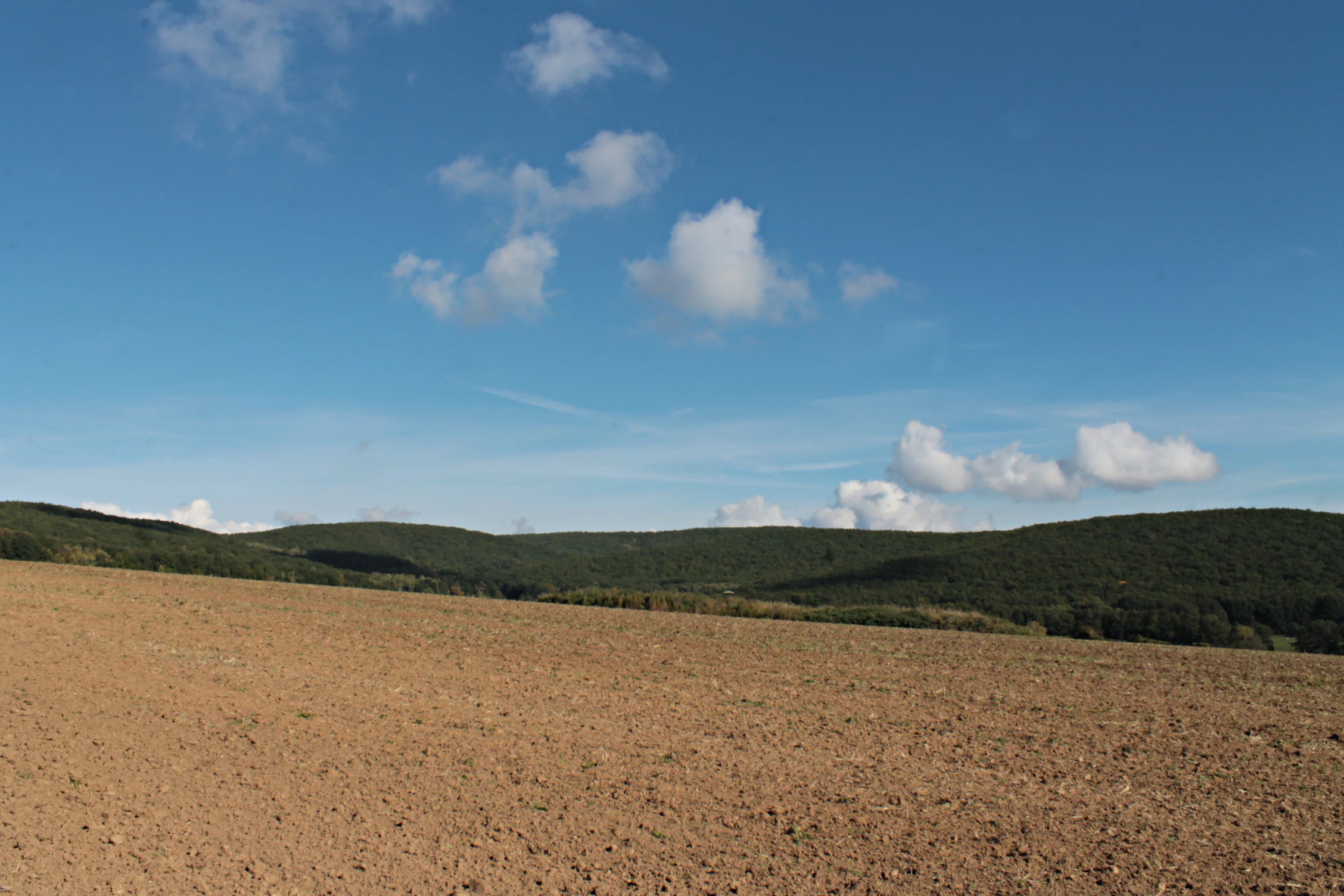
A wide shot showing a large, freshly plowed brown field in the foreground, leading up to rolling, dark-green forested hills under a clear blue sky with light clouds.
A view across a plowed field toward the forested ridgeline of Baba Nature Park.

Přírodní park Baba history and protected-area timeline

Přírodní park Baba was formally designated as a protected natural area in 1990 and 1991, following the wave of conservation initiatives that followed the political changes in Czechoslovakia at the end of the 1980s. The protected status was applied to an already established wooded ridge north of Brno that had long functioned as a green boundary between the city and the surrounding villages of Kuřim and Jinačovice.

The cultural landscape of the ridge is older than its protected designation. Historical cadastral boundary stones, several of which are preserved along the yellow-marked hiking trail crossing the park today, once marked territorial divisions between Jinačovice and Brno and between Jinačovice and Brno-Ivanovice. The presence of these stones indicates that the area has been a meaningful landscape boundary for a long time, long before formal environmental protection was applied to it.

In the decades since its declaration, the park has been managed with attention to maintaining the existing ecological character. Cutting is done through selective thinning rather than large-scale clearcutting, and removed wood is partly left on site to undergo natural decomposition, supporting soil organisms and overall forest health.

Přírodní park Baba landscape and geographic character

The landscape of Přírodní park Baba is centered on a long, wooded ridge that extends roughly six kilometers south to north along the Bobravská vrchovina highland. This ridge creates a clear topographical spine between the southern Brno neighborhoods of Bystrc, Komín, and Medlánky and the northern town of Kuřim.

A series of named hills runs along the ridge in sequence, beginning with Bosně at 365 meters in the south and rising through Malá Baba at 399 meters, Velká Baba at 446 meters, Chochola at 446 meters, Sychrov at 463 meters (the highest point within the protected area), and Kuřimská hora at 435 meters in the north. The terrain between these elevations consists of forested slopes interspersed with open meadows and small clearings, creating a mixed mosaic of woodland and grassland.

The underlying geology of the ridge is composed mainly of Paleozoic diorite and granodiorite, which weather into moderately moist, humus-rich soils with a smaller clay component. This geological foundation, combined with the relatively stable local temperatures, supports the deep-rooted, century-old oak forests that characterize much of the park.
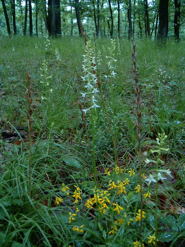
A group of slender, white-flowered Lesser butterfly orchids rising above small yellow wildflowers in a forested park setting.
A cluster of Lesser butterfly orchids blooming in the forest floor at Přírodní park Baba.

Přírodní park Baba ecosystems, habitats, and plant life

The ecological character of Přírodní park Baba is defined by its long-established oak forests, with sessile oak forming the backbone of the canopy. These old stands, some of them roughly a century in age, are accompanied by spruce, Scots pine, beech, hornbeam, and birch, producing a mixed forest structure unusual for lowland Moravia. Continued natural regeneration of oak, particularly in clearings, anchors the park's long-term forest character.

The forest is unusually bright and airy, allowing light to reach the forest floor. This openness supports a varied shrub and herb layer, including elder, bramble, lily of the valley, wood anemone, ashweed, comfrey, lungwort, asarabacca, several orchid species, and a number of rarer flowering plants such as golden-headed lily, mezereon, large yellow foxglove, upright clematis, balm-leaved melittis, and purple cyclamen. The combination of open light, oak litter, and varied soil moisture produces a notably rich understory.

Open meadows and clearings interwoven with the woodland add a second ecological layer. Natural processes within the soil, the edaphon, are marked as particularly rich, contributing to the overall ecological complexity of the site. Selective timber management and the practice of leaving part of the removed wood on site to decompose further enhance the structural diversity of the forest floor.
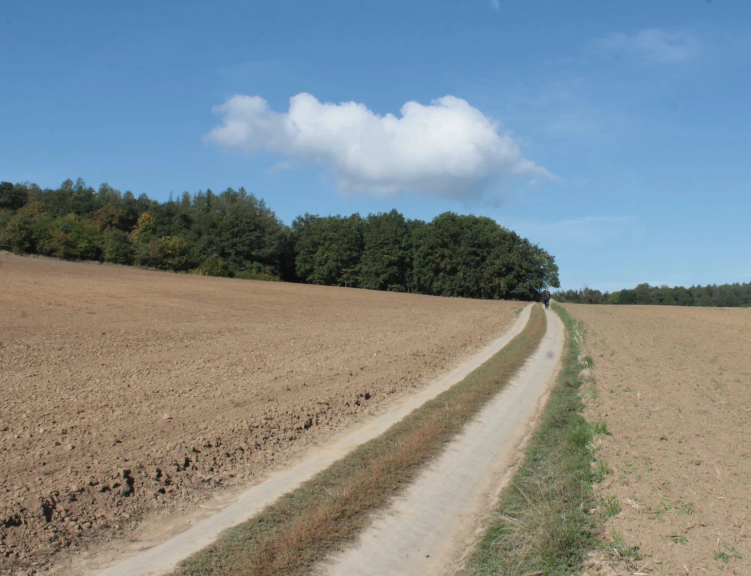
A dirt trail winds through brown plowed fields toward a line of green forest under a blue sky with one small cloud.
A rural dirt track passing through agricultural fields towards the forested ridge of Prirodni park Baba.

Přírodní park Baba wildlife and species highlights

Přírodní park Baba supports a varied animal community shaped by its mixed forest, meadows, and open clearings. Reptiles such as the green lizard and the smooth snake are recorded within the park, while birdlife during the nesting season includes more than 50 documented species.

Among nesting birds, several species of conservation interest are present. A few pairs of golden oriole and black woodpecker breed in the area, alongside middle spotted woodpecker, spotted flycatcher, Eurasian wryneck, and wood pipit, with red-backed shrike nesting at forest edges. Regular breeding raptors include common buzzard, Eurasian sparrowhawk, and northern goshawk, while tawny owl is also recorded. Raven is among the larger species observed here.

The invertebrate fauna is also notable. Beetles such as the common sexton beetle, lily beetle, several longhorn and click beetles, and various ground beetles are documented, alongside butterflies including the ringlet and a small fritillary species. Among spiders, the woodland huntsman has been recorded, while in winter a ground-dwelling fungus-feeding species has been observed among the leaf litter and soil organisms.
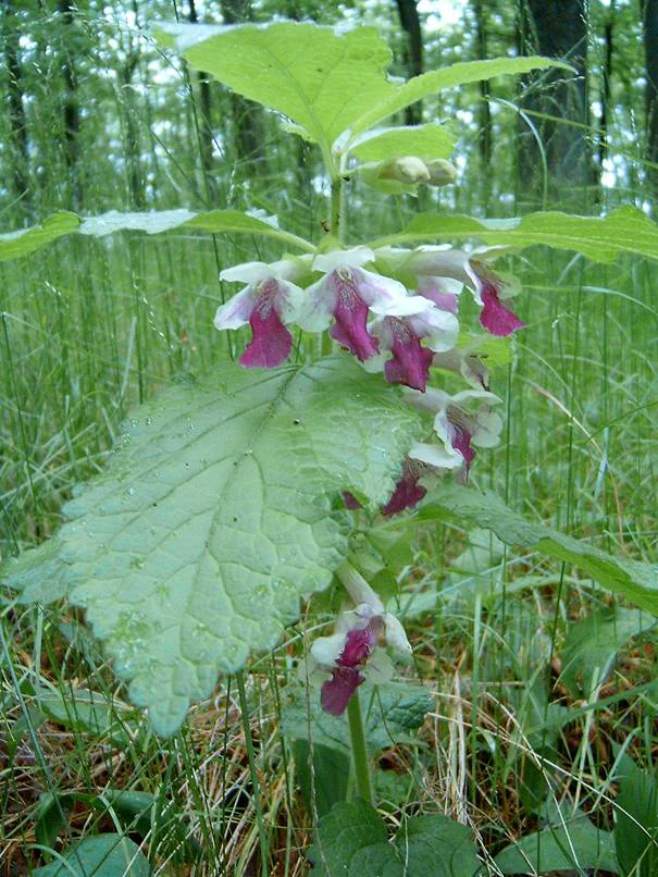
A close-up view of a Melittis melissophyllum plant with distinct white and magenta flowers and broad, textured green leaves, situated in a grassy forest floor setting.
A Melittis melissophyllum plant in bloom within the forest undergrowth of Přírodní park Baba.

Přírodní park Baba conservation status and protection priorities

Přírodní park Baba was designated as a protected natural area in 1990–1991 in recognition of its old oak forests, mixed woodland, and supporting flora and fauna. The park's conservation value rests particularly on its centuries-old sessile oak stands, an unusual feature in the regional landscape, and on the diversity of rare and protected plant species that grow within them.

The site protects a continuous ridge of forest and meadows that functions as an important ecological corridor between the city of Brno and the wider countryside to the north. By maintaining natural regeneration of oak, selective forestry practices, and the retention of woody debris for natural decomposition, the management approach supports long-term ecological continuity rather than short-term timber yield.

The combination of bright, airy forest conditions, varied soil types over Paleozoic diorite and granodiorite bedrock, and interspersed meadows creates conditions for high plant diversity, including several protected orchid species. The park's conservation role is therefore both in preserving an uncommon local forest type and in safeguarding a habitat mosaic that supports a rich array of plant, insect, and bird species.

Přírodní park Baba cultural meaning and human context

Beyond its natural value, Přírodní park Baba carries a clear cultural-historical dimension visible along its trails. Five preserved historical boundary stones stand along the yellow-marked hiking path, marking the old cadastral boundary between the village of Jinačovice and the lands of Brno, with one additional stone marking the boundary between the Brno district of Ivanovice and Jinačovice to the east.

These stones reflect the long history of the ridge as a meaningful territorial edge between the city and surrounding rural communities. Today they provide a tangible reminder that the forested ridge, although now primarily valued for its ecology, has functioned for centuries as a quiet boundary between different administrative and cultural units of the Brno region.
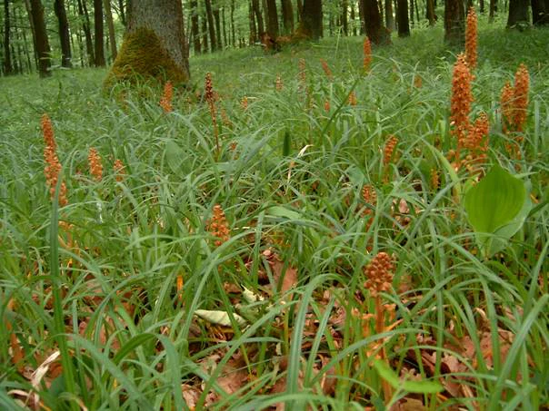
Several brown, stalked bird's-nest orchids emerging from green grass on a shaded forest floor.
Clusters of Neottia nidus-avis growing on the forest floor in Přírodní park Baba.

Top sights and standout views in Přírodní park Baba

Přírodní park Baba offers several distinct qualities that set it apart. The park's defining feature is its century-old stands of sessile oak, a rare feature in the surrounding South Moravian lowlands, complemented by mixed broadleaf and conifer species. A continuous mosaic of forest and open meadows creates unusually light forest conditions that support a rare flora, including golden-headed lily, mezereon, upright clematis, and several protected orchid species.

The nesting bird community, with more than 50 species recorded during the breeding season and a regular presence of golden oriole, black woodpecker, and northern goshawk, adds strong wildlife interest. The five historical boundary stones along the main trail give the landscape a cultural layer rarely found in a small urban-proximate protected area, while the elongated six-kilometer ridge itself forms a clear topographical backbone of the park.
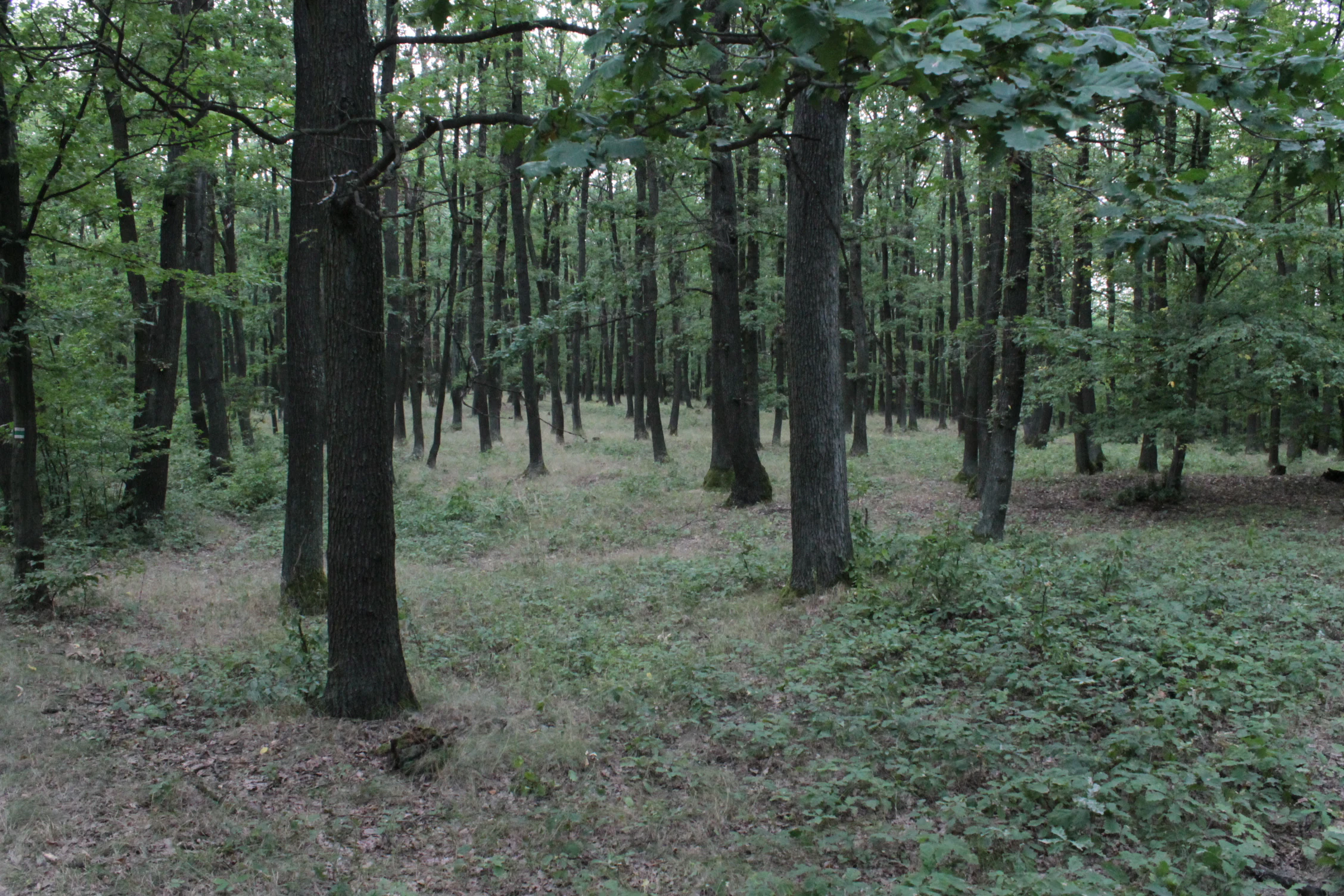
A dense, mature deciduous forest with slender tree trunks, green canopy, and a leaf-littered ground in a nature park.
A forested area within the Přírodní park Baba landscape.

Best time to visit Přírodní park Baba

Přírodní park Baba is most rewarding in late spring and early summer, when the open meadows and forest clearings host peak flowering of species such as golden-headed lily, wood anemone, lungwort, and several orchids, and when breeding birds, including golden oriole and woodpeckers, are most active. The bright, airy character of the oak forest makes these months especially favorable for observing both flora and birdlife.

Autumn brings a quieter character, with warm forest colors and good conditions for mushroom-related exploration and general hiking, while the open ridges remain accessible throughout the year. Winter visits offer a different perspective on the ridge's structure, with bare canopies opening up views across the hills and into the surrounding landscape.

Monthly climate preview

Long-term representative averages for monthly temperature and precipitation rhythm

Přírodní park Baba Climate Normals and Annual Temperature Patterns

Representative coordinates record long-term average monthly temperatures spanning from sub-zero winter minimums to warm summer maximums alongside consistent precipitation rhythms. Reviewing the complete twelve-month climatology profile provides deeper analytical context for annual atmospheric variations across the protected landscape.
Annual mean7 °C
-4 °C18 °C
Jan-4°
Feb-2°
Mar
Apr
May12°
Jun16°
Jul18°
Aug18°
Sep13°
Oct
Nov
Dec-3°
Warmest month
July

18.5 °C

Coolest month
January

-3.8 °C

Wettest month
July

2.8 mm/day

Driest month
February

1.2 mm/day

Park location guide

Geography guide, regional context, and park location map for Přírodní park Baba

Přírodní park Baba park geography, regions, and map view in Czechia

Understand where Přírodní park Baba sits in Czechia through a broader geographic reading of the surrounding landscape, nearby location context, and its mapped position within the national park landscape.

How Přírodní park Baba fits into Czechia

Czech Republic is a landlocked Central European country with a population of approximately 10.9 million people. The nation was established as an independent state on January 1, 1993, following the dissolution of Czechoslovakia. Its capital and largest city is Prague, with other major urban centers including Brno, Ostrava, Plzeň, and Liberec.

Wider geography shaping Přírodní park Baba in Czechia

The Czech Republic is a landlocked country in Central Europe. It is bordered by Germany to the west, Austria to the south, Poland to the northeast, and Slovakia to the southeast. The landscape is predominantly hilly, with the territory covering 78,871 square kilometers.

Map view of Přírodní park Baba

Use this park location map to pinpoint Přírodní park Baba in Czechia, understand its exact geographic position, and read its mapped placement within the surrounding landscape more clearly.

Pigeon | © OpenStreetMap contributors

Visual reference guide to forested ridges, old oak habitats, and protected terrain.

Přírodní park Baba Photos and Landscape Scenery Explorer

Visual documentation captures the forested ridge, century-old oak stands, and open meadow mosaic defining Přírodní park Baba. Photographic coverage reveals the topographical character of the highland terrain and rare plant habitats across the protected area.

A wide shot showing a large, freshly plowed brown field in the foreground, leading up to rolling, dark-green forested hills under a clear blue sky with light clouds.

A close-up photograph of a pink, spotted Turk's cap lily flower in bloom, with a blurred green forest background.

A group of slender, white-flowered Lesser butterfly orchids rising above small yellow wildflowers in a forested park setting.

A dirt trail winds through brown plowed fields toward a line of green forest under a blue sky with one small cloud.

A close-up view of a Melittis melissophyllum plant with distinct white and magenta flowers and broad, textured green leaves, situated in a grassy forest floor setting.

Close-up of a small white flower with slender, spreading petals and a central structure, set against a soft green background.

Several brown, stalked bird's-nest orchids emerging from green grass on a shaded forest floor.

A dense, mature deciduous forest with slender tree trunks, green canopy, and a leaf-littered ground in a nature park.

A wooden hiking trail marker post with multiple signs stands at the edge of a dirt forest path, with two hikers walking away in the distance.

Park atlas

Compare nearby forested ridges, oak woodlands, and regional conservation zones.

Other Parks Like Přírodní Park Baba and Protected Areas in the Surrounding Region

Browsing other parks near Přírodní park Baba reveals connected highland terrain, wooded ridges, and protected landscapes across the surrounding region. Extending the geographic comparison helps travelers trace shared ecological traits, regional elevation patterns, and comparable nature reserves.
A soft watercolor painting showing a rolling landscape with hills, scattered trees, and rocky outcrops, rendered in pastel greens and pinks.
Natural monumentBrno
About 2.9 km away#1 closest

Southeast

Medlánecká skalka Natural Monument: Mapped Protected Landscapes and Geography in Brno

A rare urban-adjacent steppe and rocky habitat site

Medlánecká skalka is a protected natural monument located in the Medlánky district of Brno, Czech Republic. Spanning a small but significant rocky slope, this site preserves thermophilous dry-grassland communities and essential habitats for rare flora like the Pulsatilla grandis. Its unique topography and skeletal soil composition make it an important geographic reference point for understanding steppe-like ecosystems in the South Moravian region.

Area
0.003 km²
Established
1999
IUCN
IV
Relief
Upland
A horizontal watercolor painting showing rolling green hills with small patches of trees under a soft, pale sky.
Natural monumentJihomoravský kraj
About 3.6 km away#2 closest

Southeast

Medlánecké kopce Natural Monument: Exploring Protected Steppe Habitats in Northern Brno

A rare mosaic of dry grasslands and rocky outcrops in Jihomoravský kraj

Medlánecké kopce preserves a critical landscape of thermophilic flora and insect communities on the edge of the Brno basin. The site is noted for its xerothermic vegetation, including the large-flowered pasqueflower, which thrives on its unique metabasite and loess soil composition. This protected area offers a look at how specialized steppe ecosystems persist within a heavily developed regional environment.

Area
0.118 km²
Established
1988
IUCN
IV
Relief
Upland
Natural monumentJihomoravský kraj
About 3.8 km away#3 closest

Southwest

Skalky u Přehrady: Protected Natural Monument and Mapped Landscape in Jihomoravský kraj

Ecologically significant forest steppe and river gorge terrain

Skalky u Přehrady is a protected natural monument characterized by its rugged diorite cliffs and diverse plant communities. The site serves as a compact example of forest steppe mosaic situated along the Svratka River, offering significant insight into the regional geography and conservation status of rocky slopes within the South Moravian territory.

Area
0.013 km²
Established
1989
IUCN
IV
Relief
Upland
Natural monumentJihomoravský kraj
About 4.5 km away#4 closest

East

Soběšické rybníčky Natural Monument: A Detailed Geographic Atlas of the Jihomoravský kraj Forest Ponds

Mapping the protected wetland terrain and amphibian breeding landscapes of central Moravia.

Explore the geographic and conservation profile of Soběšické rybníčky, a protected forest monument in the Czech Republic. The site represents a vital wetland network that maintains stable amphibian populations within a dense, shaded valley setting of the Soběšice Highlands, offering a focused look at small-scale protected landscape management.

Area
0.012 km²
Established
1987
IUCN
IV
Relief
Upland
A soft watercolor illustration showing a landscape with rolling hills in the background, a cluster of green trees, and a rocky outcrop on the right side.
Natural monumentJihomoravský kraj
About 6.3 km away#5 closest

West

Na Skalách Natural Monument: A Protected Limestone Landscape in the South Moravian Highlands

Geographic study of relict oak woodland and cliffside terrain.

Na Skalách stands as a vital natural monument within Jihomoravský kraj, preserving a steep, south-facing limestone slope along the Svratka River gorge. This compact area offers a window into thermophilic oak forest communities and calcareous rock vegetation, showcasing high botanical value and geological diversity despite its small surface area.

Area
0.01 km²
Established
1991
IUCN
IV
Relief
Upland
Nature reserveJihomoravský kraj
About 11 km away#6 closest

Southeast

Velká Klajdovka Nature Reserve: Steppe and Forest-Steppe Landscape in Jihomoravský Kraj

Ecologically rich protected limestone slopes and terrain near Brno

Velká Klajdovka is a protected natural monument distinguished by its high-value thermophilic vegetation and complex soil structures. Located on the flank of the Hády massif, the reserve offers a unique study of forest-steppe mosaics, rare entomological diversity, and dry oak woodlands that thrive on the boundary of varied geological substrates.

Area
0.09 km²
Established
1988
IUCN
IV
Relief
Upland
Protected landscapeBrno-venkov District
About 12 km away#7 closest

West

Přírodní park Údolí Bílého potoka: Protected Landscape in the South Moravian Region

Forested stream valley geography and upland terrain mapping

This protected area centers on the deep, forested valley of the Bílý potok stream. It features a rich mosaic of beech-fir and oak-pine forests on rocky slopes, representing a significant ecological corridor in the agricultural landscape northwest of Brno within the Brno-venkov District.

Area
40.46 km²
Established
1978
Relief
Upland
Climate
Temperate
Watercolor illustration of a karst landscape featuring hills, a lake, and cave-like rock formations with green vegetation
Protected landscapeSouth Moravian Region
About 14 km away#8 closest

East

Moravian Karst Protected Landscape: Detailed Geographic and Cave System Atlas

Mapped protected boundaries and karst phenomena in the South Moravian Region.

Moravian Karst, designated a Protected Landscape Area, offers a profound look into complex karst geology within the South Moravian Region. This entry within MoriAtlas facilitates a structured discovery of its approximately 92 square kilometers, featuring an intricate network of over 1,100 caves and gorges. Users can explore the mapped extent of this geological treasure, understand its relationship with the surrounding regional geography, and appreciate the unique formations sculpted by underground water systems, including the iconic Macocha Abyss.

Area
92 km²
IUCN
V
Scope
Terrestrial
Water
Minor water

Common questions about visiting, size, designation, and location context for Přírodní park Baba

Přírodní park Baba FAQs for park facts, access, geography, and protected area context

Find quick answers about Přírodní park Baba, including protected-area facts, park geography, trail and visitor context, and how the park fits into its surrounding country and regional landscape.
MoriAtlas Explorer

Continue Your Protected Areas Search Across the Global Atlas

Deepen your exploration by continuing the structured search for national parks and protected areas worldwide. Utilize the comprehensive filtering capabilities to compare different conservation landscapes and refine your understanding of global park geography. Discover more about the distribution and characteristics of protected natural areas.

Global natural geography