
Mori Atlas logo
Protected landscapePřírodní park Říčky

Discover the intricate network of stream valleys, alluvial meadows, and diverse forest habitats.

Přírodní park Říčky: A Protected Landscape within the Drahanská vrchovina Highlands of Czechia

Přírodní park Říčky serves as a significant protected landscape situated across the border of the Brno-venkov and Vyškov districts in Czechia. This highland area of the Drahanská vrchovina encompasses thirty square kilometers of terrain, ranging from cool beech-covered slopes to sun-warmed thermophilic oak forests. The landscape is defined by the winding Říčky brook and its lush alluvial flats, providing vital habitats for diverse plant life including orchids and wetland flora near the karst-influenced western edge.

natural parkSouth MoraviaDrahanská vrchovinaMoravian Karst fringebeech forestthermophilic oak forest
A stylized digital illustration featuring tall trees framing a mountain valley with a waterfall cascading down a cliff, a winding river, and a soft, pastel-colored sunset sky.

Přírodní park Říčky

Protected landscape

Park overview

Structured park overview, official facts, and landscape profile for Přírodní park Říčky

Přírodní park Říčky park facts, protected area profile, and essential visitor context

Review the core facts for Přírodní park Říčky, including designation, size, terrain, visitor scale, habitats, and operating context in one park-focused overview.

About Přírodní park Říčky

Přírodní park Říčky is a landscape-level protected area in South Moravia, established to preserve a network of forest, meadow, and stream habitats on the Drahanská vrchovina east of Brno. Covering some 30 square kilometers, the park links two quite different worlds of natural value: the karst-influenced western rim of the area, where the geology begins to merge with the eastern margins of the famous Moravian Karst, and the broader highland landscape of forested ridges and valleys shaped by layers of conglomerate, shale, and Devonian limestone.

The backbone of the park is its hydrology. Three near-natural streams, the Říčky itself, the smaller Malá Říčky, and the Hostěnický potok, flow through narrow valleys and create a dense network of small brooks, springs, and drinking-water sites such as Habrová, Koretinka, Wiehlova, Pod Hádkem, and V Srdci. This abundance of water sources is one of the qualities that gives the area its character, lending freshness to the beech forests on the cooler slopes and supporting the wet alluvial meadows that are among the park's most valued habitats.

Vegetation reflects the transition between upland central European forest and warmer southern Moravian woodland. Beech enclaves occupy cooler and higher ground, while the sun-exposed upper valley slopes retain fragments of thermophilic oak forest with sessile oak and a herb flora of warmth-loving species. Much of the forested area, however, has been modified by earlier spruce monoculture plantings, a reminder of the park's forestry history that today contrasts with the more natural broadleaf remnants and meadows. On the western edge, the underlying geology shifts toward the limestones that mark the approach to the Moravian Karst, and small-scale karst phenomena begin to appear.

For visitors, Říčky functions as a quiet walking and cycling landscape where the map of marked trails crosses between the districts of Brno-venkov and Vyškov, connecting villages such as Ochoz u Brna, Hostěnice, Račice-Pístovice, Olšany, and Rousínov. Beyond its natural value, the park also incorporates part of the Lesnický Slavín, a memorial landscape tied to Czech forestry heritage, which adds a human and cultural layer to the otherwise nature-focused reserve. The combination of streamside meadows, mixed forests, karst-edged geology, and crisscrossing trails makes the area a compact example of how South Moravian uplands can hold significant ecological richness in a small, accessible package.

Quick facts and research context for Přírodní park Říčky

Přírodní park Říčky lies on the Drahanská vrchovina in central South Moravia, sitting across parts of the Brno-venkov and Vyškov districts east of Brno. It was first protected in 1984 as a klidová oblast, or quiet zone, then re-designated as a přírodní park in 1992, the standard category used in the Czech Republic for larger-scale landscape protection outside of national parks. The total area is about 30 square kilometers, and the elevation range runs from approximately 370 meters to over 500 meters.

The park sits immediately west of the Moravian Karst, with the karst boundary influencing the western edge of the landscape, while the broader substrate is built from alternating sedimentary conglomerates, shales, and Devonian limestones. Three near-natural stream corridors, those of the Říčky, Malá Říčky, and Hostěnický potok, structure the valley system, and a portion of the so-called Lesnický Slavín extends into the park's territory.

Protection and recognition

Documented terrestrial protection scope and historical designation data

Přírodní park Říčky Protection Status and Designation History

Přírodní park Říčky maintains a documented terrestrial protection status established in the designated year 1992. Structured records organize baseline conservation management scope and official recognition details for regional analysis.

Protection details

Protection scope
Terrestrial
Designated year
1992
Transboundary protection
No
Park context

Deeper park guide and search-rich context for Přírodní park Říčky

Přírodní park Říčky history, landscape, wildlife, and travel context

Explore Přírodní park Říčky through its history, landscape character, ecosystems, wildlife, conservation priorities, cultural context, and seasonal travel timing in a structured park guide built for atlas discovery and search intent.

Why Přírodní park Říčky stands out

Říčky is best known for the unusually intact system of small forested valleys and wet meadows along the Říčky brook, where a meandering watercourse still supports species-rich alluvial meadows. These meadows host a concentration of protected plants, including European globeflower, may-flowering marsh orchid, yellow flag iris, marsh valerian, and common twayblade, alongside the carnivorous southern bladderwort in pool habitats. The park is also distinguished by the transition it captures between habitats. Beech enclaves on cooler slopes give way on warmer south-facing slopes to fragments of thermophilic oak forest with sessile oak and a herb layer of warmth-loving plants such as bastard balm, branched St Bernard's lily, and sword-leaved helleborine. The western edge, where the substrate shifts toward the limestones of the eastern Moravian Karst, adds a further karst-related dimension to the otherwise predominantly clastic, shale-and-conglomerate landscape.
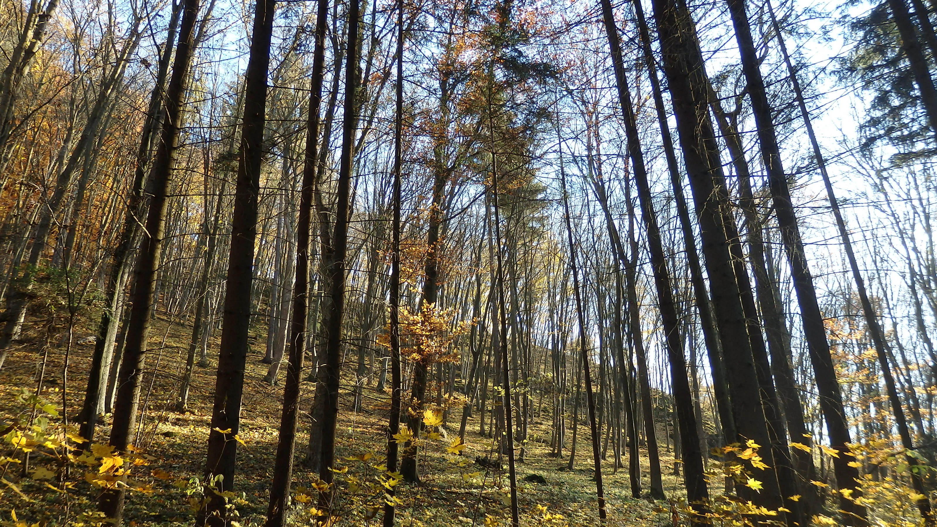
A low angle view looking up through a dense mixed forest in autumn, with tall, slender tree trunks and yellow leaves scattered on the forest floor.
Autumn foliage in the mixed woodland of Přírodní park Říčky.

Přírodní park Říčky history and protected-area timeline

The area now known as Přírodní park Říčky was first given formal protection in 1984, when it was declared a klidová oblast, or quiet zone, a category used to limit disturbance around valued landscapes. In 1992 the area was re-designated as a přírodní park, bringing it under the standard legal framework used in the Czech Republic for larger-scale, landscape-oriented nature protection outside of national parks.

Although the park is primarily valued for its natural assets, its territory also intersects with part of the Lesnický Slavín, a memorial landscape associated with Czech forestry tradition. This gives the park a dual historical character: a relatively recent layer of nature conservation sitting alongside an older landscape tied to the history of forest management in Moravia. The forested character of much of the area itself reflects that history, with earlier plantings of spruce monocultures still visible on many slopes that would once have supported a more diverse broadleaf forest.

Přírodní park Říčky landscape and geographic character

The terrain of Přírodní park Říčky is shaped by the Drahanská vrchovina, a highland area east of Brno that rises here from about 370 meters along the Říčky brook to more than 500 meters in the highest parts. The underlying geology is built from alternating sedimentary layers of conglomerate and shale of marine origin, locally overlain by Devonian limestones that become more prominent toward the western edge of the park, where the landscape transitions toward the eastern margins of the Moravian Karst and small karst phenomena begin to appear.

Streams have carved the most distinctive features of the local scenery. The narrow valleys of the Říčky, Malá Říčky, and Hostěnický potok cut into the highlands, accompanied by a dense network of tributary brooks, springs, and small pools that give the area its lush, water-rich character. Several named springs, including Habrová, Koretinka, Wiehlova, Pod Hádkem, and V Srdci, are noted for their potable water quality. The valley floors widen in places into small alluvial flats, while the slopes between valleys carry mixed forest, planted spruce stands, and open thermophilic woodland on the warmer exposures.

Přírodní park Říčky ecosystems, habitats, and plant life

Ecologically, the park captures a transition between upland central European forest and warmer Moravian woodland types. Beech enclaves survive on cooler slopes and in higher positions, holding a place for classic central European broadleaf forest within an otherwise heavily modified wooded landscape. On the warmer south-facing slopes and in upper valley positions, fragments of thermophilic oak woodland with sessile oak persist, accompanied by a herb layer of warmth-loving plants.

The most distinctive habitat, and the one most closely tied to the park's identity, is the system of near-natural alluvial meadows along the meandering Říčky brook. These wet meadows support a rich community of protected and rare plants typical of central European floodplain meadow systems, with species such as European globeflower, may-flowering marsh orchid, yellow flag iris, marsh valerian, and common twayblade, while pools and oxbows in the same corridor host the carnivorous southern bladderwort. Across most of the rest of the park, the natural vegetation has been altered by past forestry, with extensive spruce monocultures covering slopes that would once have supported more diverse broadleaf forest.

The park's hydrology is a defining ecological feature in its own right. A dense network of small streams, springs, and seepage areas, combined with a small number of fishponds and ponds, maintains the moisture regime that supports both the meadows and the cooler beech enclaves, and creates the conditions for a rich community of amphibians and insects.

Přírodní park Říčky wildlife and species highlights

The fauna of Přírodní park Říčky reflects the area's mix of forest, meadow, and stream habitats. Amphibians and reptiles are particularly well represented, with common toad, European tree frog, alpine newt, fire salamander, common European adder, and several species of grass snakes recorded in the wetter parts of the park.

Birds are the most conspicuous group, especially those tied to the forested interior. Typical woodland species breed here, including black stork among the larger wetland and forest birds, and a range of woodland raptors such as northern goshawk and Eurasian sparrowhawk. The woodpecker community includes black woodpecker and middle spotted woodpecker, while woodland specialists such as Eurasian woodcock occur in the more sheltered forest stretches. Along the streams, grey wagtail is a characteristic sight, occupying the rocky and gravelly reaches of the brooks and small rivers.

Přírodní park Říčky conservation status and protection priorities

Přírodní park Říčky protects a relatively compact but ecologically diverse highland landscape at the eastern edge of the Moravian Karst. Its main conservation value lies in the survival of the alluvial meadow complex along the Říčky brook, which remains one of the more intact examples of species-rich wet meadow habitat in the region, and in the persistence of fragments of thermophilic oak forest that would otherwise have been lost to spruce planting pressure.

The stepwise conservation history of the area, beginning with the 1984 quiet zone designation and followed by the 1992 natural park status, reflects an effort to manage human activity at landscape scale rather than at the level of small reserves. By protecting a continuous mosaic of meadows, woodland, springs, streams, and the karst-influenced western fringe, the park safeguards ecological connectivity between these habitats and maintains the hydrological conditions on which both the meadows and the beech enclaves depend.

Přírodní park Říčky cultural meaning and human context

Beyond its natural value, Přírodní park Říčky carries a layer of forestry-related cultural heritage through its overlap with part of the Lesnický Slavín, a memorial landscape in the Czech forest tradition. This association, along with the marked hiking and cycling trails that connect the surrounding villages such as Ochoz u Brna, Hostěnice, Račice-Pístovice, Olšany, and Rousínov, ties the park into a wider regional pattern of countryside use, walking routes, and small-scale Moravian highland settlement.

Top sights and standout views in Přírodní park Říčky

The defining strength of Přírodní park Říčky is the way it concentrates multiple habitat types into a small area. Visitors move between wet alluvial meadows with protected orchids and carnivorous plants, upland beech enclaves, sun-baked thermophilic oak slopes, and the karst-influenced western edge of the area, all underlaid by the same network of small streams and springs.

Equally distinctive is the park's mix of natural and historical landscape value. The Lesnický Slavín connection and a network of color-marked hiking and cycling trails running between the Brno-venkov and Vyškov districts make the area a place where ecological diversity, traditional Moravian forestry heritage, and accessible rural walking routes come together in a single protected package.

Best time to visit Přírodní park Říčky

Přírodní park Říčky is best experienced during the warmer months of late spring and early summer, when the alluvial meadows along the Říčky brook are at their peak. This is when European globeflower, marsh orchids, and yellow flag iris are in flower in the wet meadows, and when woodland bird activity, including woodpeckers and woodland raptors, is most visible in the forested parts of the park. Spring is also favorable for amphibians around the streams and pools, while early autumn brings cooler air through the beech and oak woodlands and more stable walking conditions on the network of marked trails. Winter visits are possible but bring snow, frozen ground, and reduced visibility of much of the park's flora and smaller wildlife.

Monthly climate preview

Long-term representative temperature and precipitation averages for structured analysis

Přírodní park Říčky Climate Normals and Monthly Weather Records

Historical climatology records for Přírodní park Říčky outline measured average temperatures and daily precipitation rates across a twelve-month cycle at a representative elevation. Examining the complete monthly climate dataset provides deeper numerical context for comparative geographic research and regional environmental study.
Annual mean8 °C
-4 °C19 °C
Jan-4°
Feb-2°
Mar
Apr
May13°
Jun17°
Jul19°
Aug19°
Sep14°
Oct
Nov
Dec-2°
Warmest month
July

19.3 °C

Coolest month
January

-3.7 °C

Wettest month
July

2.7 mm/day

Driest month
February

1.2 mm/day

Park location guide

Geography guide, regional context, and park location map for Přírodní park Říčky

Přírodní park Říčky park geography, regions, and map view in Czechia

Understand where Přírodní park Říčky sits in Czechia through a broader geographic reading of the surrounding landscape, nearby location context, and its mapped position within the national park landscape.

How Přírodní park Říčky fits into Czechia

Czech Republic is a landlocked Central European country with a population of approximately 10.9 million people. The nation was established as an independent state on January 1, 1993, following the dissolution of Czechoslovakia. Its capital and largest city is Prague, with other major urban centers including Brno, Ostrava, Plzeň, and Liberec.

Wider geography shaping Přírodní park Říčky in Czechia

The Czech Republic is a landlocked country in Central Europe. It is bordered by Germany to the west, Austria to the south, Poland to the northeast, and Slovakia to the southeast. The landscape is predominantly hilly, with the territory covering 78,871 square kilometers.

Map view of Přírodní park Říčky

Use this park location map to pinpoint Přírodní park Říčky in Czechia, understand its exact geographic position, and read its mapped placement within the surrounding landscape more clearly.

Pigeon | © OpenStreetMap contributors

Visual reference of forested ridges, stream valleys, and wet meadows across the protected landscape

Přírodní park Říčky Photos and Landscape Scenery Visual Explorer

Photographic records capture the varied terrain, beech woodland enclaves, and alluvial habitats characterizing the Drahanská vrchovina highlands. Visual documentation reveals the distinct topography and ecological transitions defining the protected area environment.

A low angle view looking up through a dense mixed forest in autumn, with tall, slender tree trunks and yellow leaves scattered on the forest floor.

A low angle view looking up at a dense mixed deciduous forest on a hillside under a clear blue sky, with many trees lacking leaves indicating late autumn or winter.

Park atlas

Compare nearby highland terrain, stream valleys, and regional conservation areas

Exploring Other Parks Near Přírodní park Říčky and Surrounding Protected Landscapes

Continue exploring protected areas near Přírodní park Říčky by browsing adjacent highland reserves and connected stream valley habitats. Expanding the geographic comparison reveals broader ecological patterns across the surrounding South Moravian regional terrain.
Watercolor illustration of a karst landscape featuring hills, a lake, and cave-like rock formations with green vegetation
Protected landscapeSouth Moravian Region
About 5.3 km away#1 closest

West

Moravian Karst Protected Landscape: Detailed Geographic and Cave System Atlas

Mapped protected boundaries and karst phenomena in the South Moravian Region.

Moravian Karst, designated a Protected Landscape Area, offers a profound look into complex karst geology within the South Moravian Region. This entry within MoriAtlas facilitates a structured discovery of its approximately 92 square kilometers, featuring an intricate network of over 1,100 caves and gorges. Users can explore the mapped extent of this geological treasure, understand its relationship with the surrounding regional geography, and appreciate the unique formations sculpted by underground water systems, including the iconic Macocha Abyss.

Area
92 km²
IUCN
V
Scope
Terrestrial
Water
Minor water
Natural monumentJihomoravský kraj
About 8.5 km away#2 closest

Southwest

Velatická slepencová stráň: A Protected Natural Monument in South Moravia, Czech Republic

Mapping the rare steppe vegetation and conglomerate geology of Jihomoravský kraj.

Velatická slepencová stráň serves as a critical refuge for thermophilous steppe communities within the Jihomoravský kraj region. The site features distinctive conglomerate outcrops and a rich assembly of dry-grassland plants. This mapping resource provides a comprehensive geographic overview of the protected landscape and its specific ecological configuration.

Area
0.017 km²
Established
1951
IUCN
IV
Relief
Upland
A pale, minimalist watercolor painting showing a soft horizon line with hints of green, yellow, and pink foliage against a white background.
Natural monumentJihomoravský kraj
About 10 km away#3 closest

Northwest

Rudice, Seč Natural Monument: A Comprehensive Geological and Landscape Atlas Overview

Protected mineral landscapes and pioneer ecosystems in the Moravian Karst

Rudice, Seč provides a concentrated view into the geological history of the Drahanská vrchovina. The site is a former quarry that now protects unique sedimentary layers, abundant geodes, and secondary pond habitats. This protected monument offers a clear case study of how karstic depressions are filled by Cretaceous materials and how human-modified terrain can recover to host specialized biodiversity.

Area
0.07 km²
Established
2022
IUCN
III
Relief
Upland
Nature reserveJihomoravský kraj
About 10 km away#4 closest

Southwest

Velká Klajdovka Nature Reserve: Steppe and Forest-Steppe Landscape in Jihomoravský Kraj

Ecologically rich protected limestone slopes and terrain near Brno

Velká Klajdovka is a protected natural monument distinguished by its high-value thermophilic vegetation and complex soil structures. Located on the flank of the Hády massif, the reserve offers a unique study of forest-steppe mosaics, rare entomological diversity, and dry oak woodlands that thrive on the boundary of varied geological substrates.

Area
0.09 km²
Established
1988
IUCN
IV
Relief
Upland
Nature reserveJihomoravský kraj
About 13 km away#5 closest

Southeast

Volkramy Nature Reserve: Geography and Protected Habitat Mapping in South Moravia

Sub-Pannonian steppe grassland and sandy landscape terrain.

Volkramy serves as a critical nature monument in the Czech Republic, protecting a dense concentration of rare steppe flora and dry-grassland ecosystems on sandy substrates. This protected area within the Jihomoravský kraj region showcases a unique combination of open grassland, orchard heritage, and post-industrial sand quarry habitats that provide nesting sites for specialized bird colonies.

Area
0.072 km²
Established
2023
IUCN
IV
Relief
Upland
Natural monumentJihomoravský kraj
About 14 km away#6 closest

West

Soběšické rybníčky Natural Monument: A Detailed Geographic Atlas of the Jihomoravský kraj Forest Ponds

Mapping the protected wetland terrain and amphibian breeding landscapes of central Moravia.

Explore the geographic and conservation profile of Soběšické rybníčky, a protected forest monument in the Czech Republic. The site represents a vital wetland network that maintains stable amphibian populations within a dense, shaded valley setting of the Soběšice Highlands, offering a focused look at small-scale protected landscape management.

Area
0.012 km²
Established
1987
IUCN
IV
Relief
Upland
A soft watercolor painting showing a rolling landscape with hills, scattered trees, and rocky outcrops, rendered in pastel greens and pinks.
Natural monumentBrno
About 17 km away#7 closest

West

Medlánecká skalka Natural Monument: Mapped Protected Landscapes and Geography in Brno

A rare urban-adjacent steppe and rocky habitat site

Medlánecká skalka is a protected natural monument located in the Medlánky district of Brno, Czech Republic. Spanning a small but significant rocky slope, this site preserves thermophilous dry-grassland communities and essential habitats for rare flora like the Pulsatilla grandis. Its unique topography and skeletal soil composition make it an important geographic reference point for understanding steppe-like ecosystems in the South Moravian region.

Area
0.003 km²
Established
1999
IUCN
IV
Relief
Upland
A horizontal watercolor painting showing rolling green hills with small patches of trees under a soft, pale sky.
Natural monumentJihomoravský kraj
About 17 km away#8 closest

West

Medlánecké kopce Natural Monument: Exploring Protected Steppe Habitats in Northern Brno

A rare mosaic of dry grasslands and rocky outcrops in Jihomoravský kraj

Medlánecké kopce preserves a critical landscape of thermophilic flora and insect communities on the edge of the Brno basin. The site is noted for its xerothermic vegetation, including the large-flowered pasqueflower, which thrives on its unique metabasite and loess soil composition. This protected area offers a look at how specialized steppe ecosystems persist within a heavily developed regional environment.

Area
0.118 km²
Established
1988
IUCN
IV
Relief
Upland

Common questions about visiting, size, designation, and location context for Přírodní park Říčky

Přírodní park Říčky FAQs for park facts, access, geography, and protected area context

Find quick answers about Přírodní park Říčky, including protected-area facts, park geography, trail and visitor context, and how the park fits into its surrounding country and regional landscape.
MoriAtlas Explorer

Continue Your Protected Areas Search Across the Global Atlas

Deepen your exploration by continuing the structured search for national parks and protected areas worldwide. Utilize the comprehensive filtering capabilities to compare different conservation landscapes and refine your understanding of global park geography. Discover more about the distribution and characteristics of protected natural areas.

Global natural geography