Mori Atlas logo
State or regional parkPyramid Creek Falls Provincial Park

Examining the glacial geography, hanging valley terrain, and waterfall boundaries within this unique provincial park

Pyramid Creek Falls Provincial Park: A Protected Landscape in the British Columbia Interior

Pyramid Creek Falls Provincial Park protects a dramatic 300-foot, two-tier cascade situated along the eastern bank of the North Thompson River. This protected area originates from a glacially scoured hanging valley, where cold, glacier-fed waters descend through steep forest terrain. The distinctive pyramid-shaped fan of the lower waterfall serves as a primary geographic landmark for rail travelers passing through the interior of British Columbia.

waterfallglacier-fed creekhanging valleyNorth Thompson RiverBritish Columbia interiorprovincial park

Pyramid Creek Falls Provincial Park

State or regional park

Park overview

Structured park overview, official facts, and landscape profile for Pyramid Creek Falls Provincial Park

Pyramid Creek Falls Provincial Park park facts, protected area profile, and essential visitor context

Review the core facts for Pyramid Creek Falls Provincial Park, including designation, size, terrain, visitor scale, habitats, and operating context in one park-focused overview.

About Pyramid Creek Falls Provincial Park

Pyramid Creek Falls Provincial Park is a compact provincial park in the central interior of British Columbia, established to protect one striking natural feature: the waterfall where Pyramid Creek drops from a hanging valley into the North Thompson River. The park sits on the east side of the North Thompson valley, in a region shaped by glacial processes, with the broader landscape dominated by river-cut valleys, forested mountain slopes, and creeks descending from higher ground above the river corridor.

What makes the park interesting beyond its small footprint is the interplay between geology and hydrology. Pyramid Creek is glacier-fed, meaning that its flow and character are tied to meltwater from snowfields and ice higher in the surrounding mountains. Over time, the creek has carved a hanging valley that ends abruptly at the river valley wall, producing the two-tiered cascade that defines the park today. The larger lower drop spreads outward near the base into a fan shape reminiscent of a pyramid, which gives both the creek and the park their name.

The park's setting within the North Thompson River corridor places it in a region known for its mix of boreal and montane forest, cold river waters, and dramatic seasonal runoff. While the park itself is small, its location between Blue River and Valemount situates it near some of the most rugged and least densely populated terrain in southern British Columbia, an area where the Rocky Mountain Trench and the Cariboo Mountains shape both climate and scenery. For travellers driving Highway 5 along the east side of the valley, the falls are visible across the river across the river, while for rail passengers travelling between Vancouver and points north and east, the falls become one of the most photographed natural moments along the route.

Quick facts and research context for Pyramid Creek Falls Provincial Park

Province: British Columbia, Canada. Location: east bank of the North Thompson River, between Blue River and Valemount. Protected status: provincial park. Defining feature: a two-drop waterfall on Pyramid Creek descending from a hanging valley. Total drop: approximately 300 feet. Named for the pyramid-shaped fan of the larger lower drop. Most accessible viewpoint: Via Rail's The Canadian train route, which runs alongside the falls.

Park context

Deeper park guide and search-rich context for Pyramid Creek Falls Provincial Park

Pyramid Creek Falls Provincial Park history, landscape, wildlife, and travel context

Explore Pyramid Creek Falls Provincial Park through its history, landscape character, ecosystems, wildlife, conservation priorities, cultural context, and seasonal travel timing in a structured park guide built for atlas discovery and search intent.

Why Pyramid Creek Falls Provincial Park stands out

Pyramid Creek Falls Provincial Park is best known for the dramatic two-stage waterfall that gives the park its name. The falls drop roughly 300 feet from a hanging valley carved by glacier-fed Pyramid Creek, with the lower drop fanning outward into a distinctive pyramid shape near the bottom. This glacial cascade, set against the forested east bank of the North Thompson River valley, is the park's defining natural landmark and the reason most travellers hear about the place at all. Equally distinctive is the park's relationship with the Canadian National Railway and Via Rail's The Canadian. Because the falls sit on the far side of the North Thompson from Highway 5, they are notoriously hard to reach by road. The railway line, which hugs the river's east bank, runs almost directly past the base of the falls, making the train one of the most reliable ways to experience them up close, and turning the park into a recognized scenic landmark along the Canadian rail corridor.
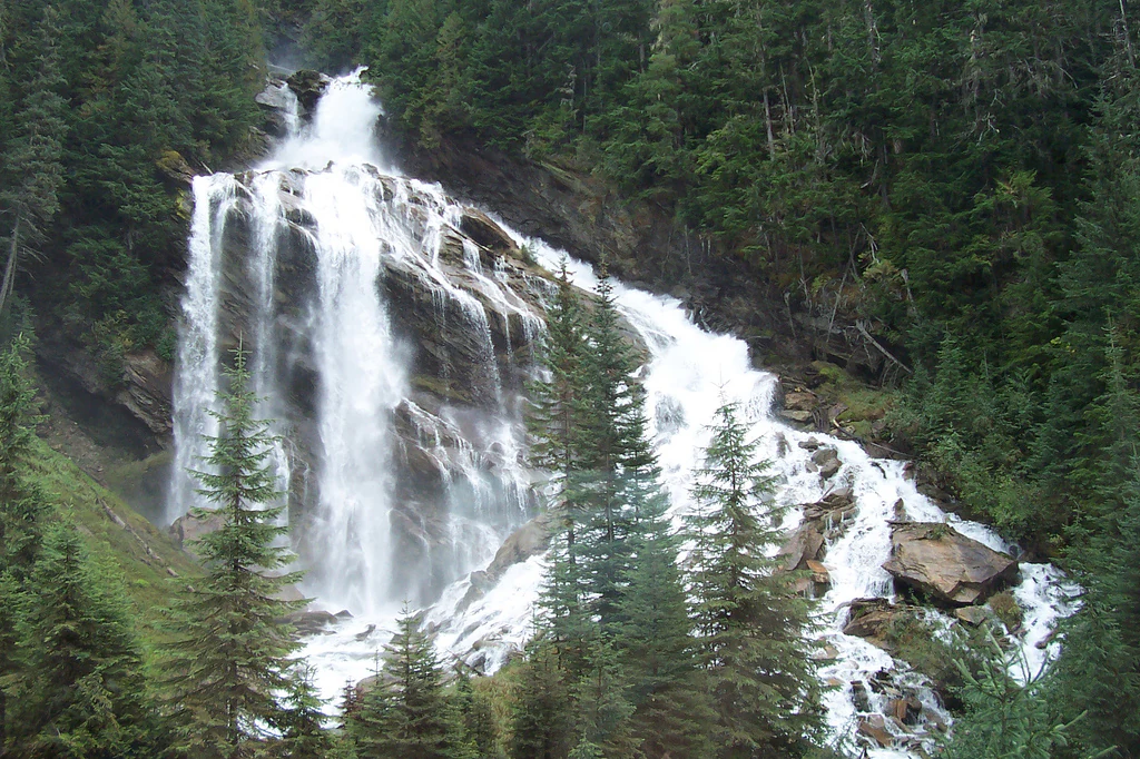
A wide, tiered waterfall flows down a rocky cliff face surrounded by dense evergreen forest.
Pyramid Creek Falls cascades down a tiered rock face into the dense forest of British Columbia.

Pyramid Creek Falls Provincial Park history and protected-area timeline

Limited historical detail is available about the establishment and administrative history of Pyramid Creek Falls Provincial Park beyond its recognition as a British Columbia provincial park. Its identity is closely intertwined with the arrival of the railway through the North Thompson valley, since the route of the Canadian National Railway, and later Via Rail's The Canadian, passes almost directly past the base of the falls. The park's modern reputation is tied in large part to this rail access, with the falls being announced by train crew as The Canadian approaches from either direction and the train slowing to give passengers a clearer view.

Pyramid Creek Falls Provincial Park landscape and geographic character

The landscape of Pyramid Creek Falls Provincial Park is defined by the sharp contrast between the deep valley of the North Thompson River and the elevated hanging valley through which Pyramid Creek flows. The North Thompson has carved a broad, forested glacial valley, while Pyramid Creek descends from a higher, glacially scoured basin above. Where the two landscapes meet, the creek plunges roughly 300 feet in two stages, with the lower drop fanning into a broad pyramid-shaped fan near the river side of the valley.

The terrain around the falls is strongly influenced by glacial history. The hanging valley itself is a classic product of alpine glaciation, where a smaller tributary glacier was unable to deepen its trough as much as the much larger North Thompson glacier below. When the glaciers retreated, Pyramid Creek was left high on the valley wall, suspended above the main river valley and forced to fall the remaining distance. The result is a vertically dramatic, narrow descent of cold, glacier-influenced water through a steep, forested slope.

At the base of the falls, Pyramid Creek continues briefly before passing beneath the railway tracks and joining the North Thompson River. The river itself flows through a wide, gravel-influenced valley flanked by forested slopes rising toward the higher peaks of the surrounding region. Although the park occupies only a small footprint on the east bank, the surrounding visual landscape is dominated by the vertical relief of the falls and the layered ridges and forested slopes of the North Thompson corridor.

Pyramid Creek Falls Provincial Park ecosystems, habitats, and plant life

The ecological character of Pyramid Creek Falls Provincial Park is shaped by its position along the cold, glacier-influenced North Thompson River system. The creek that feeds the falls is glacier-fed, which means its waters carry cold temperatures and high seasonal variability in flow, with the strongest volumes typically tied to snowmelt and ice melt higher in the surrounding mountains. This hydrology influences the kinds of plant communities and microhabitats that can establish along the creek's short but steep course.

Vegetation in and around the park reflects the interior wet belt and montane forest conditions typical of the central British Columbia interior. The slopes around the falls tend to be cloaked in coniferous forest, with moisture-loving species taking advantage of the spray zone near the base of the cascade. The river valley floor adds a different ecological layer, with riparian vegetation following the North Thompson shoreline and a cooler, more sheltered microclimate beneath the valley walls.

Although the park is small, its concentration of vertical relief, waterfalls, cool spray zones, and adjacent river habitat creates a compact mosaic of microenvironments within a short distance. This kind of compressed ecological gradient, where alpine glacier, hanging valley, dense conifer forest, and major river corridor meet, is one of the defining ecological traits of the North Thompson region that the park represents.

Pyramid Creek Falls Provincial Park wildlife and species highlights

Detailed species records for Pyramid Creek Falls Provincial Park are not well documented in available sources. The broader North Thompson River valley, however, is recognized habitat for wildlife typical of British Columbia's central interior, including species associated with coniferous forest, rivers, and mountainous terrain. General patterns in similar nearby habitats include the presence of ungulates such as moose and elk, predators such as black bears and wolves, and a range of smaller mammals, raptors, and songbirds tied to the forest and river edge.

The cold, glacier-fed waters of Pyramid Creek and the North Thompson also support fish populations typical of large interior river systems, while the spray zone and damp microclimates near the falls tend to attract moisture-loving invertebrates, amphibians, and birds that favour wet forest conditions. Without more specific local records, the park's wildlife value is best understood as a small but ecologically coherent piece of the larger North Thompson wildlife corridor.

Pyramid Creek Falls Provincial Park conservation status and protection priorities

As a British Columbia provincial park, Pyramid Creek Falls Provincial Park benefits from formal protected-area status that limits extraction, development, and other activities that would alter the natural values the park is intended to preserve. Its conservation significance is tied primarily to the preservation of the waterfall and its surrounding glacial landscape, including the hanging valley landform, the cold, glacier-fed creek system, and the forested slopes that connect the upper basin to the North Thompson River valley.

The park also has wider conservation value as one of several anchor natural landmarks along the North Thompson River corridor. By protecting the immediate setting of the falls, including the shoreline ecology and forest cover adjacent to the North Thompson, the park contributes to maintaining habitat continuity along a river system that links the interior plateau to higher mountain terrain. Its small size limits its role as a stand-alone wildlife refuge, but its preservation of an iconic geological and hydrological feature is its main conservation contribution.

Pyramid Creek Falls Provincial Park cultural meaning and human context

The cultural context of Pyramid Creek Falls Provincial Park is closely tied to the history of rail travel through the North Thompson valley. The Canadian National Railway, and later Via Rail's flagship service The Canadian, made the falls part of the visual rhythm of one of Canada's most famous long-distance train journeys. Crew members announce the approach to the falls from both directions and the train slows, an experience that has cemented the falls as a shared cultural landmark recognized by rail travellers, photographers, and railway enthusiasts across the country.

For highway travellers in the region, the falls also function as a focal point of the North Thompson scenery between the communities of Blue River and Valemount, and they represent one of the visual highlights of travel along Highway 5 through this stretch of central British Columbia.

Top sights and standout views in Pyramid Creek Falls Provincial Park

Pyramid Creek Falls Provincial Park protects one of the most photogenic waterfalls in British Columbia's North Thompson valley, a 300-foot, two-tier cascade emerging from a hanging valley carved by a glacier-fed creek. The lower drop's spreading pyramid-shaped fan creates a distinctive visual landmark that has become associated with rail travel through the region.

Equally notable is the park's role as a scenic highlight of The Canadian train route. Because road access is limited, the railway provides one of the best vantage points on the falls, and the slow approach past the cascade has made the park a recognizable feature of cross-Canada rail tourism.

Best time to visit Pyramid Creek Falls Provincial Park

Seasonal character at Pyramid Creek Falls Provincial Park is closely tied to the glacier- and snowmelt-driven flow of Pyramid Creek. The most powerful and visually dramatic conditions are typically associated with the spring and early summer melt season, when cold, glacier-fed water surges through the hanging valley and over the two drops. Late summer and early autumn often bring lower flows but a more stable viewing experience, while winter transforms the surrounding landscape into a snow-covered, frozen setting where the falls may be reduced to ice formations along the cliff face. For rail travellers, the experience is year round and largely independent of road-season considerations.
Monthly climate preview

Long-term representative point measurements tracking monthly temperature and precipitation variation

Pyramid Creek Falls Provincial Park Climate Normals and Temperature Rhythms

Historical data records multi-year temperature fluctuations and daily precipitation rates across twelve measured monthly intervals at a representative elevation point. Examining the complete climate profile provides detailed month-by-month values for comparative environmental analysis.
Annual mean-2 °C
-13 °C11 °C
Jan-13°
Feb-12°
Mar-8°
Apr-3°
May
Jun
Jul11°
Aug11°
Sep
Oct-1°
Nov-9°
Dec-13°
Warmest month
July

11.5 °C

Coolest month
December

-13.4 °C

Wettest month
June

3.5 mm/day

Driest month
February

2 mm/day

Park location guide

Geography guide, regional context, and park location map for Pyramid Creek Falls Provincial Park

Pyramid Creek Falls Provincial Park park geography, regions, and map view in Canada

Understand where Pyramid Creek Falls Provincial Park sits in Canada through a broader geographic reading of the surrounding landscape, nearby location context, and its mapped position within the national park landscape.

How Pyramid Creek Falls Provincial Park fits into Canada

Canada is a federal parliamentary constitutional monarchy spanning North America from the Atlantic to the Pacific and Arctic Oceans. With a population of over 41 million, it is officially bilingual in English and French at the federal level. The country gained independence from the United Kingdom through a gradual process culminating in 1982.

Wider geography shaping Pyramid Creek Falls Provincial Park in Canada

Canada occupies the northern portion of North America, sharing its longest international border with the United States. The country extends from the Atlantic Ocean to the Pacific Ocean and northward into the Arctic Ocean, giving it the longest coastline of any nation.

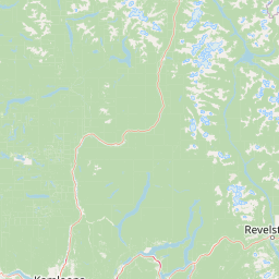
Map view of Pyramid Creek Falls Provincial Park

Use this park location map to pinpoint Pyramid Creek Falls Provincial Park in Canada, understand its exact geographic position, and read its mapped placement within the surrounding landscape more clearly.

Pigeon | © OpenStreetMap contributors

Location context for Pyramid Creek Falls Provincial Park

British Columbia

Visualizing the rugged interior terrain, hanging valleys, and iconic glacial waterfall

Pyramid Creek Falls Provincial Park Photos, Scenery, and Protected Landscape Views

Visual records capture the striking geography of Pyramid Creek Falls Provincial Park, featuring the dramatic two-stage waterfall plunging from a glacial hanging valley. Detailed imagery reveals the steep coniferous forests and river corridor environments that define the protected landscape.

A wide, tiered waterfall flows down a rocky cliff face surrounded by dense evergreen forest.

Park atlas

Compare adjacent protected areas and regional valley conservation landscapes

Explore Other Parks Near Pyramid Creek Falls Provincial Park and Surrounding Landscapes

Browse nearby provincial parks and protected terrain located across the rugged North Thompson River corridor. Compare surrounding glacial valleys and forest reserves to understand the wider geographic context.
National parkAlberta
About 62 km away#1 closest

Northeast

Jasper National Park National Park: Mapped Protected Landscape and Alberta Geography

Explore Alberta's regional park context and natural terrain.

Jasper National Park is a key protected national park in Alberta, Canada, offering extensive natural landscapes. This park page details its precise geographic location, outlines its protected boundaries, and provides context within the regional geography of Western Canada. Discover the mapped terrain and the park's significance as a protected area within a broader atlas perspective.

Area
10,878 km²
Established
1907
IUCN
II
Visitors
2.4M annual
National parkCanada
About 128 km away#2 closest

East

Banff National Park: Exploring Canada's Iconic National Park Protected Landscape and Geography

Mapped park boundaries and regional geographic context for Banff National Park.

Gain a structured understanding of Banff National Park as a key protected area within Canada. This resource details its identity as a national park, providing insights into its geographic setting and mapped landscape. It serves as a vital point for atlas-based discovery, helping to contextualize Banff National Park's significance within Canada's protected lands and natural terrain.

Area
6,641 km²
Established
1885
IUCN
II
Visitors
4.1M annual
National parkColumbia-Shuswap Regional District
About 132 km away#3 closest

Southeast

Glacier National Park: A National Park within Canada's Protected Landscape Atlas

Explore its mapped boundaries and regional geography.

Glacier National Park represents a significant protected area entity within the broader Canadian geography. This page offers an atlas-oriented perspective on its identity as a national park, focusing on its mapped geographic spread and role as a conservation landscape. Users can explore the park's place within the Columbia-Shuswap Regional District and understand its distinct contribution to the national protected area framework.

Area
1,349 km²
Established
1886
IUCN
II
Visitors
4M annual
National parkBritish Columbia
About 152 km away#4 closest

Southeast

Mount Revelstoke National Park: Explore Protected Landscape Geography and Mapped Boundaries

British Columbia's National Park Atlas Entry

Delve into the protected landscape of Mount Revelstoke National Park, a critical national park located in British Columbia. This entry provides a detailed look at its mapped geographic extent and protected area identity, offering valuable context for regional atlas exploration. Understand the park's distinct contribution to the mapped natural landscapes of Canada.

Area
260 km²
Established
1914
IUCN
II
Visitors
775.2K annual
State or regional parkBritish Columbia
About 180 km away#5 closest

Southwest

Porcupine Meadows Provincial Park: Protected Interior Landscapes and Plateau Geography

High-elevation sub-alpine meadows on the Bonaparte Plateau

Porcupine Meadows Provincial Park serves as a critical protected area within the interior of British Columbia. The terrain is characterized by expansive sub-alpine meadows, boggy wetland complexes, and mature old growth forest stands. This remote high-elevation environment offers a unique look at the plateau geography situated west of the North Thompson River, highlighting the transition between alpine habitats and forest interior.

Area
27.04 km²
Established
1996
IUCN
II
Relief
Upland
A watercolor painting showing a serene lake view with forested shoreline, grassy foreground, and rolling mountains in the distance, set against a soft, light background.
State or regional parkBritish Columbia
About 182 km away#6 closest

South

Mara Provincial Park: Protected Shoreline and Geographic Features in British Columbia

Mapping the Shuswap region's essential day-use lakeshore environment

Situated on the southern edge of Mara Lake, Mara Provincial Park functions as a key protected site in the Shuswap region of British Columbia. This area provides public access to sandy beaches and serves as the primary boat launch for the surrounding interior lake system, preserving natural terrain against private lakeshore development.

Area
0.05 km²
Established
1958
IUCN
II
Relief
Lowland
National parkBritish Columbia
About 189 km away#7 closest

Southeast

Yoho National Park: Mapped Protected Area in British Columbia's Geography

Exploring the park's protected boundaries and terrain.

Yoho National Park is presented here as a distinct national park within British Columbia's vast geographic framework. This page provides a structured view of its protected land status, allowing for detailed exploration of its mapped boundaries and surrounding natural landscapes. Understand Yoho National Park's place in the Canadian atlas through its specific geographic features and protected area context.

Area
1,313 km²
Established
1886
IUCN
II
Visitors
663.9K annual
A horizontal watercolor illustration depicting gentle green hills, a small grove of trees, and a pale ground plane against a white background.
Protected areaBritish Columbia
About 198 km away#8 closest

Southwest

Lac du Bois Grasslands Protected Area: Mapped Geography and Interior Plateau Landscapes

Exploring dryland ecosystems and native prairies in British Columbia.

Located in the Thompson-Nicola Regional District, this protected area spans over fifteen thousand hectares of rolling hills and elevated rocky benches. It remains a flagship example of interior plateau conservation, preserving a unique ecological gradient that stretches from arid sagebrush-covered terrain up into denser montane coniferous forest communities.

Area
157.12 km²
Established
1996
IUCN
II
Relief
Upland

Common questions about visiting, size, designation, and location context for Pyramid Creek Falls Provincial Park

Pyramid Creek Falls Provincial Park FAQs for park facts, access, geography, and protected area context

Find quick answers about Pyramid Creek Falls Provincial Park, including protected-area facts, park geography, trail and visitor context, and how the park fits into its surrounding country and regional landscape.
MoriAtlas Explorer

Continue Your Protected Areas Search Across the Global Atlas

Deepen your exploration by continuing the structured search for national parks and protected areas worldwide. Utilize the comprehensive filtering capabilities to compare different conservation landscapes and refine your understanding of global park geography. Discover more about the distribution and characteristics of protected natural areas.

Global natural geography