
Mori Atlas logo
Nature reserveRabengrund von Wiesbaden

Examining the ecological landscape patterns and mapped habitat boundaries of this urban-fringe nature reserve

Rabengrund von Wiesbaden: A Protected Nature Reserve in the Taunus Foothills of Hesse

(Naturschutzgebiet Rabengrund von Wiesbaden)

The Rabengrund von Wiesbaden represents a vital protected landscape situated on the lower slopes of the Taunus range, just north of the state capital of Hesse. This nature reserve and designated European Flora-Fauna-Habitat site preserves a complex mosaic of wet flushes, dry grasslands, and mature beech forests that evolved from historic agricultural land use. The area functions as a significant ecological corridor, connecting the forested Taunus ridges to the northern urban edges of Wiesbaden.

meadowsorchidsnature reserveFFH areaNatura 2000Taunus foothills
A flat vector-style illustration of a peaceful mountain valley scene, featuring a central waterfall descending into a river, surrounded by trees, grassy meadows, and distant cliffs under a pale sun.

Rabengrund von Wiesbaden

Nature reserve

Park overview

Structured park overview, official facts, and landscape profile for Rabengrund von Wiesbaden

Rabengrund von Wiesbaden park facts, protected area profile, and essential visitor context

Review the core facts for Rabengrund von Wiesbaden, including designation, size, terrain, visitor scale, habitats, and operating context in one park-focused overview.

About Rabengrund von Wiesbaden

The Rabengrund von Wiesbaden occupies a sheltered valley on the northern rim of Wiesbaden, where the eastern Taunus foothills descend toward the city. Although it sits within walking distance of Wiesbaden's central districts, the reserve preserves a landscape that feels markedly different from the surrounding built-up area. Open meadows, damp brook valleys, and patches of forest form an interconnected mosaic that has been shaped by human activity for nearly two millennia.

The character of the reserve is defined by its long history of extensive land use. The meadows and low-lying grasslands owe their current composition to grazing and hay-cutting traditions that descend from the Roman settlement of Aquae Mattiacorum, the Roman-era predecessor of Wiesbaden. That continuity of low-intensity management has allowed a distinctive mix of dry, acid, and moisture-loving plant communities to persist in close proximity, something that would otherwise have been lost to either intensification or abandonment.

Geologically, the Rabengrund lies within Taunus quartzite terrain that is also important for Wiesbaden's drinking water supply. The Münzbergstollen, a nineteenth-century water tunnel driven into the ridge west of the reserve, still taps groundwater from these rocks. The springs on the valley floor, including the Habelsquelle that feeds the Schwarzbach stream, were used for drinking water already in Roman times, and a Roman villa rustica has been identified in the vicinity.

Ecologically, the reserve functions as a refuge for plant communities typical of older cultural landscapes. Bodacid semi-dry grasslands alternate with lean, warmth-loving oat-grass meadows, moor-grass flushes in the wetter depressions, and beech forest on the slopes. Reed communities line the small watercourses. The combination of wet and dry, open and shaded, supports an exceptional variety of orchids and invertebrates, including the dark meadow-knopf ant-blue butterfly.

Because the area lies so close to the city, it is heavily used for recreation; cyclists, riders, walkers, and model aircraft enthusiasts all use the trail network. Protection status, including its designation as a nature reserve in 1988 and embedding within the Natura 2000 network in 2000, is intended to ensure that the existing rare-species habitat is preserved against both ecological stress from overuse and the broader loss of such habitats across the region. A geological circular trail has been laid out around the reserve, and the area is managed by the Chausseehaus forestry office of Hessen-Forst.

Quick facts and research context for Rabengrund von Wiesbaden

Rabengrund von Wiesbaden is a nature reserve in the Nordost district of Wiesbaden, administratively within the Sonnenberg cadastral area, on the lower slopes of the Taunus mountains. It was designated on 22 March 1988 and covers roughly 79 hectares, with a linked 83.76-hectare FFH site added in May 2000 as part of the Natura 2000 network.

The reserve lies between 210 and 300 meters in elevation, with a mean annual temperature of about 10 degrees Celsius and annual precipitation of 600 to 650 millimeters. It is set within the Naturpark Rhein-Taunus and within Zone I of the city of Wiesbaden landscape protection area, and falls partly inside a water protection zone linked to the historic Münzbergstollen tunnel.

Protection and recognition

Documented terrestrial protection scope, designation context, and verified records

Rabengrund von Wiesbaden Protection Status and International Recognition Data

Rabengrund von Wiesbaden maintains a documented terrestrial protection scope within official conservation databases. Verified records outline the designated status and administrative framework without international recognition sources.

Protection details

Protection scope
Terrestrial
Transboundary protection
No
WDPA ID
165071
Park context

Deeper park guide and search-rich context for Rabengrund von Wiesbaden

Rabengrund von Wiesbaden history, landscape, wildlife, and travel context

Explore Rabengrund von Wiesbaden through its history, landscape character, ecosystems, wildlife, conservation priorities, cultural context, and seasonal travel timing in a structured park guide built for atlas discovery and search intent.

Why Rabengrund von Wiesbaden stands out

Rabengrund is best known for its small, exceptionally orchid-rich meadows and wet flushes set in a valley landscape just north of central Wiesbaden. Several rare orchid species reach a notable presence here, including broad-leaved marsh orchid, small early purple orchid, burnt-tip orchid, and two-leaved snowbell-like hyacinth, and the green tongue orchid has its only known Taunus location within these meadows. The reserve is also recognized for its ability to combine rare habitat types at one site; acid semi-dry grasslands, mesophile oat-grass meadows, moor-grass flushes, beech forest, and reedbeds appear side by side in a compact valley system. This concentration of distinct cultural-landscape habitats within the urban fringe of a state capital gives the site a strong botanical and ecological profile despite its modest size.
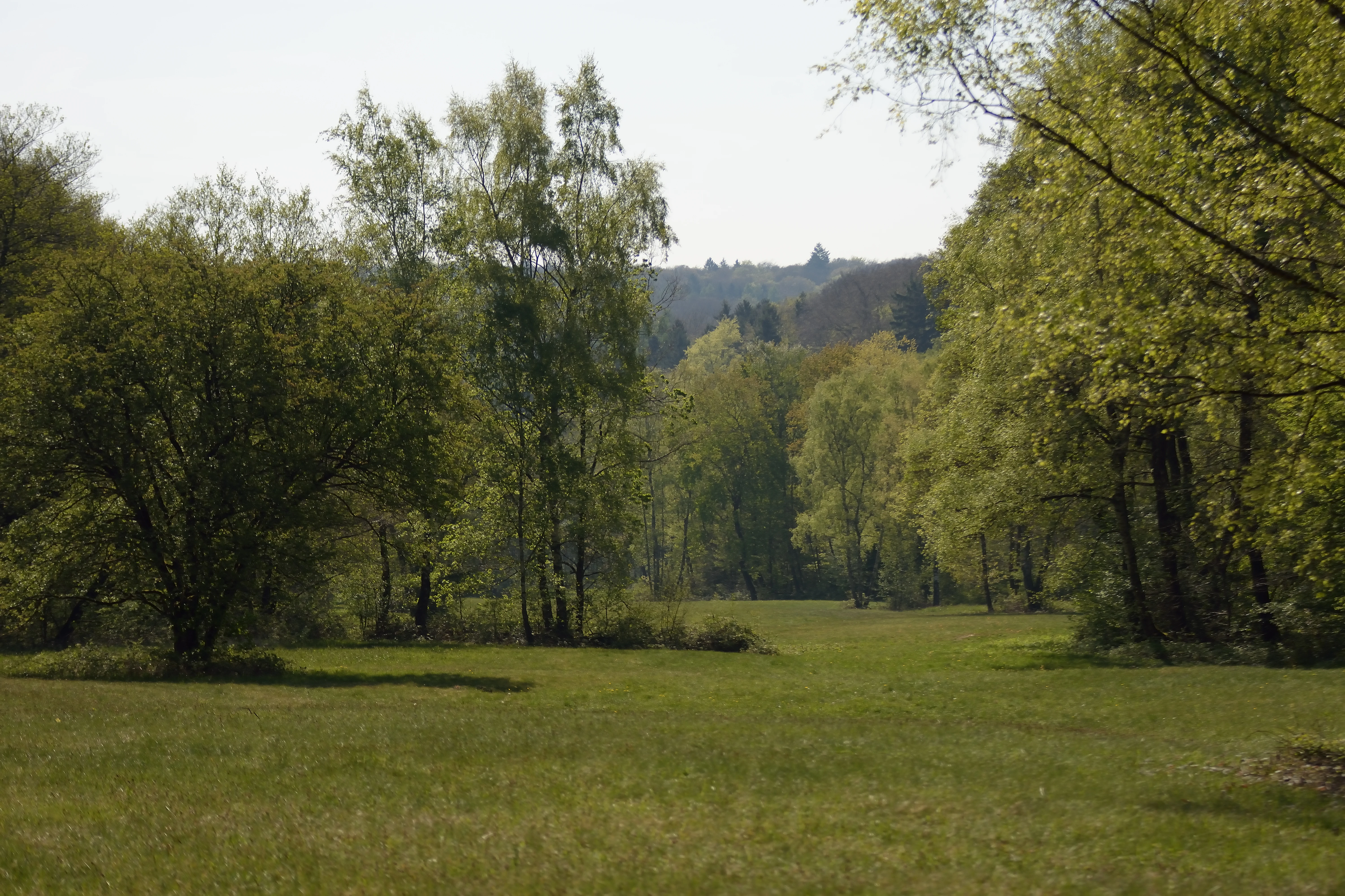
A green meadow surrounded by leafy deciduous trees, with a slightly elevated forested hill in the background.
A view of the meadow landscape and surrounding woodland in the Rabengrund nature reserve.

Rabengrund von Wiesbaden history and protected-area timeline

The meadow and valley landscape of the Rabengrund has been shaped by human activity for a very long time. Its open, semi-natural character originates from extensive grazing and hay-making practices that go back to Roman times, when the nearby settlement of Aquae Mattiacorum was established. A Roman villa rustica, a typical rural estate, has been documented in the vicinity, and the springs at the head of the Rabengrund valley were already tapped for drinking water supply in that era.

The waters of the area continued to play a role in later centuries. The Münzbergstollen, a listed historic water gallery driven into the quartzite ridge west of the reserve, was completed in 1890 and remains part of Wiesbaden's drinking water infrastructure. In the early nineteenth century, the large Kisselborn spring below the Platte ridge was captured in 1821 to 1822 on the initiative of the city planner Christian Zais and connected to Wiesbaden by a dedicated drinking water pipeline.

Modern protection came later. The 79-hectare Rabengrund nature reserve was officially designated on 22 March 1988 under the Hessian Nature Conservation Act in the natural regions of the Rheingau-Wiesbaden Vortaunus and the Wiesbaden Hochtaunus. In May 2000, the area was further recognized at the European level when a larger 83.76-hectare site, formally titled Rabengrund von Wiesbaden mit angrenzenden Flächen, was designated as a Fauna-Fauna-Habitat area within the Natura 2000 network. A biotope complex within the reserve, the grassland-hornbeam-forest-wet-woodland complex north of Wiesbaden, has been protected since 1996.

Rabengrund von Wiesbaden landscape and geographic character

The Rabengrund occupies a small valley system on the lower slopes of the Taunus, north of Wiesbaden's urban core. Elevations within the reserve range from about 210 meters in the lower parts to roughly 300 meters on the surrounding slopes, giving the area a gentle, undulating topography rather than dramatic relief.

To the north rises the Platte ridge, a long Taunus highland crowned by the Jagdschloss Platte hunting lodge at 501 meters, while the abandoned Würzburg hillfort sits further along the same ridge. To the east lie the headwaters of the Goldsteinbach and the connected Goldsteintal FFH area. The Bahnholzer Kopf (288 meters) lies to the southeast, the Neroberg and Wiesbaden's northern cemetery to the south, and the steep Rentmauer rock face rises to the northwest below an unnamed summit at 494 meters.

The valley floor carries the Schwarzbach, a small brook fed by springs within the reserve, which runs southward through the landscape park of the upper Nerotal toward the city center, eventually reaching the Rhine via Biebrich and the Salzbach. Trails, logging roads, and bridle paths radiate along this valley, crossed by a circular geological hiking trail and dotted with small structures such as the Adolf-Weygandt-Hütte hut, the Rettert-Brunnen spring, the Amtmannborn, and the Habelsquelle spring, named after Kaspar Kögler. A small pond sits just below the reserve, draining downstream into the same system.

Rabengrund von Wiesbaden ecosystems, habitats, and plant life

The nature of the Rabengrund is defined by a tight mosaic of habitat types that would normally be separated by larger distances in the wider Taunus. Within its 79 hectares, the reserve combines open meadows with dry, moisture-loving, and forest habitats in close proximity.

The botanical inventory includes acidophilous semi-dry grasslands, lean and warm-loving oat-grass meadows dominated by tall oat grass, and moor-grass flushes in the wetter depressions. Reed communities line the small streams and seepage zones, while stands of beech forest clothe the slopes and edges of the valley. The mixture of shade and open ground, wet and dry substrate, and warmed microclimates near the slopes creates the conditions for several rare plant communities typical of older cultural landscapes in central Europe.

Among vascular plants, orchids are particularly notable. Species recorded within the reserve include broad-leaved marsh orchid, small early purple orchid, burnt-tip orchid, and the two-leaved snowbell-like hyacinth. The green tongue orchid has its only known Taunus location here, marking the site as regionally singular for this species. The autumn lady's tresses was recorded with more than 100 specimens in 1985, but the last flowering and fruiting individuals were seen in 2001, and the species is now considered locally extinct.

At a composite level, the habitat complex since 1996 formally called the grassland-hornbeam-forest-wet-woodland complex north of Wiesbaden groups several individual biotopes, tying together the valley's different habitat types into a single protected ensemble. The climate of the valley, with a mean annual temperature of around 10 degrees Celsius and 600 to 650 millimeters of precipitation, supports both the thermophilic grassland communities and the wet woodland elements at the same site.

Rabengrund von Wiesbaden wildlife and species highlights

The Rabengrund's wildlife significance is closely tied to its combination of meadow, woodland, and stream habitats. While the reserve is small and embedded in an urban fringe, it offers nesting, feeding, and shelter conditions for invertebrates in particular that have become scarce in the wider landscape.

The most distinctive species regularly associated with the reserve is the dark meadow-knopf ant-blue butterfly, a butterfly whose life cycle depends on specific grassland management and on the presence of its host ant species. Its continued presence in the Rabengrund is treated as a conservation marker for the site's overall habitat quality.

The mosaic of wet meadows, reedbeds, streams, and adjacent beech forest is also consistent with breeding habitat for typical central European woodland and meadow birdlife, as well as for small mammals, amphibians in the seepage zones, and a range of insects tied to the orchid-rich grasslands. Although detailed quantitative species lists are limited in the source material, the reserve's role within Natura 2000 underlines the importance attached to its invertebrate and plant communities as well as its vertebrate fauna.

Rabengrund von Wiesbaden conservation status and protection priorities

Conservation in the Rabengrund focuses on maintaining a small, ecologically rich mosaic of habitats that originated from centuries of extensive land use and that would be lost under either intensification or neglect. The reserve is the protected core of a broader landscape that includes Forest-Flora-Habitat (FFH) designation and is embedded in the Naturpark Rhein-Taunus and in Zone I of the city of Wiesbaden landscape protection area.

The stated goal of protection is to secure the rare plant communities of former cultural landscapes and the rare, partly threatened species they support. This includes the orchid-rich grasslands, the moist meadows with moor-grass, the semi-dry acid grasslands, and the associated woodland, all of which depend on continued low-intensity management such as late mowing and grazing. Management is carried out via the Chausseehaus forestry office of Hessen-Forst.

A specific challenge is the high recreational pressure from the nearby city. Cyclists, riders, walkers, and model aircraft enthusiasts all make heavy use of the surrounding network, creating what the source material describes as high ecological stress. The reserve's conservation status, together with educational infrastructure such as the geological circular trail and the formal protection of the inner biotope complex since 1996, is intended to balance these competing demands while preserving the integrity of the underlying habitats. The linkage to the broader beech forest FFH area north of Wiesbaden extends this protective framework into the surrounding woodland.

Rabengrund von Wiesbaden cultural meaning and human context

The Rabengrund lies within a long human-historical landscape, not a wilderness. The Romans used the springs here for drinking water supply at the nearby Aquae Mattiacorum settlement, and a Roman villa rustica has been recorded in the surrounding area, indicating that the valley's low-intensity agricultural use already had a substantial history in antiquity.

In later centuries, the valley was integrated into the infrastructure of the spa city of Wiesbaden. The nineteenth-century Munchbergstollen water gallery on the ridge above the reserve remains a listed monument and a working element of the city's drinking water network, while Christian Zais's early nineteenth-century efforts to capture the Kisselborn spring and pipe its water to Wiesbaden show how closely the surrounding landscape was tied to the city's growth as a health resort.

Local place names such as the Köglerweg, named after Kaspar Kögler, the Habelsquelle spring, and the Adolf-Weygandt-Hütte hut reflect a continuing local identity attached to specific paths, springs, and shelters. Today, the reserve also serves as a near-urban recreation landscape, and the presence of a geological circular trail shows that the cultural reading of the landscape, both its Roman roots and its more recent water-supply role, is treated as part of the site's value.

Top sights and standout views in Rabengrund von Wiesbaden

The standout features of the Rabengrund include its orchid-rich dry and moist grasslands, its single Taunus population of green tongue orchid, and the presence of the dark meadow-knopf ant-blue butterfly as a conservation marker. Equally notable is the compact coexistence of acid semi-dry grassland, oat-grass meadow, moor-grass flush, reedbed, and beech forest within a single small valley.

The reserve's setting also stands out: a substantial nature reserve and Natura 2000 site within walking distance of the state capital of Hesse, framed by the Platte ridge to the north and the Neroberg to the south, with the Münzbergstollen water gallery and Roman-era springs linking the protected valleys directly to Wiesbaden's long history as a spa city. The geological circular trail and management by Hessen-Forst round out the profile of a small but unusually layered protected landscape.

Best time to visit Rabengrund von Wiesbaden

The Rabengrund is most rewarding in late spring and early summer, when the orchid-rich meadows on the valley floor come into bloom. This is when broad-leaved marsh orchid, small early purple orchid, burnt-tip orchid, and two-leaved snowbell-like hyacinth are most visible, against a backdrop of mature meadow grasses in the oat-grass communities. Cool, damp mornings at this time of year are particularly useful for observing both the flora and the butterflies associated with the meadows.

Late summer and early autumn offer a quieter atmosphere, with the surrounding beech forest and the network of springs and brooks becoming more prominent, and reduced recreational pressure compared with the warmer months. Winter visits are also possible along the valley trails, though the floral highlights are absent; the shape of the landscape, the views toward the Platte ridge and the Neroberg, and the calm of the small watercourses are then the main draws. Because the reserve is close to the city, individual closures or path restrictions can occur, and visitors typically adjust to marked routes and the existing trail network rather than straying from it.

Monthly climate preview

Track monthly temperature ranges and precipitation averages across the representative park coordinate

Rabengrund von Wiesbaden Climate Normals and Long Term Temperature Patterns

Historical climate records from nineteen ninety one to twenty twenty map the measured monthly temperature progression and precipitation rhythm across Rabengrund von Wiesbaden. Opening the complete twelve month data profile reveals detailed baseline averages for every individual month at this protected location.
Annual mean9 °C
0 °C20 °C
Jan
Feb
Mar
Apr
May13°
Jun17°
Jul20°
Aug19°
Sep15°
Oct
Nov
Dec
Warmest month
July

19.6 °C

Coolest month
January

-0.1 °C

Wettest month
July

2.2 mm/day

Driest month
April

1.5 mm/day

Park location guide

Geography guide, regional context, and park location map for Rabengrund von Wiesbaden

Rabengrund von Wiesbaden park geography, regions, and map view in Germany

Understand where Rabengrund von Wiesbaden sits in Germany through a broader geographic reading of the surrounding landscape, nearby location context, and its mapped position within the national park landscape.

How Rabengrund von Wiesbaden fits into Germany

Germany is a federal republic in Western and Central Europe with a population of over 83 million across sixteen constituent states. It is Europe's largest economy by nominal GDP and a major global exporter and importer. The capital is Berlin, and the country borders Denmark, Poland, Czech Republic, Austria, Switzerland, France, Luxembourg, Belgium, and the Netherlands.

Wider geography shaping Rabengrund von Wiesbaden in Germany

Germany is located in Western and Central Europe, spanning 357,022 km². It borders Denmark to the north, Poland and the Czech Republic to the east, Austria and Switzerland to the south, and France, Luxembourg, Belgium, and the Netherlands to the west. The country has coastlines on the Baltic Sea and North Sea to the north, with the Alps located in the southern region.

Map view of Rabengrund von Wiesbaden

Use this park location map to pinpoint Rabengrund von Wiesbaden in Germany, understand its exact geographic position, and read its mapped placement within the surrounding landscape more clearly.

Pigeon | © OpenStreetMap contributors

Location context for Rabengrund von Wiesbaden

Hesse
Recorded earthquake history

Explore the Historical Earthquake Catalogue for Rabengrund von Wiesbaden

Access a detailed record of historical seismic events associated with the geography of Rabengrund von Wiesbaden. MoriAtlas provides this filtered catalogue to facilitate the study of regional seismic history through structured data and epicentre mapping.

Rabengrund von Wiesbaden Earthquake History

Catalogued events

31 events

Strongest magnitude

Magnitude 4.3

Most recent event

May 17, 2014

This history includes earthquakes recorded inside the park or within 50 km of its borders

Visualizing the protected valley habitats, meadows, and Taunus foothills

Rabengrund von Wiesbaden Photos and Landscape Scenery

Photographic records illustrate the diverse habitats, spring-fed brooks, and orchid-rich meadows characterizing the protected valley. Visual documentation provides clear insight into the terrain, forest fragments, and ecological structure shaping the protected landscape.

A green meadow surrounded by leafy deciduous trees, with a slightly elevated forested hill in the background.

Park atlas

Compare surrounding Taunus foothill reserves and connected valley landscapes

Other Protected Areas and Parks Near Rabengrund von Wiesbaden

Browse neighboring protected areas and regional reserves located across the surrounding Taunus foothills. Comparing adjacent valley habitats helps trace broader ecological patterns beyond the borders of Rabengrund von Wiesbaden.
A horizontal watercolor painting depicting a soft-focus landscape with rolling green hills, distant light-yellow mountains, and forested slopes.
Protected landscapeHesse
About 4.1 km away#1 closest

West

Naturpark Rhein-Taunus: Mapped Protected Landscapes and Geographic Features in Hesse

Discover the forests, river valleys, and cultural sites of this significant German nature park.

Naturpark Rhein-Taunus encompasses 81,000 hectares of forested ridges and valley systems in the Taunus low mountain range. The area is defined by its near-natural woodland, including the extensive Hinterlandswald, and its unique integration with the Roman Limes and the Rhine wine region, offering a distinct study in protected area geography.

Area
810 km²
Established
1968
Relief
Mountain
Climate
Temperate
A horizontal watercolor illustration of a natural valley scene, featuring an open meadow in the foreground, forest edges in the midground, and rolling hills in the background.
Nature reserveHesse
About 7 km away#2 closest

Southwest

Rechtebachtal bei Georgenborn Nature Reserve: Geographic Profile and Protected Landscape

A mapped stream valley ecosystem in the Hesse Taunus foothills

The Rechtebachtal bei Georgenborn nature reserve protects a two-part valley corridor along the Rechtebach stream near Georgenborn and Martinsthal. This site preserves rare habitat mosaics of meadows and woodland that characterize the transitional zone between the Taunus highlands and the Rhine valley, offering a distinct study in regional conservation geography.

Area
0.185 km²
Established
1989
IUCN
IV
Relief
Upland
A watercolor painting showing a soft, atmospheric landscape with a river flowing through green hills and gentle, misty mountains.
Nature reserveRhineland-Palatinate
7.7 km away#3 closest

South

Inselrhein Nature Reserve, Rhineland-Palatinate: A Geographic and Protected-Area Atlas

River islands, floodplain forests, and Upper Rhine wetlands

Inselrhein features a chain of natural river islands and side channels forming a critical wetland habitat. The terrain transition from soft-wood to hardwood forest communities creates a layered landscape. Examine the protected boundaries and geographic significance of this river corridor between Mainz and Bingen, documented within the Rhineland-Palatinate atlas.

Relief
Lowland
Climate
Temperate
Access
Easy access
Scope
Terrestrial
A wide watercolor illustration showing a winding river flowing through a green floodplain with scattered trees and pale pink and purple hills in the distance.
Nature reserveHesse
About 8.2 km away#4 closest

South

Rettbergsaue Nature Reserve: Geography and Protected Landscapes in the Rhine Valley

A vital river island ecosystem and floodplain forest in Hesse.

Rettbergsaue serves as an essential riverine habitat in the Upper Rhine. This nature reserve, characterized by its alluvial woodland and riparian meadows, offers a detailed study of sediment-formed islands and the interplay between main-channel water flow and sheltered side-arm environments within the state of Hesse.

Area
0.68 km²
Established
1978
Relief
Lowland
Climate
Temperate
Watercolor painting of a misty river landscape with green trees, reeds, and soft hills in the background.
Nature reserveHesse
About 8.9 km away#5 closest

Southwest

Niederwallufer Bucht Nature Reserve: Rhine Floodplain Landscape and Geographic Context

Protected riparian habitat in the state of Hesse

Niederwallufer Bucht represents a key example of a conserved Rhine riverbank environment. This nature reserve protects a delicate mix of soft-wood forests, sheltered backwater bays, and riparian meadows. By maintaining these wetlands against the backdrop of the heavily settled Rheingau, the site provides a vital node of ecological continuity and a clear look at floodplain terrain within central Germany.

Area
0.13 km²
Established
2000
IUCN
IV
Watercolor painting of a gentle green valley with scattered trees and a winding path, featuring soft pastel tones.
Nature reserveHessen
About 10 km away#6 closest

Northwest

Pohlbachtal bei Adolfseck Nature Reserve: Geography and Protected Area Profile

Western Hintertaunus mosaic landscape in Hessen

Pohlbachtal bei Adolfseck protects a near-natural brook valley and surrounding slopes within the Rhein-Taunus Nature Park. This reserve sustains diverse habitats, from wet meadow floodplains to deciduous forest fringes, while preserving historical layers like the Roman Limes along its valley edges in Hessen.

Area
0.226 km²
Established
1990
IUCN
IV
Nature reserveHesse
About 11 km away#7 closest

East

Prügelwiesen bei Wiesbaden in Breckenheim: Protected Fen and Meadow Nature Reserve

Mapped landscapes and wetland conservation in Hesse, Germany

Prügelwiesen bei Wiesbaden in Breckenheim preserves a diverse wetland ecosystem featuring calcareous fens, sedge beds, and traditional orchard meadows. Located in the Rhine-Main region, this nature reserve offers a look into rare grassland communities and groundwater-dependent habitats that characterize the transition between the Taunus foothills and the Main lowlands.

Area
0.079 km²
Established
1994
IUCN
IV
Relief
Lowland
A soft watercolor painting depicting rolling green hills and a forested landscape under a pale, sunrise-hued sky.
Nature reserveHessen
11 km away#8 closest

Northeast

Rossert - Hainkopf - Dachsbau Nature Reserve: Geography and Protected Taunus Forest Landscapes

A preserved ridge system in the Hessen region of Germany

The Rossert - Hainkopf - Dachsbau nature reserve represents a compact but ecologically vital ridge system in the Taunus foothills. Spanning over 120 hectares of mixed forest, this protected area preserves the transition between woodland and open meadow while securing the headwaters of the Wellbach stream within its geographic boundaries.

Area
1.19 km²
Established
1977
IUCN
IV

Common questions about visiting, size, designation, and location context for Rabengrund von Wiesbaden

Rabengrund von Wiesbaden FAQs for park facts, access, geography, and protected area context

Find quick answers about Rabengrund von Wiesbaden, including protected-area facts, park geography, trail and visitor context, and how the park fits into its surrounding country and regional landscape.
MoriAtlas Explorer

Continue Your Protected Areas Search Across the Global Atlas

Deepen your exploration by continuing the structured search for national parks and protected areas worldwide. Utilize the comprehensive filtering capabilities to compare different conservation landscapes and refine your understanding of global park geography. Discover more about the distribution and characteristics of protected natural areas.

Global natural geography