Mori Atlas logo
National parkRajma National Park

Mapping the boundaries and natural terrain of this key protected area in North Africa.

Rajma National Park National Park: Protected Landscape Geography and Atlas Context in Libya

Rajma National Park stands as a significant protected area within Libya, offering a distinct facet of North African geography. This page provides an atlas-driven exploration of Rajma National Park, focusing on its mapped boundaries, natural landscape context, and its role as a designated national park. Understanding its geographic placement is crucial for comprehending the distribution of protected lands across the region.

wetland conservationdesert ecosystemsNorth Africaprotected areadate palm oasesarid land wildlife

Rajma National Park

National park

Park overview

Structured park overview, official facts, and landscape profile for Rajma National Park

Rajma National Park park facts, protected area profile, and essential visitor context

Review the core facts for Rajma National Park, including designation, size, terrain, visitor scale, habitats, and operating context in one park-focused overview.

About Rajma National Park

Rajma National Park serves as a protected area in Libya's Jabal al Gharbi District, covering territory south of Tripoli in the country's northwestern interior. The park's setting within a landlocked district means it lacks the coastal diversity found in some of Libya's other protected areas along the Mediterranean. Instead, Rajma protects a unique wetlands environment surrounded by desert and mountain landscapes characteristic of the Jabal al Gharbi region. The area shares ecological similarities with other Libyan interior parks such as Abughilan National Park, which also features mountainous terrain and harsh desert environments. The park's wetlands, supported by natural water sources, create conditions capable of sustaining more diverse vegetation than the surrounding arid landscape. Date palms form a significant component of the park's vegetation, with fig and olive trees also present in areas with adequate moisture. These palm groves represent important ecological and cultural features, providing habitat for wildlife while also supporting traditional land uses in the region.

Quick facts and research context for Rajma National Park

Rajma National Park is located in the Jabal al Gharbi District of Libya, a landlocked administrative region in the country's interior. The park protects a wetlands area surrounded by desert and mountainous terrain, creating a habitat island within the arid Saharan landscape. Vegetation is dominated by date palms, with fig and olive trees also present. The park supports desert-adapted wildlife including striped hyenas, wildcats, lizards, snakes, and rodent populations. This protected area represents an important ecological asset within Libya's interior, offering conservation value for species adapted to harsh desert conditions.

Protection and recognition

Mapping the documented terrestrial protection scope and regional environmental framework

Rajma National Park Protection Status and Conservation Designation

Browsing the terrestrial designation of Rajma National Park reveals its official conservation status and documented regional boundaries. Accessing verified environmental datasets supports clear geographic navigation and helps researchers compare global protected landscapes.

Protection details

Protection scope
Terrestrial
Transboundary protection
No
Park context

Deeper park guide and search-rich context for Rajma National Park

Rajma National Park history, landscape, wildlife, and travel context

Explore Rajma National Park through its history, landscape character, ecosystems, wildlife, conservation priorities, cultural context, and seasonal travel timing in a structured park guide built for atlas discovery and search intent.

Why Rajma National Park stands out

Rajma National Park is best known for its unusual combination of wetland habitats within a desert environment, a rare occurrence in Libya's arid interior. The park features abundant date palm groves, creating oases that support both wildlife and traditional agricultural use. Its location in the Jabal al Gharbi region places it within an area characterized by mountainous terrain and harsh desert conditions, distinguishing it from Libya's coastal protected areas. The presence of striped hyenas and wildcats adds to the park's ecological significance, as these species represent some of the larger mammals adapted to survival in this challenging environment.

Rajma National Park history and protected-area timeline

The specific establishment history of Rajma National Park is not detailed in the available source material. Protected areas in Libya have been established under various governmental frameworks aimed at preserving the country's natural heritage, including both coastal and interior ecosystems. The designation of Rajma as a national park reflects recognition of the ecological value represented by its wetland habitats within the broader desert context. As one of Libya's protected areas, the park contributes to the country's system of natural preservation, though detailed institutional history regarding its creation and management would require additional sources.

Rajma National Park landscape and geographic character

The landscape of Rajma National Park combines desert terrain with wetland environments, creating a distinctive visual character within Libya's interior. The surrounding Jabal al Gharbi District features mountainous terrain that influences the local environment, while the broader region is characterized by harsh desert conditions typical of the Sahara's northern margins. Within the park, the wetlands areas supported by groundwater create contrasts with the surrounding arid landscape. Date palm groves represent the most visually prominent vegetation, forming green oases against the desert backdrop. The combination of desert, mountains, and wetland creates a landscape of ecological significance, where water availability supports more lush vegetation than the surrounding terrain.

Rajma National Park ecosystems, habitats, and plant life

The nature of Rajma National Park centers on its wetland habitats existing within a desert environment, creating an ecological setting of particular value in Libya's protected area network. The park's wetlands provide crucial habitat functions in an otherwise arid region, supporting vegetation communities dominated by date palms alongside fig and olive trees. This vegetation pattern creates microhabitats within the desert, supporting wildlife populations that depend on the more productive wetland areas. The ecological character of the park represents an interface between desert and wetland systems, making it valuable for biodiversity conservation in northern Africa's semi-arid zones. The presence of permanent water sources enables the park to support species assemblages that would not survive in the surrounding desert terrain.

Rajma National Park wildlife and species highlights

The wildlife of Rajma National Park reflects the harsh desert environment of Libya's interior, with species adapted to arid conditions and limited water availability. Reptiles including lizards and snakes are common within the park, representing the most diverse group of vertebrates in this environment. Small mammals including various rodent species also inhabit the area, providing prey for larger predators. Desert mammals present in the park include striped hyenas and wildcats, representing the larger predators adapted to this ecosystem. These species demonstrate the park's conservation value for predator populations in North Africa's desert regions. The wildlife community represents typical Saharan fauna adapted to survive with minimal water and in extreme temperatures, though the wetland areas provide additional resources that support greater biodiversity than surrounding desert zones.

Rajma National Park conservation status and protection priorities

Rajma National Park contributes to Libya's protected area network by preserving a unique wetland habitat within the country's interior. The park's conservation significance derives from its representation of ecological systems that are limited in distribution across northern Africa, where desert conditions dominate. Wetland areas within arid regions serve as biodiversity hotspots, and Rajma's date palm oases provide habitat for species unable to survive in the surrounding desert. The presence of larger mammals including striped hyenas indicates the park supports ecological processes involving predator-prey relationships in this environment. Conservation of the park helps preserve traditional land uses involving date palm cultivation while maintaining natural values. As one of Libya's designated national parks, Rajma represents commitment to protecting the country's natural heritage beyond its more famous coastal ecosystems.

Rajma National Park cultural meaning and human context

The cultural context of Rajma National Park relates to the traditional relationship between local communities and the oasis environments created by date palm cultivation. Date palms have been cultivated across North Africa for millennia, and the presence of abundant date palms within the park suggests long-term human presence and agricultural use of these wetland areas. The combination of date, fig, and olive trees reflects agricultural traditions common throughout the Mediterranean-influenced regions of North Africa. The park's location in the Jabal al Gharbi District places it within a region where communities have adapted to semi-arid conditions through irrigation and oasis agriculture. This cultural landscape represents the intersection of natural wetland ecology with agricultural practices that have shaped the region's character over generations.

Top sights and standout views in Rajma National Park

Rajma National Park's highlights include its unique wetland habitat within Libya's desert interior, featuring extensive date palm groves that create green oases amid arid terrain. The park provides refuge for desert wildlife including striped hyenas and wildcats, representing larger mammals rarely encountered in this harsh environment. Its location in the Jabal al Gharbi District offers access to mountain landscapes distinct from Libya's coastal regions. The combination of wetlands, desert, and mountain scenery creates a varied natural environment within a single protected area. The park preserves ecological communities that depend on groundwater-fed wetlands in a region where such habitats are uncommon and ecologically valuable.

Best time to visit Rajma National Park

The best time to visit Rajma National Park would generally be during the cooler months of the year, typical for desert regions where summer temperatures can be extreme. The winter months from November through March tend to offer more comfortable conditions for outdoor exploration. However, specific seasonal guidance for visiting this particular park would require additional source information about access, facilities, and local conditions. Visitors to desert wetland areas should consider that conditions can vary significantly between seasons, with the wetter months potentially offering more active wildlife activity around water sources.

Monthly climate preview

Examine long-term representative temperature ranges and monthly precipitation patterns across the landscape.

Rajma National Park Climate Normals: Annual Temperature and Precipitation Rhythm

Representative coordinates record measured monthly averages spanning from cool winter minimums to high summer maximum temperatures alongside low daily precipitation levels. Reviewing the complete twelve-month climatology data provides deeper analytical context for environmental monitoring and regional geography research.
Annual mean19 °C
9 °C29 °C
Jan
Feb10°
Mar14°
Apr18°
May23°
Jun27°
Jul29°
Aug29°
Sep26°
Oct22°
Nov15°
Dec10°
Warmest month
August

29.1 °C

Coolest month
January

9 °C

Wettest month
December

1.3 mm/day

Driest month
July

0 mm/day

Park location guide

Geography guide, regional context, and park location map for Rajma National Park

Rajma National Park park geography, regions, and map view in Libya

Understand where Rajma National Park sits in Libya through a broader geographic reading of the surrounding landscape, nearby location context, and its mapped position within the national park landscape.

How Rajma National Park fits into Libya

Libya is a country in North Africa along the Mediterranean coast. Formerly ruled by Italy, it gained independence in 1951 as the Kingdom of Libya and later became famous for Muammar Gaddafi's rule from 1969 to 2011. The country has experienced significant instability since the 2011 civil war. It is known for its vast desert landscapes, oil resources, and strategic geopolitical position in the Sahara.

Wider geography shaping Rajma National Park in Libya

Libya occupies a large territory in North Africa along the Mediterranean Sea. It borders Egypt, Sudan, Chad, Niger, Algeria, and Tunisia. The terrain is predominantly desert with the Sahara covering much of the country. The coastal region in the north is more fertile.

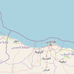
Map view of Rajma National Park

Use this park location map to pinpoint Rajma National Park in Libya, understand its exact geographic position, and read its mapped placement within the surrounding landscape more clearly.

Pigeon | © OpenStreetMap contributors

Location context for Rajma National Park

Jabal al Gharbi District
Park atlas

Uncover surrounding protected areas, comparing their unique desert wetlands and mountain terrains.

Compare Related National Parks and Protected Landscapes Near Rajma National Park

Explore other national parks and protected areas across Libya, focusing on the arid interior and the diverse landscapes found within the Jabal al Gharbi District. Comparing these sites reveals the broader geographic context of wetland conservation, desert ecosystems, and mountain terrains adjacent to Rajma National Park, enriching your atlas-style park discovery.
National parkLibya
About 51 km away#1 closest

Northeast

Abughilan National Park: National Park Protected Landscape and Geographic Context

Explore Libya's protected area and mapped landscape.

Abughilan National Park stands as a designated national park, offering significant value for geographic discovery and understanding protected landscapes. This entry provides context on its mapped boundaries and its role within the regional geography of Libya, Northern Africa. It serves as a detailed point of reference for anyone exploring national parks and protected areas through an atlas-driven lens, focusing on the park's unique environmental context and its position in the landscape.

Area
40 km²
Established
1992
IUCN
II
Scope
Terrestrial
National parkLibya
About 70 km away#2 closest

North

Sirman National Park National Park: Geographic Atlas and Protected Landscape

Explore the mapped terrain and park boundaries.

Sirman National Park is presented here as a distinct national park entity, focusing on its geographic significance and protected landscape characteristics. Users can examine its mapped boundaries, understand its place within the broader regional geography, and explore its natural terrain through an atlas-driven approach. This detailed view supports a structured understanding of the park's conservation status and its unique environmental context, offering factual geographic discovery.

National parkTunisia
About 141 km away#3 closest

Northwest

Sidi Toui National Park: Discover Tunisia's Protected Landscape and Geographic Features

Explore mapped boundaries and regional atlas context.

Sidi Toui National Park, a protected national park within Tunisia, offers critical insights into the country's geographic identity. Examining its mapped boundaries and landscape context within the broader North African region provides a foundational understanding for atlas exploration. This park represents a key point of discovery for understanding protected lands and their placement within regional geography.

Established
1993
Climate
Arid
Scope
Terrestrial
Water
No major water
National parkLibya
About 148 km away#4 closest

Northeast

El Naggaza National Park: A Protected Landscape in Libya's Geographic Atlas

Mapped boundaries and regional terrain of a Libyan national park.

Delve into the specifics of El Naggaza National Park, a designated national park in Libya. This entry focuses on its geographic setting, providing details relevant to atlas exploration and understanding protected land distribution in North Africa. Examine its mapped features and its place within the broader landscape context of the region.

Area
40 km²
Established
1993
IUCN
II
Scope
Terrestrial
National parkKébili Governorate
About 330 km away#5 closest

West

Jebil National Park: Protected Area Details in Kébili Governorate

Explore its mapped boundaries and regional geographic context.

Jebil National Park is a key protected area within the Kébili Governorate, designated as a national park. This focus provides essential geographic context for understanding the region's natural landscapes and conservation efforts. Users can delve into its mapped extent and position within Tunisia's atlas, offering structured discovery of its protected land identity.

Area
1,500 km²
Established
1994
Relief
Lowland
Climate
Arid
National parkGafsa Governorate
About 377 km away#6 closest

Northwest

Bou-Hedma National Park: Mapped Protected Area and Conservation Sanctuary in Gafsa Governorate

Discover Saharan wildlife, Roman ruins, and unique semi-arid landscapes.

Bou-Hedma National Park serves as a crucial conservation hub in Tunisia's Gafsa Governorate, renowned for its success in reintroducing endangered Saharan large mammals like the scimitar oryx and addax. The park's geography spans arid plains and seasonal wadis, encompassing the Ramsar-listed Sebkhet Noual wetland. Its unique landscape also preserves significant Roman-era archaeological sites, offering a rich context for exploring protected-area identity, conservation achievements, and ancient human history within a North African setting.

Established
1980
IUCN
II
Access
Access unknown
Scope
Terrestrial
Nature reserveMalta
About 446 km away#7 closest

North

Filfla Nature Reserve: The Protected Limestone Plateau and Geography of Malta

Tracing the limestone cliffs and seabird sanctuary of the Maltese archipelago

Filfla is a small, uninhabited limestone islet lying 4.5 kilometres south of the main island of Malta. Defined by its 60-metre sea cliffs and flat plateau, this protected nature reserve functions as a crucial Important Bird Area and a landmark for regional Mediterranean biodiversity. Examine the mapped boundaries and geological profile of this site to understand its status as the southernmost extremity of the Maltese archipelago.

Area
0.06 km²
Established
1980
Relief
Upland
Climate
Mediterranean
Wildlife reserveMalta
About 453 km away#8 closest

North

Buskett Gardens Wildlife Reserve: Geography and Protected Landscape Map of Malta

A rare sheltered woodland valley in the central Mediterranean

Buskett Gardens serves as a critical protected woodland in the heart of the Maltese islands. Nestled in the fertile Wied il-Luq valley, the site offers an unusually green, shaded environment of broadleaved trees and conifers. This reserve functions as an Important Bird Area and a historic cultural landscape, providing a lush contrast to the exposed limestone plateau of rural Malta.

Area
0.47 km²
Relief
Upland
Scope
Terrestrial
Water
Minor water

Common questions about visiting, size, designation, and location context for Rajma National Park

Rajma National Park FAQs for park facts, access, geography, and protected area context

Find quick answers about Rajma National Park, including protected-area facts, park geography, trail and visitor context, and how the park fits into its surrounding country and regional landscape.
MoriAtlas Explorer

Continue Your Protected Areas Search Across the Global Atlas

Deepen your exploration by continuing the structured search for national parks and protected areas worldwide. Utilize the comprehensive filtering capabilities to compare different conservation landscapes and refine your understanding of global park geography. Discover more about the distribution and characteristics of protected natural areas.

Global natural geography