Mori Atlas logo
National parkEl Naggaza National Park

Discover the mapped boundaries and regional terrain of this Libyan national park.

El Naggaza National Park: Libya's Protected Landscape Atlas and Geographic Context

El Naggaza National Park stands as a key protected area within Libya's diverse geography, offering a unique window into North Africa's natural landscapes. This page details its specific location, mapped boundaries, and its role as a protected entity within the country's atlas. Understand the park's geographic identity and its contribution to the region's conservation tapestry through structured, map-oriented discovery.

Mediterranean wetlandsCoastal protected areaBirdwatching in LibyaFlamingo habitatNational parkNorth Africa wildlife

El Naggaza National Park

National park

Park overview

Structured park overview, official facts, and landscape profile for El Naggaza National Park

El Naggaza National Park park facts, protected area profile, and essential visitor context
Review the core facts for El Naggaza National Park, including designation, size, terrain, visitor scale, habitats, and operating context in one park-focused overview.

About El Naggaza National Park

El Naggaza National Park represents Libya's commitment to preserving its Mediterranean coastal ecosystems and the biodiversity they support. Situated in the Murqub district near Tripoli, the park was established in 1993 as part of Libya's expanding network of protected areas during that period of environmental policy development. The park's coastal location places it within a biogeographic region that supports species adapted to the Mediterranean climate and the interface between terrestrial and marine environments. As one of Libya's designated national parks, El Naggaza serves both conservation and educational functions, providing a reference site for understanding North African coastal ecology and the species that depend on these increasingly threatened habitats.

Quick facts and research context for El Naggaza National Park

El Naggaza National Park is located in the Murqub district of Libya along the Mediterranean coast near Tripoli. Established in 1993, it encompasses 40 square kilometers of coastal and wetland habitat. The park is categorized as an IUCN Category II national park, denoting its primary conservation purpose. Its position along the Mediterranean flyway makes it a critical waystation for migratory bird populations, while its waters support marine mammal populations including seals.

Park context

Deeper park guide and search-rich context for El Naggaza National Park

El Naggaza National Park history, landscape, wildlife, and travel context
Explore El Naggaza National Park through its history, landscape character, ecosystems, wildlife, conservation priorities, cultural context, and seasonal travel timing in a structured park guide built for atlas discovery and search intent.

Why El Naggaza National Park stands out

El Naggaza National Park is best known as a premier birdwatching destination in Libya, with flamingos and various gull species being the most characteristic avian inhabitants. The park's shallow wetland waters and coastal lagoon environments create ideal conditions for these and other waterbird populations. The presence of seals in the park's marine waters adds to its ecological significance, making it one of the few locations in Libya where visitors can observe marine mammals in their natural protected habitat.

El Naggaza National Park history and protected-area timeline

El Naggaza National Park was established in 1993 as part of Libya's broader initiative to develop a national system of protected areas. The creation of the park reflected growing awareness in Libya during the late 20th century of the need to conserve representative examples of the country's natural ecosystems, particularly those in the heavily populated and developed Mediterranean coastal zone. While the park's history as a formal protected area dates only to 1993, the area's ecological significance as a wetland and bird habitat would have been recognized by local communities and naturalists for much longer.

El Naggaza National Park landscape and geographic character

El Naggaza National Park occupies a coastal position along the Mediterranean Sea in northern Libya. The terrain consists of low-lying coastal plains and shallow wetland areas that transition into the marine environment. The landscape is characterized by lagoon systems and intertidal zones that create the shallow, nutrient-rich waters favored by waterbirds and marine species. The Mediterranean coastline in this region features sandy shorelines and nearshore waters that support the park's ecological communities. Given the park's relatively small area and proximity to Tripoli, the surrounding landscape consists largely of agricultural land and coastal development, making the protected area a critical green corridor within a modified landscape.

El Naggaza National Park ecosystems, habitats, and plant life

The nature of El Naggaza National Park centers on its coastal wetland ecosystem, which forms the ecological foundation for the park's biodiversity. These wetland habitats provide critical feeding, nesting, and resting areas for bird populations, particularly species associated with shallow water and mudflat environments. The Mediterranean climate influences the park's ecological character, with seasonal variations in temperature and precipitation shaping the conditions that different species encounter throughout the year. The transition from wetland to marine environments within the park creates a mosaic of habitats that supports both terrestrial and aquatic species, contributing to the overall ecological diversity of the protected area.

El Naggaza National Park wildlife and species highlights

El Naggaza National Park is notable for its bird populations, with flamingos representing one of the park's most iconic species. These large wading birds frequent the park's shallow waters, where they feed on aquatic invertebrates and algae. Various gull species also inhabit the park, taking advantage of the coastal resources and the opportunities for foraging along the shoreline and in nearshore waters. Beyond avifauna, the park supports populations of seals, which represent one of the few marine mammal species found in Libyan waters. The presence of these pinnipeds indicates the ecological health of the park's marine environment and its significance as a coastal habitat.

El Naggaza National Park conservation status and protection priorities

El Naggaza National Park serves as an important conservation unit within Libya's protected area network. The park's designation as an IUCN Category II protected area reflects its primary purpose of ecosystem conservation and national park management. Protecting this coastal wetland area helps preserve biodiversity values that would otherwise be threatened by coastal development, tourism pressure, and other human activities concentrated along Libya's Mediterranean shoreline. The park's role in supporting migratory bird populations extends its conservation significance beyond national borders, contributing to regional and international bird conservation frameworks that depend on protected staging and wintering sites.

El Naggaza National Park cultural meaning and human context

El Naggaza National Park is situated in a region with historical connections to Mediterranean maritime communities, though the sparse Wikipedia source provides limited detail on specific cultural dimensions. The park's proximity to Tripoli places it within the sphere of Libya's most densely populated and historically significant urban area. The coastal wetlands of this region have likely supported human communities through traditional fishing and resource gathering activities over generations, though precise information about contemporary local communities within or adjacent to the park is not available from the source material.

Top sights and standout views in El Naggaza National Park

The standout features of El Naggaza National Park include its role as a Mediterranean wetland sanctuary, its population of Greater Flamingos, diverse gull species, and the presence of seals in its coastal waters. The park provides one of the most accessible wildlife observation opportunities in Libya, particularly for visitors coming from Tripoli. Its status as a designated national park since 1993 makes it a mature protected area within Libya's conservation system, while its relatively compact area allows for focused exploration of its key habitats.

Best time to visit El Naggaza National Park

The best time to visit El Naggaza National Park would typically be during the cooler months of the year when outdoor activity is more comfortable in the Mediterranean climate. Birdwatching opportunities may vary seasonally, with migratory species present during different times of the year depending on their movement patterns along the Mediterranean flyway. The summer months can bring high temperatures that may limit activity levels, while spring and autumn often provide favorable conditions for observing both resident and migratory bird species.

Park location guide

Geography guide, regional context, and park location map for El Naggaza National Park

El Naggaza National Park park geography, regions, and map view in Libya
Understand where El Naggaza National Park sits in Libya through a broader geographic reading of the surrounding landscape, nearby location context, and its mapped position within the national park landscape.

How El Naggaza National Park fits into Libya

Libya is a country in North Africa along the Mediterranean coast. Formerly ruled by Italy, it gained independence in 1951 as the Kingdom of Libya and later became famous for Muammar Gaddafi's rule from 1969 to 2011. The country has experienced significant instability since the 2011 civil war. It is known for its vast desert landscapes, oil resources, and strategic geopolitical position in the Sahara.

Wider geography shaping El Naggaza National Park in Libya

Libya occupies a large territory in North Africa along the Mediterranean Sea. It borders Egypt, Sudan, Chad, Niger, Algeria, and Tunisia. The terrain is predominantly desert with the Sahara covering much of the country. The coastal region in the north is more fertile.

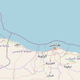
Map view of El Naggaza National Park

Use this park location map to pinpoint El Naggaza National Park in Libya, understand its exact geographic position, and read its mapped placement within the surrounding landscape more clearly.

Pigeon | © OpenStreetMap contributors

Location context for El Naggaza National Park

Murqub
Park atlas

Explore surrounding coastal wetlands and diverse conservation landscapes across North Africa

Discover More Protected Areas Near El Naggaza National Park and Libya's Mediterranean Coast
After exploring El Naggaza National Park, browse additional national parks and protected areas across Libya, tracing the geographic spread of coastal wetlands and crucial bird habitats. Compare these protected landscapes to understand regional conservation efforts and map areas of ecological significance beyond this key site.
National parkLibya

Abughilan National Park: National Park Protected Landscape and Geographic Context

Explore Libya's protected area and mapped landscape.

Abughilan National Park stands as a designated national park, offering significant value for geographic discovery and understanding protected landscapes. This entry provides context on its mapped boundaries and its role within the regional geography of Libya, Northern Africa. It serves as a detailed point of reference for anyone exploring national parks and protected areas through an atlas-driven lens, focusing on the park's unique environmental context and its position in the landscape.

Area
40 km²
Established
1992
IUCN
II
Scope
Terrestrial
National parkTunisia

Sidi Toui National Park: Discover Tunisia's Protected Landscape and Geographic Features

Explore mapped boundaries and regional atlas context.

Sidi Toui National Park, a protected national park within Tunisia, offers critical insights into the country's geographic identity. Examining its mapped boundaries and landscape context within the broader North African region provides a foundational understanding for atlas exploration. This park represents a key point of discovery for understanding protected lands and their placement within regional geography.

Established
1993
Climate
Arid
Scope
Terrestrial
Water
No major water
National park

Ta' Qali National Park: Malta's Largest Urban Protected Landscape and Recreation Hub

Mapped Gardens, Event Venues, and Recreational Zones

Ta' Qali National Park serves as a vital green lung in central Malta, showcasing a landscape transformed from a wartime airfield into a modern urban protected area. This national park is recognized for its extensive recreational zones, meticulously designed formal gardens, and a prominent open-air concert venue that hosts major cultural events. Its relatively flat terrain and planned infrastructure offer a distinct map-based perspective on urban parkland, highlighting its significance as a major public amenity and a key feature of Malta's landscape.

Area
0.35 km²
IUCN
V
Relief
Lowland
Climate
Mediterranean
National parkGafsa Governorate

Bou-Hedma National Park: Mapped Protected Area and Conservation Sanctuary in Gafsa Governorate

Discover Saharan wildlife, Roman ruins, and unique semi-arid landscapes.

Bou-Hedma National Park serves as a crucial conservation hub in Tunisia's Gafsa Governorate, renowned for its success in reintroducing endangered Saharan large mammals like the scimitar oryx and addax. The park's geography spans arid plains and seasonal wadis, encompassing the Ramsar-listed Sebkhet Noual wetland. Its unique landscape also preserves significant Roman-era archaeological sites, offering a rich context for exploring protected-area identity, conservation achievements, and ancient human history within a North African setting.

Established
1980
IUCN
II
Access
Access unknown
Scope
Terrestrial
National parkKébili Governorate

Jebil National Park: Protected Area Details in Kébili Governorate

Explore its mapped boundaries and regional geographic context.

Jebil National Park is a key protected area within the Kébili Governorate, designated as a national park. This focus provides essential geographic context for understanding the region's natural landscapes and conservation efforts. Users can delve into its mapped extent and position within Tunisia's atlas, offering structured discovery of its protected land identity.

Area
1,500 km²
Established
1994
Relief
Lowland
Climate
Arid
Watercolor painting of a landscape with rolling hills, pink wildflowers, and scattered trees
National park

Pantelleria National Park: A Protected Landscape within Italy's Atlas

Mapped boundaries and regional geographic context.

Pantelleria National Park is a designated national park in Italy offering a distinct protected landscape for exploration. This page provides essential geographic context, highlighting the park's mapped boundaries and its significance within the regional atlas. Understand the terrain and protected land features that define this important natural area.

Area
66.4 km²
Established
2016
IUCN
II
Relief
Highland
National parkTunisia

Boukornine National Park: A Protected Mediterranean Mountain Landscape in Tunisia

Explore its mapped terrain and unique protected ecosystem.

Boukornine National Park in Tunisia represents a significant protected landscape, notable for its central granite peak, Jebel Boukornine, which rises sharply above the surrounding coastal plains. This national park, covering approximately 1,939 hectares, preserves a distinctive Mediterranean mountain ecosystem. Its rugged terrain, rocky slopes, and the presence of Aïn Zargua spring support a unique concentration of species, including notable flora and fauna. Understanding Boukornine National Park provides insight into the regional geography and the importance of conserving these mountainous protected areas within Tunisia.

Area
19.39 km²
Established
1987
IUCN
II
Relief
Mountain
National parkKasserine Governorate

Chambi National Park: Tunisia's Highest Mountain Protected Area and Biosphere Reserve

Explore its mountainous terrain and conservation significance.

Chambi National Park is a protected national park in Tunisia's Kasserine Governorate, safeguarding the country's highest mountain, Djebel Chambi. This park is renowned for its mountainous terrain, semi-arid vegetation, and its role as a critical habitat for endangered species like the Cuvier's gazelle and Barbary sheep. As a UNESCO biosphere reserve, it offers significant insights into North African mountain ecosystems and landscape conservation.

Area
67.23 km²
Established
1980
IUCN
II
Relief
Mountain

Common questions about visiting, size, designation, and location context for El Naggaza National Park

El Naggaza National Park FAQs for park facts, access, geography, and protected area context
Find quick answers about El Naggaza National Park, including protected-area facts, park geography, trail and visitor context, and how the park fits into its surrounding country and regional landscape.
MoriAtlas Explorer

Continue Your Protected Areas Search Across the Global Atlas

Deepen your exploration by continuing the structured search for national parks and protected areas worldwide. Utilize the comprehensive filtering capabilities to compare different conservation landscapes and refine your understanding of global park geography. Discover more about the distribution and characteristics of protected natural areas.

Global natural geography