Mori Atlas logo
National parkRakiura National Park

Discover mapped boundaries and diverse terrain of this subantarctic island's protected wilderness.

Rakiura National Park: New Zealand's Remote Protected Landscape & Atlas Exploration

Rakiura National Park represents the protected heart of New Zealand's Stewart Island, a vast expanse of rugged, forested hills and pristine coastlines. As the nation's most geographically isolated national park, it offers an unparalleled opportunity for atlas-driven discovery of one of its least disturbed natural environments. Explore the mapped boundaries and unique subantarctic landscape that define this significant protected area, providing critical context for understanding New Zealand's diverse geography.

New Zealand national parksIslandsLowland forestsKiwi habitatBirdwatchingRemote wilderness

Rakiura National Park

National park

Park overview

Structured park overview, official facts, and landscape profile for Rakiura National Park

Rakiura National Park park facts, protected area profile, and essential visitor context

Review the core facts for Rakiura National Park, including designation, size, terrain, visitor scale, habitats, and operating context in one park-focused overview.

About Rakiura National Park

Rakiura National Park represents a unique addition to New Zealand's protected area network as the nation's newest national park, established in 2002 to preserve the exceptional natural values of Stewart Island / Rakiura. The park covers nearly 1,400 square kilometres, accounting for approximately 85% of the island's total land area, making it one of the most comprehensively protected landscapes in the country. The park's territory is composed of former nature reserves, scenic reserves, and State Forest areas that were consolidated into a unified national park designation. Unlike the mountainous terrain that characterizes most of New Zealand's national parks, Rakiura is predominantly a lowland forest environment with rolling hills, coastal plains, and an extensive indented shoreline. The park excludes the settlement area around Halfmoon Bay (Oban), the island's only town, as well as certain roads and private or Māori-owned land parcels that remain outside the protected boundary. The establishment of Rakiura National Park marked a significant achievement in New Zealand's conservation history, creating a protected area that preserves not only significant ecological habitats but also the cultural heritage embodied in the island's Māori name and mythology.

Quick facts and research context for Rakiura National Park

Rakiura National Park spans roughly 1,400 square kilometres on Stewart Island, making it the 14th and newest of New Zealand's national parks. The park was officially opened on 9 March 2002 by Prime Minister Helen Clark, Minister of Conservation Sandra Lee, and mountaineer Sir Edmund Hillary. Unlike most New Zealand national parks, Rakiura is predominantly lowland forest rather than alpine terrain, covering the majority of a subantarctic island that sits roughly 30 kilometres south of the South Island's southern coast. The park is managed by New Zealand's Department of Conservation and contains three major tramping tracks: the three-day Rakiura Track, the eight-to-ten-day Northwest Circuit, and the challenging nine-day Southern Circuit.

Protection and recognition

Verifying terrestrial protection scope and the official designation timeline of the park

Documented Protection Status and Legal Designation of Rakiura National Park

Map-based exploration of Rakiura National Park relies on verified terrestrial protection status and designation details established in 2002. Systematic records outline the official boundaries and management scope of the national park to support accurate geographic analysis and regional comparisons.

Protection details

Protection scope
Terrestrial
Designated year
2002
Park context

Deeper park guide and search-rich context for Rakiura National Park

Rakiura National Park history, landscape, wildlife, and travel context

Explore Rakiura National Park through its history, landscape character, ecosystems, wildlife, conservation priorities, cultural context, and seasonal travel timing in a structured park guide built for atlas discovery and search intent.

Why Rakiura National Park stands out

Rakiura National Park is best known as New Zealand's premier destination for wild kiwi viewing, offering what many consider the best opportunity anywhere in the country to observe these iconic flightless birds in their natural habitat. The absence of introduced stoats and ferrets on Stewart Island has allowed kiwi populations to thrive, with approximately 15,000 Southern brown kiwi (tokoeika) inhabiting the island. The park is also notable for its extensive network of tramping tracks through pristine lowland forest, its rugged coastline with isolated sandy beaches, and its significance as a breeding ground for endangered yellow-eyed penguins. The park's cultural connection to Māori mythology, symbolized by the entrance chain sculpture representing the island as the anchor of Māui's canoe, adds a distinctive cultural dimension to the natural landscape.

Rakiura National Park history and protected-area timeline

Rakiura National Park was officially established on 9 March 2002, becoming the 14th national park in New Zealand's system and the most recent addition to the country's network of protected areas. The park's opening ceremony was attended by Prime Minister Helen Clark, Minister of Conservation Sandra Lee-Vercoe, and the celebrated mountaineer Sir Edmund Hillary, underscoring the national significance of this protected area designation. The park was created through the consolidation of various former protected area categories, including nature reserves, scenic reserves, and State Forest lands that together encompassed the bulk of Stewart Island. The creation of the national park followed decades of advocacy for stronger protection of the island's unique natural values. A notable feature at the park's entrance is the chain sculpture designed by Southland sculptor Russell Beck, which was unveiled as part of the park's opening ceremony. This sculpture represents Māori mythology concerning the origins of the New Zealand landscape, specifically the belief that the South Island formed the canoe of the demigod Māui and that Rakiura served as the canoe's anchor, earning the island the alternative name Te Punga o Te Waka a Māui. A duplicate of this sculpture was erected in Bluff in 2008, representing the opposite end of the mythological chain connecting the islands.

Rakiura National Park landscape and geographic character

Rakiura National Park protects the diverse terrain of Stewart Island, a subantarctic island characterized by a rugged landscape of forested hills, extensive coastlines, and remote wilderness areas. The island's topography consists of rolling hills and lower mountain ranges, notably the Tin Range in the east, which rise to elevations of around 700 to 900 metres above sea level. The park's landscape is extensively indented with coves, inlets, and harbours, particularly along the eastern coast where Paterson Inlet provides a deep natural harbour. The coastline features numerous sandy beaches, some of which are extremely isolated and accessible only by foot or boat, including the notable Mason Bay on the western coast. The park's interior is dominated by lowland forest communities, with the terrain generally characterized by soft, rounded ridges and valleys rather than the sharp alpine peaks found in New Zealand's northern national parks. The Freshwater Depression, a significant lowland area, lies in the western portion of the island and is crossed by the Northwest Circuit track.

Rakiura National Park ecosystems, habitats, and plant life

The ecological character of Rakiura National Park is defined by extensive lowland podocarp forests dominated by kāmahi, tōtara, and rimu trees, creating a canopy environment that supports diverse understory and ground-layer plant communities. As one of New Zealand's few large lowland forest ecosystems within a national park, Rakiura provides habitat for plant species that have been displaced from much of the mainland by human activity and introduced species. The park's coastal ecosystems include significant breeding habitat for seabirds and shorebirds, while the forest interior supports populations of native birds, insects, and other endemic fauna. The absence of several introduced mammalian predators that have devastated native wildlife elsewhere in New Zealand, particularly stoats and ferrets, has allowed Stewart Island to retain relatively intact ecological communities. The island's position in the subantarctic zone influences its climate and vegetation patterns, creating conditions that differ from both the mainland and more northern islands.

Rakiura National Park wildlife and species highlights

Rakiura National Park supports remarkable birdlife, most notably the Southern brown kiwi (tokoeika), which represents the largest of New Zealand's kiwi species. The park offers what is widely regarded as the best opportunity in New Zealand for observing kiwi in the wild, with an estimated population of 15,000 individuals inhabiting Stewart Island. The absence of stoats and ferrets has allowed this population to thrive, making wild kiwi sightings a realistic expectation for visitors, particularly during evening hours near the track huts. Coastal areas of the park serve as breeding habitat for the endangered yellow-eyed penguin, one of the world's rarest penguin species. The South Island kākā, a large parrot species, is commonly observed near Halfmoon Bay and Ulva Island, while weka, curious flightless birds, can be found on the offshore islands surrounding Stewart Island. Historically, the Tin Range area within the park was significant as a refuge for the kākāpō, the world's only flightless parrot, with individuals discovered there in the 1970s when the species was presumed nearly extinct.

Rakiura National Park conservation status and protection priorities

Rakiura National Park represents a critical conservation asset for New Zealand, protecting the majority of the nation's third-largest island and preserving ecological communities that have remained relatively intact compared to mainland areas. The park's significance is heightened by the absence of several introduced predator species that have caused catastrophic declines in native wildlife throughout the rest of New Zealand, allowing populations of threatened species to persist at levels not achievable in other protected areas. The park provides crucial habitat for endangered species including the yellow-eyed penguin and supports one of the healthiest kiwi populations in the country. The establishment of the national park consolidated protection over areas previously designated as nature reserves, scenic reserves, and state forests, creating a unified management framework for the island's natural values. The proximity of the park to Codfish Island / Whenua Hou, where kākāpō recovery efforts have been concentrated, demonstrates the broader conservation network of which Rakiura forms an essential component.

Rakiura National Park cultural meaning and human context

Rakiura National Park encompasses landscapes of deep cultural significance to Māori, the indigenous people of New Zealand. The island's Māori name Rakiura translates to land of glowing skies, while the alternative name Te Punga o Te Waka a Māui identifies the island as the anchor of the demigod Māui's canoe in traditional mythology. This mythological heritage is physically represented at the park's entrance by Russell Beck's chain sculpture, which symbolizes the connection between Rakiura and the South Island as described in Māori creation narratives. The park excludes certain Māori-owned land parcels from its boundary, reflecting the recognition of indigenous property rights within New Zealand's protected area framework. The island's human history includes traditional Māori settlement and resource use, with the coastal areas and marine environments complementing the terrestrial protected area.

Top sights and standout views in Rakiura National Park

Rakiura National Park offers visitors several outstanding features that distinguish it within New Zealand's protected area network. The Rakiura Track, a three-day 32-kilometre circuit through lowland forest to Port William and Paterson Inlet, provides a highly regarded backcountry experience with excellent kiwi viewing opportunities near the huts. The park's three major tramping routes—the Rakiura Track, the 125-kilometre Northwest Circuit, and the 70-kilometre Southern Circuit—cater to different experience levels and time commitments, from a three-day introduction to challenging multi-week expeditions. The opportunity to see kiwi foraging in the wild at night represents a unique wildlife experience not easily replicated elsewhere in New Zealand. The park's remote island setting, accessible by ferry or flight from the South Island, offers a wilderness atmosphere distinctly different from the more visited national parks of the mainland.

Best time to visit Rakiura National Park

Rakiura National Park can be visited year-round, though the subantarctic location means weather conditions can be changeable and often damp throughout the seasons. Summer months from December to February generally offer the most stable conditions and longer daylight hours for tramping, while the winter months from June to August can bring cold, wet conditions and shorter days that make longer backcountry trips more challenging. The shoulder seasons of autumn and spring present intermediate conditions with the possibility of both fine weather and periods of rain. Because the park's kiwi are nocturnal, evening and nighttime hours provide the best opportunities for kiwi sightings along the tracks, regardless of season. The park's popularity means that advance booking for hut spaces on the Rakiura Track is advisable during the peak summer period.
Monthly climate preview

Long-term temperature and precipitation profiles for Stewart Island landscapes

Rakiura National Park Climate Normals and Monthly Weather Patterns

Decades of climatological data collected at a key lowland point reveal a maritime profile with moderate monthly mean temperatures staying between 8.0 and 13.4 degrees Celsius alongside persistent year-round precipitation. Exploring the complete twelve-month profile clarifies seasonal minimums and maximums, offering a clear basis for comparative ecological and geographical analysis.
Annual mean11 °C
8 °C13 °C
Jan13°
Feb13°
Mar13°
Apr11°
May10°
Jun
Jul
Aug
Sep
Oct10°
Nov11°
Dec12°
Warmest month
February

13.3 °C

Coolest month
July

8 °C

Wettest month
January

3.7 mm/day

Driest month
August

3 mm/day

Park location guide

Geography guide, regional context, and park location map for Rakiura National Park

Rakiura National Park park geography, regions, and map view in New Zealand

Understand where Rakiura National Park sits in New Zealand through a broader geographic reading of the surrounding landscape, nearby location context, and its mapped position within the national park landscape.

How Rakiura National Park fits into New Zealand

New Zealand is an island nation in the southwestern Pacific Ocean comprising two main islands and numerous smaller islands. Located east of Australia across the Tasman Sea, it features varied topography with the Southern Alps running along the South Island and volcanic terrain on the North Island. The country was settled by Maori people between 1280 and 1350, followed by European exploration beginning in 1642, and became a Dominion in 1907 before gaining full independence in 1947.

Wider geography shaping Rakiura National Park in New Zealand

New Zealand lies in the southwestern Pacific Ocean, east of Australia across the Tasman Sea. The country consists of two main islands, the North Island and South Island, plus over 600 smaller islands. The North Island features volcanic plateaus and hills while the South Island is dominated by the Southern Alps mountain range. The country has a long coastline and is surrounded by the Pacific Ocean.

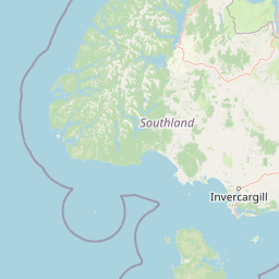
Map view of Rakiura National Park

Use this park location map to pinpoint Rakiura National Park in New Zealand, understand its exact geographic position, and read its mapped placement within the surrounding landscape more clearly.

Pigeon | © OpenStreetMap contributors
Natural feature types

Explore the Mapped Geography and Natural Features of Rakiura National Park

Navigate the structured index of natural features found throughout Rakiura National Park. This MoriAtlas collection offers a detailed perspective on the diverse landforms, forests, and waterways that characterize the rugged wilderness of Stewart Island.
Park atlas

Trace the diverse protected landscapes and regional park geography across New Zealand's unique island environments.

Beyond Rakiura National Park: Discover Other National Parks and Protected Areas in New Zealand

Expand your atlas exploration from Rakiura National Park to browse other national parks and protected areas, focusing on New Zealand's distinct island, coastal, and wilderness landscapes. This broader view allows for detailed geographic comparison, tracing conservation efforts and natural terrain across similar subantarctic and South Island protected regions.
Wildlife reserveNew Zealand
Mapped location lies within the park boundary#1 closest

South

Ulva Island Wildlife Reserve: Mapped Geography and Protected Forest Landscapes

An open sanctuary located in Paterson Inlet, New Zealand

Explore the unique geography of Ulva Island, a 2.7 square kilometre wildlife reserve within Rakiura National Park. This predator free island features dense temperate rainforest, sheltered coastal bays, and vital recovery habitats for native bird species, offering a distinct study in southern New Zealand's protected forest terrain.

Area
2.67 km²
Relief
Lowland
Climate
Temperate
Access
Easy access
Nature reserveSouthland Region
About 5.3 km away#2 closest

West

Codfish Island / Whenua Hou: A Protected Nature Reserve in the Southland Region

Coastal terrain and island geography in New Zealand

Located off the coast of Stewart Island, Codfish Island / Whenua Hou functions as an essential nature reserve. The island features moderate terrain, temperate coastal forests, and a protected landscape that preserves rare species and seabird colonies. Its geography is defined by a remote maritime setting, making it a globally significant site for predator-free wildlife conservation in the Tasman Sea.

Area
14 km²
Established
1987
Relief
Upland
Climate
Temperate
National parkSouthland Region
57 km away#3 closest

North

Fiordland National Park: A Protected Landscape of Glacier-Carved Fiords and Alpine Wilderness

Explore its vast boundaries and unique temperate rainforest.

Fiordland National Park, located in the Southland Region of New Zealand, is a testament to dramatic geological forces, featuring fifteen major fiords like Milford Sound, whose Mitre Peak rises majestically from the water. This protected national park encompasses an immense wilderness of alpine terrain, ancient beech forests, and numerous waterfalls, fueled by exceptional rainfall. Its inclusion in the Te Wāhipounamu World Heritage Area underscores its global significance for biodiversity and natural landscape preservation.

Area
12,607 km²
Established
1952
IUCN
II
Visitors
500K annual
Marine protected areaFiordland
133 km away#4 closest

Northwest

Moana Uta (Wet Jacket Arm) Marine Reserve: Mapped Protected Landscapes in Fiordland

Exploring unique fiord stratification and dense marine coral habitats

Located in the remote southwestern reaches of New Zealand, Moana Uta (Wet Jacket Arm) Marine Reserve preserves a complete fiord system. The area is notable for its exceptional physical conditions, including high black coral density and a distinct freshwater surface layer that sustains diverse underwater communities across steep rock walls, reefs, and deep basins.

Area
20.07 km²
Established
2005
Relief
Lowland
Climate
Temperate
Marine protected areaFiordland
147 km away#5 closest

Northwest

Taipari Roa (Elizabeth Island) Marine Reserve: Fiordland Marine Landscape and Atlas Map

Protected marine terrain and glacial fjord geography

Taipari Roa (Elizabeth Island) Marine Reserve is a protected marine area situated within the complex fjord network of Doubtful Sound. The reserve is characterized by steep underwater rock walls, deep kelp forests, and a unique freshwater cap that allows rare corals and glass sponges to thrive at shallow depths. This geographic overview examines the reserve's protected status and its structural role within the broader Fiordland ecosystem, highlighting the vertical aquatic terrain and surrounding islet environments.

Area
6.13 km²
Established
2005
Relief
Lowland
Climate
Temperate
Marine protected areaFiordland
159 km away#6 closest

Northwest

Kutu Parera (Gaer Arm) Marine Reserve: Fiordland Protected Marine Landscape Atlas

Mapped marine boundaries, stratified fiord ecology, and coastal terrain analysis

Explore the structured geography of Kutu Parera (Gaer Arm) Marine Reserve, a 433-hectare protected area located within the steep, mountain-flanked fjords of New Zealand. Gain insight into its complex underwater features, including vertical rock walls, estuarine basins, and stratified water columns that define this unique marine environment within the Fiordland region.

Area
4.33 km²
Established
2005
Relief
Mixed relief
Climate
Temperate
Marine protected areaFiordland
177 km away#7 closest

North

Kahukura (Gold Arm) Marine Reserve: Marine Protected Area and Fiordland Geographic Atlas

Submerged rocky reefs and vertical rock wall landscapes

Located in the heart of New Zealand, Kahukura (Gold Arm) Marine Reserve provides a vital map of protected coastal terrain. Its unique environment features freshwater caps, tannin-stained deep water, and diverse marine topography ranging from sheltered basin ecosystems to vertical cliff structures. This marine area offers deep insight into the complex geology and conservation dynamics of the Fiordland region.

Area
4.64 km²
Established
2005
Relief
Mixed relief
Climate
Temperate
Marine protected areaFiordland
207 km away#8 closest

North

Hawea (Clio Rocks) Marine Reserve: Protected Marine Geography in Fiordland, New Zealand

Mapping vertical rock walls and stratified fiord water ecosystems.

Hawea (Clio Rocks) Marine Reserve is an ecologically significant marine protected area situated within the deep waters of Hāwea / Bligh Sound. The reserve is defined by its dramatic vertical rock walls, tidal current channels, and the complex water stratification that sustains diverse black coral and reef communities. It offers a unique window into the geological and marine processes that have shaped the rugged coastal landscape of New Zealand's Fiordland.

Area
4.11 km²
Established
2005
IUCN
Ia
Relief
Mountain

Common questions about visiting, size, designation, and location context for Rakiura National Park

Rakiura National Park FAQs for park facts, access, geography, and protected area context

Find quick answers about Rakiura National Park, including protected-area facts, park geography, trail and visitor context, and how the park fits into its surrounding country and regional landscape.
MoriAtlas Explorer

Continue Your Protected Areas Search Across the Global Atlas

Deepen your exploration by continuing the structured search for national parks and protected areas worldwide. Utilize the comprehensive filtering capabilities to compare different conservation landscapes and refine your understanding of global park geography. Discover more about the distribution and characteristics of protected natural areas.

Global natural geography