
Mori Atlas logo
Protected landscapeRattlesnake National Recreation Area

Examining the ecological terrain, drainage patterns, and wildland boundaries of this Northern Rockies conservation unit.

Rattlesnake National Recreation Area: A Mapped Protected Landscape in Western Montana

Rattlesnake National Recreation Area serves as a critical protected gateway between urban Montana and the expansive Rattlesnake Wilderness. This 28,000 acre landscape, organized around the Rattlesnake Creek drainage, features a rich variety of coniferous forests, montane wetlands, and high-country meadows. The area functions as a vital corridor for diverse Northern Rockies wildlife and supports an intricate network of trails that trace the dramatic transition from creek valleys to rugged mountain ridges.

national recreation areaNorthern RockiesLolo National Forestconiferous forestSphagnum bogmontane wetland
A stylized vector illustration showing a grassy field in the foreground, pine forest in the midground, and a soft, pastel-colored sky with clouds in the background.

Rattlesnake National Recreation Area

Protected landscape

Park overview

Structured park overview, official facts, and landscape profile for Rattlesnake National Recreation Area

Rattlesnake National Recreation Area park facts, protected area profile, and essential visitor context

Review the core facts for Rattlesnake National Recreation Area, including designation, size, terrain, visitor scale, habitats, and operating context in one park-focused overview.

About Rattlesnake National Recreation Area

Rattlesnake National Recreation Area occupies a scenic and ecologically important slice of western Montana, stretching north from the outskirts of Missoula into the forested mountains that form the northern edge of the Clark Fork Basin. Its boundaries trace the Rattlesnake Creek drainage, anchoring the recreation area in a landscape of montane valleys, timbered slopes, and high-country basins that transition into the more strictly protected Rattlesnake Wilderness beyond.

The recreation area was created by Congress on October 19, 1980, the same day as the adjoining Rattlesnake Wilderness, signaling a deliberate federal effort to preserve the natural character of this drainage while still allowing for active public outdoor use. Today the unit is administered as part of the Lolo National Forest by the United States Forest Service, and it functions as a hybrid landscape where conservation values and recreation opportunities coexist.

A defining feature of the recreation area is its trail network. More than 73 miles of trails branch through the forest and along the creek, supporting hiking, horseback riding, mountain biking, and cross-country skiing across different seasons. This trail density, combined with easy access from Missoula, makes the area a heavily used local and regional resource for outdoor recreation.

Ecologically, the recreation area is more varied than its modest footprint might suggest. Its forests include patches of Sphagnum riparium and Sphagnum bog habitat at Shoo Fly Meadows, a rare wetland type in the arid Western United States. Its plant communities also support several native orchid species, including Calypso bulbosa, Cypripedium montanum, and Corallorhiza striata, alongside invasive pressures from species such as leafy spurge. These plant communities underpin habitat for a wide range of animals, from native trout in the creek to large mammals and breeding birds in the surrounding forest.

In broader terms, Rattlesnake National Recreation Area represents a distinctive model of federal land management in the Northern Rockies: a recreation-focused unit that protects meaningful ecological values while remaining deeply integrated with the surrounding community.

Quick facts and research context for Rattlesnake National Recreation Area

Rattlesnake National Recreation Area is a 28,000-acre federally administered area in Missoula County, Montana, situated about 4 miles north of the city of Missoula along the Rattlesnake Creek drainage. It is administered by the United States Forest Service as part of the Lolo National Forest and sits directly adjacent to the Rattlesnake Wilderness. Both the recreation area and the adjoining wilderness were established by Congress on October 19, 1980.

The unit functions as a multi-use outdoor landscape with a trail network of more than 73 miles used by hikers, horseback riders, mountain bikers, and cross-country skiers. Ecologically, the area combines montane coniferous forest, rare Sphagnum bog habitat at Shoo Fly Meadows, native orchid populations, and Northern Rockies fauna ranging from bull trout in Rattlesnake Creek to grizzly bears and elk across the surrounding forests.

Protection and recognition

Documented terrestrial protection scope and international recognition records

Rattlesnake National Recreation Area Protection Status and Formal Designation Data

Rattlesnake National Recreation Area maintains a documented terrestrial protection scope within official conservation frameworks. Official records organize administrative status and designation details for thorough reference.

Protection details

Protection scope
Terrestrial
Transboundary protection
No
Park context

Deeper park guide and search-rich context for Rattlesnake National Recreation Area

Rattlesnake National Recreation Area history, landscape, wildlife, and travel context

Explore Rattlesnake National Recreation Area through its history, landscape character, ecosystems, wildlife, conservation priorities, cultural context, and seasonal travel timing in a structured park guide built for atlas discovery and search intent.

Why Rattlesnake National Recreation Area stands out

Rattlesnake National Recreation Area is best known for offering an unusually accessible Northern Rockies wildland experience on the doorstep of Missoula, coupling an extensive multi-use trail system with diverse montane ecology. It is particularly recognized for its Shoo Fly Meadows Sphagnum bogs, one of the few Sphagnum peatland systems in the Western United States, and for the way it frames the transition between a working community landscape and the more remote Rattlesnake Wilderness. The area is also valued for the range of Northern Rockies wildlife that visitors can encounter within a short distance of town, from bull trout and cutthroat trout in Rattlesnake Creek to elk, white-tailed deer, mountain goats, and grizzly bears across the forested ridges. The combination of trail variety, biological richness, and close-to-town access defines much of what the recreation area is known for.
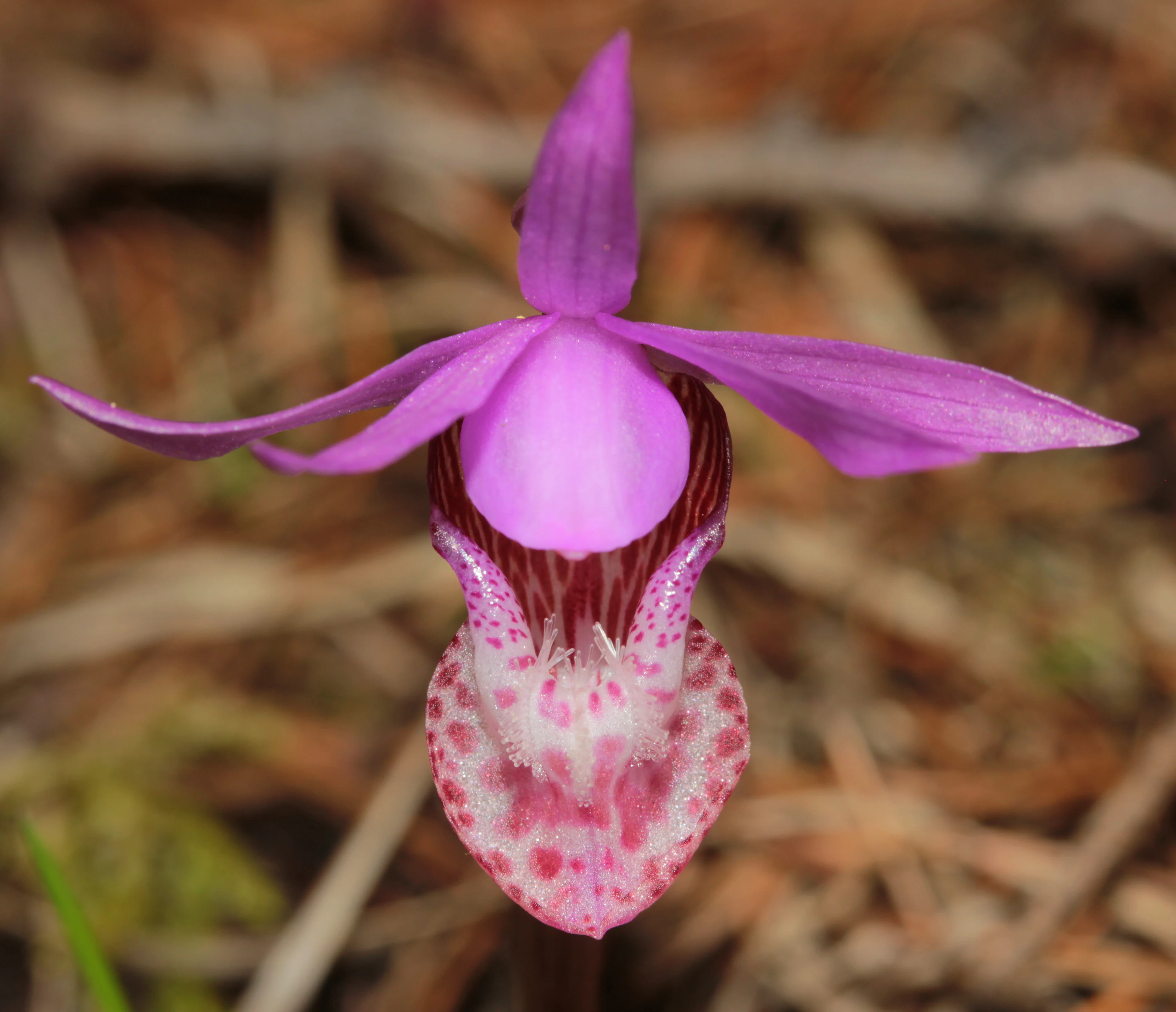
A close up view of a bright purple and pink Calypso orchid flower with a spotted lip, set against a blurred brown forest floor.
A detailed close up of a Calypso orchid in bloom.

Rattlesnake National Recreation Area history and protected-area timeline

No substantial historical content is provided in the source beyond the establishment of the recreation area and the adjacent wilderness by an act of the U.S. Congress on October 19, 1980. The recreation area is administered by the United States Forest Service through the Lolo National Forest, but no further development history, jurisdictional shifts, or milestone events are documented in the available source material.

Rattlesnake National Recreation Area landscape and geographic character

The landscape of Rattlesnake National Recreation Area is shaped by the headwaters and drainage of Rattlesnake Creek as it flows south out of the Northern Rockies mountains toward the Missoula Valley. Forest dominates the terrain, with coniferous slopes rising into ridges and basins that frame the creek corridor. The creek itself runs as a central organizing feature of the topography, cutting a valley that visitors cross and follow on the trail system.

The terrain transitions between lower creek-side slopes nearer Missoula and higher, more rugged country to the north as the recreation area approaches the Wilderness boundary. Meadows and wetland openings interrupt the forest cover, the most notable of which is Shoo Fly Meadows, a montane wetland system hosting Sphagnum bog communities that are uncommon across the Western United States. Combined, these features give the area a layered landscape quality: dense forest in the foreground, creek valleys threading through it, and high country rising toward the wilderness skyline.

Rattlesnake National Recreation Area ecosystems, habitats, and plant life

Ecologically, Rattlesnake National Recreation Area reflects a classic Northern Rockies montane mosaic. Coniferous forest forms the dominant matrix, but the area is unusually enriched by its high-elevation wetland systems: Shoo Fly Meadows harbor Sphagnum riparium and other Sphagnum species in one of the few Sphagnum bogs documented in the Western United States. These wetlands add bog-loving plants, moisture-loving invertebrates, and supporting habitat functions that contrast sharply with the drier coniferous slopes elsewhere in the recreation area.

The forest communities also host a notable assemblage of native orchids, including Calypso bulbosa, Cypripedium montanum, and Corallorhiza striata, indicating the presence of intact mycorrhizal partnerships and relatively mature understory conditions. At the same time, invasive plant species such as leafy spurge have established themselves, creating an ongoing management challenge in preserving native plant communities. The botanical mix of old-forest indicators, native orchids, and montane bog species gives the recreation area a more ecologically nuanced character than many similarly sized Western landscapes.

Rattlesnake National Recreation Area wildlife and species highlights

The wildlife profile of Rattlesnake National Recreation Area reflects the broader Northern Rockies fauna of the Lolo National Forest region, with both aquatic and terrestrial species as defining elements. Rattlesnake Creek supports bull trout, cutthroat trout, and mountain whitefish, making the creek itself a meaningful wildlife and angling resource.

The surrounding forests host a full suite of expected mammal species, including elk, white-tailed deer, mountain goat, and grizzly bear. Black bears and mountain lions are also present, and visitors are formally cautioned about their presence, which reflects the area's working wildland character rather than its purely recreational use. Birdwatchers regularly document more than forty bird species, with notable sightings including pileated woodpecker, great grey owl, ruffed grouse, and the American dipper along the creek corridor. Butterflies such as the green comma and western tiger swallowtail add finer-scale invertebrate diversity to the ecological picture.

Rattlesnake National Recreation Area conservation status and protection priorities

From a conservation standpoint, Rattlesnake National Recreation Area protects a meaningful segment of the Rattlesnake Creek drainage at the western edge of the Northern Rockies. Although classified for recreation rather than as wilderness, the area's protection status, Forest Service administration, and adjacency to the Rattlesnake Wilderness give it a stronger conservation footprint than many similarly accessible landscapes. The Sphagnum bogs at Shoo Fly Meadows are of particular conservation interest, representing one of the few documented Sphagnum peatland systems in the Western United States and providing habitat that is scarce at a regional scale.

The area also helps conserve native orchid populations, supporting Calypso bulbosa, Cypripedium montanum, and Corallorhiza striata within their natural montane setting. Management challenges remain, especially around invasive plants such as leafy spurge, but the recreation area continues to function as important habitat for wide-ranging wildlife species, including grizzly bear, elk, and bull trout, that depend on large interconnected Northern Rockies landscapes.

Top sights and standout views in Rattlesnake National Recreation Area

Rattlesnake National Recreation Area stands out for the rare combination of trail-rich recreation, ecological richness, and proximity to a sizable Montana community. The 73-mile trail network supports hiking, horseback riding, mountain biking, and cross-country skiing across different seasons, making the area unusually versatile for its size.

Equally important are the Sphagnum bog systems at Shoo Fly Meadows, the native orchid populations, and the Northern Rockies wildlife assemblage that includes bull trout, grizzly bear, elk, mountain goat, and over forty documented bird species. The recreation area's adjacency to the Rattlesnake Wilderness and its place within the Lolo National Forest tie it directly into the broader protected landscape fabric of western Montana.

Best time to visit Rattlesnake National Recreation Area

Seasonal character at Rattlesnake National Recreation Area is shaped by the strong contrasts of the Northern Rockies climate. Summer brings the widest range of trail opportunities, with creeks at their most accessible, wildflowers and native orchids in bloom, and the greatest overlap of hiking, horseback riding, and mountain biking conditions. Winter shifts the trail network primarily to cross-country skiing and snowshoeing, when snow cover transforms the forested drainage into a quieter, snow-based recreation landscape.

Shoulder seasons, particularly spring and fall, often bring active wildlife observation, as elk, deer, and grizzly bears move through lower elevations and bird activity remains high around the creek corridor. Because conditions can vary markedly with elevation and weather, visitors should expect Northern Rockies seasonality rather than steady conditions year-round.

Monthly climate preview

Examine long-term representative temperature patterns and monthly precipitation averages

Rattlesnake National Recreation Area Climate Normals and Temperature Rhythms

Historical data records the measured annual temperature and precipitation rhythm across twelve months at a representative coordinate within Rattlesnake National Recreation Area. Reviewing the complete monthly profile provides deeper insight into long-term climate normals and seasonal variations.
Annual mean4 °C
-8 °C17 °C
Jan-8°
Feb-7°
Mar-2°
Apr
May
Jun12°
Jul17°
Aug17°
Sep12°
Oct
Nov-3°
Dec-7°
Warmest month
July

17.4 °C

Coolest month
January

-7.5 °C

Wettest month
June

2.7 mm/day

Driest month
July

1.1 mm/day

Park location guide

Geography guide, regional context, and park location map for Rattlesnake National Recreation Area

Rattlesnake National Recreation Area park geography, regions, and map view in United States of America

Understand where Rattlesnake National Recreation Area sits in United States of America through a broader geographic reading of the surrounding landscape, nearby location context, and its mapped position within the national park landscape.

How Rattlesnake National Recreation Area fits into United States of America

The United States of America is a federal presidential republic and one of the world's largest countries by area and population. It consists of 50 states across a vast territory spanning multiple time zones, with its capital in Washington, D.C. and largest city in New York City. The nation has a diverse economy, influential political system, and significant cultural and military presence globally.

Wider geography shaping Rattlesnake National Recreation Area in United States of America

The United States occupies a vast territory in North America, bordered by Canada to the north and Mexico to the south. The 48 contiguous states stretch from the Atlantic to the Pacific Ocean, while Alaska occupies the northwestern region and Hawaii is an archipelago in the Pacific. The country encompasses diverse terrain including the Rocky Mountains, Appalachian Mountains, Great Plains, and extensive river systems.

Map view of Rattlesnake National Recreation Area

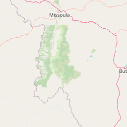
Use this park location map to pinpoint Rattlesnake National Recreation Area in United States of America, understand its exact geographic position, and read its mapped placement within the surrounding landscape more clearly.

Pigeon | © OpenStreetMap contributors

Location context for Rattlesnake National Recreation Area

Missoula CountyMontana

Visualizing the mountain terrain, creek valleys, and Northern Rockies habitats of western Montana

Rattlesnake National Recreation Area Photos and Landscapes

Examine detailed Rattlesnake National Recreation Area images to understand the complex topography, coniferous forest cover, and creek-cut valleys defining the protected landscape. Visualizing the terrain clarifies how montane wetlands and rugged wildland corridors create a distinct ecological transition zone on the edge of the wilderness.

A close up view of a bright purple and pink Calypso orchid flower with a spotted lip, set against a blurred brown forest floor.

A wide view of a lush green meadow in the foreground, transitioning into a dense pine forest on the hillsides under a cloudy sky.

Park atlas

Compare adjacent wildland terrain and regional conservation geography across western Montana.

Explore Parks Near Rattlesnake National Recreation Area and Surrounding Protected Lands

Browse other parks and protected areas near Rattlesnake National Recreation Area to examine connected regional mountain terrain. Expanding the geographic comparison reveals broader patterns across Northern Rockies conservation landscapes.
Protected areaMontana
Mapped location lies within the park boundary#1 closest

Northwest

Lolo National Forest: An Atlas of Protected Lands and Mountainous Terrain in Montana

Ecological transition zone of the northern Rocky Mountains

This protected area covers two million acres of diverse northern Rocky Mountain geography. Known for its massive western red cedars and transitional ecology, the forest features a complex network of ridgelines, glacial lake basins, and river corridors that serve as vital habitat across the Montana landscape.

Area
8,894.85 km²
Established
1906
Relief
Mountain
Climate
Temperate
Wildlife reserveMontana
About 4.8 km away#2 closest

Northeast

Rattlesnake Wilderness: Exploring the Protected Landscapes and Geography of Montana

Rugged alpine terrain and roadless mountain wilderness in the Northern Rockies.

Located in the Lolo National Forest of western Montana, Rattlesnake Wilderness protects an essential network of forested slopes, alpine ridges, and drainage headwaters. This roadless wildlife reserve provides an ecologically intact landscape that serves as a core component of the northern Rockies wilderness system, offering a clear view into the rugged relief of the Rattlesnake Mountains and their significant influence on local watersheds.

Area
133.45 km²
Established
1980
IUCN
Ib
Relief
Mountain
Wildlife reserveMontana
About 36 km away#3 closest

North

Mission Mountains Wilderness: A Rugged Protected Area in the Montana Rocky Mountains

Glacial topography and high elevation alpine ecosystems

Mission Mountains Wilderness is a defining landmark in northwestern Montana, characterized by a steep and narrow mountain spine that rises abruptly above the Flathead Valley. The area protects a full spectrum of ecosystems, from dense coniferous forests to exposed talus slopes and alpine tundra. With its glacially carved cirques and deep U shaped valleys, this wilderness functions as a key component of a larger, jointly managed regional conservation landscape in the United States.

Area
298.97 km²
Established
1975
IUCN
Ib
Relief
Mountain
A watercolor painting depicting a soft, stylized mountain range and a river winding through a valley.
Protected landscapeMontana
About 76 km away#4 closest

East

Helena-Lewis and Clark National Forest: Geographic Overview and Protected Area Map

Montana wilderness spanning the Continental Divide

Spanning from the rolling eastern plains to the crest of the Northern Rockies, Helena-Lewis and Clark National Forest serves as a massive protected landscape in central Montana. This forest system protects eight unique mountain ranges and critical wilderness corridors, offering a comprehensive look at the ecological transition zones of the American Mountain West.

Area
11,000 km²
Established
1897
Relief
Mountain
Climate
Temperate
A soft watercolor painting depicting rolling mountains in the background with a line of forest in the midground and open terrain in the foreground.
Protected landscapeMontana
About 134 km away#5 closest

Northwest

Kootenai National Forest: Geography and Protected Land Map for Northwestern Montana

Northern Rockies mountain ranges and watershed analysis.

Spanning over two million acres, Kootenai National Forest represents a critical protected landscape in the Northern Rockies. This atlas entry details the interplay between the Cabinet Mountains, regional river systems like the Kootenai and Clark Fork, and the dense conifer forests that define this uniquely wet corner of Montana.

Area
8,900 km²
Established
1907
Relief
Mountain
Climate
Temperate
Soft watercolor illustration of a rolling mountain landscape with a forested foreground and faded, distant peaks.
Protected landscapeIdaho
About 138 km away#6 closest

South

Salmon, Challis National Forest: Geography and Protected Land Map in Central Idaho

Extensive alpine ridges and wild river corridors

Spanning over 4.2 million acres, Salmon, Challis National Forest is a foundational protected landscape in Idaho. This area includes the highest peaks in the state, such as Borah Peak, and holds the majority of the Frank Church, River of No Return Wilderness. Utilize this atlas resource to examine the intricate mountain topography, expansive river systems, and the contiguous wild corridors that define this significant portion of the northern Rockies.

Area
17,142.2 km²
Established
1908
Relief
Mountain
Climate
Temperate
A horizontal watercolor illustration depicting a winding river flowing through a forested valley surrounded by soft, hazy mountain silhouettes.
Wildlife reserveIdaho
About 144 km away#7 closest

South

Frank Church, River of No Return Wilderness: Idaho Protected Mountain and River Landscapes

Discover massive roadless geography and river-carved mountain terrain.

Spanning over 2.3 million acres in central Idaho, the Frank Church, River of No Return Wilderness represents one of the most significant intact roadless landscapes in the lower 48 states. This protected area features a complex mosaic of coniferous forests, high-altitude alpine ridges, and the steep, jagged canyons of the Salmon River, creating a unique geographic profile for regional exploration.

Area
9,578.21 km²
Established
1980
IUCN
Ib
Relief
Mountain
National parkMontana
About 145 km away#8 closest

North

Glacier National Park: A Montana National Park with Distinct Protected Landscape Geography

Explore its mapped boundaries and regional natural terrain.

Glacier National Park represents a significant national park entity within Montana, providing a unique lens for understanding protected landscapes and regional geography. As a key component of the US protected areas network, it offers valuable insights into mapped park boundaries and the surrounding natural terrain. This page serves as a gateway to exploring the specific geographic context and landscape identity of Glacier National Park.

Area
4,100.77 km²
Established
1910
IUCN
II
Visitors
2.9M annual

Common questions about visiting, size, designation, and location context for Rattlesnake National Recreation Area

Rattlesnake National Recreation Area FAQs for park facts, access, geography, and protected area context

Find quick answers about Rattlesnake National Recreation Area, including protected-area facts, park geography, trail and visitor context, and how the park fits into its surrounding country and regional landscape.
MoriAtlas Explorer

Continue Your Protected Areas Search Across the Global Atlas

Deepen your exploration by continuing the structured search for national parks and protected areas worldwide. Utilize the comprehensive filtering capabilities to compare different conservation landscapes and refine your understanding of global park geography. Discover more about the distribution and characteristics of protected natural areas.

Global natural geography