
Mori Atlas logo
Wildlife reserveRaven Cliffs Wilderness

A wild expanse of steep rock cliffs, cascading trout streams, and recovered mountain forest.

Raven Cliffs Wilderness: Mapping the Rugged Appalachian Terrain and Protected Landscapes

Raven Cliffs Wilderness covers over 9,000 acres of protected high-country within the northern Georgia mountains. The terrain features dramatic vertical relief, characterized by sheer rock faces, deep shaded hollows, and prominent ridgelines such as Levelland Mountain. Mapped stream corridors like Boggs Creek provide a cold-water backbone, defining a landscape that captures the classic geological character of the southern Blue Ridge.

wilderness areaAppalachian forestwaterfallscliffstrout streamsnational forest
A flat-style digital illustration depicting a mountainous landscape at sunrise with a rocky foreground, sparse trees, and rolling hills in the background.

Raven Cliffs Wilderness

Wildlife reserve

Park overview

Structured park overview, official facts, and landscape profile for Raven Cliffs Wilderness

Raven Cliffs Wilderness park facts, protected area profile, and essential visitor context

Review the core facts for Raven Cliffs Wilderness, including designation, size, terrain, visitor scale, habitats, and operating context in one park-focused overview.

About Raven Cliffs Wilderness

Raven Cliffs Wilderness sits in the southern Appalachian highlands of northeastern Georgia, occupying a rugged section of the Chattahoochee National Forest where narrow hollows, rocky ridges, and mountain creeks come together in a compact but topographically varied protected area. The wilderness is administered by the U.S. Forest Service under the National Wilderness Preservation System, ensuring that the land retains its undeveloped, roadless character and continues to function as a refuge for native Southern Appalachian ecosystems.

The terrain is defined by sharp vertical change and a layered geology typical of the southern Blue Ridge. Lower elevations follow the cool, shaded valleys of Boggs Creek and its tributaries, while the surrounding ridges climb steadily upward toward summits like Levelland Mountain and Cowrock Mountain, which provide sweeping views across the surrounding forest. Between these high points and the valley floor sit the namesake cliffs, towering faces of exposed rock over which the creeks plunge in a series of cataracts.

Ecologically, Raven Cliffs represents a meaningful forest recovery story. Much of the area was logged in the early to mid-1900s, a period when regional timber industries stripped many of Georgia's mountainsides. Since then, the second-growth forest has matured into dense hardwood stands, with scattered pine specimens that have largely passed their sixtieth year, giving the wilderness a richly forested, multi-aged canopy. This regenerated woodland, combined with the rocky cliffs and cold mountain streams, supports a wide range of native plant communities, from moist slope forests at lower elevations to drier, more exposed communities on the upper ridges.

For visitors and recreationists, the wilderness is closely associated with its more accessible scenic attractions, particularly the Raven Cliffs Scenic Area and Raven Cliff Falls, which serve as gateway experiences into the broader backcountry. From these focal points, the trail network extends into quieter, more remote sections of the wilderness, where the forest's scale and the silence of the ridges become the main draw. The result is a wilderness that balances accessibility, scenery, and ecological substance in a way that few other protected places in Georgia match.

Quick facts and research context for Raven Cliffs Wilderness

Raven Cliffs Wilderness is a 9,115-acre federally protected wilderness in northeastern Georgia, designated in 1986 and managed by the U.S. Forest Service within the Chattahoochee National Forest. The wilderness spans Lumpkin, Union, and White Counties, with Cleveland, Georgia serving as the nearest gateway community.

Its elevations rise from roughly 1,800 feet along Boggs Creek to nearly 3,846 feet at the summit of Levelland Mountain, giving it a broad vertical range within the southern Appalachians. Approximately 41 miles of trout streams run through the area, and the Raven Cliff Falls and Raven Cliffs Scenic Area are the standout scenic features.

Protection and recognition

Terrestrial conservation management scope and official designation facts

Raven Cliffs Wilderness Protection Status and Recognition Records

Raven Cliffs Wilderness maintains a documented terrestrial protection scope within the regional conservation network. Structured facts outline the recorded designation history and international recognition data associated with this protected area.

Protection details

Protection scope
Terrestrial
Transboundary protection
No
Park context

Deeper park guide and search-rich context for Raven Cliffs Wilderness

Raven Cliffs Wilderness history, landscape, wildlife, and travel context

Explore Raven Cliffs Wilderness through its history, landscape character, ecosystems, wildlife, conservation priorities, cultural context, and seasonal travel timing in a structured park guide built for atlas discovery and search intent.

Why Raven Cliffs Wilderness stands out

Raven Cliffs Wilderness is best known for the dramatic Raven Cliff Falls, where water spills over a sheer rock face through a narrow cleft, creating one of the most photographed cascades in the Georgia mountains. The wilderness is equally valued for its extensive network of trout streams and its recovered hardwood forest, both of which reflect the area's transition from early twentieth-century logging country to a quiet, ecologically rich backcountry. Equally important to the wilderness's identity is its elevated, ridgeline-and-valley terrain, where cliffs, cascades, high-elevation hardwood stands, and cool mountain streams combine to produce a strongly Appalachian character that distinguishes Raven Cliffs from gentler landscapes elsewhere in Georgia.
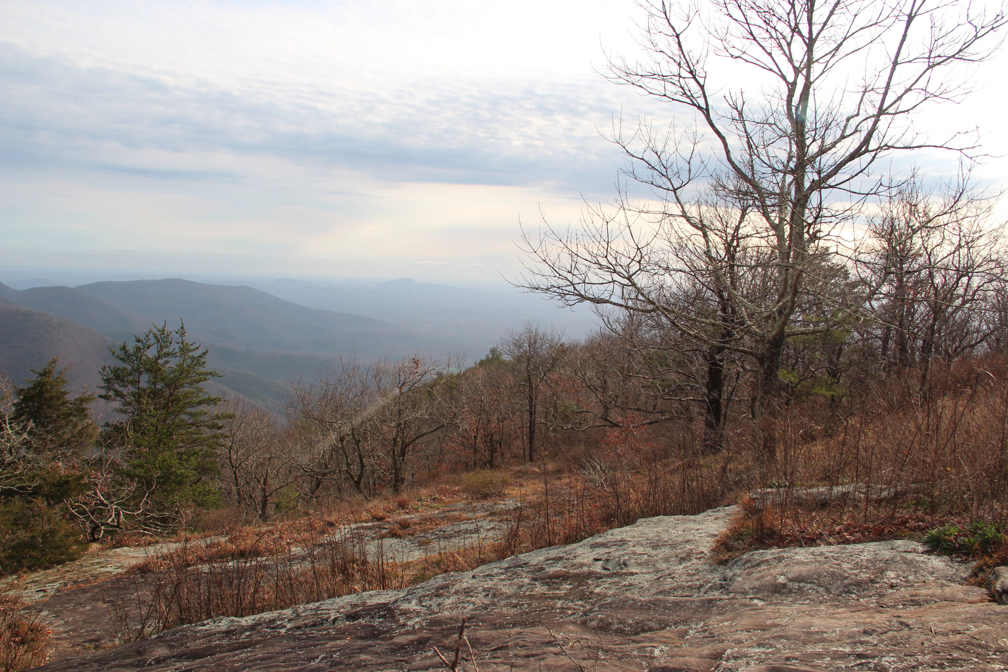
A wide mountain landscape view featuring a rocky foreground and bare trees under a cloudy sky.
A scenic overlook from the summit of Cowrock Mountain within the Raven Cliffs Wilderness.

Raven Cliffs Wilderness history and protected-area timeline

Raven Cliffs Wilderness was formally designated in 1986 as part of the National Wilderness Preservation System, drawing its protected status from a broader national effort during the 1980s to identify and preserve the highest-quality roadless areas remaining on federal forest lands. Its creation reflected both the ecological recovery of the surrounding Chattahoochee National Forest and a growing recognition that the cliffs, cascades, and recovering forests of this corner of Georgia deserved long-term protection from road building, logging, and commercial development.

Before its wilderness designation, the area had a very different character. Throughout the early to mid-1900s, the forests of Raven Cliffs were logged extensively, typical of the broader timber boom that swept across the southern Appalachians in that era. Cabin and sawmill-era cuttings left the slopes open and altered, but as commercial timbering receded from the region, the forest gradually recovered. The maturing second-growth stands visible today, where most individual hardwoods and scattered pines are now well into their seventh decade or beyond, are a direct legacy of that logging era and the subsequent halt in large-scale timber extraction.

Since 1986, the wilderness has been managed by the U.S. Forest Service with an emphasis on preserving its wilderness character, maintaining trail access to key scenic features, and protecting the integrity of its stream systems. Over time, it has grown into one of the more prominent wilderness destinations in northern Georgia, both for anglers drawn by its trout streams and for hikers attracted by its cliffs and waterfalls.

Raven Cliffs Wilderness landscape and geographic character

The landscape of Raven Cliffs Wilderness is shaped by the classic geology of the southern Blue Ridge, with steep ridges, narrow valleys, and exposed rock faces defining the terrain in a compact geographic footprint. The wilderness extends across roughly 9,115 acres of mountainous country, with elevations rising from approximately 1,800 feet along Boggs Creek to 3,846 feet at the summit of Levelland Mountain. This range gives the area a strong vertical relief, unusual within the state of Georgia, and produces an unusually varied terrain for a wilderness of its size.

The ridgelines form the spine of the wilderness, with peaks such as Levelland Mountain and Cowrock Mountain offering long views across the surrounding Chattahoochee National Forest. Between these summits, the slopes fall away sharply into shaded hollows where Boggs Creek and other streams have carved the underlying rock over time. It is along these slopes and hollow edges that the namesake cliffs emerge, sheer faces of exposed stone that mark some of the most dramatic scenery in northeastern Georgia.

Water defines much of the lower landscape. The cascading creeks tumble off the cliffs and through the boulder-strewn valleys below, producing the waterfalls and cascades, including the iconic Raven Cliff Falls, that anchor the area's reputation. These stream corridors give the wilderness a distinctive dual character: a high, exposed, rocky upper world of ridgelines and cliffs, and a low, cool, shaded lower world of running water and dense forest. Together, these features produce a landscape that feels larger and more varied than the area's acreage would suggest.

Raven Cliffs Wilderness ecosystems, habitats, and plant life

Raven Cliffs Wilderness preserves a substantial example of Southern Appalachian forest that has matured significantly since the abandonment of early twentieth-century logging. The dominant vegetative cover consists of dense hardwood stands, with oaks, hickories, and other typical Appalachian broadleaf species forming a rich canopy across most of the wilderness. Scattered pines rise above the hardwood layer, many of them now six decades old or older, giving the forest a multi-aged structure that contributes to both its habitat complexity and its scenic character.

Along the slopes and stream corridors, the forest transitions into more moisture-loving communities, with rhododendron and other understory shrubs contributing to the classic southern Appalachian cove forest aesthetic. Boggs Creek and its tributaries create ribbons of riparian habitat that thread through the wilderness, sustaining cool, shaded microclimates that are distinct from the drier, more exposed ridgelines above. These cold, well-oxygenated streams support the trout populations that have become an important element of the area's ecological identity.

Across the higher elevations and rock outcrops, drier and harder conditions create pockets of more resilient vegetation adapted to thin soils and sun exposure. The cliffs themselves host specialized plant communities that have adapted to the unique conditions of vertical rock faces, including crevice-dwelling species that depend on the moisture seeping through joints in the stone. Together, these varied habitats give Raven Cliffs an ecological richness that, while compact, reflects the broader patterns of the southern Blue Ridge.

Raven Cliffs Wilderness wildlife and species highlights

The wildlife of Raven Cliffs Wilderness reflects the broader species assemblage of the southern Appalachian mountains, with forest-dwelling mammals, abundant birdlife, and a healthy cold-water fishery. The dense hardwood canopy and connected tracts of mature forest provide reliable habitat for species typical of the region, including white-tailed deer, black bears, wild turkeys, and various small mammals that thrive in the understory and along the stream corridors. The mosaic of ridges, hollows, and cliffs produces enough habitat diversity to support a wide range of wildlife behavior patterns across relatively short distances.

Birdlife in the wilderness benefits from the layered forest structure, with mixed flocks of songbirds using the hardwood canopy, while raptors patrol the open ridges and cliff edges. The cliffs themselves are particularly important for cliff-nesting species, offering protected ledges where birds can breed away from ground-based predators. These rocky habitats form one of the more distinctive ecological features of the area from a wildlife perspective.

Boggs Creek and the broader network of approximately 41 miles of trout streams form the backbone of the area's aquatic wildlife story. Cold, clean water flowing through shaded forest corridors supports healthy populations of native and stocked trout, making these streams a focal point for both the wilderness's ecology and its recreational identity. The combination of terrestrial wildlife, birdlife, and a strong cold-water fishery gives Raven Cliffs a wildlife profile that feels complete and characteristic of the southern Appalachians.

Raven Cliffs Wilderness conservation status and protection priorities

Raven Cliffs Wilderness represents an important conservation success story in Georgia, both for the protection of its cliffs and waters and for the recovery of its forest ecosystem following early twentieth-century logging. Its designation in 1986 as part of the National Wilderness Preservation System ensured long-term protection from road construction, commercial logging, and other development, locking in the wilderness character of a landscape that had already begun to regrow into a mature forest.

From a conservation perspective, the wilderness's compact but ecologically diverse footprint is significant. The combination of high-elevation ridgelines, exposed rock cliffs, mature hardwood forest, and cold-water stream systems creates a refuge for species and habitat types that would be difficult to replicate elsewhere in the region. By remaining roadless and undeveloped, Raven Cliffs continues to function as a stronghold of native Appalachian ecological processes, including natural forest succession, undisturbed stream hydrology, and the predator-prey dynamics that depend on large, continuous habitat blocks.

The wilderness also plays an important role in protecting water quality in a southern Appalachian watershed. The heavily forested slopes act as a natural filter for rainfall, and the protected status of the area ensures that Boggs Creek and its tributaries remain in a more pristine condition than they might otherwise be, benefiting both aquatic species downstream and the broader Chattahoochee River system of which they are a part. In this sense, Raven Cliffs is valued not only as a scenic destination but as a functioning piece of regional ecological infrastructure.

Raven Cliffs Wilderness cultural meaning and human context

Raven Cliffs Wilderness sits within a region of northern Georgia traditionally tied to Appalachian mountain culture, where small communities developed around timber, agriculture, and later tourism. The early twentieth-century logging activity that shaped the forest also shaped the human history of the surrounding valleys, leaving behind a legacy of small mill towns, forest roads, and local knowledge of the mountains that persists in the regional culture today.

The wilderness itself does not contain major built features or inhabited sites, but its scenic attractions, particularly Raven Cliff Falls and the Raven Cliffs Scenic Area, have become important cultural touchstones for residents and visitors in northeastern Georgia. For local communities in Lumpkin, Union, and White Counties, the wilderness represents a shared natural landmark and a source of regional identity tied to the southern Appalachian landscape.

Top sights and standout views in Raven Cliffs Wilderness

The defining highlights of Raven Cliffs Wilderness are concentrated around its waterfalls, cliffs, and recovering forest. Raven Cliff Falls, dropping through a narrow cleft in the rock face, is the single most iconic feature and the visual centerpiece of the entire area, drawing visitors into the broader wilderness from the Raven Cliffs Scenic Area. Beyond the falls, the cliffs themselves form a continuous scenic thread, providing both dramatic views and specialized habitat for cliff-nesting wildlife and rocky-terrain plants.

Equally important are the area's roughly 41 miles of trout streams, which give the wilderness a cold-water backbone that supports both wildlife and recreational angling, and the ridgeline summits such as Levelland Mountain and Cowrock Mountain, which offer long views across the Chattahoochee National Forest. Together, these features combine to produce a wilderness that feels complete: a compact Appalachian landscape where cliffs, cascades, forests, and streams all reinforce one another in a way that few similarly sized protected areas in the southern mountains manage to achieve.

Best time to visit Raven Cliffs Wilderness

Raven Cliffs Wilderness is at its most visually striking in spring and autumn, when the southeastern Appalachian forest is at its most expressive. Spring brings high water to the falls and creeks, lush green foliage, and a vibrant understory of flowering shrubs along the stream corridors, making the waterfalls and forest scenery especially dramatic. Late summer, while warmer, can still be rewarding, with cooler temperatures at higher elevations and reliable trout fishing conditions in Boggs Creek and the broader stream network.

Autumn transforms the hardwood canopy into a vivid display of fall color, drawing visitors into the wilderness for leaf-peeping walks along the lower trails and around the scenic area. Winter visits are quieter and colder, with snow occasionally visible on the higher elevations, but access can be limited by weather, and the falls, while still running, tend to be less voluminous than in spring. Overall, spring and fall offer the broadest scenic reward, while summer provides the most consistent conditions for stream-based recreation.
Monthly climate preview

Long-term representative measurements and monthly weather patterns

Raven Cliffs Wilderness Climate Normals, Annual Temperature and Precipitation

Historical data for Raven Cliffs Wilderness records monthly average temperatures spanning from 3.72 degrees Celsius up to 25.52 degrees Celsius alongside consistent daily precipitation. Reviewing the complete twelve-month profile provides deeper insight into measured long-term climatological variations across the protected landscape.
Annual mean15 °C
4 °C26 °C
Jan
Feb
Mar10°
Apr14°
May19°
Jun23°
Jul26°
Aug25°
Sep21°
Oct15°
Nov
Dec
Warmest month
July

25.5 °C

Coolest month
January

3.7 °C

Wettest month
February

4.5 mm/day

Driest month
October

3.3 mm/day

Park location guide

Geography guide, regional context, and park location map for Raven Cliffs Wilderness

Raven Cliffs Wilderness park geography, regions, and map view in United States of America

Understand where Raven Cliffs Wilderness sits in United States of America through a broader geographic reading of the surrounding landscape, nearby location context, and its mapped position within the national park landscape.

How Raven Cliffs Wilderness fits into United States of America

The United States of America is a federal presidential republic and one of the world's largest countries by area and population. It consists of 50 states across a vast territory spanning multiple time zones, with its capital in Washington, D.C. and largest city in New York City. The nation has a diverse economy, influential political system, and significant cultural and military presence globally.

Wider geography shaping Raven Cliffs Wilderness in United States of America

The United States occupies a vast territory in North America, bordered by Canada to the north and Mexico to the south. The 48 contiguous states stretch from the Atlantic to the Pacific Ocean, while Alaska occupies the northwestern region and Hawaii is an archipelago in the Pacific. The country encompasses diverse terrain including the Rocky Mountains, Appalachian Mountains, Great Plains, and extensive river systems.

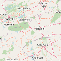
Map view of Raven Cliffs Wilderness

Use this park location map to pinpoint Raven Cliffs Wilderness in United States of America, understand its exact geographic position, and read its mapped placement within the surrounding landscape more clearly.

Pigeon | © OpenStreetMap contributors

Location context for Raven Cliffs Wilderness

Georgia
Recorded earthquake history

Review the Historical Earthquake Catalogue for Raven Cliffs Wilderness

Consult the recorded seismic history associated with the geography of Raven Cliffs Wilderness. This collection offers a clear look at past earthquake events using official catalogue data, providing context on the regional seismic background of these Georgia mountain landscapes.

Raven Cliffs Wilderness Earthquake History

Catalogued events

1 event

Strongest magnitude

Magnitude 3.2

Most recent event

Aug 1, 2009

This history includes earthquakes recorded inside the park or within 50 km of its borders

Visual reference guide to southern Appalachian terrain, cliffs, and waterfalls

Raven Cliffs Wilderness Photos, Landscapes, and Scenery Exploration

Visual records reveal the steep rock formations, cascading waterfalls, and dense hardwood canopies defining the protected terrain of Raven Cliffs Wilderness. Examining these protected area photographs provides direct insight into the rugged topography, cold water streams, and recovered mountain habitats of the southern Blue Ridge.

A wide mountain landscape view featuring a rocky foreground and bare trees under a cloudy sky.

Park atlas

Compare nearby national forests, wilderness tracts, and regional Appalachian landscapes.

Parks Near Raven Cliffs Wilderness and Surrounding Protected Areas

Browse other parks and protected areas near Raven Cliffs Wilderness to compare adjacent southern Appalachian mountain terrain. Continuing the geographic review helps map surrounding high-country forests, ridgelines, and stream corridors across the region.
A soft watercolor illustration depicting a landscape of rolling hills and mountain silhouettes in shades of green, yellow, and faint red against a white background.
Protected landscapeGeorgia
About 28 km away#1 closest

West

Ed Jenkins National Recreation Area and Southern Appalachian Mountain Geography

Protected forested ridges and trail gateway in northern Georgia

Covering over 23,000 acres, this protected area features the iconic southern terminus of the Appalachian Trail at Springer Mountain. The unit preserves a dense tapestry of hardwood forests, rolling ridges, and spring-fed stream valleys, representing a core portion of the Blue Ridge mountain range's continuous landscape in northern Georgia.

Area
94.4 km²
Established
1991
Relief
Mountain
Climate
Temperate
A horizontal watercolor painting depicting a soft green landscape with rolling hills, a meandering stream, and foreground grasses against a light white background.
Protected landscapeNorth Carolina
29 km away#2 closest

Northeast

Nantahala National Forest: Geographic Overview of Protected Appalachian Mountain Landscapes

Mapping deep river gorges and temperate rainforests in North Carolina

The Nantahala National Forest represents a significant conservation achievement, encompassing diverse southern Appalachian mountain terrain. The landscape features deep river gorges, ancient old-growth forests, and extensive networks of waterfalls. This overview provides mapped context on its vast wilderness areas, including Joyce Kilmer-Slickrock, and the long-distance trail corridors that traverse this temperate rainforest region.

Area
2,150 km²
Established
1920
Relief
Mountain
Climate
Temperate
A wide watercolor painting showing a landscape of green rolling hills with trees in the foreground and layers of purple mountains in the background against a white background.
Protected areaGilmer County
32 km away#3 closest

West

Rich Mountain Wilderness: Mapping Appalachian Ridges and Protected Terrain in Georgia

Explore the high-elevation forests of Gilmer County.

Rich Mountain Wilderness encompasses nearly 9,500 acres of undisturbed Appalachian mountain landscape. Characterized by its signature 4,050-foot peak and unique porter's loam soils, the area supports a diverse forest ecosystem shielded under federal wilderness protection within the Chattahoochee National Forest.

Area
38.35 km²
Established
1986
IUCN
Ib
Relief
Mountain
Protected landscapeSouth Carolina
41 km away#4 closest

East

Sumter National Forest: Mapping Protected Landscapes and Terrain in South Carolina

Bridging Piedmont forests and Appalachian mountain foothills

Sumter National Forest offers a study in geographic contrast, as its three districts span the transition from South Carolina Piedmont ridges to the rugged spurs of the Blue Ridge Mountains. This protected area features the Chattooga Wild and Scenic River corridor, expansive hardwood-conifer mosaics, and complex mountain watersheds. The forest provides a window into regional land restoration, where reclaimed farmland and mountain ridges now form a continuous network of protected natural terrain.

Area
1,500.98 km²
Established
1936
Relief
Mixed relief
Climate
Temperate
A pale, soft-focus watercolor painting showing a river with gentle banks and distant hills, with tree branches hanging in the top right corner.
Protected landscapeGeorgia
62 km away#5 closest

Southwest

Chattahoochee River National Recreation Area: Protected Landscape Map and Regional Geography

River corridors, Piedmont forest, and historic tributary gorges

This protected landscape in northern Georgia preserves a vital 48-mile corridor along the Chattahoochee River. The terrain shifts from vertical palisade cliffs to wide shoals and forested tributary gorges, weaving through the metropolitan landscape of Atlanta. The area serves as a significant regional anchor for natural river ecosystems and historic industrial remnants.

Area
42.69 km²
Established
1978
IUCN
V
Visitors
3.5M annual
A soft watercolor illustration depicting a winding river, a small waterfall over layered rocks, and distant rolling mountains in muted green, blue, and brown tones.
Wildlife reserveUnited States of America
67 km away#6 closest

Northeast

Ellicott Rock Wilderness: Geographic and Historic Protected Landscape Overview

A rare tri-state wilderness in the Southern Appalachian Mountains

Discover the mapped terrain of Ellicott Rock Wilderness, a protected area defined by its steep river gorges, dense cove forests, and unique position at the tripoint of three U.S. states. This wilderness area preserves the Chattooga River corridor and historic survey landmarks within the southern Blue Ridge Mountains, offering deep insight into the regional geography of the American southeast.

Area
33.48 km²
Established
1975
IUCN
Ib
Relief
Mountain
A horizontal watercolor painting showing a soft, impressionistic landscape with mature trees in the foreground, rolling green hills in the midground, and faded purple mountain silhouettes in the distance against a white background.
Wildlife reserveNorth Carolina
67 km away#7 closest

North

Joyce Kilmer-Slickrock Wilderness: Mapped Topography and Protected Forest Boundaries

Old-growth Appalachian wilderness in North Carolina

Analyze the dramatic valley-and-ridge geography of the Joyce Kilmer-Slickrock Wilderness. This protected area, encompassing the rare Joyce Kilmer Memorial Forest, serves as a vital reference for eastern forest conservation, featuring ancient hardwood groves and sweeping mountain vistas across the Unicoi range.

Area
70 km²
Established
1975
IUCN
Ib
Relief
Mountain
Wildlife reserveTennessee
78 km away#8 closest

Northwest

Gee Creek Wilderness: Geographic Atlas of an Appalachian Forested Wildlife Reserve

Protected mountain terrain in the Tennessee foothills

Gee Creek Wilderness is a federally protected area in southeastern Tennessee characterized by its small, roadless footprint and rich Appalachian forest composition. The reserve showcases the dramatic intersection of forested ridgelines and stream-carved valleys, providing a concentrated look at the ecological character of the Cherokee National Forest's lower Appalachian zone.

Area
10.09 km²
Established
1975
IUCN
Ib
Relief
Upland

Common questions about visiting, size, designation, and location context for Raven Cliffs Wilderness

Raven Cliffs Wilderness FAQs for park facts, access, geography, and protected area context

Find quick answers about Raven Cliffs Wilderness, including protected-area facts, park geography, trail and visitor context, and how the park fits into its surrounding country and regional landscape.
MoriAtlas Explorer

Continue Your Protected Areas Search Across the Global Atlas

Deepen your exploration by continuing the structured search for national parks and protected areas worldwide. Utilize the comprehensive filtering capabilities to compare different conservation landscapes and refine your understanding of global park geography. Discover more about the distribution and characteristics of protected natural areas.

Global natural geography