Mori Atlas logo
Wildlife reserveRed Mountain Wilderness

Mapping the geological structures and mixed desert plant communities of a unique wildlife reserve

Red Mountain Wilderness: A Protected Navajo Sandstone Landscape in Southwestern Utah

Red Mountain Wilderness serves as a prominent sandstone massif in southwestern Utah, where the Mojave Desert meets the Great Basin. This protected area centers on the striking red Navajo sandstone block bounded by the Gunlock Fault and the Santa Clara River valley. The terrain features a complex mix of slickrock benches, sandy washes, and cliff-bound drainages, supporting an unusual blend of hot-desert and cool-desert plant species. Archaeological sites throughout the canyons and high ground reflect a long history of human presence in this rugged landscape.

wildernessred sandstoneNavajo sandstoneMojave DesertGreat Basindesert vegetation

Red Mountain Wilderness

Wildlife reserve

Park overview

Structured park overview, official facts, and landscape profile for Red Mountain Wilderness (Utah)

Red Mountain Wilderness (Utah) park facts, protected area profile, and essential visitor context

Review the core facts for Red Mountain Wilderness (Utah), including designation, size, terrain, visitor scale, habitats, and operating context in one park-focused overview.

About Red Mountain Wilderness (Utah)

Red Mountain Wilderness is a Bureau of Land Management wilderness area in the far southwestern corner of Utah, set within the broader desert landscape of Washington County. Its central feature is Red Mountain itself, a bold upthrust of red Navajo sandstone that dominates the surrounding terrain and gives the protected area its name. The mountain is bounded on the west by the Gunlock Fault, and on the south and east by the Santa Clara River valley and Snow Canyon.

Designated as wilderness in 2009 as part of the Omnibus Public Land Management Act, the area covers approximately 18,729 acres. Roughly half of the wilderness footprint lies inside the neighboring Red Cliffs National Conservation Area, creating a larger connected landscape of conservation lands in the region. Snow Canyon State Park lies along its eastern edge, while the Shivwitz (Shivwits) Indian Reservation sits to the southwest, placing the wilderness within a culturally and ecologically layered part of southern Utah.

The location sits at a critical ecological crossroads. The mixing of species from the warm Mojave Desert to the south and the cooler Great Basin to the north gives the wilderness an unusually diverse vegetation profile for its size, drawing together plants that would not normally share the same slope. Beyond its natural character, the area holds documented evidence of prehistoric Southern Paiute use across multiple archaeological sites, underlining its long human history as well as its scenic and ecological value.

Quick facts and research context for Red Mountain Wilderness (Utah)

Red Mountain Wilderness covers roughly 18,729 acres in Washington County, southwestern Utah, and was designated as wilderness on March 30, 2009 through the Omnibus Public Land Management Act of 2009. It is administered by the Bureau of Land Management and classified as IUCN Category Ib, denoting a legally protected wilderness area where ecological processes are largely undisturbed. The nearest town is Ivins, Utah, with St. George lying several miles to the southwest.

Around half of the wilderness is included within the Red Cliffs National Conservation Area, reinforcing its role as part of a broader landscape-scale protection strategy in the region. The area sits at the meeting point of the Mojave and Great Basin deserts, and archaeological surveys by the BLM have documented multiple prehistoric Southern Paiute sites.

Protection and recognition

Explore the documented conservation scope and administrative background of this protected area.

Red Mountain Wilderness Protection Status and Territorial Designation

Red Mountain Wilderness maintains a terrestrial protection scope within its designated landscape boundaries. Available records detail the administrative framework and conservation status governing the protected terrain.

Protection details

Protection scope
Terrestrial
Transboundary protection
No
Park context

Deeper park guide and search-rich context for Red Mountain Wilderness (Utah)

Red Mountain Wilderness (Utah) history, landscape, wildlife, and travel context

Explore Red Mountain Wilderness (Utah) through its history, landscape character, ecosystems, wildlife, conservation priorities, cultural context, and seasonal travel timing in a structured park guide built for atlas discovery and search intent.

Why Red Mountain Wilderness (Utah) stands out

Red Mountain Wilderness is especially known for the vivid red Navajo sandstone block from which it takes its name, standing out as a dramatic mass of color against the surrounding desert landscape. It is closely associated with Snow Canyon, the Santa Clara River valley, and the Gunlock Fault, the geological structures that shape the mountain's boundaries. Ecologically, it is recognized for the unusual mixing of Mojave and Great Basin plant communities, producing a blend of hot-desert and cool-desert flora on the same slopes. The wilderness is also notable for its role within the larger Red Cliffs conservation landscape and for the presence of prehistoric Southern Paiute archaeological sites scattered through the canyons and high ground. Together, these features combine geology, mixed desert ecology, and deep human history into a relatively compact protected area.
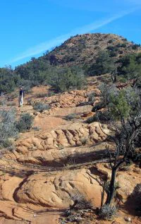
A desert landscape showing a red sandstone hill with rocky terrain, scrubby desert trees, and bushes under a clear blue sky.
A rocky desert hillside featuring red sandstone formations and sparse vegetation within the Red Mountain Wilderness.

Red Mountain Wilderness (Utah) history and protected-area timeline

Red Mountain Wilderness has a relatively recent formal history as a protected area, with its wilderness designation established on March 30, 2009. That designation came through the Omnibus Public Land Management Act of 2009, a major federal law that added and expanded protected lands across the American West. The Bureau of Land Management became the managing agency for the area, and it was classified as a Category Ib wilderness under the IUCN protected-area framework.

Long before this modern designation, the area was used by the Southern Paiute people. Archaeological surveys have identified seven prehistoric sites within what is now the wilderness, and broader inventories by the BLM suggest archaeological site densities of roughly 4 to 40 sites per square mile. Red Mountain itself takes its name from local settlement and geographic tradition rather than from any later official act, but the area had been informally recognized as a striking natural landmark for decades before gaining formal wilderness status. Its more recent inclusion within the Red Cliffs National Conservation Area has tied its history to broader regional conservation planning in southwestern Utah.

Red Mountain Wilderness (Utah) landscape and geographic character

Red Mountain Wilderness centers on a single dominant landform: Red Mountain, a massive block of Navajo sandstone lifted above the surrounding plateau. The mountain's western flank is defined by the Gunlock Fault, while its southern and eastern faces drop toward the Santa Clara River valley and Snow Canyon. The resulting configuration is a tall, brightly colored sandstone massif rising out of a matrix of desert valleys, lava-capped mesas, and shallow canyons.

The surrounding terrain is a mixture of slickrock benches, sandy washes, and cliff-bound drainages typical of the transition zone between the Mojave Desert and the Colorado Plateau. Because the mountain stands between Snow Canyon State Park and the lands around the Shivwitz (Shivwits) Indian Reservation, the viewscapes are unusually rich, alternating between narrow sandstone narrows, open juniper flats, and views across the Santa Clara drainage. The terrain produces a landscape that feels both empty and varied, with abrupt shifts from exposed red rock to shadier canyons where soils and moisture support denser vegetation.

Red Mountain Wilderness (Utah) ecosystems, habitats, and plant life

Red Mountain Wilderness lies where the warm Mojave Desert to the south and the cooler Great Basin to the north overlap, and this meeting point is the defining ecological feature of the area. The mixing of these two bioregions gives the wilderness a plant assemblage more diverse than most landscapes of comparable size, with several typically separate desert communities growing side by side on the same slopes.

Vegetation on the mountain and its surroundings includes pinyon pine and juniper woodlands, along with sagebrush flats, ponderosa pine in cooler pockets, and characteristic Mojave species such as yucca and agave. Gambel oak appears in transitional zones, contributing to a mosaic that shifts with elevation, aspect, and soil. This blend of Mojave warmth and Great Basin coolness gives the area a layered, almost hybrid feel, where visitors can see cactus-dominated flats and conifer woodland within the same general view.

Red Mountain Wilderness (Utah) wildlife and species highlights

Wildlife in Red Mountain Wilderness reflects both the desert setting and the proximity of Snow Canyon and the Santa Clara River corridor. The most commonly noted large mammals are mule deer, which move through the canyons and benches, and mountain lions, the area's primary large predator. Raptors are among the most visible wildlife, with peregrine falcon and bald eagle regularly associated with the area, using the cliffs and canyons for nesting and hunting.

Because the wilderness connects with Snow Canyon State Park and the broader Red Cliffs landscape, wildlife here is part of a wider regional network of habitat for desert and canyon-dwelling species. The combination of cliffs, washes, and shrub-grassland mosaic supports a mix of mammals, birds, and reptiles typical of southwestern Utah's desert-edge environments.

Red Mountain Wilderness (Utah) conservation status and protection priorities

Red Mountain Wilderness is significant from a conservation standpoint for three layered reasons: its formal wilderness protection, its overlap with the Red Cliffs National Conservation Area, and its location at the Mojave-Great Basin transition. The 2009 wilderness designation locks in a high level of protection, restricting development and motorized use to preserve the area's ecological character. The Bureau of Land Management's stewardship classification as IUCN Category Ib reinforces the area's status as a landscape where natural processes are intended to dominate.

The partial overlap with the Red Cliffs National Conservation Area brings additional conservation focus, connecting the wilderness to a broader landscape of protected lands designed to safeguard desert ecosystems, scenic resources, and cultural sites in southwestern Utah. Together, these protections help maintain a connected network of habitat that supports desert wildlife, preserves vegetation communities that straddle two major bioregions, and protects the prehistoric Southern Paiute archaeological record from the pressures of nearby St. George-area growth.

Red Mountain Wilderness (Utah) cultural meaning and human context

The Red Mountain Wilderness area has a long human history reflected in its prehistoric archaeological record. The Southern Paiute people used the landscape that now includes the wilderness, and archaeological surveys have documented seven known prehistoric sites within the area. Broader inventories from the Bureau of Land Management suggest that the surrounding region holds between 4 and 40 archaeological sites per square mile, underlining the density of cultural heritage in this part of southwestern Utah.

The presence of the Shivwitz (Shivwits) Indian Reservation immediately to the southwest further reinforces the ongoing cultural significance of the area to the Southern Paiute people. Today, the wilderness sits within a wider cultural landscape that also includes the modern communities of St. George and Ivins, making the protected area a meeting point of ancient land-use history and contemporary southwestern Utah life.

Top sights and standout views in Red Mountain Wilderness (Utah)

Red Mountain Wilderness offers a compact but striking combination of red sandstone scenery, mixed-desert ecology, and deep human history. Its central feature is the red Navajo sandstone mass of Red Mountain, framed by the Gunlock Fault and the Santa Clara River valley. The wildlife profile adds further weight: mule deer, mountain lions, peregrine falcons, and bald eagles are all characteristic species within the wilderness.

The wilderness also stands out for its connection to Snow Canyon and the broader Red Cliffs conservation landscape, its position at the crossing point between the Mojave and Great Basin floras, and the presence of documented Southern Paiute archaeological sites scattered across its canyons and high ground.

Best time to visit Red Mountain Wilderness (Utah)

Red Mountain Wilderness sits in southwestern Utah's high desert, where summers can be hot and winters relatively mild but occasionally cold. Spring and autumn tend to offer the most balanced conditions for experiencing the area, with cooler temperatures for hiking the sandstone terrain and more active wildlife movement through the canyons. Winter can be rewarding for those interested in solitude and sharper views of the red rock, while summer visits are best planned for cooler parts of the day because of strong desert heat.

Seasonal conditions also affect how the vegetation reads on the landscape; spring growth can briefly emphasize the area's mix of Mojave and Great Basin plants, while late summer and fall tend to bring clearer sightlines across the Gunlock Fault zone and toward Snow Canyon. Visitors interested in raptors such as peregrine falcons and bald eagles may find the cooler months productive, when cliff and canyon activity is more visible.
Monthly climate preview

Monthly temperature averages and precipitation measurements for Red Mountain Wilderness

Red Mountain Wilderness Climate Normals: Annual Temperature and Precipitation Records

Representative coordinates record measured monthly temperature swings alongside long term precipitation patterns across the protected landscape. Examining the complete twelve month climate profile reveals detailed temperature and precipitation normals for Red Mountain Wilderness.
Annual mean16 °C
4 °C30 °C
Jan
Feb
Mar11°
Apr15°
May20°
Jun27°
Jul30°
Aug29°
Sep24°
Oct17°
Nov
Dec
Warmest month
July

29.8 °C

Coolest month
December

4.2 °C

Wettest month
February

1.3 mm/day

Driest month
June

0.2 mm/day

Park location guide

Geography guide, regional context, and park location map for Red Mountain Wilderness (Utah)

Red Mountain Wilderness (Utah) park geography, regions, and map view in United States of America

Understand where Red Mountain Wilderness (Utah) sits in United States of America through a broader geographic reading of the surrounding landscape, nearby location context, and its mapped position within the national park landscape.

How Red Mountain Wilderness (Utah) fits into United States of America

The United States of America is a federal presidential republic and one of the world's largest countries by area and population. It consists of 50 states across a vast territory spanning multiple time zones, with its capital in Washington, D.C. and largest city in New York City. The nation has a diverse economy, influential political system, and significant cultural and military presence globally.

Wider geography shaping Red Mountain Wilderness (Utah) in United States of America

The United States occupies a vast territory in North America, bordered by Canada to the north and Mexico to the south. The 48 contiguous states stretch from the Atlantic to the Pacific Ocean, while Alaska occupies the northwestern region and Hawaii is an archipelago in the Pacific. The country encompasses diverse terrain including the Rocky Mountains, Appalachian Mountains, Great Plains, and extensive river systems.

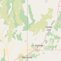
Map view of Red Mountain Wilderness (Utah)

Use this park location map to pinpoint Red Mountain Wilderness (Utah) in United States of America, understand its exact geographic position, and read its mapped placement within the surrounding landscape more clearly.

Pigeon | © OpenStreetMap contributors

Location context for Red Mountain Wilderness (Utah)

Utah
Recorded earthquake history

View Recorded Earthquake History Near Red Mountain Wilderness

Investigate the history of recorded seismic events in the vicinity of Red Mountain Wilderness. MoriAtlas provides a clear, structured overview of regional earthquake data, allowing for deeper engagement with the tectonic geography surrounding this protected Utah landscape.

Red Mountain Wilderness Earthquake History

Catalogued events

45 events

Strongest magnitude

Magnitude 5.9

Most recent event

Jul 21, 2020

This history includes earthquakes recorded inside the park or within 50 km of its borders

Explore protected area photography, Navajo sandstone formations, and desert habitats.

Red Mountain Wilderness Photos and Landscape Scenery Visual Guide

Visual records capture the striking red Navajo sandstone massifs, rugged canyons, and distinct Mojave Desert transition zones defining Red Mountain Wilderness. Examining these protected area photographs reveals the unique geological features, mixed desert flora, and expansive terrain character of the region.

A desert landscape showing a red sandstone hill with rocky terrain, scrubby desert trees, and bushes under a clear blue sky.

Park atlas

Compare regional desert terrain, sandstone massifs, and connected conservation lands

Parks Near Red Mountain Wilderness and Surrounding Protected Areas

Visitors exploring Red Mountain Wilderness can browse adjacent protected areas and nearby desert reserves to compare surrounding regional geography. Examining connected conservation landscapes provides broader context on transitional Mojave and Great Basin ecosystems.
National parkUtah
41 km away#1 closest

East

Zion National Park National Park: Detailed Mapped Geography and Protected Landscape Identity

Explore the mapped terrain and regional context of this Utah national park.

Zion National Park represents a key protected area within Utah, ideal for detailed geographic exploration. This canonical page offers insights into the park's specific mapped boundaries, its inherent landscape character, and its regional geographic setting. It is designed for users seeking to understand the atlas-level significance of Zion National Park as a national park entity, focusing on its protected terrain and natural geography.

Area
593.26 km²
Established
1919
IUCN
II
Visitors
4.9M annual
Wildlife reserveWashington County
About 52 km away#2 closest

Northeast

LaVerkin Creek Wilderness: Mapping Protected Landscapes in Southwestern Utah

Wildlife reserve and watershed protection in Washington County

This protected area unit serves as a critical buffer for the upper LaVerkin Creek corridor. Its terrain spans the transition from high-elevation forested plateaus to deeply carved sedimentary canyons. By maintaining an unroaded status, the wilderness preserves essential riparian habitats and geological features that define the character of the surrounding southwestern Utah plateau region.

Area
1.8 km²
Established
2009
IUCN
Ib
Relief
Highland
A watercolor painting showing a soft-toned landscape with a winding river in the foreground, a forested middle ground, and rolling mountains in the distance.
Protected landscapeUnited States of America
86 km away#3 closest

Southwest

Lake Mead National Recreation Area: Desert Reservoir and Protected Landscape Atlas

United States protected geography and reservoir terrain

Spanning the lower Colorado River, Lake Mead National Recreation Area represents a unique convergence of desert ecosystems and large-scale water management. Its geography includes extensive reservoir shorelines, deep canyon corridors, and volcanic basin terrain that provide a foundational look at the arid environments of the American Southwest. The area remains a significant study of how engineered water features alter and interact with complex desert landscapes.

Area
6,053.31 km²
Established
1936
IUCN
V
Visitors
6.4M annual
Watercolor painting of a forested landscape featuring pine trees and distant rolling mountains on a white background.
Wildlife reserveArizona
94 km away#4 closest

Southeast

Mount Trumbull Wilderness: A Detailed Geographic Overview of Northern Arizona Volcanic Protected Lands

Mapping basalt mesas and cinder cone ecosystems on the Uinkaret Plateau

Mount Trumbull Wilderness represents a distinct volcanic protected area located on the Uinkaret Plateau of the Arizona Strip. This rugged wilderness encompasses a massive basalt-capped mesa, scattered cinder cones, and deep ecological gradients ranging from pinyon-juniper woodlands to ancient ponderosa forests, providing a vivid look at the complex geological history near the Colorado River.

Area
31 km²
Established
1984
IUCN
Ib
Relief
Mountain
National parkArizona
103 km away#5 closest

Southeast

Grand Canyon National Park: Arizona National Park Protected Landscape & Geography

Explore mapped boundaries and regional atlas context.

Grand Canyon National Park stands as a premier national park, showcasing a unique protected landscape within Arizona's diverse geography. This detailed entry focuses on the park's specific geographic identity, its mapped boundaries, and its significance within the regional atlas. Discover the contours of this protected area and its place in the natural terrain of the American Southwest.

Area
4,926.08 km²
Established
1919
IUCN
II
Visitors
4.9M annual
A horizontal watercolor illustration showing a calm lake in the foreground, surrounded by grassy banks, evergreen trees, and rolling mountains in the distance under a pale sky.
Protected landscapeArizona
104 km away#6 closest

Southeast

Kaibab National Forest: Protected Plateau Landscapes and Forested Geography in Arizona

High-elevation forest terrain bordering the Grand Canyon

Spanning over 1.6 million acres in Arizona, Kaibab National Forest is characterized by its split geographic configuration, with distinct sections flanking the North and South rims of the Grand Canyon. The terrain ranges from the high-altitude Kaibab Plateau to volcanic uplands near Williams, encompassing four designated wilderness areas and varied forest ecosystems that provide a critical buffer for the surrounding canyon country.

Area
6,500 km²
Established
1909
Relief
Mountain
Climate
Temperate
A minimalist watercolor painting depicting a pale desert landscape with soft green hills and light reddish rock formations against a white background.
Wildlife reserveArizona
107 km away#7 closest

Southeast

Kanab Creek Wilderness: Protected Canyon Landscapes and Geography of Northern Arizona

Extensive tributary canyon systems and plateau terrain

Kanab Creek Wilderness represents a vast protected area in northern Arizona, defined by deep gorges and vertical cliffs etched into the Kanab and Kaibab Plateaus. This geographic atlas entry provides insights into the canyon network that feeds the Colorado River, highlighting the extreme elevation gradients and archaeological significance of this rugged wilderness.

Area
305 km²
Established
1984
IUCN
Ib
Relief
Upland
Wildlife reserveClark County
About 120 km away#8 closest

South

Jumbo Springs Wilderness: Geographic Profile and Protected Landscape Atlas

A rugged desert preserve in Clark County, Nevada

Jumbo Springs Wilderness preserves a dense concentration of desert geology within a compact footprint. Users can analyze the protected boundaries, which feature Precambrian metamorphic formations and granitic domes that rise above arid drainages. This area functions as a critical desert refuge near the Lake Mead reservoir, providing a distinct look at the transition between rocky mountain slopes and water-influenced desert microhabitats.

Area
18.74 km²
Established
2002
IUCN
Ib
Relief
Upland

Common questions about visiting, size, designation, and location context for Red Mountain Wilderness (Utah)

Red Mountain Wilderness (Utah) FAQs for park facts, access, geography, and protected area context

Find quick answers about Red Mountain Wilderness (Utah), including protected-area facts, park geography, trail and visitor context, and how the park fits into its surrounding country and regional landscape.
MoriAtlas Explorer

Continue Your Protected Areas Search Across the Global Atlas

Deepen your exploration by continuing the structured search for national parks and protected areas worldwide. Utilize the comprehensive filtering capabilities to compare different conservation landscapes and refine your understanding of global park geography. Discover more about the distribution and characteristics of protected natural areas.

Global natural geography