Mori Atlas logo
Nature reserveRed Rock Lakes Wilderness

Mapping the expansive marshes and lake systems of this unique Northern Rockies nature reserve.

Red Rock Lakes Wilderness: A High Elevation Wetland Protected Area in Beaverhead County, Montana

Red Rock Lakes Wilderness occupies a remote high-elevation basin in the southwest corner of Montana, serving as a primary protected landscape within the larger national wildlife refuge system. The geography is defined by a chain of shallow lakes, sedge-filled meadows, and forested ridges that store vital water across the Continental Divide. This nature reserve provides an essential habitat for diverse wildlife, preserved through its designation as a significant protected wilderness area.

wilderness areawetlandsmarshlandhigh elevationmontanawildlife refuge

Red Rock Lakes Wilderness

Nature reserve

Park overview

Structured park overview, official facts, and landscape profile for Red Rock Lakes Wilderness

Red Rock Lakes Wilderness park facts, protected area profile, and essential visitor context

Review the core facts for Red Rock Lakes Wilderness, including designation, size, terrain, visitor scale, habitats, and operating context in one park-focused overview.

About Red Rock Lakes Wilderness

Red Rock Lakes Wilderness is a federally designated wilderness area that overlays most of the Red Rock Lakes National Wildlife Refuge in southwestern Montana. It represents a relatively rare situation in the American protected-area system: a refuge created primarily to safeguard a single species of waterfowl, layered with a wilderness designation that further restricts human activity across the same ground.

The setting is high and quiet. The wilderness sits in a broad mountain valley on the eastern side of the Continental Divide, where water collects in a chain of shallow lakes, wet meadows, and beaver-influenced marshes. Cold winters and short, mild summers shape both the vegetation and the behavior of the wildlife that depends on the area. Forests of lodgepole pine, spruce, and fir ring the open basins, while the wetland interiors remain dominated by sedges, willows, and aquatic plants.

For all of this, what truly defines Red Rock Lakes Wilderness is its function as a refuge. It is managed by the U.S. Fish and Wildlife Service, not by a forest service or land management agency, and its rules reflect that. There are no roads through the wilderness, no motor vehicles, no bicycles, no logging, and no mining. Mechanized access is barred under the terms of the 1964 Wilderness Act, and the landscape is allowed to function with as little direct human interference as possible.

Visitors encounter a place where wildlife tends to dictate the experience. Wading birds stalk the marsh edges, waterfowl rest on lakes that reflect the surrounding ridges, and large mammals move through willow thickets and forest margins. The wilderness' position on the western fringe of the Greater Yellowstone Ecosystem ties it to a larger regional story of predator-prey dynamics, ungulate migrations, and connected habitat, even though the area itself is better known for its wetlands than for its forests.

In practical terms, the wilderness can be appreciated through short walks into the surrounding meadows and lake edges, wildlife observation from pullouts and trails on the refuge, and longer hikes along routes that quickly leave signs of development behind. There are no campgrounds inside the wilderness, but primitive camping is allowed within the broader refuge, with two nearby campgrounds providing options for those who want to stay overnight.

Quick facts and research context for Red Rock Lakes Wilderness

Red Rock Lakes Wilderness lies in Beaverhead County in southwestern Montana, with the nearest town being Dillon. It occupies more than three fourths of the Red Rock Lakes National Wildlife Refuge and was formally designated as wilderness in 1976 under the framework of the 1964 Wilderness Act.

The wilderness is administered by the U.S. Fish and Wildlife Service rather than by a national forest or land management agency, which is reflected in the strict protection of its wetlands and waterfowl habitat. It sits on the western edge of the broader Greater Yellowstone Ecosystem, linking it ecologically to the large network of protected wildlands that stretch across the Montana-Wyoming border region.

Protection and recognition

Examine documented terrestrial conservation frameworks and official area designations.

Red Rock Lakes Wilderness Protection Status and International Recognition

Red Rock Lakes Wilderness maintains a documented terrestrial protection scope within its designated conservation framework. Analysis of available records provides structured insight into the management context and international recognition history associated with the protected landscape.

Protection details

Protection scope
Terrestrial
Transboundary protection
No
Park context

Deeper park guide and search-rich context for Red Rock Lakes Wilderness

Red Rock Lakes Wilderness history, landscape, wildlife, and travel context

Explore Red Rock Lakes Wilderness through its history, landscape character, ecosystems, wildlife, conservation priorities, cultural context, and seasonal travel timing in a structured park guide built for atlas discovery and search intent.

Why Red Rock Lakes Wilderness stands out

Red Rock Lakes Wilderness is most recognized for its role in saving the trumpeter swan from near-extinction in the lower 48 states. By the mid-1930s only about 69 trumpeter swans were estimated to remain in the contiguous United States, and more than half of them were found in what is today this wilderness, making it arguably the single most important refuge for the species at that moment. Beyond the swan story, the wilderness is appreciated for its expansive high-country wetlands, including Upper and Lower Red Rock Lake, Headwaters Lake, and a network of marshes and wet meadows. The combination of relatively undisturbed lakes, slow-moving streams, and open water in a high-elevation setting is the defining ecological signature of the area.
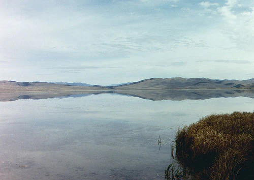
A wide, eye level landscape shot of a calm, reflective lake under a pale blue sky, with grassy marshes in the foreground and rounded, distant mountains across the horizon.
A calm, reflective view of Upper Red Rock Lake within the Red Rock Lakes Wilderness, showing marshy foreground vegetation and distant mountains.

Red Rock Lakes Wilderness history and protected-area timeline

The history of Red Rock Lakes Wilderness begins not as a wilderness designation but as a wildlife refuge born out of urgency. In the early twentieth century, the trumpeter swan had been hunted and pushed close to local extinction in the contiguous United States. By the mid-1930s, the total population in the lower 48 states had fallen to roughly 69 birds, and surveys at the time found that more than half of that remnant population was concentrated in the Red Rock Lakes area of southwestern Montana.

That discovery prompted one of the earliest deliberate attempts in the United States to set aside habitat specifically to recover an endangered species. The site was first protected as a game preserve and later reorganized as the Red Rock Lakes National Wildlife Refuge, giving managers authority to restrict hunting, control land use, and manage water levels in ways that favored swans and the broader wetland community.

In 1976, the U.S. Congress designated much of this refuge as wilderness under the 1964 Wilderness Act, formalizing an even higher level of protection across more than three quarters of the refuge. The wilderness designation added legal guarantees against motorized access, road construction, logging, and mining, building on the foundation that the original refuge had already provided.

The result is a landscape with a layered story of conservation: a refuge created to save a swan from disappearing, expanded into a wilderness designed to keep the habitat itself free from modern development. For an area of its size, Red Rock Lakes carries an unusually large weight in the broader narrative of American wildlife conservation.

Red Rock Lakes Wilderness landscape and geographic character

Red Rock Lakes Wilderness is a high-elevation basin country, centered on a chain of lakes and wetlands surrounded by forested ridges and open meadows. The highest lake in the system, Upper Red Rock Lake, sits in a broad, shallow basin that fills with snowmelt each spring and remains open well into the autumn. Lower Red Rock Lake and other smaller lakes and ponds extend the wetland complex down through the refuge, connected by slow streams, beaver-built channels, and seasonally flooded meadows.

The terrain alternates between flat and gently rolling wetland surfaces and the steeper slopes of the surrounding mountains. The Continental Divide rises to the west, while more modest ranges and forested ridges frame the refuge on its other sides. Lodgepole pine and subalpine fir dominate the forested slopes, giving way to willows, sedges, and wet-ground grasses where water takes over the land.

The visual impression is of open, reflective water, soft shorelines, and broad skies rather than dramatic peaks. Visitors encounter a landscape shaped more by water and weather than by bedrock and cliffs, and the wetland character of the valley is the dominant feature of the wilderness.

Red Rock Lakes Wilderness ecosystems, habitats, and plant life

Ecologically, Red Rock Lakes Wilderness is defined by its wetland systems. The lakes, marshes, and wet meadows form a mosaic of shallow water, emergent vegetation, and saturated soils that supports a distinctive high-elevation community of plants and animals. Willows, sedges, and aquatic plants dominate the open water margins, while coniferous forests of lodgepole pine, Engelmann spruce, and subalpine fir cover the better-drained slopes around the basin.

The vegetation pattern is unusually productive for such a high and cold setting because the lakes and streams stabilize both water levels and temperatures during the growing season. Riparian shrubs and herbaceous plants stabilize shoreline soils, and the surrounding forest acts as a buffer that limits erosion and runoff into the wetlands.

Within the broader region, the wilderness occupies a transitional position between the wetter ecosystems of the northern Rockies and the drier sagebrush basins that dominate much of southwestern Montana. This gives it an unusually rich habitat mix for a relatively small area, where wetland, forest, and meadow species all overlap within relatively short distances of one another.

Red Rock Lakes Wilderness wildlife and species highlights

Wildlife observation is one of the primary reasons visitors come to Red Rock Lakes. The wetlands support an active community of waterfowl and wading birds, including sandhill cranes, great blue herons, and a wide variety of ducks that nest and feed in the marshes and along the lake edges. Although trumpeter swans are the species with the most storied history here, they remain elusive and are less commonly seen than many of the other birds that use the refuge.

Larger mammals are also part of the wilderness experience. Moose are the most characteristic and frequently observed ungulates, moving through willow flats and shallow water where their size and feeding habits are well suited to the habitat. Elk, mule deer, and pronghorn also use the area seasonally, while less conspicuous residents include red fox, porcupine, and skunk, which are present year-round. Black bears occur here as well, though they are seen less frequently.

The position of the wilderness on the western fringe of the Greater Yellowstone Ecosystem connects it to one of the most intact large mammal communities in the lower 48 states. Although the area itself does not have the large predator populations of Yellowstone's core, it functions as a habitat linkage and seasonal range for species that move across this broader network.

Red Rock Lakes Wilderness conservation status and protection priorities

Red Rock Lakes Wilderness holds a distinctive place in American conservation history. Its establishment as a refuge in the 1930s was one of the earliest deliberate attempts to recover a single endangered species by protecting its habitat. The trumpeter swan, reduced to fewer than 70 birds in the contiguous United States by the mid-1930s, depended heavily on the wetlands of this valley, and the refuge's protections gave the species a foothold from which populations could later recover across other parts of the West.

In 1976 the area's conservation status was strengthened when Congress designated most of the refuge as wilderness. That designation brought the additional safeguards of the 1964 Wilderness Act into the area, including prohibitions on motorized and mechanized use, road construction, logging, and mining. Together, refuge and wilderness rules buffer the wetlands against most of the pressures that have affected similar landscapes elsewhere.

Because the wilderness is administered by the U.S. Fish and Wildlife Service rather than by a forest service or land management agency, management priorities are explicitly oriented around wildlife and habitat. Seasonal restrictions on hiking and other human activity in particularly sensitive areas reflect an emphasis on minimizing disturbance during nesting, breeding, and migration periods. The result is a landscape where habitat integrity rather than recreation use is the guiding principle.

Red Rock Lakes Wilderness cultural meaning and human context

Red Rock Lakes Wilderness does not have a major built or commemorative cultural dimension in the way that many other American protected areas do. Its significance is primarily ecological and conservation-oriented rather than cultural, and the surrounding region has historically been sparsely populated ranch and forest country.

Local communities have long understood the valley as a wetland-rich wildlife area, and the creation of a refuge in the 1930s marked an early and widely recognized shift toward valuing the area for wildlife and water rather than only for grazing and resource extraction. This turning point is part of the broader twentieth-century movement in the American West to recognize and protect habitat as a public good.

Top sights and standout views in Red Rock Lakes Wilderness

Red Rock Lakes Wilderness stands out for the combination of a high-elevation wetland system with wilderness-level protection, an unusual arrangement in the Northern Rockies. The result is a place where large lakes, extensive marshes, and forested ridges coexist with very limited human activity.

The wilderness' trumpeter swan legacy gives it a conservation significance that reaches beyond regional interest, while its position on the western edge of the Greater Yellowstone Ecosystem links it to one of the most ecologically important landscapes in the lower 48 states. For visitors, the highlights are typically the open water, the wildlife watching opportunities, and the unusual quiet of a refuge that has been protected for almost a century.

Best time to visit Red Rock Lakes Wilderness

Conditions at Red Rock Lakes vary sharply with the seasons because of the area's high elevation. Late spring through early autumn is generally when roads and trails in the surrounding refuge are most accessible, with summer offering the warmest temperatures, the greatest variety of active wildlife, and the most comfortable walking conditions in the meadows and shoreline areas.

Bird activity is often most concentrated in spring, when waterfowl and wading birds are establishing breeding territories, while summer is the time when young birds and mammals are most visible. Winters are long and cold, with deep snow and limited vehicle access, and the area's character changes dramatically once water freezes and wildlife shifts its patterns. Visitors interested in the full wetland landscape benefit most from arriving after the highest snowmelt has passed but before the first heavy frosts of autumn.

Monthly climate preview

Long-term representative point measurements of monthly temperature and precipitation rhythms

Red Rock Lakes Wilderness Climate Normals and Annual Weather Patterns

Representative coordinate records show wide annual temperature swings alongside measured monthly precipitation variations across the protected terrain. Reviewing the complete twelve-month climatology profile provides deeper context for long-term environmental patterns.
Annual mean2 °C
-11 °C17 °C
Jan-11°
Feb-10°
Mar-5°
Apr
May
Jun12°
Jul17°
Aug16°
Sep10°
Oct
Nov-5°
Dec-11°
Warmest month
July

16.8 °C

Coolest month
January

-11.4 °C

Wettest month
May

2.4 mm/day

Driest month
August

1.1 mm/day

Park location guide

Geography guide, regional context, and park location map for Red Rock Lakes Wilderness

Red Rock Lakes Wilderness park geography, regions, and map view in United States of America

Understand where Red Rock Lakes Wilderness sits in United States of America through a broader geographic reading of the surrounding landscape, nearby location context, and its mapped position within the national park landscape.

How Red Rock Lakes Wilderness fits into United States of America

The United States of America is a federal presidential republic and one of the world's largest countries by area and population. It consists of 50 states across a vast territory spanning multiple time zones, with its capital in Washington, D.C. and largest city in New York City. The nation has a diverse economy, influential political system, and significant cultural and military presence globally.

Wider geography shaping Red Rock Lakes Wilderness in United States of America

The United States occupies a vast territory in North America, bordered by Canada to the north and Mexico to the south. The 48 contiguous states stretch from the Atlantic to the Pacific Ocean, while Alaska occupies the northwestern region and Hawaii is an archipelago in the Pacific. The country encompasses diverse terrain including the Rocky Mountains, Appalachian Mountains, Great Plains, and extensive river systems.

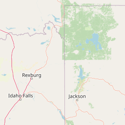
Map view of Red Rock Lakes Wilderness

Use this park location map to pinpoint Red Rock Lakes Wilderness in United States of America, understand its exact geographic position, and read its mapped placement within the surrounding landscape more clearly.

Pigeon | © OpenStreetMap contributors

Location context for Red Rock Lakes Wilderness

Beaverhead CountyMontana
Recorded earthquake history

Examine the Historical Earthquake Catalogue for Red Rock Lakes Wilderness

Gain insight into the seismic history of the region by browsing recorded event data for Red Rock Lakes Wilderness. This collection from MoriAtlas allows for a clear look at historical activity levels, magnitudes, and proximity to this wilderness landscape without incorporating predictive hazard analysis.

Red Rock Lakes Wilderness Earthquake History

Catalogued events

200 events

Strongest magnitude

Magnitude 5.2

Most recent event

Oct 3, 2025

This history includes earthquakes recorded inside the park or within 50 km of its borders

Visual exploration of high-elevation wetlands and protected mountain terrain

Red Rock Lakes Wilderness Photos and Landscape Scenery

Visual records capture the high-elevation wetlands, reflective lakes, and forested ridges that define the Red Rock Lakes Wilderness landscape. Examining protected-area photography reveals the remote terrain and wetland habitats supporting native wildlife across the Northern Rockies.

A wide, eye level landscape shot of a calm, reflective lake under a pale blue sky, with grassy marshes in the foreground and rounded, distant mountains across the horizon.

Park atlas

Compare adjacent wetland habitats, mountain ranges, and regional wildlife reserves.

Other Parks Near Red Rock Lakes Wilderness and Surrounding Protected Areas

Explore protected areas near Red Rock Lakes Wilderness to compare high-elevation wetland systems and mountain valley terrain. Examining adjacent regional reserves provides broader context on the ecological connectivity of the Northern Rockies.
Wildlife reserveMontana
22 km away#1 closest

North

Lee Metcalf Wilderness: Geographic Profile and Protected Landscape Boundaries in Montana

Mapping rugged alpine terrain across four distinct mountainous units

Located in southwestern Montana, the Lee Metcalf Wilderness serves as a cornerstone of ecological connectivity within the Greater Yellowstone Ecosystem. Spanning over 250,000 acres, this protected area features a unique fragmented geography consisting of the Bear Trap Canyon, Spanish Peaks, Taylor-Hilgard, and Monument Mountains units. The landscape is defined by its roadless mountain ridges, forested slopes, and deep river corridors, providing essential sanctuary for large mammal populations.

Area
1,029.07 km²
Established
1983
IUCN
Ib
Relief
Mountain
National parkWyoming
44 km away#2 closest

East

Yellowstone National Park: US National Park Protected Landscape & Geographic Atlas

Explore mapped boundaries and regional natural landscape context.

Yellowstone National Park represents a significant protected landscape within Wyoming, designated as a US national park. This entry offers detailed insight into its geographic scope, mapped boundaries, and the unique natural terrain that defines it. Understand its role in regional geography and discover its protected-area identity through a structured atlas exploration, providing context for its conservation landscape.

Area
8,983.18 km²
Established
1872
IUCN
II
Visitors
4.7M annual
Wildlife reserveWyoming
79 km away#3 closest

Southeast

Jedediah Smith Wilderness: Protected Alpine Terrain and Teton Range Geography

Glacially sculpted high-country basins in western Wyoming

Spanning the western face of the Teton Range, the Jedediah Smith Wilderness serves as a federally protected buffer for iconic mountain landscapes. The region features dramatic cirques, hanging valleys, and dense subalpine forest habitats, forming an essential, roadless link within the broader Greater Yellowstone Ecosystem. Explore the terrain features and structural geography that define this remote high-country wilderness area.

Area
499.59 km²
Established
1984
IUCN
Ib
Relief
Mountain
National parkUnited States of America
87 km away#4 closest

Southeast

Grand Teton National Park: Protected Landscape and Geographic Atlas Exploration

Explore the mapped terrain and regional park geography.

Grand Teton National Park is a protected landscape offering rich geographic discovery opportunities within the United States of America. This detailed entry facilitates an atlas-style exploration of its mapped boundaries, the surrounding regional geography, and its identity as a significant national park. Understand the specific landscape context and discover its placement within the broader natural terrain of North America.

Area
1,300 km²
Established
1929
IUCN
II
Visitors
2.8M annual
Soft watercolor illustration of a rolling mountain landscape with a forested foreground and faded, distant peaks.
Protected landscapeIdaho
90 km away#5 closest

West

Salmon, Challis National Forest: Geography and Protected Land Map in Central Idaho

Extensive alpine ridges and wild river corridors

Spanning over 4.2 million acres, Salmon, Challis National Forest is a foundational protected landscape in Idaho. This area includes the highest peaks in the state, such as Borah Peak, and holds the majority of the Frank Church, River of No Return Wilderness. Utilize this atlas resource to examine the intricate mountain topography, expansive river systems, and the contiguous wild corridors that define this significant portion of the northern Rockies.

Area
17,142.2 km²
Established
1908
Relief
Mountain
Climate
Temperate
Watercolor painting of a peaceful mountain valley landscape, showing a small winding stream in the foreground, grassy meadows, clusters of pine trees, and rolling mountain peaks in a soft, sunset-colored sky.
Protected landscapeWyoming
118 km away#6 closest

East

Shoshone National Forest: A Comprehensive Map and Geography of America's Oldest National Forest

Rugged wilderness and glacial peaks in Wyoming

Discover the immense geographic scale of Shoshone National Forest, which protects a diverse landscape ranging from sagebrush valleys to 13,000-foot granite summits. This atlas overview details its role within the Greater Yellowstone Ecosystem and its expansive, federally designated wilderness areas, offering a clear perspective on its volcanic and glacial terrain.

Area
9,992.69 km²
Established
1891
IUCN
VI
Visitors
500K annual
A watercolor painting depicting a soft, stylized mountain range and a river winding through a valley.
Protected landscapeMontana
164 km away#7 closest

North

Helena-Lewis and Clark National Forest: Geographic Overview and Protected Area Map

Montana wilderness spanning the Continental Divide

Spanning from the rolling eastern plains to the crest of the Northern Rockies, Helena-Lewis and Clark National Forest serves as a massive protected landscape in central Montana. This forest system protects eight unique mountain ranges and critical wilderness corridors, offering a comprehensive look at the ecological transition zones of the American Mountain West.

Area
11,000 km²
Established
1897
Relief
Mountain
Climate
Temperate
A soft watercolor painting of a mountain landscape with gentle green rolling hills, light green distant peaks, and scattered pink floral accents in the foreground against a white background.
Wildlife reserveIdaho
183 km away#8 closest

West

Jim McClure, Jerry Peak Wilderness: Geography and Protected Landscape Map in Idaho

Mapping central Idaho's remote mountain backcountry

Investigate the high-elevation wilderness geography of Jim McClure, Jerry Peak. This protected area in Custer County sits within the Salmon-Challis landscape, featuring a rugged mix of mountain peaks, dense coniferous forests, and remote drainages that define the character of the American West.

Area
473.07 km²
Established
2015
IUCN
Ib
Relief
Mountain

Common questions about visiting, size, designation, and location context for Red Rock Lakes Wilderness

Red Rock Lakes Wilderness FAQs for park facts, access, geography, and protected area context

Find quick answers about Red Rock Lakes Wilderness, including protected-area facts, park geography, trail and visitor context, and how the park fits into its surrounding country and regional landscape.
MoriAtlas Explorer

Continue Your Protected Areas Search Across the Global Atlas

Deepen your exploration by continuing the structured search for national parks and protected areas worldwide. Utilize the comprehensive filtering capabilities to compare different conservation landscapes and refine your understanding of global park geography. Discover more about the distribution and characteristics of protected natural areas.

Global natural geography