
Mori Atlas logo
Nature reserveReichenbacher Kalkberge

Explore the forest mosaics, limestone ridges, and protected habitats within the Geo-Naturpark Frau-Holle-Land

Reichenbacher Kalkberge Protected Area: A Geographic Survey of Limestone Landscapes in Germany

(Naturschutzgebiet und FFH-Gebiet Reichenbacher Kalkberge)

The Reichenbacher Kalkberge constitute a vital nature reserve in the Werra-Meißner-Kreis of northern Hesse, characterized by a complex intersection of Muschelkalk limestone geology and historic cultural land use. This protected area supports a dense mosaic of near-natural calcareous beech forests and sun-exposed orchid-rich grasslands. Through our geographic mapping, trace the transitions from the Kindelberg elevations down to the Weißbachtal valley, observing how protected terrain supports rare flora and fauna in a low-mountain context.

calcareous beech forestlime-rich semi-dry grasslandNatura 2000 siteFFH habitatlow-mountain landscapeMuschelkalk limestone
A flat, vector-style illustration of a serene mountain landscape featuring a tall waterfall cascading down high cliffs into a winding river, surrounded by lush evergreen trees, birch trees, and wildflowers in the foreground.

Reichenbacher Kalkberge

Nature reserve

Park overview

Structured park overview, official facts, and landscape profile for Reichenbacher Kalkberge

Reichenbacher Kalkberge park facts, protected area profile, and essential visitor context

Review the core facts for Reichenbacher Kalkberge, including designation, size, terrain, visitor scale, habitats, and operating context in one park-focused overview.

About Reichenbacher Kalkberge

The Reichenbacher Kalkberge occupy a compact group of hills just northwest of the village of Reichenbach, on the edge of the town of Hessisch Lichtenau in northern Hesse. Although modest in elevation, with summits between roughly 496 and 524 metres, they form a distinct limestone island within the broader Fulda-Werra-Bergland. The Weißbachtal separates the hills into a larger northwestern block, which includes the summit of Ruine Reichenbach (523 m) and the Großer Rohrberg (496 m), and a smaller northeastern block dominated by the Kindelberg (524 m). The geological substrate is Middle and Upper Muschelkalk, with bands of Upper Buntsandstein in the lower slopes, an unusual sequence in the region that gives the area both its limestone vegetation and its geoconservation value.

Ecologically, the reserve is defined by the contrast between shaded, beech-dominated slopes and open, sun-exposed ridge grasslands. The dominant forest type is the Waldmeister-Buchenwald (LRT 9130), accompanied by smaller stands of orchid-rich calcareous beech forest, beech forest on acidic soils, ravine and slope mixed forests, and floodplain forest along the streams. On the drier ridges, traditional sheep grazing once maintained large areas of Kalkmagerrasen, now a rare and highly protected habitat type known for orchids, gentians, and a specialist butterfly fauna. Between forest and grassland lie flower-rich lowland hay meadows, spring-fed flushes, and a small lake formed by historic lignite mining, adding further habitat diversity.

The cultural layer is unusually visible for a site of this size. The medieval Reichenbach castle ruin, with its tower repurposed as a viewpoint, sits at the heart of the forest reserve, and traces of historical coppice management (Niederwald) and former village flock husbandry are still readable in the vegetation. Today the Reichenbacher Kalkberge are both an active research site for forest dynamics and a well-known hiking destination, crossed by the Hessian premium trail P10, the Hessenweg 8, the Barbarossaweg X8, the Ars Natura art trail, and the Elisabethpfad 2.

Quick facts and research context for Reichenbacher Kalkberge

Located in the Gemarkungen of Hopfelde and Reichenbach, part of the town of Hessisch Lichtenau in the Werra-Meißner-Kreis, Hesse. Lies within the Geo-Naturpark Frau-Holle-Land as a northern outlier of the Stölzinger Gebirge, assigned to the Hessisch-Lichtenauer Becken within the Fulda-Werra-Bergland. Declared a Naturschutzgebiet in 1996 by the Regierungspräsidium Kassel and confirmed as a Natura 2000 (FFH) site in 2008 under Hessian law, covering an enlarged area of 383.47 hectares compared with the original 150.25-hectare nature reserve. Contains the 66.6-hectare Naturwaldreservat around the Ruine Reichenbach, one of about 31 such forest research reserves across Hesse.

Protection and recognition

Documented terrestrial designation history, management scope, and Natura 2000 records

Reichenbacher Kalkberge Protection Status and International Recognition

Reichenbacher Kalkberge maintains a recorded terrestrial protection status established in 2008 alongside verified Natura 2000 recognition sources. Official designation history and international records provide structured insight into the protected area framework.

International recognition

Protection details

Protection scope
Terrestrial
Designated year
2008
Transboundary protection
No
WDPA ID
165129
Park context

Deeper park guide and search-rich context for Reichenbacher Kalkberge

Reichenbacher Kalkberge history, landscape, wildlife, and travel context

Explore Reichenbacher Kalkberge through its history, landscape character, ecosystems, wildlife, conservation priorities, cultural context, and seasonal travel timing in a structured park guide built for atlas discovery and search intent.

Why Reichenbacher Kalkberge stands out

The reserve is best known for its near-natural calcareous beech forest on Muschelkalk, especially the large Waldmeister-Buchenwald stands that form the ecological core. It is equally valued for its orchid-rich lime-rich semi-dry grasslands on the Kindelberg and Großer Rohrberg, which host a remarkable diversity of butterflies, wild orchids, and rare plants such as the Großes Windröschen. The combination of an EU-protected FFH site, a Hessian Naturschutzgebiet, and a strict-process Naturwaldreservat around a medieval castle ruin gives the area a layered conservation identity that is unusual for a small low-mountain range.
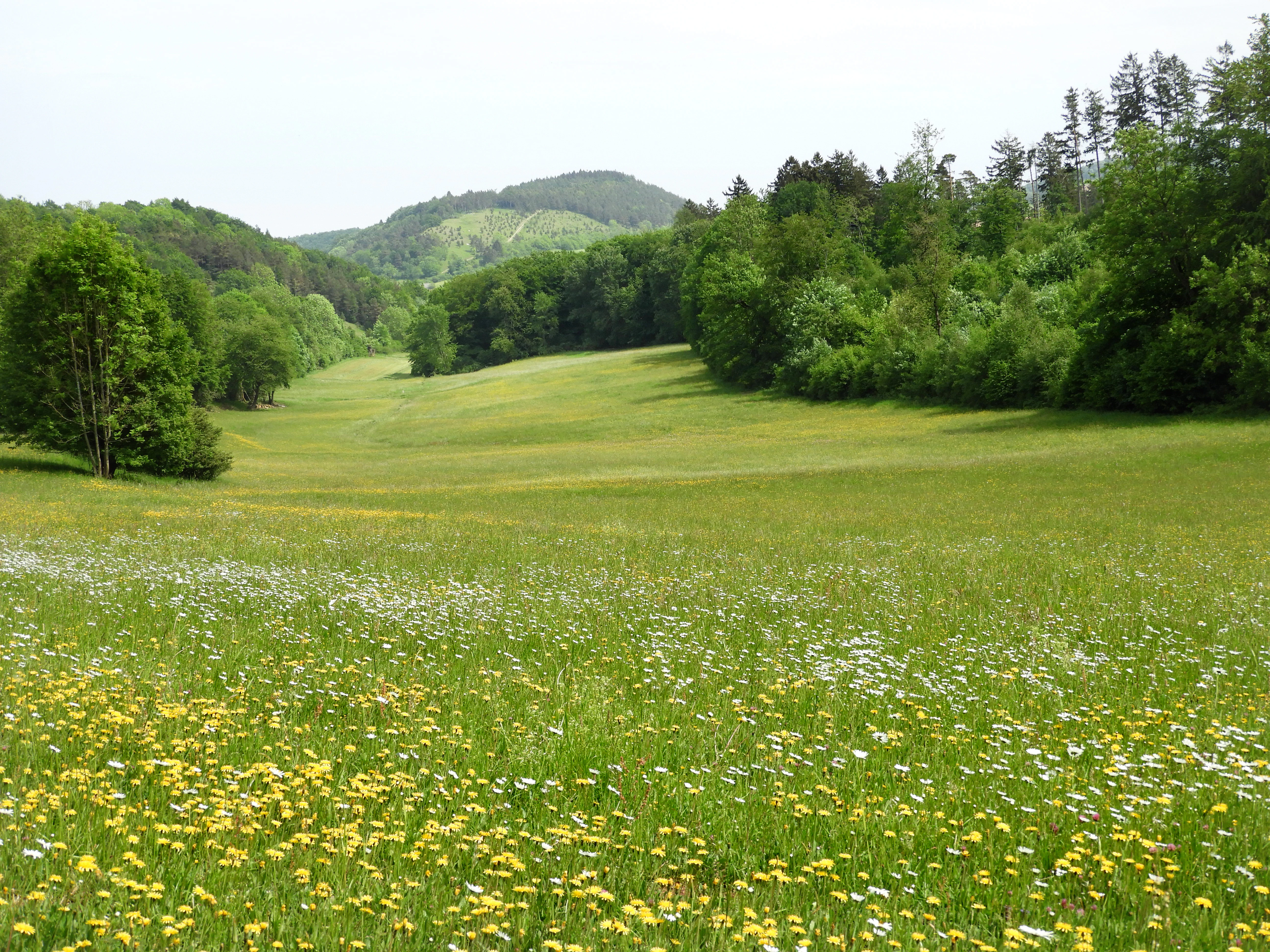
A wide, grassy meadow filled with wildflowers under a hazy sky, bordered by dense deciduous forests and hills in the distance.
A scenic view of a meadow within the Reichenbacher Kalkberge nature reserve, with forested hills in the background.

Reichenbacher Kalkberge history and protected-area timeline

The conservation history of the Reichenbacher Kalkberge began in the late twentieth century, when growing awareness of the area's rare calcareous habitats prompted formal protection. On 10 December 1996 the Regierungspräsidium Kassel, acting as the higher nature conservation authority for the region, issued a decree establishing the Reichenbacher Kalkberge as a Naturschutzgebiet. The stated purpose was to secure species-rich deciduous forest, allow natural forest dynamics to increase deadwood as habitat for cavity-nesting birds and insects, protect the rare lime-rich grasslands and spring mires, and convert adjacent farmland into species-rich meadow and pasture.

In 2004 the Hessian nature conservation administration completed the reporting procedure under the EU Birds Directive and the Fauna-Flora-Habitat Directive, formally proposing the area to the European Commission as part of the transboundary Natura 2000 network. Following this, the Hessian "Verordnung über Natura 2000-Gebiete" of January 2008 legally fixed conservation objectives and boundaries at the state level, creating FFH site 4824-301. Compared with the original nature reserve, the Natura 2000 area was expanded to 383.47 hectares through the addition of the Hellkopf, Mittelberg, Silberküppel, and Sommerberg areas. A baseline habitat and species survey (Grunddatenerfassung) for the FFH site was finalized in March 2009.

Alongside these designations, a dedicated Naturwaldreservat was established around the Burg Reichenbach as part of the Hessian natural forest reserve programme initiated in 1988. By the time of its designation the Reichenbacher reserve became one of about 31 such sites distributed across Hesse, set up to document natural forest dynamics under strict process protection on a Totalreservat alongside a comparable, still-managed Vergleichsfläche. Botanical, zoological, and forest-structural monitoring is coordinated by the Nordwestdeutsche Forstliche Versuchsanstalt from Göttingen and Hann. Münden.

Reichenbacher Kalkberge landscape and geographic character

The landscape of the Reichenbacher Kalkberge is shaped above all by limestone geology. Middle and Upper Muschelkalk form steep, often dramatically sloping hillsides, while the lower slopes transition into Upper Buntsandstein. The hills sit as a northern outlier of the Mittelgebirge Stölzinger Gebirge and fall within the Hessisch-Lichtenauer Becken of the Fulda-Werra-Bergland, which is part of the broader Osthessisches Bergland.

Topographically the area is split by the Weißbachtal into two blocks. The larger western block comprises the castle hill of Ruine Reichenbach at 523 m and the Großer Rohrberg at 496 m, while the smaller eastern block is dominated by the Kindelberg at 524 m, the reserve's highest point. Elevation across the protected area ranges from about 370 m to 524 m. The slopes are mostly forested and steep, but along the ridges the terrain opens into dry, shallow-soil grasslands whose exposure and thin substrates make them distinctive against the surrounding wooded low-mountain landscape. The reserve is part of the larger Geo-Naturpark Frau-Holle-Land, which integrates this geological and cultural character into a regional geotourism framework. To the north, the silhouette of the landscape is further marked by a small lake and reclaimed brown-coal mining heaps from seventeenth-century activity on the Kuhkoppe.
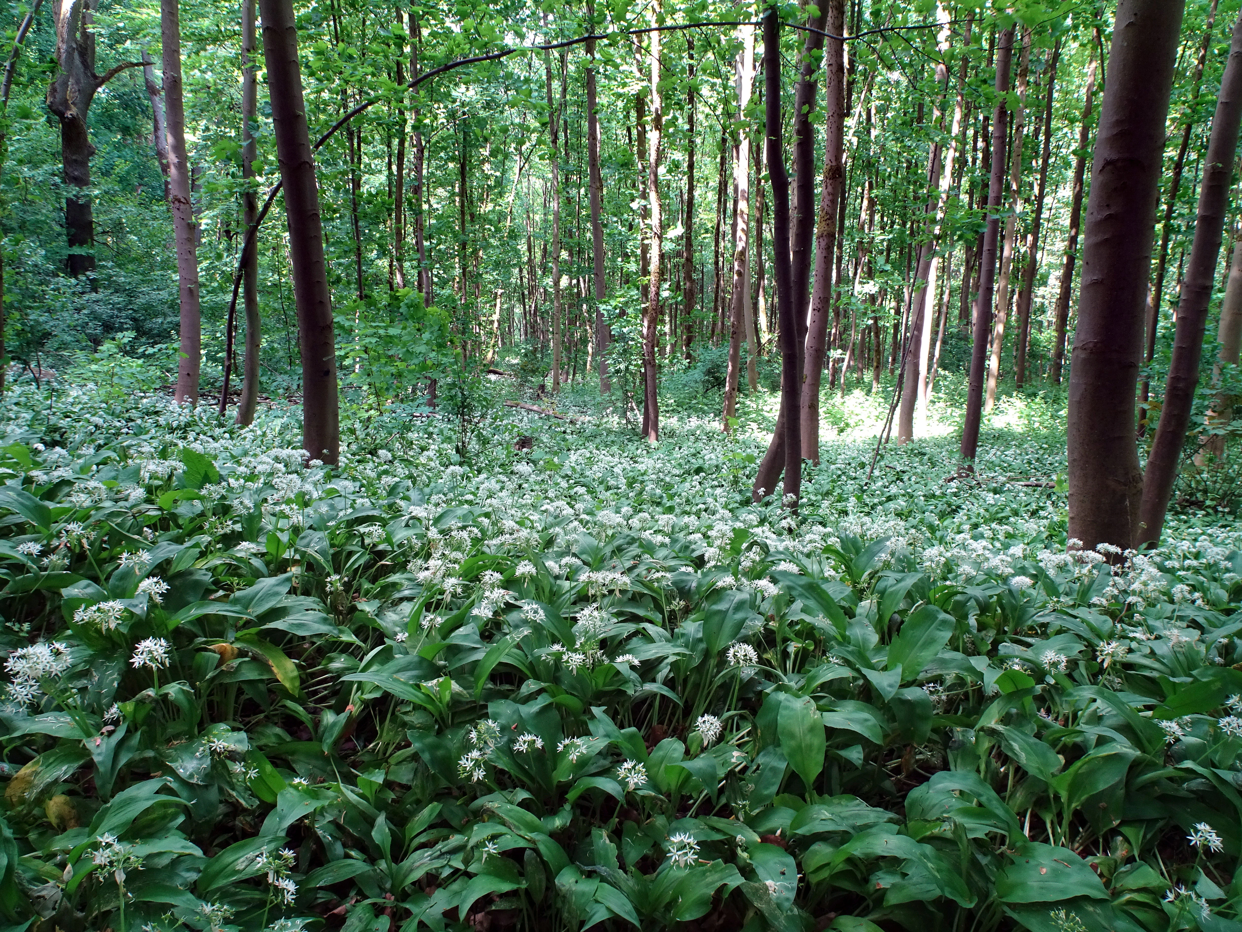
A wide view of a forest floor covered in a thick carpet of white wild garlic blossoms and green leaves, interspersed with tall, thin beech tree trunks.
A dense carpet of blooming wild garlic in the beech forests of Reichenbacher Kalkberge.

Reichenbacher Kalkberge ecosystems, habitats, and plant life

Ecologically, the Reichenbacher Kalkberge are a textbook example of a calcareous mosaic in a low-mountain setting, where forest, grassland, mire, and aquatic habitats are tightly interwoven. The Natura 2000 survey recorded eleven habitat types, five of them considered priority because they are threatened and carry particular conservation responsibility. The Waldmeister-Buchenwald on Muschelkalk is the absolute core, complemented by smaller patches of orchid-rich calcareous beech forest, acidic beech forest with Luzula, ravine and slope mixed forests, and small stands of hardwood floodplain forest along the streams.

Open habitats add a second tier of conservation value. Extensive lime-rich semi-dry grasslands on the Kindelberg and Großer Rohrberg, which scientists classify as Gentiana-Stipa grassland, host an exceptionally rich flora including common gentians, clustered bellflower, gold thistle, and protected species such as the Großes Windröschen (anemone) and Sumpf-Kreuzblume. Around 22 hectares of lowland hay meadows belong to the classic Glatthaferwiesen type, a flower-rich, nutrient-poor meadow community now rare across Germany. Small specialized features include a calcareous tufa spring, a calcareous scree slope, a naturally eutrophic lake, and a calcareous lowland mire, each contributing a distinct microhabitat.

The flora is closely tied to centuries of land use. Traces of historical coppice woodland (Niederwald), once used for firewood, are still visible in old forest stands, while sheep and goat grazing on the steep slopes shaped the modern grasslands. Continued abandonment without grazing or scrub clearance would progressively convert the open grasslands back into scrub and forest, so active management, including extensive sheep pasturing and selective clearing, is now part of the conservation strategy.
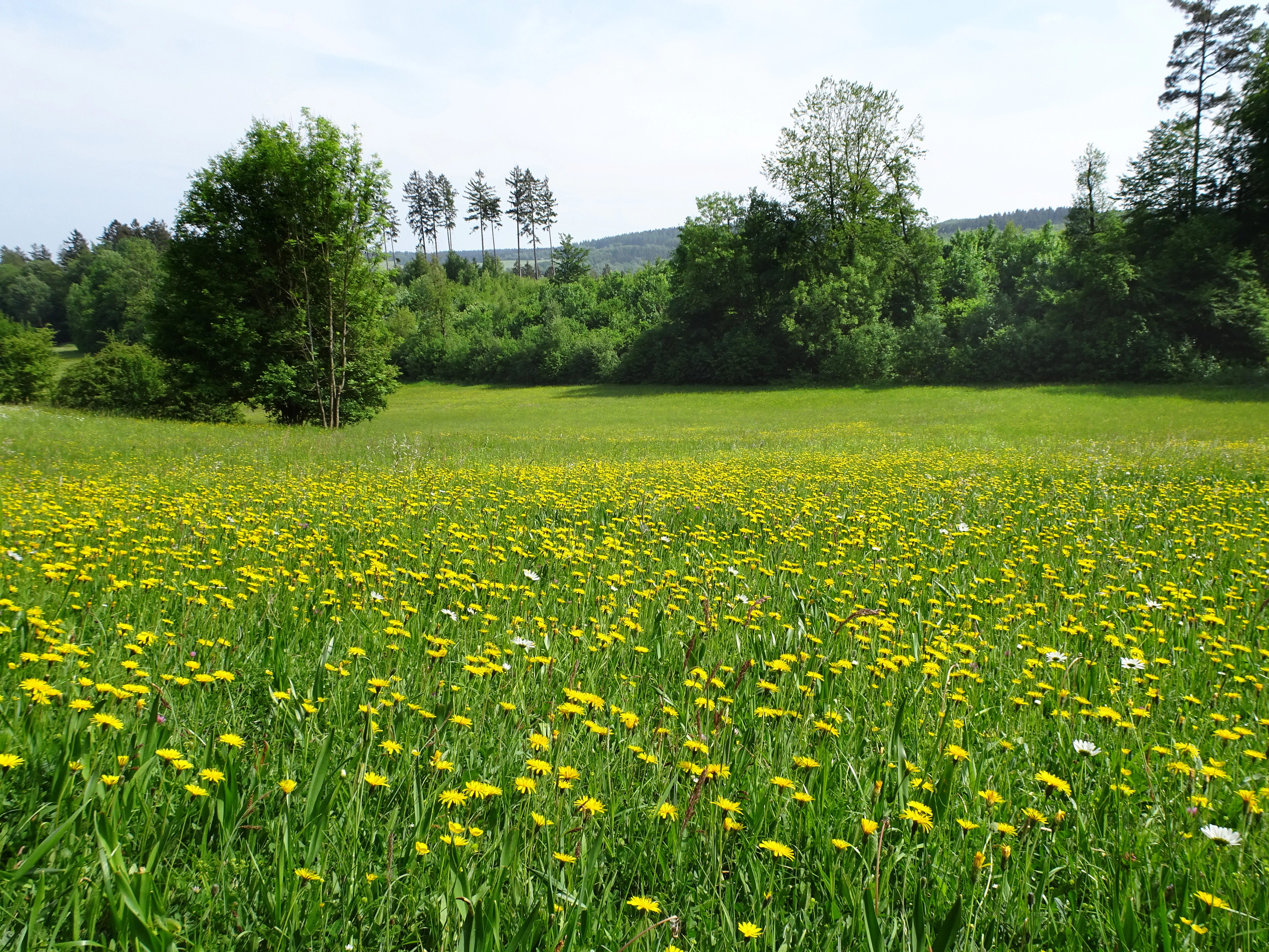
A wide, grassy meadow covered in yellow wildflowers, with a dense forest line and low hills in the background under a soft, overcast sky.
A meadow in bloom within the Reichenbacher Kalkberge nature reserve.

Reichenbacher Kalkberge wildlife and species highlights

The reserve is significant for both specialist invertebrates and larger mammals. The semi-dry grasslands support a particularly rich butterfly fauna documented in the early 2000s surveys, including threatened species such as the Komma-Dickkopffalter, Kronwicken-Dickkopffalter, Roter Würfel-Dickkopffalter, Goldene Acht, Großer Perlmuttfalter, Kreuzdorn-Zipfelfalter, and Zwerg-Bläuling, along with several burnet moths and the rare Rundaugen-Mohrenfalter, Graubindiger Mohrenfalter, and Brauner Feuerfalter along the woodland edges. Among grasshoppers, the strongly threatened Rotflüglige Schnarrschrecke and Schwarzfleckiger Grashüpfer are considered notable fauna records. The small former-mining lake adds a dragonfly component, including the in Hesse endangered Große Granatauge.

Forest wildlife is shaped by mature and old-growth beech with substantial deadwood. The Bechsteinfledermaus and the Große Mausohr use the area as foraging habitat, and at least eight further bat species find suitable roosting and hunting territory among the hills. The Wildkatze (European wildcat) is also present. Mammals of particularly high conservation profile include the Luchs (lynx), recorded as an Annex II species. Breeding and foraging birdlife is rich, with Neuntöter, Grauspecht, Schwarzspecht, Schwarzstorch, Rotmilan, Hohltaube, and Waldschnepfe all noted as value-defining species under the Birds Directive. Among scarce plants, the orchid Frauenschuh, the butterfly Dunkler Wiesenknopf-Ameisenbläuling, and notable orchid community on the grasslands give the area a particular botanical-fawnal significance.

Reichenbacher Kalkberge conservation status and protection priorities

The conservation importance of the Reichenbacher Kalkberge rests on three concentric layers of protection. The 1996 Naturschutzgebiet designation by the Regierungspräsidium Kassel created a frame for securing deciduous forest, allowing natural dynamics such as deadwood accumulation, protecting rare lime-rich grasslands and spring mires, and improving adjacent farmland for meadow species. The 2008 designation as a Natura 2000 site under the EU Habitats Directive then elevated several habitats and species to pan-European importance, including the priority orchid-rich calcareous grassland, calcareous scree, tufa spring, and ravine forest types.

The Naturwaldreservat around Burg Reichenbach adds a third, research-driven dimension. Its strict Totalreservat excludes any forestry intervention, while a neighbouring Vergleichsfläche is still managed close to nature, allowing direct comparison between protected and lightly used forest. Across all three layers the site is monitored for habitat types, bats, wildcats, lynx, orchids, butterflies, and forest structure, with formal baseline data collection completed in 2009. Active measures including scrub removal and extensive sheep grazing are used to keep the semi-dry grasslands from being lost to bush encroachment. The integration of process protection, EU-level habitat conservation, and cultural landscape management in a single, relatively compact site makes the reserve an unusually complete example of modern German conservation practice in a low-mountain setting.

Reichenbacher Kalkberge cultural meaning and human context

The Kalkberge carry an unusually rich cultural imprint for a small natural area. Centuries of grazing by village flocks, including the historic flock of the Reichenbach Kirchengut, created the grasslands that today are among the most species-rich habitats in the reserve; the End of traditional shepherding in the 1920s is directly felt in the vegetation as scattered pine stands and ongoing scrub encroachment. Forest history is equally visible in surviving traces of the Niederwald coppice system that once supplied fuelwood, leaving a structural legacy in older woodland stands.

At the centre of the reserve stands the Burg Reichenbach, a medieval castle ruin whose bergfried now serves as a viewing tower. Although the castle brings high recreational use that creates some tension with the strict process-protection goals of the Naturwaldreservat, it also anchors the site as a cultural landscape feature. The wider region around the Geo-Naturpark Frau-Holle-Land ties this heritage into a broader narrative of Hessian low-mountain cultural landscape, and the area is embedded in long-distance trails such as the Barbarossaweg, the Ars Natura art trail, and the Elisabethpfad, which combine pilgrimage, art, and dynastic history with the natural environment.

Top sights and standout views in Reichenbacher Kalkberge

Highlights of the Reichenbacher Kalkberge include the orchid-rich limestone grasslands of the Kindelberg and Großer Rohrberg, with the rare Großes Windröschen population; the dominant Galio odorati-Fagetum beech forest on Muschelkalk that forms the ecological backbone of the reserve; the Naturwaldreservat around Burg Reichenbach with its strict Totalreservat and adjacent comparison forest; the medieval Reichenbach castle ruin and its repurposed bergfried viewpoint; the small calcareous tufa spring and the calcareous scree habitat, both priority types under the EU Habitats Directive; and the network of flower-rich lowland hay meadows with red-list butterflies such as the Roter Würfel-Dickkopffalter and the Goldene Acht. The site is also one of relatively few places in Hesse where eleven distinct FFH habitat types meet within a single protected landscape.

Best time to visit Reichenbacher Kalkberge

Late spring through early summer is generally the most rewarding time to experience the Reichenbacher Kalkberge. In May the lowland hay meadows are at their floristic peak, the Bärlauch carries a strong white bloom in the beech forests around the Burgberg, and early orchid species begin to appear on the warmer limestone slopes. Through June and into July the orchid-rich Magerrasen on the Kindelberg and Großer Rohrberg reach their richest display, accompanied by strong butterfly activity. Late summer and early autumn bring quieter conditions, softer light, and clearer views from the castle ruin across the wooded hills, while the beech forests themselves take on colour as the season turns. Winter visits are also possible, but the beech foliage largely obscures distant views and the grasslands are less expressive.

Monthly climate preview

Long-term monthly temperature and precipitation patterns across the protected landscape

Reichenbacher Kalkberge Climate Normals and Annual Temperature Rhythm

Reichenbacher Kalkberge exhibits a measured annual temperature and precipitation rhythm derived from long-term representative coordinate climatology. The complete monthly profile reveals detailed fluctuations in average maximum and minimum values across the entire seasonal cycle.
Annual mean8 °C
-1 °C18 °C
Jan-1°
Feb
Mar
Apr
May12°
Jun16°
Jul18°
Aug18°
Sep14°
Oct
Nov
Dec
Warmest month
July

18.3 °C

Coolest month
January

-1.1 °C

Wettest month
July

2.6 mm/day

Driest month
April

1.4 mm/day

Park location guide

Geography guide, regional context, and park location map for Reichenbacher Kalkberge

Reichenbacher Kalkberge park geography, regions, and map view in Germany

Understand where Reichenbacher Kalkberge sits in Germany through a broader geographic reading of the surrounding landscape, nearby location context, and its mapped position within the national park landscape.

How Reichenbacher Kalkberge fits into Germany

Germany is a federal republic in Western and Central Europe with a population of over 83 million across sixteen constituent states. It is Europe's largest economy by nominal GDP and a major global exporter and importer. The capital is Berlin, and the country borders Denmark, Poland, Czech Republic, Austria, Switzerland, France, Luxembourg, Belgium, and the Netherlands.

Wider geography shaping Reichenbacher Kalkberge in Germany

Germany is located in Western and Central Europe, spanning 357,022 km². It borders Denmark to the north, Poland and the Czech Republic to the east, Austria and Switzerland to the south, and France, Luxembourg, Belgium, and the Netherlands to the west. The country has coastlines on the Baltic Sea and North Sea to the north, with the Alps located in the southern region.

Map view of Reichenbacher Kalkberge

Use this park location map to pinpoint Reichenbacher Kalkberge in Germany, understand its exact geographic position, and read its mapped placement within the surrounding landscape more clearly.

Pigeon | © OpenStreetMap contributors

Location context for Reichenbacher Kalkberge

Werra-Meißner-Kreis
Recorded earthquake history

Explore the Historical Earthquake Catalogue for Reichenbacher Kalkberge

Access a structured collection of recorded seismic events mapped to the surroundings of the Reichenbacher Kalkberge. This resource provides insight into regional earthquake activity through objective data, allowing for deeper exploration of the geographical environment within the Werra-Meißner-Kreis.

Reichenbacher Kalkberge Earthquake History

Catalogued events

2 events

Strongest magnitude

Magnitude 3.2

Most recent event

Sep 22, 2005

This history includes earthquakes recorded inside the park or within 50 km of its borders

Visual reference of limestone ridges, calcareous beech forests, and rare grassland habitats

Reichenbacher Kalkberge Photos and Mapped Protected Area Scenery

Visual documentation captures the steep Muschelkalk limestone slopes, shaded beech forests, and exposed semi-dry grasslands that define the protected landscape. Examining these field photographs reveals the varied terrain and rare habitat mosaic found across the northern Hesse reserve.

A wide, grassy meadow filled with wildflowers under a hazy sky, bordered by dense deciduous forests and hills in the distance.

A scenic view of a forested valley in autumn with vibrant yellow, orange, and green trees under a clear sky.

A wide view of a forest floor covered in a thick carpet of white wild garlic blossoms and green leaves, interspersed with tall, thin beech tree trunks.

A wide, grassy meadow covered in yellow wildflowers, with a dense forest line and low hills in the background under a soft, overcast sky.

Park atlas

Explore surrounding low mountain terrain, limestone reserves, and regional conservation areas.

Parks Near Reichenbacher Kalkberge and Connected Protected Landscapes

Compare Reichenbacher Kalkberge with adjacent protected landscapes and forested low mountain reserves across northern Hesse. Discovering related regional parks provides deeper context on local limestone geology and rare calcareous habitats.
Watercolor painting of a mountain landscape with green slopes, coniferous forests, and rocky outcroppings under a soft, light-filled sky.
Nature reserveHesse
1 km away#1 closest

Northeast

Meißner Nature Reserve in Northern Hesse: Mapping the Hoher Meißner Basaltic Massif

A comprehensive look at forest wilderness, bogs, and volcanic geology

Covering roughly 930 hectares, the Meißner nature reserve in northern Hesse protects an ecologically distinct upland landscape. The area features a significant basalt plateau, ancient scree slopes, mountain meadows, and hanging spring bogs, offering a prime example of protected central German topography and forest wilderness.

Area
9.322 km²
Established
1989
IUCN
IV
Relief
Mountain
A watercolor painting showing a soft, green landscape with gentle rolling hills, small clusters of trees, and a small meandering stream, framed by delicate wild flowers in the foreground.
Nature reserveWerra-Meißner-Kreis
About 4.9 km away#2 closest

Northeast

Quellgebiet der Weißen Gelster: Nature Reserve Geography and Protected Area Mapping

Calcareous spring mires and wet meadows in Werra-Meißner-Kreis

Located at the foot of the Meinetsberg, Quellgebiet der Weißen Gelster features a series of groundwater-dependent habitats including Davall's sedge fens and golden oat meadows. The reserve represents a key segment of the regional protected-area network, preserving rare vegetation types on Keuper bedrock within a characteristic upland agricultural valley.

Area
0.115 km²
Established
1991
IUCN
IV
Relief
Upland
A soft, light-colored watercolor painting of a rolling hilly landscape with sparse trees and open grassy meadows.
Nature reserveWerra-Meißner-Kreis
About 8.4 km away#3 closest

Northeast

Bühlchen bei Weißenbach Nature Reserve: Protected Limestone Grasslands in Werra-Meißner-Kreis

Geographic atlas of a historic juniper heath and limestone hilltop.

Bühlchen bei Weißenbach represents a rare, semi-open cultural landscape shaped by centuries of sheep grazing on shell limestone summits. This nature reserve, integrated into the Natura 2000 network, offers a dense concentration of rare orchids and gentians across its rocky, nutrient-poor slopes, serving as a critical site for regional ecological study and landscape preservation.

Area
0.08 km²
Established
1985
IUCN
IV
Relief
Mountain
A horizontal watercolor painting showing a soft, muted landscape with rolling hills, a central open area, and clusters of green trees under a pale sky.
Nature reserveWerra-Meißner-Kreis
About 10 km away#4 closest

Northeast

Kripp- und Hielöcher Nature Reserve: Karst Geography and Protected Land in Werra-Meißner-Kreis

Geology-focused nature reserve featuring gypsum sinkholes and dry grasslands.

Kripp- und Hielöcher provides a rare look at Zechstein gypsum karst in Hesse. The reserve is split into two distinct areas, the Kripplöcher and Hielöcher, showcasing natural rock monuments, active karst springs, and a historical cultural landscape maintained through centuries of traditional land use.

Area
0.17 km²
Relief
Upland
Climate
Temperate
Access
Moderate access
A soft, minimalist watercolor painting of rolling hills and trees set against a white background.
Nature reserveHessen
12 km away#5 closest

Northeast

Bilstein im Höllental: Protected Diabase Cliff and Ravine Forest in Hessen

Geological landscape and Natura 2000 protected area

Discover the geographic significance of Bilstein im Höllental, a nature reserve in the Werra-Meißner-Kreis that showcases a rare juxtaposition of warm rock refuges and cool, shaded ravine environments. The reserve protects significant cliff-dwelling plant communities and traces of medieval history upon its 284-meter diabase summit, providing a focused example of geological resistance shaping valley terrain.

Area
0.032 km²
Established
1960
IUCN
IV
Relief
Mountain
A wide watercolor illustration of a rolling landscape with green fields, patches of pink flowers, and distant purple hills under a pale sky.
Nature reserveWerra-Meißner-Kreis
About 14 km away#6 closest

East

Jestädter Weinberg: Protected Zechstein Cliffs and Werra River Valley Mosaic

A botanical and geological hotspot in northern Hesse

Jestädter Weinberg represents a critical protected landscape defined by its steep dolomite rock faces and sun-exposed slopes. This nature reserve provides an essential habitat for orchids and diverse insect populations, bridging the gap between high-altitude limestone ridges and the riparian meadows of the Werra river valley.

Area
0.6 km²
Established
1924
IUCN
IV
Relief
Upland
A horizontal watercolor illustration depicting rolling green hills, scattered trees, and soft mountain silhouettes against a pale sky.
Protected areaGermany
15 km away#7 closest

North

Kalkmagerrasen bei Roßbach: Protected Calcareous Grassland and Juniper Landscape in Germany

Geographic atlas and protected area overview in Hesse

Kalkmagerrasen bei Roßbach consists of five distinct plots that protect rare Enzian Schillergras Rasen communities on shallow Zechstein limestone soils. This site remains a critical stronghold for diverse orchid populations and protected butterfly species within the Werra Meißner region. The mosaic of juniper, flowering herbs, and historic cherry orchards creates a unique Mediterranean character rarely found in central German hill country.

Area
0.551 km²
Established
1996
Relief
Upland
Climate
Temperate
A soft, panoramic watercolor painting depicting a green floodplain with a winding river, scattered trees, and rolling hills in the distance.
Nature reserveSchwalm-Eder-Kreis
15 km away#8 closest

Southwest

Fuldatal bei Konnefeld: Protected Floodplain and Wetland Geography in Schwalm-Eder-Kreis

An essential river valley habitat and nature reserve in northern Hesse

Fuldatal bei Konnefeld is a compact, high-value nature reserve situated along the Fulda river valley. The landscape is defined by its old river oxbows, soft-wood forest galleries, and species-rich hay meadows. This resource provides a focused geographic overview of its protected status as a Natura 2000 site and its function as a vital wildlife corridor.

Area
0.169 km²
Established
1989
IUCN
IV
Relief
Lowland

Common questions about visiting, size, designation, and location context for Reichenbacher Kalkberge

Reichenbacher Kalkberge FAQs for park facts, access, geography, and protected area context

Find quick answers about Reichenbacher Kalkberge, including protected-area facts, park geography, trail and visitor context, and how the park fits into its surrounding country and regional landscape.
MoriAtlas Explorer

Continue Your Protected Areas Search Across the Global Atlas

Deepen your exploration by continuing the structured search for national parks and protected areas worldwide. Utilize the comprehensive filtering capabilities to compare different conservation landscapes and refine your understanding of global park geography. Discover more about the distribution and characteristics of protected natural areas.

Global natural geography