
Mori Atlas logo
Nature reserveReifenberger Wiesen

Analyzing the ecological terrain and geographic boundaries of upland nutrient-poor meadow systems.

Reifenberger Wiesen Nature Reserve: Mapped Protected Landscapes in the High Taunus Mountains

(Naturschutzgebiet Reifenberger Wiesen)

Reifenberger Wiesen represents a vital protected landscape situated on the northern slopes of the Großer Feldberg within the Hochtaunuskreis region of Hesse. This nature reserve, characterized by its high-altitude nutrient-poor hay meadows and mountain pastures, sits at elevations between 650 and 700 meters. The area serves as a significant botanical habitat for rare species and functions as a managed cultural landscape, bridging the forest margin and local highland settlements.

nature reservemeadowsnutrient-poor grasslandmagere WiesenTaunusHochtaunuskreis
A flat-style digital illustration showing a flowery meadow in the foreground with trees on the sides, leading to a waterfall cascading down a cliff face with distant mountains in the background under a pale sun.

Reifenberger Wiesen

Nature reserve

Park overview

Structured park overview, official facts, and landscape profile for Reifenberger Wiesen

Reifenberger Wiesen park facts, protected area profile, and essential visitor context

Review the core facts for Reifenberger Wiesen, including designation, size, terrain, visitor scale, habitats, and operating context in one park-focused overview.

About Reifenberger Wiesen

Reifenberger Wiesen occupies a north-facing slope of the Großer Feldberg, the highest mountain in the Taunus range, lying between the small Hochtaunus villages of Oberreifenberg and Niederreifenberg. The reserve sits at high elevation, roughly between 650 and 700 meters above sea level, and covers about 23 hectares of sloping terrain whose openness contrasts with the surrounding wooded slopes of the Taunus.

The site is a classic example of a German Naturschutzgebiet that protects not untouched wilderness but a culturally shaped landscape of high ecological value. The meadows originated from the grazing needs of the historic Feldberg villages, whose inhabitants cleared and maintained the few areas where agriculture was even possible at this elevation and gradient. Over generations, this traditional land use created open grassland communities on thin, low-nutrient soils. After the Second World War, agricultural mechanization made these marginal plots uneconomical, and many fields were abandoned. The vegetation that subsequently developed, freed from intensive management but still shaped by past use, became a refuge for plants and animals adapted to species-rich meadow habitat.

Today Reifenberger Wiesen is both a designated Naturschutzgebiet under Hessian law (since 1983) and a protected FFH area within the European Natura 2000 network. It is closely associated with the Weil river, whose headwaters rise only a few hundred meters above the reserve near the small Roman fort of Kastell Kleiner Feldberg. The boundary of the reserve is marked by cultural and infrastructural features as much as by natural ones, bordered uphill by the Limesstraße, downhill by the edge of village development (including the former Bildungs- und Familienstätte Oberreifenberg), and laterally by road and forest edge.

The area is bounded nearby by the youth hostel of Oberreifenberg and the Naturparkhotel Weilquelle, and the so-called Heimliche Wiese within the reserve is used as a winter ski piste. This proximity to tourism infrastructure makes Reifenberger Wiesen a site where conservation, local recreation, and ecological awareness coexist, regularly visited by hikers exploring the slopes of the Großer Feldberg.

Quick facts and research context for Reifenberger Wiesen

Reifenberger Wiesen is a protected nature reserve in the Hochtaunuskreis district of Hesse, situated on the north-facing slope beneath the Großer Feldberg, the highest peak in the Taunus range. It was established as a Naturschutzgebiet in 1983 and forms part of the EU Natura 2000 network as an FFH area. The landscape consists of nutrient-poor, semi-natural meadows shaped by traditional grazing, traversed by the Weil river, which rises nearby.

Park context

Deeper park guide and search-rich context for Reifenberger Wiesen

Reifenberger Wiesen history, landscape, wildlife, and travel context

Explore Reifenberger Wiesen through its history, landscape character, ecosystems, wildlife, conservation priorities, cultural context, and seasonal travel timing in a structured park guide built for atlas discovery and search intent.

Why Reifenberger Wiesen stands out

Reifenberger Wiesen is best known for its species-rich, nutrient-poor hillside meadows that host a notable concentration of specialized plants, including the very rare Lanzettblättrige Glockenblume (lance-leaved bellflower), whose main distribution in the Taunus lies here. The reserve illustrates how centuries of marginal mountain grazing produced a delicate botanical diversity that would otherwise be lost to woodland encroachment.
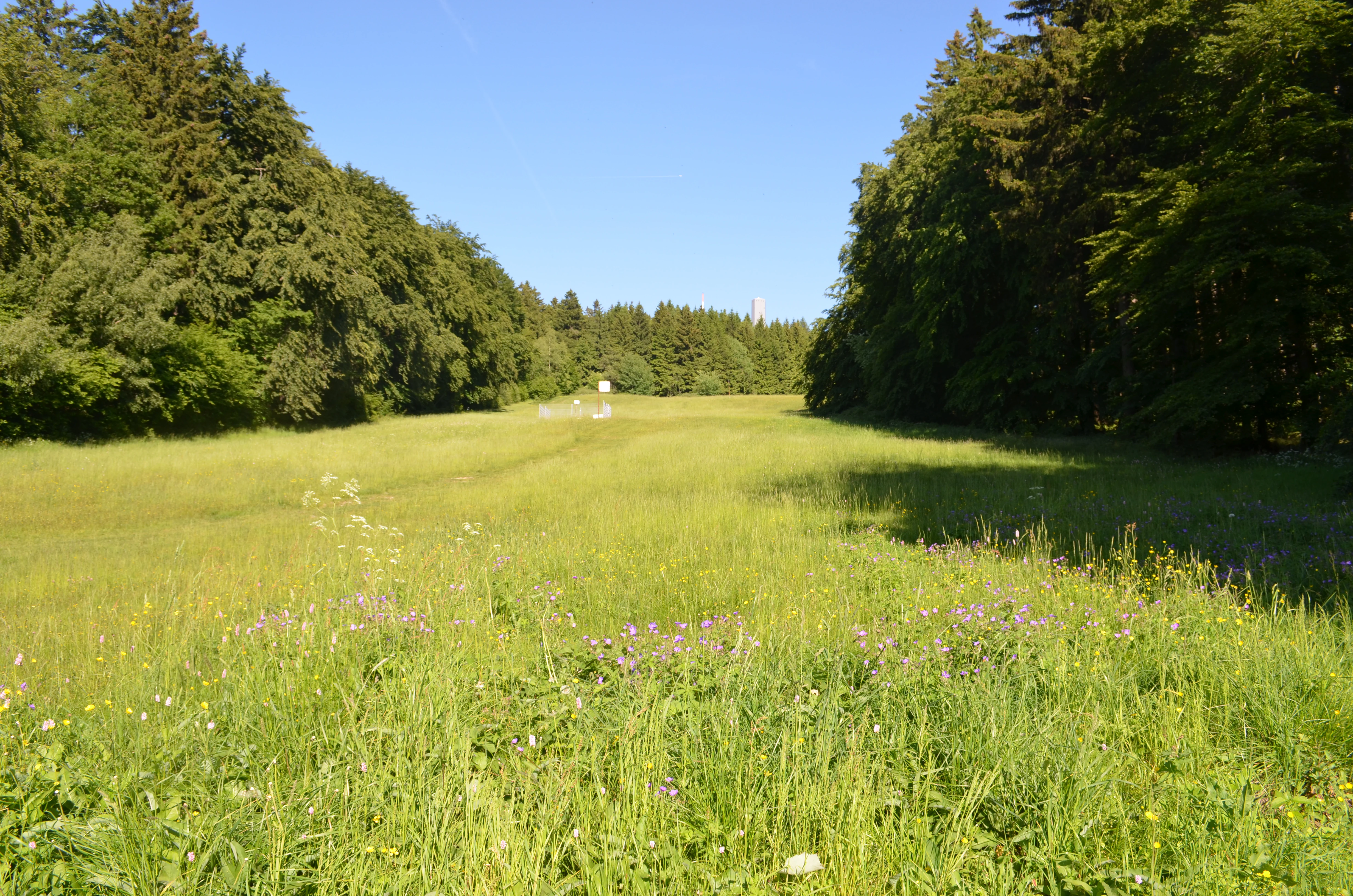
A wide, grassy meadow stretches between two dense walls of forest under a clear blue sky.
A meadow in the Reifenberger Wiesen nature reserve, surrounded by dense forest.

Reifenberger Wiesen history and protected-area timeline

The landscape of Reifenberger Wiesen is the product of centuries of rural land use in an unusually demanding mountain environment. The villages around the Feldberg were historically very poor, and their residents cultivated the few relatively accessible slopes where farming was even possible. On the steep, high-elevation terrain of what is now the reserve, only grazing was viable, and through repeated clearing and ongoing pasturing, open meadows were maintained.

In the twentieth century, the character of this land use changed dramatically. After the Second World War, the mechanization of agriculture made continued extensive grazing on marginal sites like the Reifenberger Wiesen economically unviable. Fields were abandoned, and the meadows began developing largely on their own, producing a botanical diversity that conservationists soon recognized as worthy of protection. The area was formally designated as a Naturschutzgebiet on 17 October 1983, securing its legal protection under Hessian nature conservation law.

In subsequent decades, the site was also recognized at the European level as FFH-Gebiet 5716-304, integrating it into the Natura 2000 network and tying its management to EU habitat conservation obligations. By the early 2010s, conservation managers faced the visible reality that, although abandonment had initially benefited species diversity, continued lack of intervention would allow shrubs and trees to reclaim the slopes. In early 2012, a partial area of 10 hectares was cleared to counteract this encroachment and preserve the open meadow character on which the reserve's most specialized species depend.

Reifenberger Wiesen landscape and geographic character

Reifenberger Wiesen is defined by its position on the north-facing slope of the Großer Feldberg and by the clear contrast between the open meadows within the reserve and the surrounding forested highland. The terrain is a pronounced hillside, inclined from higher elevations at the uphill boundary under the summit ridge of the Feldberg down toward the valley. Elevations within the reserve lie roughly between 650 and 700 meters, giving the meadows an upland feel even within the relatively low Taunus range.

The boundaries of the site are shaped as much by human infrastructure as by natural features. The Limesstraße runs along the uphill edge, while the L 3025 and its continuation along the forest margin define the western limit. On the valley side, the formerly built-up settlement edge, including the old Bildungs- und Familienstätte Oberreifenberg, marks where meadow gives way to village. This creates a contained bowl-like meadow landscape bordered by road, forest, and settlement.

Water plays a quiet but defining role. The Weil river flows through the meadows, having risen only a few hundred meters above the reserve near the Roman-era Kastell Kleiner Feldberg. Its valley gives the meadows a moist, low-nutrient soil character that distinguishes them from drier upland habitats nearby. A smaller meadow area within the reserve known as the Heimliche Wiese adds to the topographic variety, and in winter this slope is shaped by use as a ski piste.
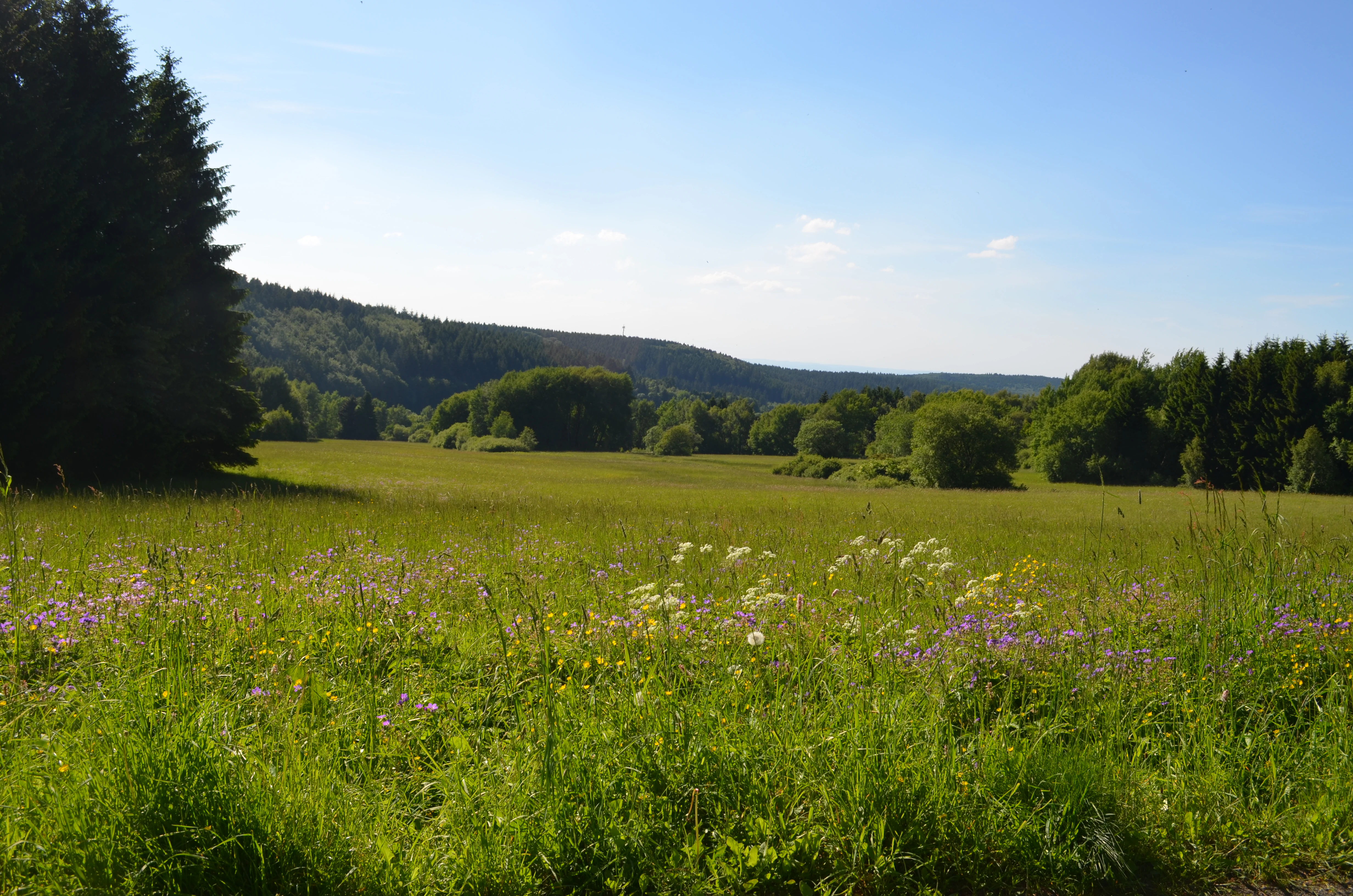
A wide, sunny landscape photograph showing a vibrant green meadow with wildflowers in the foreground, framed by tall conifer trees on the left and a rolling forest-covered hill in the background.
A view of the meadow landscape and surrounding woodland in the Reifenberger Wiesen nature reserve.

Reifenberger Wiesen ecosystems, habitats, and plant life

Ecologically, Reifenberger Wiesen is a refuge of nutrient-poor, species-rich grassland in a region where such habitats have become increasingly rare. The base communities are Magerwiesen, lean meadows whose botanical richness depends on shallow, low-fertility soils. These soils developed partly because of the elevation, gradient, and past grazing history of the site, and they support plant communities that disappear quickly under more intensive land use.

Vegetation in the reserve is characterized by plants typical of traditionally managed grassland, including the Türkenbundlilie (turban lily), Flattergras (wood melick grass), and various Stendelwurz orchids (Epipactis species). The botanical value of the site is closely tied to its historical cultivation as pasture; modern conservation therefore works to maintain that open, semi-managed character. Maintaining the open landscape is an active ecological task, as the hillside would otherwise succeed to shrubs and eventually forest.

The reserve is recognized at the European level through its inclusion in the Natura 2000 network as FFH-Gebiet 5716-304, confirming its significance for habitat types and species of EU-wide conservation concern. The combination of high-elevation meadow, low-nutrient substrates, and historical continuity gives Reifenberger Wiesen a habitat profile that is both regionally characteristic and ecologically distinctive within the Taunus.
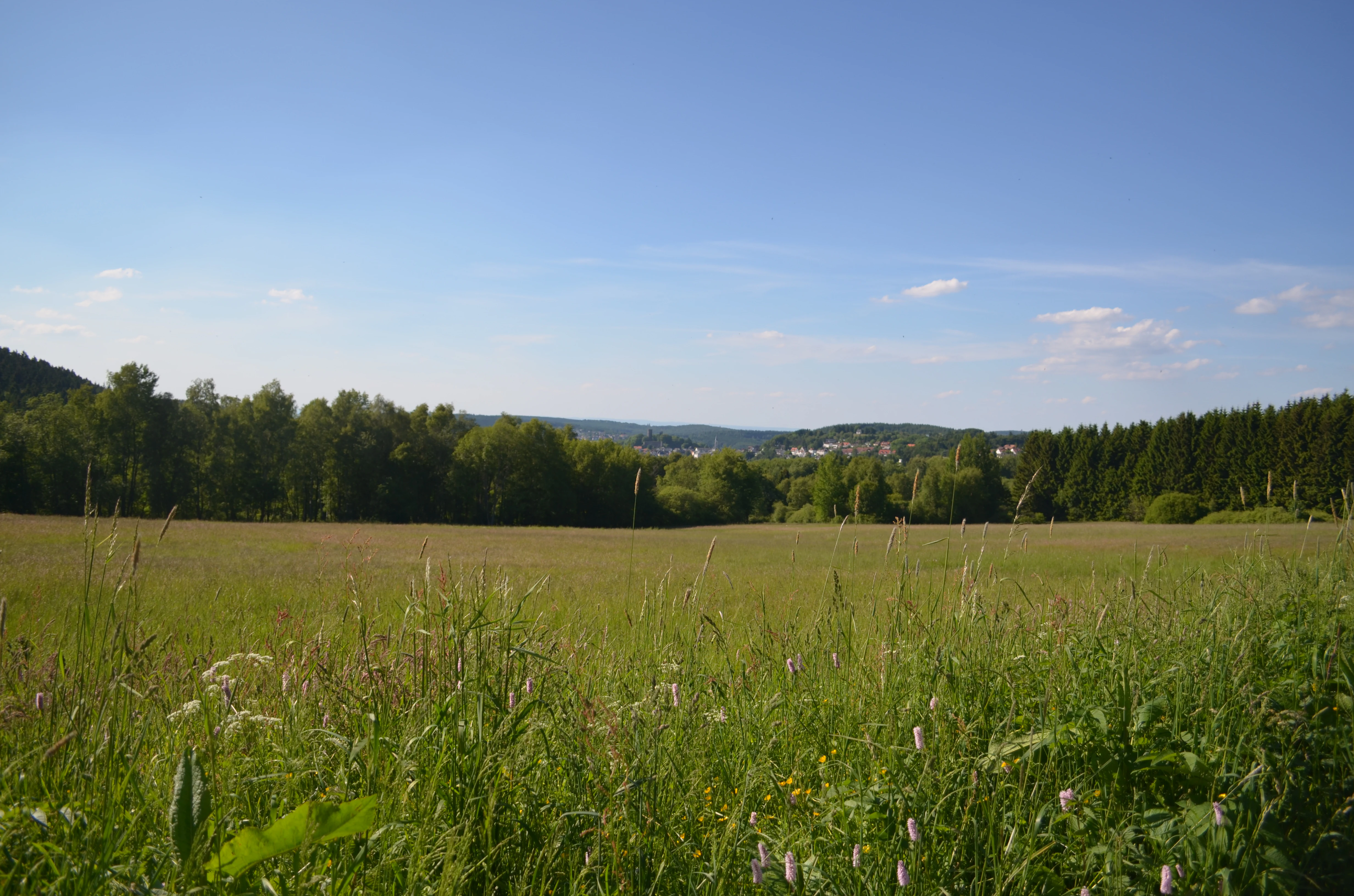
A wide, grassy meadow in the foreground with a line of trees and rolling hills visible in the distance under a blue sky.
A view of the meadows at Reifenberger Wiesen with forested hills in the background.

Reifenberger Wiesen wildlife and species highlights

The reserve functions as an important breeding and retreat area for birds and other small fauna in an otherwise heavily forested highland region. By offering open meadow habitat directly adjacent to woodland, it provides a gradient of structural environments that supports a mix of meadow-nesting birds and forest-edge species.

Animals benefit from the mosaic of dry slopes, moist margins near the Weil river, and the transition zones between meadow and forest edge. The continued presence of meadows, sustained by clearing work such as the 2012 partial deforestation of overgrown areas, ensures that habitat conditions for typical meadow-associated fauna are preserved. Because the reserve is relatively small and surrounded by human settlement and roads, it also serves as a refugium where wildlife can find undisturbed breeding space amid a used landscape.
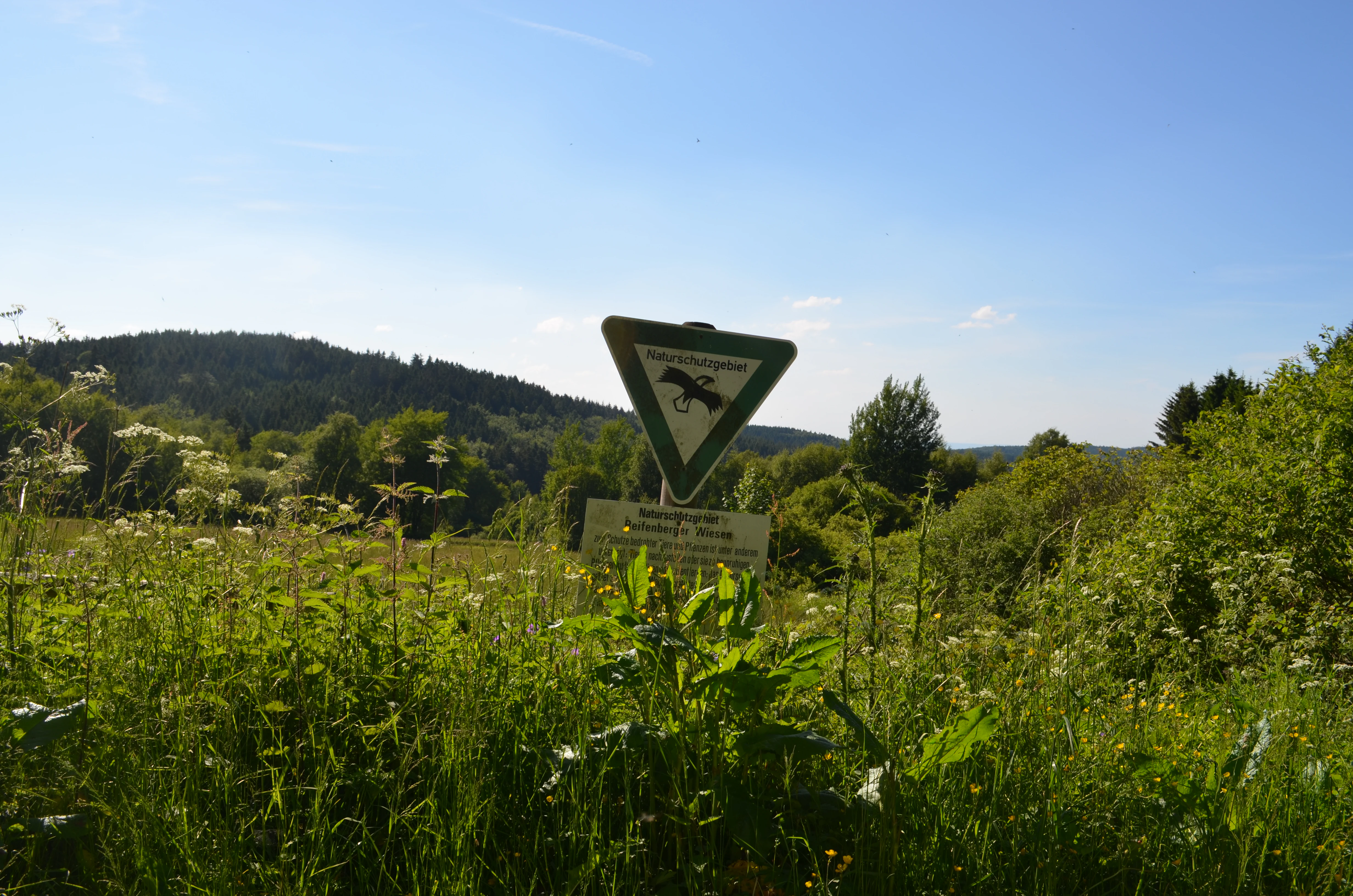
A triangular green and white nature reserve sign on a metal post stands in a lush meadow with a wooded hill in the background.
A nature reserve sign marking the Reifenberger Wiesen area in the Taunus mountains.

Reifenberger Wiesen conservation status and protection priorities

Reifenberger Wiesen has formal nature protection at both the Hessian state level and the European Union level. It was placed under protection as a Naturschutzgebiet in 1983, the standard Hessian designation for site-level nature protection, and has since been recognized as part of the EU Natura 2000 network under the FFH (Flora Fauna Habitat) directive, designated as FFH-Gebiet 5716-304.

The core conservation message of the site is that its current biodiversity depends on maintaining a culturally created landscape. Without continued human intervention in the form of grazing, clearing, or mechanical maintenance, the open meadows of the reserve would gradually be reclaimed by shrubs and trees and convert into forest, with a corresponding loss of the plant species and habitat structures for which the area was protected. This is why, in early 2012, a partial area of about 10 hectares was cleared as an active management measure to preserve open meadow conditions and the species associated with them.

A detailed Bewirtschaftungsplan (management plan) for the FFH area has been drawn up by the Regierungspräsidium Darmstadt, guiding how grazing regimes, timing of interventions, and habitat protection should be coordinated. The reserve thus stands as an example of modern German nature conservation strategy, where legal protection, EU-level habitat policy, and practical landscape management work together to maintain a small but ecologically rich site.

Reifenberger Wiesen cultural meaning and human context

Reifenberger Wiesen is fundamentally a product of rural cultural history rather than untouched nature. The visible mosaic of meadows, settlement edges, and the Limesstraße running along the slope reflects centuries of interaction between Hochtaunus villagers and a difficult upland environment. The local communities of Oberreifenberg and Niederreifenberg once depended on the limited grazing here, and the very existence of the meadows is a legacy of that hardship.

The area also carries more recent cultural layers. The former Bildungs- und Familienstätte Oberreifenberg marks the downhill edge of the reserve, while the nearby Jugendherberge Oberreifenberg and the Naturparkhotel Weilquelle underline the modern role of this part of the Taunus as a recreational and educational landscape. In winter, the Heimliche Wiese within the reserve continues a different kind of cultural use as a ski piste, showing how the same slopes serve conservation, education, and outdoor recreation simultaneously.

Top sights and standout views in Reifenberger Wiesen

The most distinctive highlight of Reifenberger Wiesen is the concentration of botanically rare, nutrient-poor meadow habitat on a north-facing Taunus mountainside. The reserve is a recognized stronghold for the Lanzettblättrige Glockenblume and hosts a recognizable orchid community alongside other specialist meadow plants. Its combination of formal Hessian Naturschutz status and EU Natura 2000 FFH recognition, small protected size, and very specific management history makes it a tight, focused site whose identity is closely tied to the cultural and ecological history of the Feldberg villages.

Best time to visit Reifenberger Wiesen

Reifenberger Wiesen is best appreciated in late spring and early summer, when meadow plants typical of nutrient-poor grassland, including orchids and the Lanzettblättrige Glockenblume, are in bloom and the visual contrast between the open slopes and the forested Großer Feldberg above is most pronounced. The hillside is accessible year-round via local footpaths near the Großer Feldberg summit, but visitors interested in the floral diversity will find the flowering season offers the most rewarding view of what makes the reserve special. In winter, much of the slope is used as ski terrain.
Monthly climate preview

Long-term representative temperature and precipitation averages for Hochtaunuskreis

Reifenberger Wiesen Climate Normals and Monthly Weather Patterns

Reifenberger Wiesen records measured monthly temperature variations alongside steady precipitation rates across the representative coordinate. Exploring the complete twelve-month climate profile reveals detailed averages for annual temperature swings and precipitation distribution.
Annual mean10 °C
0 °C21 °C
Jan
Feb
Mar
Apr10°
May14°
Jun18°
Jul21°
Aug20°
Sep15°
Oct10°
Nov
Dec
Warmest month
July

20.6 °C

Coolest month
January

0.2 °C

Wettest month
July

2.2 mm/day

Driest month
April

1.4 mm/day

Park location guide

Geography guide, regional context, and park location map for Reifenberger Wiesen

Reifenberger Wiesen park geography, regions, and map view in Germany

Understand where Reifenberger Wiesen sits in Germany through a broader geographic reading of the surrounding landscape, nearby location context, and its mapped position within the national park landscape.

How Reifenberger Wiesen fits into Germany

Germany is a federal republic in Western and Central Europe with a population of over 83 million across sixteen constituent states. It is Europe's largest economy by nominal GDP and a major global exporter and importer. The capital is Berlin, and the country borders Denmark, Poland, Czech Republic, Austria, Switzerland, France, Luxembourg, Belgium, and the Netherlands.

Wider geography shaping Reifenberger Wiesen in Germany

Germany is located in Western and Central Europe, spanning 357,022 km². It borders Denmark to the north, Poland and the Czech Republic to the east, Austria and Switzerland to the south, and France, Luxembourg, Belgium, and the Netherlands to the west. The country has coastlines on the Baltic Sea and North Sea to the north, with the Alps located in the southern region.

Map view of Reifenberger Wiesen

Use this park location map to pinpoint Reifenberger Wiesen in Germany, understand its exact geographic position, and read its mapped placement within the surrounding landscape more clearly.

Pigeon | © OpenStreetMap contributors

Location context for Reifenberger Wiesen

Hochtaunuskreis

Explore protected hillside meadows, rare botanical habitats, and high Taunus mountain terrain.

Reifenberger Wiesen Photos and Landscape Scenery Visual Guide

Visual documentation captures the sloping hay meadows, nutrient-poor grassland habitats, and broader protected landscape character of Reifenberger Wiesen. Examining these field photographs reveals the botanical diversity and upland terrain defining this high Taunus nature reserve.

A wide, grassy meadow stretches between two dense walls of forest under a clear blue sky.

A meadow filled with green grasses and bordered by deciduous trees, looking towards a distant forested hill with a mountain summit structure visible on the horizon under a clear blue sky.

A wide, sunny landscape photograph showing a vibrant green meadow with wildflowers in the foreground, framed by tall conifer trees on the left and a rolling forest-covered hill in the background.

A wide, grassy meadow in the foreground with a line of trees and rolling hills visible in the distance under a blue sky.

A triangular green and white nature reserve sign on a metal post stands in a lush meadow with a wooded hill in the background.

A wide landscape view of a meadow in the foreground with a dense forest line and a village with a castle tower in the background under a pale sky.

Park atlas

Compare regional protected areas and neighboring mountain reserves

Other Parks Near Reifenberger Wiesen and Connected Protected Landscapes

Browsing parks near Reifenberger Wiesen reveals the wider network of protected landscapes across the surrounding region. Comparing these neighboring habitats provides deeper context for upland meadow ecology and regional conservation terrain.
Watercolor painting depicting a landscape with rolling hills in the background and trees in autumn colors in the midground.
Nature reserveHochtaunuskreis
About 4.9 km away#1 closest

North

Saubach und Niedgesbach bei Schmitten Nature Reserve: High Taunus Landscape Geography

Mapped protected valleys in the Hochtaunuskreis region.

This nature reserve protects the parallel stream valleys of the Saubach and Niedgesbach near the village of Schmitten. The site is a significant example of High Taunus upland ecology, where abandoned pastoral land has fostered unique plant diversity. It remains a key focal point for understanding the transition of cultural landscapes into protected wild habitats within the Hochtaunuskreis.

Area
0.58 km²
Established
1995
A horizontal watercolor painting showing a soft, impressionistic landscape with rolling green hills and patches of forest under a pale, muted sky.
Nature reserveHessen
About 5.1 km away#2 closest

Southeast

Burghain Falkenstein Nature Reserve: Protected Woodland Map and Regional Geography

A forest enclave in the Taunus uplands of Hessen, Germany

Burghain Falkenstein stands as a prominent nature reserve and Natura 2000 site located on the slopes of the Burgberg. This compact protected area features a mosaic of beech and ravine forests, providing a rare green massif amidst the urban sprawl of the Taunus foothills. The reserve documents a complex history where natural woodland succession intersects with medieval fortification remains, offering a concentrated study of regional forest geography near Frankfurt am Main.

Area
0.363 km²
Established
1966
IUCN
IV
Relief
Mountain
Nature reserveHessen
About 6.8 km away#3 closest

South

Krebsbachtal bei Ruppertshain: Protected Stream Valley and Conservation Geography

Nature reserve and FFH site in the Hessian Taunus

Located in the western foothills of the Taunus, Krebsbachtal bei Ruppertshain is a protected nature reserve and Natura 2000 site. It features a linear valley landscape defined by the Fischbach stream corridor and dense mixed deciduous forest. The reserve plays a crucial role in maintaining regional ecological continuity within the Rhine-Main area, providing a distinct geographic boundary near the Rossert massif.

Area
0.845 km²
Established
1992
IUCN
IV
Relief
Upland
A watercolor illustration of a serene valley landscape with a small winding stream running through grassy meadows, bordered by trees in the distance.
Nature reserveHesse
About 7.4 km away#4 closest

Southwest

Dattenbachtal zwischen Kröftel und Vockenhausen Nature Reserve in Hesse, Germany

Stream valley and protected riparian landscape mapping

This nature reserve protects a vital section of the Dattenbach stream valley between the villages of Kröftel and Vockenhausen. Spanning cross-district boundaries in the Taunus foothills, the site is defined by its two-parcel structure and its role in preserving headwater stream habitats within the larger Hessian landscape.

Area
0.909 km²
Established
1993
A soft watercolor painting depicting rolling green hills and a forested landscape under a pale, sunrise-hued sky.
Nature reserveHessen
About 7.9 km away#5 closest

Southwest

Rossert - Hainkopf - Dachsbau Nature Reserve: Geography and Protected Taunus Forest Landscapes

A preserved ridge system in the Hessen region of Germany

The Rossert - Hainkopf - Dachsbau nature reserve represents a compact but ecologically vital ridge system in the Taunus foothills. Spanning over 120 hectares of mixed forest, this protected area preserves the transition between woodland and open meadow while securing the headwaters of the Wellbach stream within its geographic boundaries.

Area
1.19 km²
Established
1977
IUCN
IV
A watercolor painting of a rolling landscape featuring open fields in the foreground, distant hills, and a cluster of pine and deciduous trees on the right side.
Nature reserveHochtaunuskreis
About 9 km away#6 closest

Northwest

Riedelbacher Heide Nature Reserve: Geographic Map and Landscape Analysis of the Taunus

A preserved open heathland within the forested Hintertaunus uplands

Riedelbacher Heide offers a focused look at an 8.4 hectare nature reserve located on the high plateau of the eastern Hintertaunus. This area provides valuable insight into the ecological and cultural history of the Taunus, where historical grazing practices shaped a distinctive mosaic of open, sun-exposed vegetation. The reserve serves as a critical example of traditional land management in a predominantly forested low-mountain geography.

Area
0.084 km²
Established
1969
A horizontal watercolor painting depicting a gentle stream flowing through a lush meadow with trees and hills in the background.
Nature reserveHessen
About 9.9 km away#7 closest

Northwest

Oberes Dombachtal Nature Reserve: Valley Geography and Protected Landscapes in Hessen

Mapping rare floodplain habitats in the eastern Taunus foothills

Oberes Dombachtal protects a specialized valley system characterized by relict alder woodland, purple moor-grass stands, and near-natural stream segments. Located in the eastern Taunus, the reserve serves as a crucial link for local biodiversity, offering a concentrated look at the valley-floor ecosystems that define this part of the Hessen landscape. Its geography demonstrates the importance of small-scale corridor protection for stream health.

Area
0.187 km²
Established
1995
IUCN
IV
Relief
Upland
A watercolor painting showing rolling green meadows, trees, and soft distant hills against a white background.
Nature reserveHessen
About 11 km away#8 closest

East

Kirdorfer Feld bei Bad Homburg: Protected Cultural Landscape and Meadow Reserve Map

Nature reserve and Natura 2000 protected land in Hessen

Kirdorfer Feld bei Bad Homburg serves as a prime example of an intact agricultural cultural landscape, defined by its traditional Streuobstwiesen orchards, damp meadow corridors, and spring-fed wetlands. This site acts as a key ecological anchor within the Taunus foothills, showcasing a unique interplay between managed farmland and protected botanical communities. Learn about the geographic composition of this designated Natura 2000 site.

Area
1.6 km²
Established
1996
Relief
Lowland
Scope
Terrestrial

Common questions about visiting, size, designation, and location context for Reifenberger Wiesen

Reifenberger Wiesen FAQs for park facts, access, geography, and protected area context

Find quick answers about Reifenberger Wiesen, including protected-area facts, park geography, trail and visitor context, and how the park fits into its surrounding country and regional landscape.
MoriAtlas Explorer

Continue Your Protected Areas Search Across the Global Atlas

Deepen your exploration by continuing the structured search for national parks and protected areas worldwide. Utilize the comprehensive filtering capabilities to compare different conservation landscapes and refine your understanding of global park geography. Discover more about the distribution and characteristics of protected natural areas.

Global natural geography