
Mori Atlas logo
Nature reserveReinheimer Teich

A regional wetland sanctuary in the Reinheimer Becken supporting specialized pond and meadow habitats

Reinheimer Teich Nature Reserve and Wetland Landscape Geography in Southern Hesse, Germany

(Naturschutzgebiet Reinheimer Teich)

Reinheimer Teich is a protected nature reserve located within the Reinheimer Becken of southern Hesse. This low-lying wetland landscape covers 75 hectares of open water, reed beds, and marshy pastures that serve as a critical refuge for rare European pond turtles and diverse waterbird populations. As a core component of the broader Untere Gersprenz Natura 2000 network, the area provides essential habitat connectivity across the flat, sediment-rich riverine terrain near the Odenwald.

wetland reservelowland wetlandreeds and marshespondswet meadowsbirdwatching
A colorful, flat vector-style illustration of a peaceful nature landscape showing a calm stream or pond surrounded by tall grass, reeds, trees, and cliffs with a small waterfall in the background.

Reinheimer Teich

Nature reserve

Park overview

Structured park overview, official facts, and landscape profile for Reinheimer Teich

Reinheimer Teich park facts, protected area profile, and essential visitor context

Review the core facts for Reinheimer Teich, including designation, size, terrain, visitor scale, habitats, and operating context in one park-focused overview.

About Reinheimer Teich

Reinheimer Teich is a compact but ecologically dense nature reserve in the southern Hessian lowlands, situated just outside the town of Reinheim and a short distance from the western edge of the Odenwald. Despite occupying only about 75 hectares, it combines an unusually varied mosaic of open water, reed-fringed shorelines, wet meadows, and lightly grazed pasture that together create conditions increasingly rare in the heavily cultivated Rhine-Main region.

The site's character is strongly shaped by water. Several artificial ponds, originally created in the early 17th century, were re-engineered in the 1970s and now include both deep and shallow zones, which support different aquatic communities and provide safe resting areas for birds and turtles. Reed beds and wet meadows ring much of the open water, while the surrounding landscape of the Reinheimer Becken has remained largely open and rural, giving the reserve a sense of space and quiet that is unusual so close to major urban centers.

Ecologically, Reinheimer Teich stands out for its combination of regionally rare reptile, amphibian, and bird populations. The reserve is the heart of the Natura 2000 sites Untere Gersprenz and Untere Gersprenzaue, linking its small protected footprint to a much larger protected landscape along the Gersprenz catchment. The presence of a working volunteer-run interpretation center, the Naturschutzscheune, further reinforces the area's role not just as a habitat but also as a place where conservation practice, public education, and community involvement come together.

Quick facts and research context for Reinheimer Teich

Reinheimer Teich is a German nature reserve (Naturschutzgebiet) established on 19 December 1975 in the Landkreis Darmstadt-Dieburg in the state of Hesse. It spans around 75 hectares and lies at roughly 150 to 153 meters above sea level in the flat Reinheimer Becken just north of the Odenwald.

Its substrate is made up of Holocene sandy and silty sediments left by the Gersprenz river and its tributaries, with Pleistocene gravels covered by loam appearing in the western part of the reserve. The area is constructed around artificial fish ponds dating back to the 17th century and was deliberately re-flooded and dredged in the 1970s to create a modern wetland mosaic of deep and shallow water, reed beds, and wet grassland. It is registered internationally with WDPA ID 82390 and is classified as an IUCN Category IV Habitat/Species Management Area.

Protection and recognition

Examine documented terrestrial protection metrics and official registry records.

Reinheimer Teich Protection Status and International Recognition Data

Reinheimer Teich maintains a recorded terrestrial protection status within global conservation databases. Verified registry records outline the documented management scope and official recognition details associated with the protected landscape.

Protection details

Protection scope
Terrestrial
Transboundary protection
No
WDPA ID
82390
Park context

Deeper park guide and search-rich context for Reinheimer Teich

Reinheimer Teich history, landscape, wildlife, and travel context

Explore Reinheimer Teich through its history, landscape character, ecosystems, wildlife, conservation priorities, cultural context, and seasonal travel timing in a structured park guide built for atlas discovery and search intent.

Why Reinheimer Teich stands out

Reinheimer Teich is especially known as one of the last places in Hesse where the European pond turtle still has an autochthonous population, with documented nesting sites, basking areas, and migration routes studied by the University of Frankfurt. The reserve is also a regional stronghold for waterbirds and meadow birds, hosting a grey heron colony, breeding white storks, and seasonal visits by species such as great egrets, bitterns, and hen harriers.
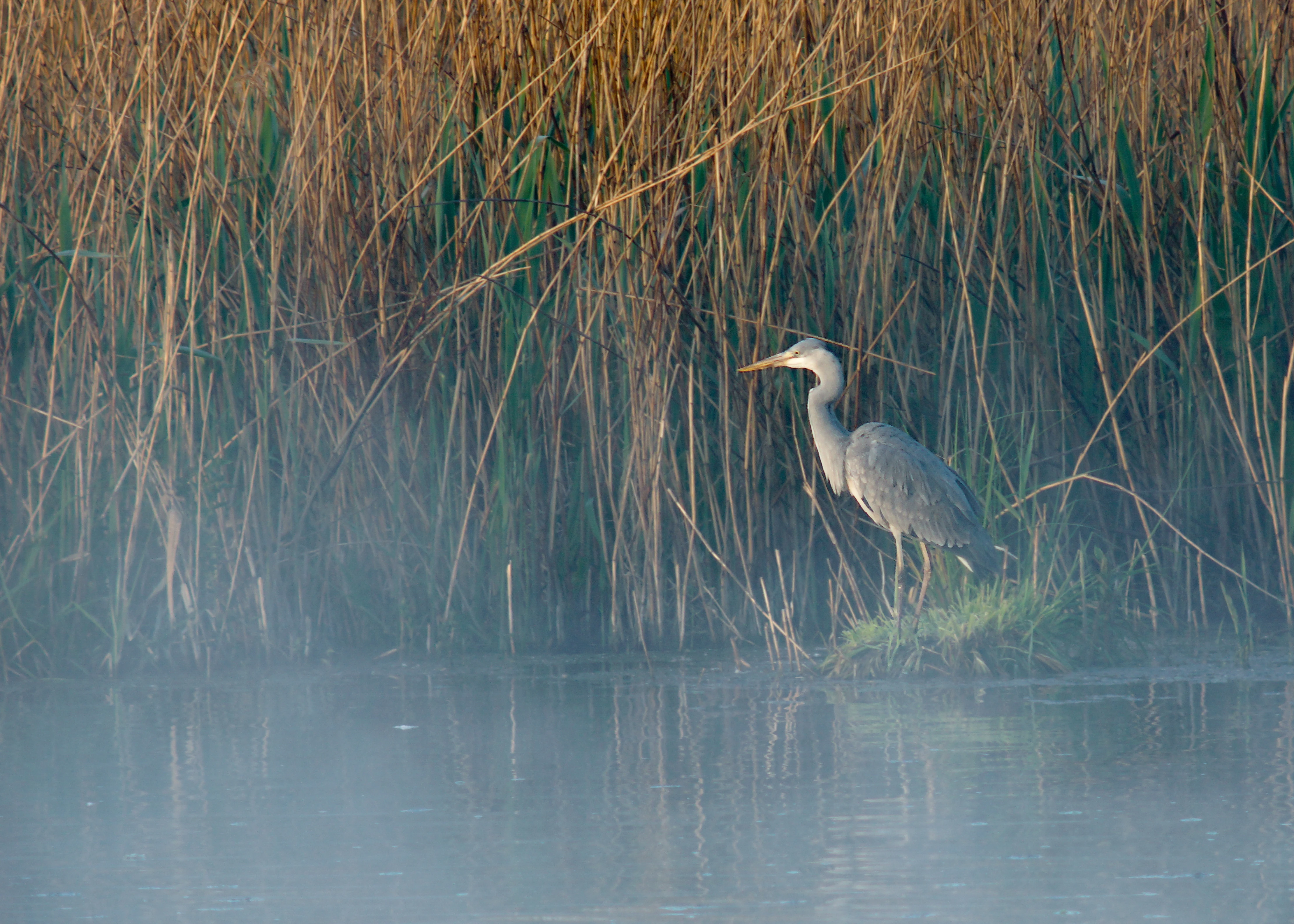
A grey heron standing on a small patch of grass at the edge of a water body, with tall reeds in the background and a layer of light morning mist over the water.
A grey heron standing near the reed beds at Reinheimer Teich in the early morning.

Reinheimer Teich history and protected-area timeline

The reserve's modern identity rests on a much older cultural landscape. Before it became a protected area, the wetland was known as the Reinheimer Bruch and was used for grazing and haymaking. In 1625 the communities of Reinheim and Spachbrücken sold what was then a marshy area to Landgrave Ludwig V of Hesse-Darmstadt, and from 1626 onward, under Landgrave Georg II, the pond master Barthold Mayer built a series of carp and pike ponds, dammed the area, and brought in water from the Wembach and the Gersprenz.

For the next two centuries, the site alternated between fish farming and grassland use, until it passed back to the community of Reinheim in 1910, where it was once again managed primarily as pasture and hay meadow. This long history of mixed use shaped the patchwork of ponds, ditches, and meadows that the modern reserve inherited.

The decisive moment came on 19 December 1975, when the area was formally designated as the Naturschutzgebiet Reinheimer Teich. In 1976 and 1977, conservation managers rebuilt the hydrology by raising water levels and excavating new basins, reintroducing the mix of deep and shallow water that defines the reserve today. In 2005, the NABU and the Hessische Gesellschaft für Ornithologie und Naturschutz (HGON) opened the Naturschutzscheune visitor center in a converted agricultural building, anchoring a long tradition of volunteer-driven conservation and education on the site.

Reinheimer Teich landscape and geographic character

Reinheimer Teich lies in a very gentle, almost flat section of the Reinheimer Becken, the broad lowland that forms the northwestern foreland of the Odenwald. At around 150 to 153 meters above sea level, the reserve sits low in the landscape, with no prominent hills or steep slopes within the protected area itself; instead, the visual character comes from horizontal expanses of water, reed, and meadow framed by low embankments and subtle changes in vegetation.

The underlying geology is dominated by Holocene sandy and silty sediments deposited by the Gersprenz and its tributaries. Along the western edge of the reserve, these younger deposits give way to older Pleistocene gravels mantled with loam, creating slightly different soil conditions. A system of embankments, originally built to support the historic fish ponds, still defines much of the boundary, while a network of drainage ditches carries water northward toward the Gersprenz.

Away from the water, the wider setting transitions gently into agricultural fields, the nearby Reinheim gliding airfield, and the hamlets of Spachbrücken and Reinheim. The result is a landscape that feels open and pastoral rather than dramatic: a mosaic of still water, reed beds, and grasslands under the wide southern Hessian sky, with the wooded slopes of the Odenwald visible in the distance as a low, forested horizon.
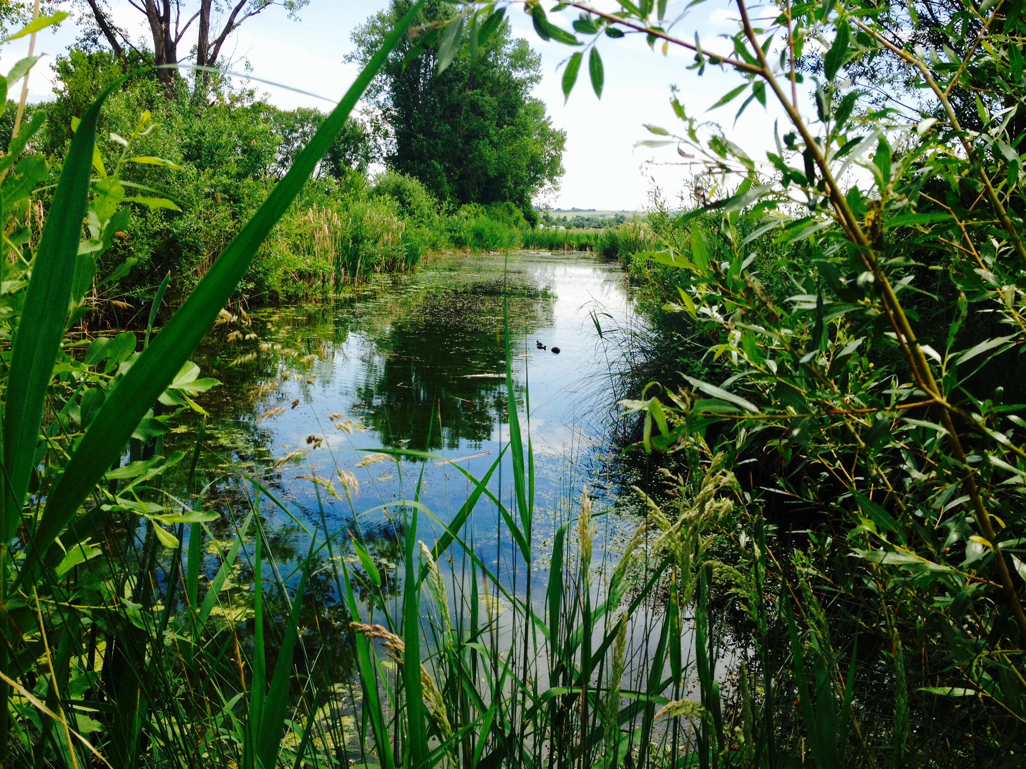
A narrow, calm channel of water at Reinheimer Teich, framed by tall grasses and willow branches in the foreground, with trees lining the banks.
A peaceful view of the Reinheimer Teich nature reserve, featuring a narrow waterway surrounded by lush riparian vegetation.

Reinheimer Teich ecosystems, habitats, and plant life

The reserve's ecological identity is built around the wetland mosaic. Open water, reed belts, wet meadows, and extensively grazed grassland each contribute different habitats, and because they sit immediately next to one another, the site supports an unusually rich combination of aquatic, semi-aquatic, and terrestrial species for its modest size. Periodic rewetting and careful management of grazing intensity help maintain the balance between open water, emergent vegetation, and meadow.

Vegetation along the shorelines and in the wet meadows includes species such as broad-leaved marsh orchid, black-headed sedge, strawberry clover, and marsh violet, alongside twelve documented threatened plant species. The transition from open water through reed to meadow creates classic ecological gradients that, in central Europe, are increasingly confined to dedicated protected areas like this one.

At a broader landscape scale, Reinheimer Teich functions as a key node in the Natura 2000 ecological network. It is the central component of both the Untere Gersprenz FFH site and the Untere Gersprenzaue EU Bird Directive site, meaning that the reserve's small footprint multiplies across the larger floodplain of the lower Gersprenz. This linkage between local wetland management and European-scale habitat networks is central to the reserve's nature conservation role.
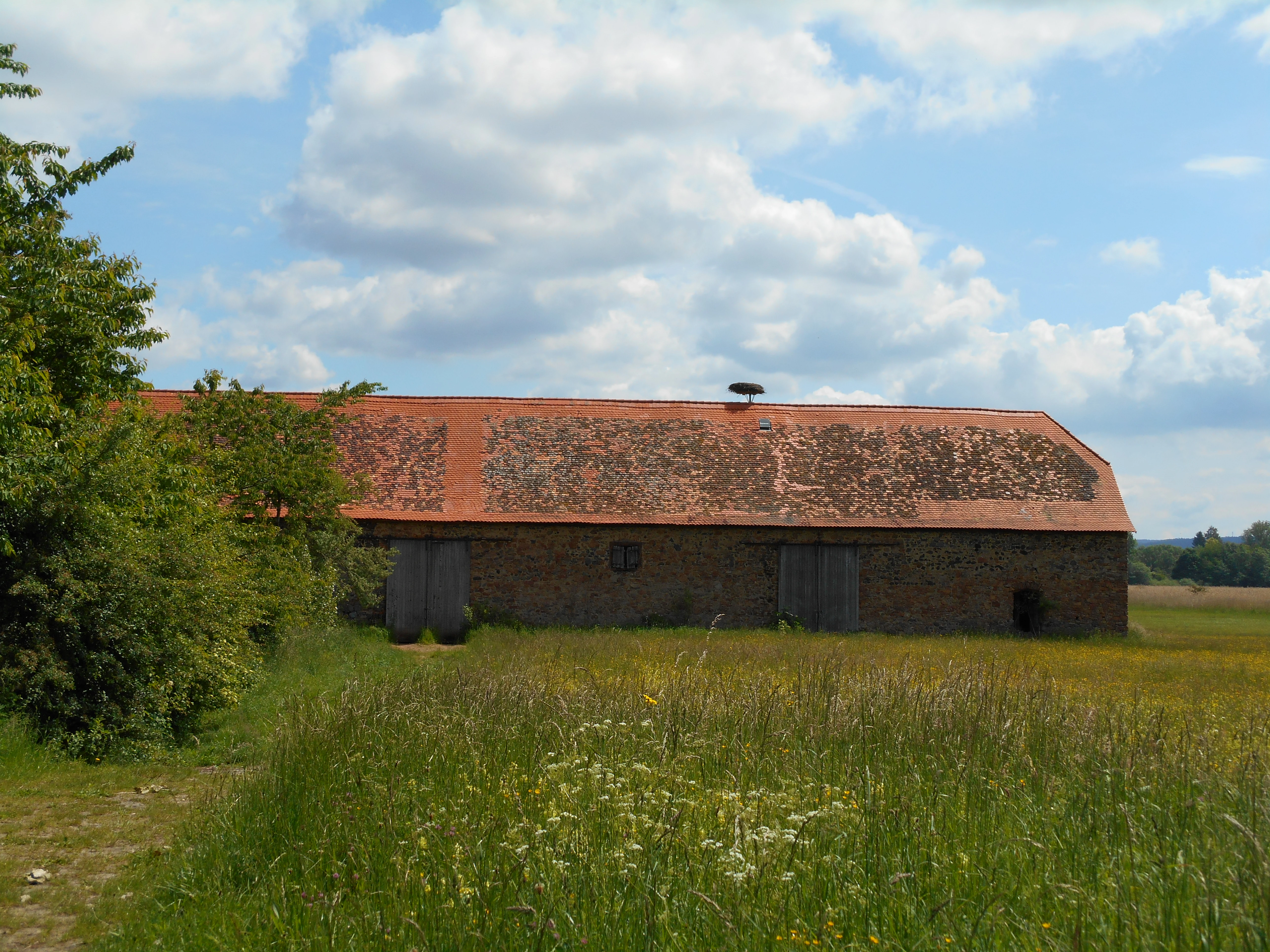
A long, single-story brick barn with a red tile roof stands in a field of tall meadow grass under a blue sky with white clouds.
The historical Teichscheune barn located within the Reinheimer Teich nature reserve.

Reinheimer Teich wildlife and species highlights

Wildlife is the most prominent feature of Reinheimer Teich. The reserve hosts around 101 bird species, of which roughly 64 breed in or near the area, including white storks that nest on the historic Teichscheune building, a resident grey heron colony, marsh harriers, and a wide range of waterbirds and meadow birds. The site's mix of reeds and open water also attracts bitterns, great egrets, and hen harriers as passage or winter visitors, while dabbling ducks and other waterfowl use the ponds throughout the year.

Beyond birds, the reserve supports a diverse aquatic and semi-aquatic fauna. Twelve fish species, six amphibian species including the European tree frog, four bat species, twenty-one dragonfly species, sixteen grasshopper species, twenty-eight butterfly species, and a remarkable 120 spider species have been recorded. The beetle fauna is similarly well documented, with 89 ground beetle species identified, many of them of conservation interest. Eurasian beavers have returned to the area, leaving visible marks on trees along the water's edge.

The reserve's most distinctive wildlife value, however, is its population of the European pond turtle. Reinheimer Teich holds one of the last known autochthonous occurrences of this reptile in Hesse, with documented nesting sites, basking areas, and movement corridors that have been tracked in studies run by the University of Frankfurt, including through radio telemetry. The confirmed hatching of a young turtle at the Naturschutzscheune in 2014 was a major milestone for the local conservation community.
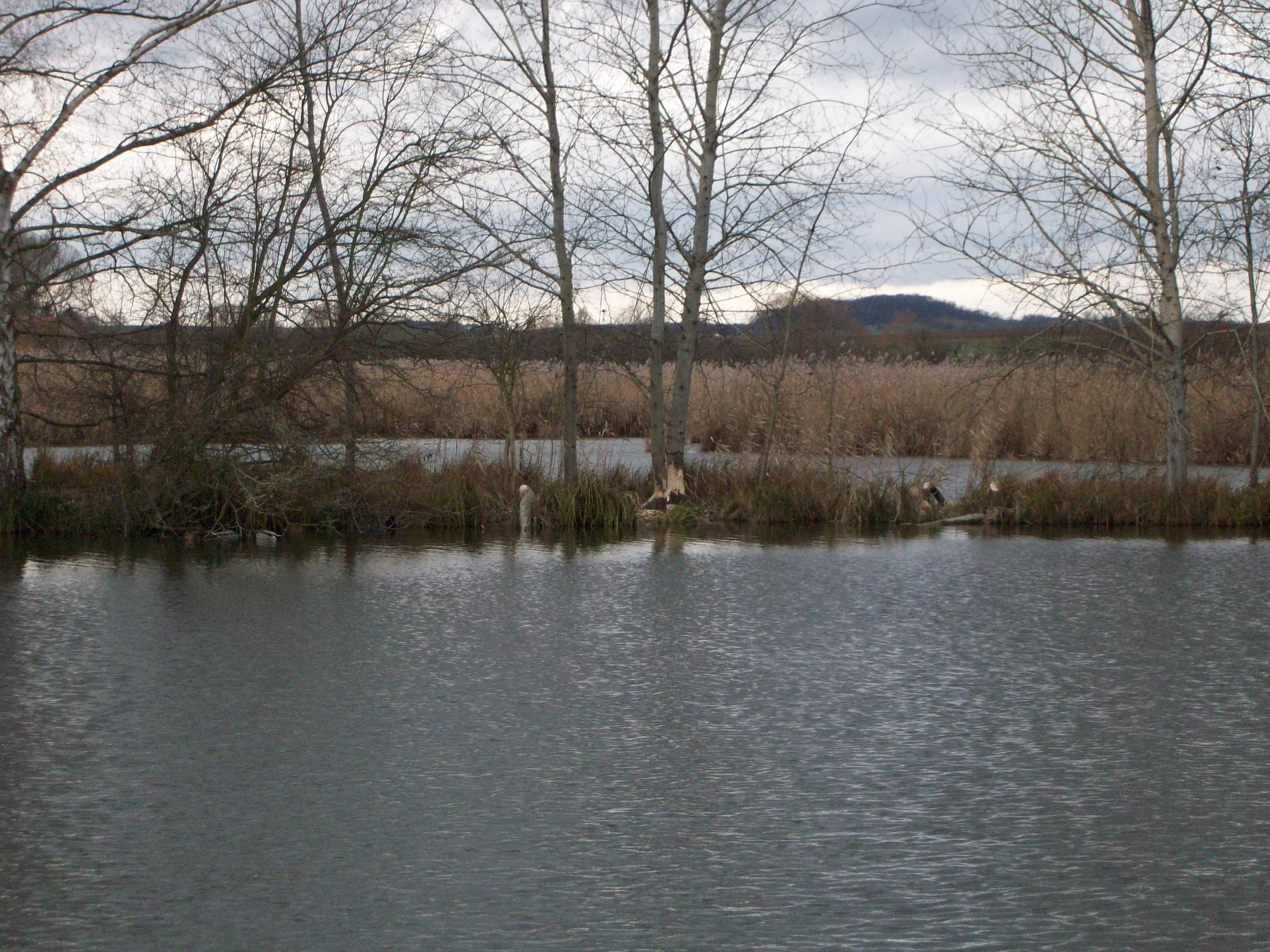
A beaver sitting on the muddy bank of a pond in a nature reserve, surrounded by reeds and bare trees.
A beaver observed in the Reinheimer Teich nature reserve.

Reinheimer Teich conservation status and protection priorities

Reinheimer Teich is a nationally and internationally recognized wetland conservation site. At the national level it is a designated Naturschutzgebiet under Hessian nature conservation law, with formal protection dating back to 1975 and an IUCN Category IV (Habitat/Species Management Area) designation. At the European level, it sits within both the Natura 2000 FFH site Untere Gersprenz and the EU Birds Directive site Untere Gersprenzaue, connecting local protection to a continent-wide ecological network.

Active management is a core part of the reserve's conservation identity. Since the late 1970s, water regimes have been deliberately engineered, with controlled flooding and excavation creating and maintaining a patchwork of deep, shallow, and emergent water zones that sustain aquatic reptiles, amphibians, and invertebrates. Grazing is used as a tool to keep meadows open and prevent scrub encroachment, while ditches and embankments are managed to support the wetland hydrology rather than drain it.

The reserve is also a focus of targeted species conservation. The European pond turtle population has been the subject of long-term study by the University of Frankfurt, including tracking of individuals with transmitters to identify migration routes, nesting sites, and basking locations, work that has informed protective management of banks, shores, and surrounding fields. The site's volunteer-run Naturschutzscheune, operated by NABU and HGON, complements these efforts by turning the reserve into a working outdoor classroom where conservation practice and public engagement reinforce one another.

Reinheimer Teich cultural meaning and human context

The cultural history of Reinheimer Teich is closely tied to the long human presence in the Reinheimer Becken. Long before it became a nature reserve, the wetland known as the Reinheimer Bruch was a shared commons used for haymaking and grazing by the communities of Reinheim and Spachbrücken. The construction of fish ponds under Landgrave Georg II in the 1620s introduced a new chapter of structured land use that, while economic in intent, also produced the very pond-and-dike landscape that the modern reserve later inherited.

The historic Teichscheune, an old agricultural hall once associated with pond management, remains a cultural landmark of the area and now hosts white stork nesting on its roof. Its conversion into the Naturschutzscheune in 2005, run by NABU and HGON with the help of volunteers, is a notable example of how a building rooted in traditional rural land use has been reinterpreted as a center for citizen-led nature conservation.

Today the reserve sits within an agricultural and recreational landscape that includes the nearby Reinheim gliding airfield and the trail network of the Darmstadt-Dieburg district's BioTopTour, with both walking and cycling routes connecting the site to the wider region. This blending of working landscape, light aviation heritage, and nature-based recreation reflects the role of the Reinheimer Becken as a place where conservation, traditional land use, and everyday local life continue to overlap.

Top sights and standout views in Reinheimer Teich

Reinheimer Teich's standout qualities lie in the unusual concentration of rarely combined species and habitats packed into a small lowland reserve. The combination of a self-sustaining European pond turtle population, a meaningful breeding bird community including white storks and a grey heron colony, and a return of beavers gives the site a near-pristine wetland character that is hard to match elsewhere in Hesse.

Equally important is the reserve's status as the core of the Untere Gersprenz and Untere Gersprenzaue Natura 2000 sites, which embed its local protection within the larger floodplain landscape of the lower Gersprenz. The presence of the volunteer-run Naturschutzscheune visitor center, with its on-site interpretation, biotope garden, and active role in species monitoring, adds a strong practical dimension to these ecological highlights, making the reserve both a refuge for wildlife and a working hub for conservation in the region.

Best time to visit Reinheimer Teich

Reinheimer Teich can be visited throughout the year, but the character of a visit changes noticeably with the seasons. Spring and early summer are the most rewarding periods for birdwatching, with breeding waterbirds, marsh harriers, and reedbed species active around the ponds, and white storks visible at the historic Teichscheune. The Naturschutzscheune visitor center is open on Sundays and public holidays during the summer half of the year, when changing exhibitions, guided walks, and talks are available.

Autumn and winter bring their own appeal: migratory waterbirds, geese, and species such as great egrets and hen harriers use the open water and meadows as resting or wintering habitat, while the bare reeds and quiet pond landscapes offer a calmer, more meditative experience. Light levels tend to be soft and atmospheric, and the flat landscape is easy to explore along the roughly three-kilometer circular trail that surrounds the reserve.

Monthly climate preview

Long-term temperature and precipitation patterns across the representative coordinate

Reinheimer Teich Climate Normals and Measured Weather by Month

Representative coordinate measurements record monthly mean temperatures ranging from near freezing to warm midyear maximums alongside steady precipitation rates. Reviewing the complete twelve-month profile clarifies annual weather patterns and long-term averages for Reinheimer Teich.
Annual mean10 °C
0 °C21 °C
Jan
Feb
Mar
Apr10°
May14°
Jun18°
Jul21°
Aug20°
Sep15°
Oct10°
Nov
Dec
Warmest month
July

20.6 °C

Coolest month
January

0.2 °C

Wettest month
July

2.2 mm/day

Driest month
April

1.4 mm/day

Park location guide

Geography guide, regional context, and park location map for Reinheimer Teich

Reinheimer Teich park geography, regions, and map view in Germany

Understand where Reinheimer Teich sits in Germany through a broader geographic reading of the surrounding landscape, nearby location context, and its mapped position within the national park landscape.

How Reinheimer Teich fits into Germany

Germany is a federal republic in Western and Central Europe with a population of over 83 million across sixteen constituent states. It is Europe's largest economy by nominal GDP and a major global exporter and importer. The capital is Berlin, and the country borders Denmark, Poland, Czech Republic, Austria, Switzerland, France, Luxembourg, Belgium, and the Netherlands.

Wider geography shaping Reinheimer Teich in Germany

Germany is located in Western and Central Europe, spanning 357,022 km². It borders Denmark to the north, Poland and the Czech Republic to the east, Austria and Switzerland to the south, and France, Luxembourg, Belgium, and the Netherlands to the west. The country has coastlines on the Baltic Sea and North Sea to the north, with the Alps located in the southern region.

Map view of Reinheimer Teich

Use this park location map to pinpoint Reinheimer Teich in Germany, understand its exact geographic position, and read its mapped placement within the surrounding landscape more clearly.

Pigeon | © OpenStreetMap contributors

Location context for Reinheimer Teich

Hesse

Explore mapped terrain, open water habitats, and regional conservation views

Reinheimer Teich Photos and Landscape Scenery: Visualizing the Protected Wetland

Visual documentation reveals the flat lowland topography, extensive reed beds, and open water channels defining the protected wetland. Photographic records provide clear environmental context for the specialized habitats supporting rare turtle populations and migratory waterbirds across the valley.

A grey heron standing on a small patch of grass at the edge of a water body, with tall reeds in the background and a layer of light morning mist over the water.

A calm lake reflecting a sunset sky with silhouettes of reeds and distant trees on the horizon.

A narrow, calm channel of water at Reinheimer Teich, framed by tall grasses and willow branches in the foreground, with trees lining the banks.

A long, single-story brick barn with a red tile roof stands in a field of tall meadow grass under a blue sky with white clouds.

A beaver sitting on the muddy bank of a pond in a nature reserve, surrounded by reeds and bare trees.

Park atlas

Compare surrounding lowland wetlands and regional protected areas in southern Hesse

Other Parks Near Reinheimer Teich and Related Protected Landscapes

Browse other parks near Reinheimer Teich to discover adjacent wetland reserves and connected lowland habitats across the surrounding region. Comparing related protected landscapes provides deeper context on regional river valleys and local conservation networks.
A wide watercolor painting showing a river flowing through a green meadow with trees and distant hills.
Protected areaHesse
About 1.6 km away#1 closest

North

Scheelhecke von Groß-Zimmern Protected Area, Hesse: A Wetland and Riverine Landscape Study

Key protected wetland features in the Reinheimer Hügelland

Scheelhecke von Groß-Zimmern protects an essential network of wet meadows and brook corridors in the Darmstadt-Dieburg district. Its geography encompasses a transition from open sedge-dominated floodplain to softwood forest, providing critical support for avian species and amphibians within the Natura 2000 Gersprenz network.

Area
0.046 km²
Established
1983
Relief
Upland
Climate
Temperate
A soft watercolor illustration depicting a green, hilly landscape with meadows and distant low slopes on a white background.
Nature reserveHesse
About 4.6 km away#2 closest

South

Forstberg von Ueberau: A Volcanic Nature Reserve and Protected Landscape in Hesse, Germany

Geographic atlas of an extinct volcano and dry grassland refuge.

Forstberg von Ueberau serves as a vital ecological anchor within the Reinheimer Hügelland. This 30-hectare nature reserve preserves an unusual volcanic substrate, featuring a crater-shaped basalt quarry surrounded by seminatural meadows and hedgerows. The site stands as a prime example of habitat management where traditional agricultural practices and biodiversity protection converge to sustain Red List species in a structured, open-country setting.

Area
0.305 km²
Established
1990
IUCN
IV
A horizontal watercolor painting depicting a soft-focus landscape with rolling green hills, a marshy foreground with grasses, and light purple mountains in the distance.
Nature reserveHesse
About 6.5 km away#3 closest

North

Das große Hörmes bei Dieburg Nature Reserve: A Wetland Protected Area in Hesse

Mapped lowland wetland habitat in the Gersprenz district

This compact nature reserve in southern Hesse provides a essential sanctuary for wetland species, featuring a rare combination of reedbeds, sedge stands, and moist litter meadows. The area highlights the historical character of the Gersprenz lowlands through its protected hydrological network and open herbaceous habitat structure.

Area
0.136 km²
Established
1985
IUCN
IV
Watercolor painting of a soft, hazy landscape featuring scattered trees, bushes, and rolling hills in shades of green and pink against a pale background.
Nature reserveHesse
About 7.9 km away#4 closest

North

Fohlenweide von Dieburg: Nature Reserve and Protected Landscape in Hesse, Germany

Mapping the wet meadow habitats and ecological boundaries of southern Hesse.

Located in the Darmstadt-Dieburg district, Fohlenweide von Dieburg is a refined example of a small-scale cultural landscape preserved for its high ecological value. The protected area features a unique mosaic of damp grasslands, forest margins, and riparian strips that support a range of wildlife. This site offers insight into regional conservation management in Central Europe.

Area
0.235 km²
Established
1989
IUCN
IV
Relief
Lowland
Watercolor painting of a wide, low-horizon landscape featuring a line of green trees against a pale pink sky over a pale, sandy foreground.
Nature reserveHessen
About 8.9 km away#5 closest

East

Sandsteinbrüche am Burzelberg bei Frau-Nauses Protected Nature Reserve and Quarry Atlas

Odenwald mountain range, Hessen protected area

Examine the geography of Sandsteinbrüche am Burzelberg bei Frau-Nauses, a protected nature reserve in Hessen. This site features striking Buntsandstein quarry walls and rewilded forest edges, providing a specialized environment for cliff-nesting raptors and documenting local industrial history through its geological formations.

Area
0.195 km²
Established
1994
Relief
Upland
Climate
Temperate
A horizontal watercolor painting depicting a soft-focus landscape with green fields, patches of wildflowers, and distant low hills.
Nature reserveHessen
About 9.2 km away#6 closest

North

Auf dem Sand zwischen Hergershausen und Altheim Protected Nature Reserve in Hessen

Inland dune and floodplain landscape mapping

Explore the geography of Auf dem Sand zwischen Hergershausen und Altheim, a nature reserve in Hessen. The area serves as a critical habitat mosaic, featuring sandy inland dunes, expansive wet grasslands, and renaturalized floodplain terrain within the Gersprenz valley.

Area
0.233 km²
Established
1998
IUCN
IV
A soft watercolor painting of a winding stream through a green wetland with trees and distant hills in the background.
Nature reserveHessen
About 9.3 km away#7 closest

North

Faulbruch von Münster Nature Reserve: Hessen Wetland and Forest Geography

Mapped protected landscapes in southern Germany.

Discover the geographic composition of Faulbruch von Münster, a protected nature reserve in Hessen. This area features a distinctive mix of alder swamp forest and wet meadows, providing a valuable habitat within the Rhine-Main region. Analyze the terrain, forest patches, and wetland boundaries through our detailed regional atlas.

Area
0.77 km²
Established
1985
IUCN
IV
A soft watercolor illustration depicting a meadow landscape with a winding stream, distant hills, and foreground wildflowers.
Nature reserveHessen
About 9.3 km away#8 closest

North

Die kleine Qualle von Hergershausen Nature Reserve and Protected Floodplain Landscapes

A preserved wetland fragment in the Hessen region

Die kleine Qualle von Hergershausen stands as a key protected area within the Gersprenz floodplain. This site offers a unique look at remnant wet meadow terrain, serving as an essential breeding and stopover ground for waterbirds in the Darmstadt-Dieburg district. Its geography provides a clear contrast to the surrounding agricultural fields, highlighting the impact of long-term conservation and habitat restoration efforts.

Area
0.27 km²
Established
1984
IUCN
IV

Common questions about visiting, size, designation, and location context for Reinheimer Teich

Reinheimer Teich FAQs for park facts, access, geography, and protected area context

Find quick answers about Reinheimer Teich, including protected-area facts, park geography, trail and visitor context, and how the park fits into its surrounding country and regional landscape.
MoriAtlas Explorer

Continue Your Protected Areas Search Across the Global Atlas

Deepen your exploration by continuing the structured search for national parks and protected areas worldwide. Utilize the comprehensive filtering capabilities to compare different conservation landscapes and refine your understanding of global park geography. Discover more about the distribution and characteristics of protected natural areas.

Global natural geography