Mori Atlas logo
Nature reserveReserva ecológica El Ángel

A vital water source featuring giant frailejón stands and glacial highland terrain

Reserva ecológica El Ángel: Protected High-Andean Páramo and Volcanic Landscape Context

(Reserva Ecológica El Ángel)

Reserva ecológica El Ángel represents a significant protected landscape in the northern Ecuadorian Andes, encompassing a vast expanse of high-altitude páramo and critical wetland systems. Within Carchi Province, the terrain reflects ancient volcanic and glacial deposits, characterized by rolling ridges and bog habitats that serve as a primary water source for regional rivers. The area sustains diverse high-Andean ecosystems, including towering frailejón forests and rare Polylepis woodlands that define its distinct, rugged geography.

paramohigh-andean ecosystemfrailejónwetlandsRamsar siteAndean condor

Reserva ecológica El Ángel

Nature reserve

Park overview

Structured park overview, official facts, and landscape profile for El Ángel Ecological Reserve

El Ángel Ecological Reserve park facts, protected area profile, and essential visitor context

Review the core facts for El Ángel Ecological Reserve, including designation, size, terrain, visitor scale, habitats, and operating context in one park-focused overview.

About El Ángel Ecological Reserve

El Ángel Ecological Reserve protects one of the most extensive high-altitude páramo landscapes in northern Ecuador, sitting on the western cordillera of the Andes within Carchi province. Its territory encompasses elevations between roughly 3,400 and 4,200 meters, creating a cold, wet, equatorial high-mountain environment defined by misty grasslands, cushion vegetation, scattered lakes and boggy wetlands.

The reserve protects more than 15,000 hectares of páramo, the high-Andean vegetation belt that lies above the tree line and is characterized by tough tussock grasses and rosette plants. A particularly distinctive feature is the presence of unusually tall and robust frailejones, Espeletia, which in El Ángel grow up to seven meters high, and shape the reserve's signature visual identity. A visitor walking through the páramo encounters these plants as columns topped by tufted leaves, scattered in formations that often evoke human or mythical figures; the species is also found in Llanganates National Park but does not reach such impressive stature there.

Ecologically, the reserve forms part of the Northern Andean Páramo ecoregion and is closely tied to the broader Neotropical context. Its soils and plant cover absorb and slowly release enormous volumes of rainwater, functioning as a natural water reservoir. Locals commonly describe the reserve as a giant sponge, because the headwaters it protects feed rivers and aquifers across the province of Carchi. This hydrological role is the reason many of the area's main towns depend so directly on the conservation of these highlands.

The protected area is part of Ecuador's national system of protected areas and is administered by the Ministry of the Environment. It borders the Awá ethnic reserve to the west, adding an important cultural dimension to the regional conservation landscape. Because El Ángel safeguards both páramo ecosystems and associated wetlands, it has been listed among the fifty-six outstanding areas of the Ecuadorian protected-area system and has received international recognition as a Ramsar site.

Quick facts and research context for El Ángel Ecological Reserve

El Ángel Ecological Reserve lies in Carchi province in northern Ecuador, close to the Colombian border, with the city of Tulcán as the nearest major urban center. It spans roughly 16,000 hectares of high-Andean terrain above 3,400 meters, dominated by páramo vegetation, high-altitude wetlands, and fragments of montane cloud forest in ravines and steep slopes.

Protection and recognition

Documented terrestrial protection history and Ramsar wetland recognition details

Reserva ecológica El Ángel Protection Status and International Recognition

Reserva ecológica El Ángel maintains a documented terrestrial protection status established in 1986 alongside official international recognition as a designated Ramsar site. Detailed protection history, management scope, and verified recognition records provide complete context for the protected area.

International recognition

Protection details

Protection scope
Terrestrial
Designated year
1986
Transboundary protection
No
Park context

Deeper park guide and search-rich context for El Ángel Ecological Reserve

El Ángel Ecological Reserve history, landscape, wildlife, and travel context

Explore El Ángel Ecological Reserve through its history, landscape character, ecosystems, wildlife, conservation priorities, cultural context, and seasonal travel timing in a structured park guide built for atlas discovery and search intent.

Why El Ángel Ecological Reserve stands out

El Ángel is best known for its towering frailejón plants, a type of Espeletia that grows up to seven meters tall within the reserve and forms dense, dramatic stands across the páramo. It is equally recognized for its hydrological importance: the reserve's soils and high rainfall capture and release water that feeds the rivers and communities of Carchi province. Its combination of páramo, bog and aquatic habitats, plus a Ramsar designation in 2012, has made it a flagship for high-Andean wetland conservation in Ecuador.
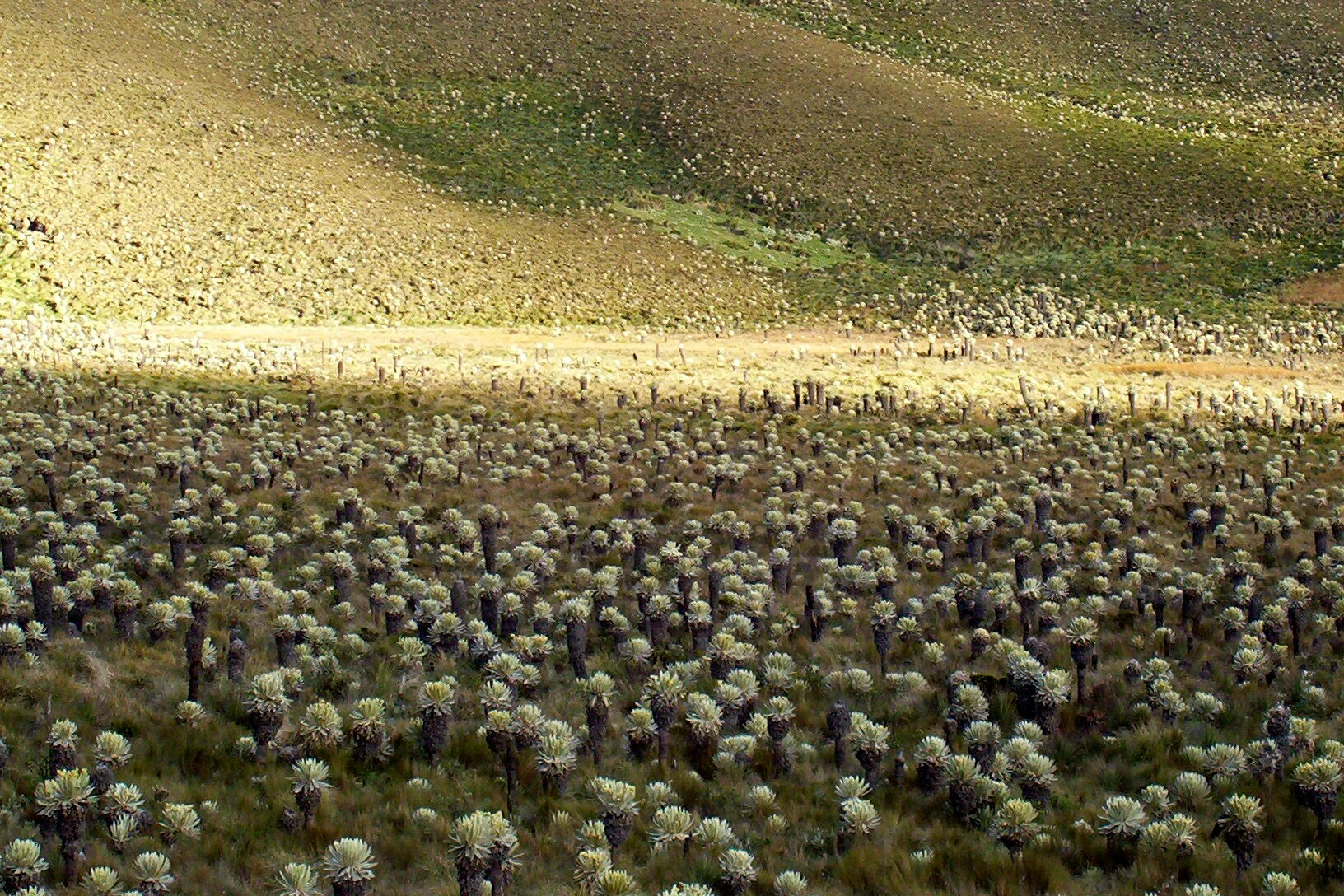
A wide view of a hilly landscape covered in a dense field of small, silver-green frailejon plants, with shadowed slopes and illuminated grass in the background.
A dense field of Espeletia pycnophylla, commonly known as frailejones, in the paramo ecosystem of the El Angel Ecological Reserve.

El Ángel Ecological Reserve history and protected-area timeline

The history of conservation at El Ángel began in 1986, when the area was declared a national conservation reserve, recognizing its extraordinary páramo landscapes and water-supply function.

In 1992, the reserve was formally established by ministerial agreement published in the official register, giving it its current status as a Reserva Ecológica. The legal creation framework, recorded as Acuerdo Interministerial No. 0415 on 5 August 1992 and published in the official register on 8 September 1992, has remained in force without subsequent modification.

The reserve has been integrated into broader national and international conservation frameworks. It was included among the fifty-six outstanding areas of the Ecuadorian System of Protected Areas, an explicit acknowledgment of its ecological importance. In 2012, its wetlands earned it designation as a Ramsar site, underscoring both the integrity of its páramo and the global value of its high-altitude water systems.

El Ángel Ecological Reserve landscape and geographic character

El Ángel's landscape is shaped by high volcanic and glacial geology. About 45 percent of the surface is composed of Pliocene volcanic deposits, while another 30 percent is formed by Quaternary glacial deposits; together, these give the reserve its rolling, often sparsely vegetated surface and its network of valleys, ridges and depressions.

The terrain includes several hills and peaks above 3,500 meters, including El Pelado, Cerro Negro, El Mirador, Chinchinal and Chiltazón. The heights form a series of scenic vantage points across the páramo, with Chiltazón standing out for condor nesting sites, traces of archaeological significance and a tall waterfall on its flanks that may be among the highest in Ecuador. Within the reserve, a series of lakes and bog systems, including Laguna Negra, Laguna Crespo, Potrerillos and the Voladero lagoons, add drama to the landscape and serve as the origin points for many rivers that supply the province of Carchi.

In the southwestern buffer area, an ancient Polylepis, or paper tree, forest clings to slopes at about 3,300 meters. This high-altitude woodland stands out from the surrounding open páramo and forms a striking patch of gnarled trees within an otherwise grassy highland matrix, with the Los Encinos station acting as a focal point for visitors exploring the area.

El Ángel Ecological Reserve ecosystems, habitats, and plant life

Around 80 percent of the reserve is covered by páramo, the high-Andean vegetation system that dominates its slopes and plateaus. The remainder is composed of high-Andean ceja andina forest, wetlands, and around lakes and creeks, fragments of evergreen montane forest reduced to patches in ravines and on steep slopes.

The páramo flora includes more than 250 plant species between 3,000 and 4,000 meters, with Asteraceae, Poaceae, Araliaceae, Bromeliaceae, Orchidaceae, Scrophulariaceae and Rosaceae among the most representative families. Lichens are abundant and serve as biological indicators of habitat maturity and conservation status. The páramo is also home to roughly 15 percent of Ecuador's endemic flora, a level of endemism that gives the reserve particular botanical significance.

The signature plant of the reserve is the frailejón (Espeletia), whose presence dominates the landscape. Other characteristic plants include pajonal grasses, chuquiragua, pumamaqui, sigse, mora and mortiño, the wild Andean berry central to Ecuador's traditional colada morada. In total, the reserve's mosaic of páramo, ceja andina forest fragments and high-altitude wetlands creates a layered ecological system shaped by elevation, water, and long-standing exposure to cold high-mountain conditions.

El Ángel Ecological Reserve wildlife and species highlights

El Ángel supports a diverse bird community, with around 320 species recorded to date. Among the most notable is the Andean condor, Vultur gryphus, a globally threatened species that nests on cliffs within the reserve. The avifauna also includes endemic species of the Central Northern Andes such as the musguerito (Iridosornis porphyrocephalus), the star-throated antbird or mottled pijuí (Margarornis stellatus) and the black-thighed puffleg (Eriocnemis derbyi).

Mammal fauna recorded in the reserve includes puma, the Andean fox (Lycalopex culpaeus), white-fronted capuchin monkeys, Hoffmann's two-toed sloth, the small red brocket deer (Mazama rufina), collared peccary, the Andean tapeti rabbit (Sylvilagus brasiliensis andinus), the white-nosed coati and the Andean weasel. These species occupy a range of habitats, from the open páramo through cloud forest fragments and humid ravines, and contribute to the ecological richness that complements the reserve's botanical importance.

El Ángel Ecological Reserve conservation status and protection priorities

El Ángel's páramo is widely recognized for its hydrological function, acting as a giant natural reservoir that sustains rivers and communities across the province of Carchi. This water-supply role is central to the reserve's conservation importance and has shaped its long-standing protection.

The reserve is registered as a Ramsar site, an international recognition of the value of its high-altitude wetlands. It is also designated as a strict nature reserve under IUCN Category Ia, the highest level of protection in the IUCN system, and is included among the fifty-six outstanding areas of Ecuador's national protected-area network.

Threats and pressures include agricultural expansion near the reserve's edge, cattle grazing in neighboring areas, deforestation in lower zones and the use of hunting trails that penetrate the protected area from surrounding communities like San Isidro, La Libertad and Tufiño. The combination of formal protection, participatory management traditions and cultural ties to the indigenous Awá territory along the western flank forms a broader conservation landscape that the reserve sits within.

El Ángel Ecological Reserve cultural meaning and human context

The reserve's western boundary adjoins the Awá indigenous territory, linking El Ángel's high-Andean páramo with the ancestral lands of the Awá people and giving the conservation landscape a strong cultural dimension.

Local folklore also surrounds the reserve's Voladero lagoons, where tradition holds that Jerónimo Tudpe, an indigenous leader, drowned himself rather than submit to the Spanish conquistadors. Such stories, along with the everyday use of the páramo's resources like the mortiño berry for colada morada during Día de los Difuntos, make the reserve an integral part of the cultural identity of Carchi.

Top sights and standout views in El Ángel Ecological Reserve

The El Ángel Ecological Reserve stands out for a unique combination of giant frailejones, water-rich páramo, and a Ramsar-recognized wetland system high in the northern Ecuadorian Andes.

Walking its trails, visitors encounter towering Espeletia plants, lakes such as Laguna Negra and Voladero, fragments of ancient Polylepis forest, and over 320 recorded bird species, including the Andean condor and several local endemics. Together, these features make the reserve a flagship site for high-Andean ecology.

Best time to visit El Ángel Ecological Reserve

The reserve has a clear, cold, high-mountain climate with two principal seasons. The dry season runs roughly from June to October, while the rainy season extends from November to May, with persistent low-intensity rain and humidity above 80 percent.

The drier months generally offer better conditions for hiking, with more stable rural roads and fewer interruptions from rain. However, the rainy season is when wetlands and lakes are fullest, and the páramo is most verdant, so visitors choosing this period should expect cloudier weather and potentially muddy or impassable local roads near the reserve. Temperatures remain cool year-round, generally around 5 to 6 degrees Celsius at higher elevations, so visitors should plan for cold highland conditions regardless of season.
Monthly climate preview

Long-term temperature and precipitation averages measured across the park coordinate

Reserva ecológica El Ángel Climate Normals and Monthly Weather Records

Historical monitoring data from 1991 to 2020 outlines measured temperature ranges and monthly precipitation patterns across representative coordinates in Reserva ecológica El Ángel. Examining the complete twelve-month statistical profile clarifies detailed seasonal variations and regional climate rhythms.
Annual mean18 °C
17 °C18 °C
Jan17°
Feb18°
Mar18°
Apr18°
May18°
Jun18°
Jul17°
Aug18°
Sep18°
Oct18°
Nov17°
Dec17°
Warmest month
May

18 °C

Coolest month
November

17.3 °C

Wettest month
April

5.3 mm/day

Driest month
August

0.9 mm/day

Park location guide

Geography guide, regional context, and park location map for El Ángel Ecological Reserve

El Ángel Ecological Reserve park geography, regions, and map view in Ecuador

Understand where El Ángel Ecological Reserve sits in Ecuador through a broader geographic reading of the surrounding landscape, nearby location context, and its mapped position within the national park landscape.

How El Ángel Ecological Reserve fits into Ecuador

Ecuador is a presidential republic located in northwestern South America, with Quito as its capital and Guayaquil as its largest city. The country spans 283,561 km² and encompasses the Galápagos Islands, a volcanic archipelago famous for unique wildlife that helped shape Darwin's theory of evolution. Ecuador is a plurinational state with Spanish as the official language, though Kichwa and Shuar are recognized for indigenous peoples.

Wider geography shaping El Ángel Ecological Reserve in Ecuador

Ecuador is located in northwestern South America along the Pacific coast. It shares borders with Colombia to the north and Peru to the east and south. The country includes the Galápagos Islands, a volcanic archipelago in the Pacific Ocean approximately 1,000 km west of the mainland. The territory encompasses diverse terrain including the Amazon rainforest in the east, the Andean highlands in the center, and coastal plains along the Pacific.

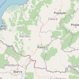
Map view of El Ángel Ecological Reserve

Use this park location map to pinpoint El Ángel Ecological Reserve in Ecuador, understand its exact geographic position, and read its mapped placement within the surrounding landscape more clearly.

Pigeon | © OpenStreetMap contributors

Location context for El Ángel Ecological Reserve

Carchi Province
Recorded earthquake history

Consult the Historical Earthquake Catalogue for Reserva ecológica El Ángel

Access a detailed archive of recorded seismic events associated with the geography of Reserva ecológica El Ángel. This MoriAtlas dataset allows you to review historical epicentres, magnitudes, and depth data for the surrounding northern Andean region, providing a clear, evidence-based look at recorded seismic history.

Reserva ecológica El Ángel Earthquake History

Catalogued events

40 events

Strongest magnitude

Magnitude 5.7

Most recent event

Apr 21, 2026

This history includes earthquakes recorded inside the park or within 50 km of its borders

Visualizing the páramo terrain, giant frailejones, and glacial wetland habitats

Reserva ecológica El Ángel Photos, Landscapes, and High-Altitude Scenery

Visual documentation captures the high-altitude volcanic terrain, towering Espeletia stands, and Ramsar wetland habitats of Reserva ecológica El Ángel. Studying these protected-area photographs reveals the dramatic topography and unique ecological character of the northern Ecuadorian Andes.

A wide view of a hilly landscape covered in a dense field of small, silver-green frailejon plants, with shadowed slopes and illuminated grass in the background.

Park atlas

Compare adjacent highland ecosystems, high-altitude wetlands, and regional protected landscapes

Other Parks Near Reserva ecológica El Ángel and Surrounding Protected Areas

Visitors exploring Reserva ecológica El Ángel can browse adjacent high-Andean reserves and protected landscapes across the northern volcanic highlands. Comparing neighboring highland habitats helps trace shared geological features, regional water sources, and connected conservation zones.
A horizontal watercolor painting showing layers of rolling green hills, a pink-toned foreground meadow, and distant hazy mountain ridgelines against a light background.
National parkImbabura
33 km away#1 closest

West

Cotacachi Cayapas National Park: A Study of Andean and Chocó Protected Geographic Landscapes

Exploring the extreme vertical transition across the northern Ecuadorian Andes

Cotacachi Cayapas National Park stands as a vital protected area, linking high-altitude páramo around Volcán Cotacachi to the lowland forests of the Chocó. The park features the iconic Laguna de Cuicocha and a dramatic range of ecosystems that define its complex terrain. This resource offers a clear look at the park's boundaries, geological features, and the distinct ecological zones that make it a central pillar of northern Ecuadorian geography.

Area
2,609.61 km²
Established
1968
IUCN
II
Visitors
50.2K annual
Nature reserveSucumbíos
52 km away#2 closest

Southeast

Reserva Ecológica Cofán-Bermejo: Mapping Amazonian and Andean Biodiversity Landscapes

Indigenous-led conservation in the Sucumbíos river headwaters.

Reserva Ecológica Cofán-Bermejo encompasses a remarkable altitudinal range from 400 to 2,200 meters, protecting intact river basins and transitional ecosystems. This nature reserve offers deep insight into the convergence of Amazonian and Andean flora, functioning as a vital refuge for threatened megafauna and rare bird populations within an indigenous-managed territory.

Area
549.47 km²
Established
2002
IUCN
Ia
Relief
Mountain
A horizontal watercolor painting depicting a purple mountain range in the background behind soft green rolling hills and a stream in the foreground.
National parkEcuador
About 69 km away#3 closest

South

Parque nacional Cayambe-Coca: Regional Geography and Protected Landscape Analysis

Equatorial volcanic peaks and Amazonian slope geography

Examine the physical geography of Parque nacional Cayambe-Coca, a protected area in Ecuador known for its extreme elevation shifts. The mapped terrain transitions from the glaciated summit of Volcán Cayambe through extensive páramo wetlands and montane cloud forests into the Amazonian foothills, providing a comprehensive case study of Andean environmental gradients.

Area
4,031.03 km²
Established
1970
IUCN
II
Relief
Mountain
Watercolor illustration of a mountain range with a lake in the foreground, green fields, and a colorful sky
Protected areaColombia
About 76 km away#4 closest

Northeast

Galeras Protected Area: Exploring Colombia's Mapped Natural Landscapes

Discover the geography and protected terrain of Galeras.

The Galeras protected area in Colombia offers a distinct opportunity for geographic exploration, focusing on its defined boundaries and the natural landscape it encompasses. This resource details the park's setting within the Colombian geography, providing a map-centric view of its protected status. Understanding Galeras contributes to a broader appreciation of protected lands across South America and their unique terrain.

Relief
Mountain
Climate
Alpine
Access
Highly restricted
Watercolor illustration showing a panoramic view of a wide valley with green hills, a small stream, and forested clusters, rendered in a light and airy style.
Nature reservePichincha
About 84 km away#5 closest

Southwest

Reserva Geobotánica Pululahua: Protected Volcanic Caldera and Highland Ecosystems

A distinct geobotanical reserve in the Pichincha region of the Ecuadorian Andes.

Reserva Geobotánica Pululahua is a protected natural area centered on a massive, 12-kilometer-wide volcanic caldera. Its landscape features three prominent lava domes and a rare altitudinal gradient of vegetation, spanning from semi-dry mountain shrubland to dense cloud forest. This reserve serves as a critical study of volcanic geology and human-landscape interaction in the high Andes, offering a concentrated look at Ecuador's vertical ecological zonation.

Area
34.417 km²
Established
1966
Relief
Mountain
Climate
Subtropical
Watercolor painting of a lake with green hills and trees in the background
Protected areaNariño
About 89 km away#6 closest

Northeast

La Corota Island Flora Sanctuary: A Unique Protected Area within Colombia's Nariño Region

Explore its Andean cloud forest landscape and mapped island geography.

La Corota Island Flora Sanctuary is a critical protected area in Nariño, Colombia, celebrated for its distinctive status as the country's only lake island ecosystem supporting old-growth Andean cloud forest. This compact sanctuary provides a unique landscape context, safeguarding endemic plant species and diverse birdlife within its mapped boundaries. Its presence within Laguna de la Cocha highlights a special convergence of wetland and forest geography, offering insights for atlas exploration of protected lands.

Area
0.152 km²
Established
1977
IUCN
II
Visitors
28K annual
National parkEcuador
103 km away#7 closest

South

Sumaco Napo-Galeras National Park: Ecuador's Volcanic National Park Landscape

Explore protected areas and biodiversity in the Andean-Amazon transition.

Sumaco Napo-Galeras National Park protects a dramatic volcanic landscape in Ecuador, showcasing a significant elevation gradient that supports diverse cloud forest and Amazonian rainforest habitats. This national park is recognized for its endemic species and rich avifauna, offering a compelling case study for understanding protected land geography and ecological transitions within South America.

Area
2,067.49 km²
Established
1994
IUCN
II
Relief
Mountain
Nature reserveEsmeraldas
106 km away#8 closest

Northwest

Reserva ecológica Manglares Cayapas-Mataje: Mapped Coastal Wetland and Protected Landscape

A vast estuarine and mangrove refuge in the Esmeraldas province of Ecuador.

The Reserva ecológica Manglares Cayapas-Mataje spans over 49,000 hectares of diverse coastal terrain, including tidal estuaries, guandales, and tropical lowland forests. As a Ramsar-recognized wetland, this reserve preserves critical connectivity between riverine basins and the Pacific Ocean, acting as a vital geographic anchor for Chocó endemic species and complex aquatic habitats within the Esmeraldas region.

Area
490.71 km²
Established
1995
Relief
Lowland
Climate
Tropical

Common questions about visiting, size, designation, and location context for El Ángel Ecological Reserve

El Ángel Ecological Reserve FAQs for park facts, access, geography, and protected area context

Find quick answers about El Ángel Ecological Reserve, including protected-area facts, park geography, trail and visitor context, and how the park fits into its surrounding country and regional landscape.
MoriAtlas Explorer

Continue Your Protected Areas Search Across the Global Atlas

Deepen your exploration by continuing the structured search for national parks and protected areas worldwide. Utilize the comprehensive filtering capabilities to compare different conservation landscapes and refine your understanding of global park geography. Discover more about the distribution and characteristics of protected natural areas.

Global natural geography