Mori Atlas logo
Nature reserveReserva ecológica Manglares Cayapas-Mataje

A coastal atlas of the most significant mangrove wetland system along the South Pacific shoreline.

Reserva ecológica Manglares Cayapas-Mataje: Mapped Estuarine Landscape and Protected Geography

(Reserva Ecológica Manglares Cayapas-Mataje)

Reserva ecológica Manglares Cayapas-Mataje represents an extensive protected complex of mangrove forests, tidal channels, and tropical floodable terrain located on the northwestern coast of Ecuador. This vital conservation landscape encompasses the lower basins of the Cayapas and Mataje rivers, where complex estuarine ecosystems and freshwater lagoons define the regional geography near the Colombian border. The protected area serves as a key stronghold for Chocó biogeographic diversity, offering a unique mosaic of marine and terrestrial habitats.

mangrovesestuarine ecosystemRamsar wetlandPacific coastChocó biogeographytropical rainforest

Reserva ecológica Manglares Cayapas-Mataje

Nature reserve

Park overview

Structured park overview, official facts, and landscape profile for Manglares Cayapas-Mataje Ecological Reserve

Manglares Cayapas-Mataje Ecological Reserve park facts, protected area profile, and essential visitor context

Review the core facts for Manglares Cayapas-Mataje Ecological Reserve, including designation, size, terrain, visitor scale, habitats, and operating context in one park-focused overview.

About Manglares Cayapas-Mataje Ecological Reserve

The Manglares Cayapas-Mataje Ecological Reserve is one of Ecuador's defining coastal protected areas, sitting where the country's northwestern Esmeraldas coast meets the Pacific Ocean and the Colombian border. The reserve is centered on the estuarine belt where the Cayapas and Mataje rivers empty into the ocean, a landscape defined by vast mangrove forests cut by tidal channels, interspersed with seasonally flooded lowland forest and backed by tropical rainforest that climbs toward the Andean foothills.

The reserve's ecological importance lies in the way it stitches together multiple habitat types into a single functioning coastal system. Mangroves dominate the tidal zone, while guandales, or floodable lowland forests, occupy the transition between salt- and freshwater environments. Inland, tierra firme tropical rainforest covers areas that have not been converted to agriculture. Freshwater systems, including Laguna de la Ciudad, represent a third important component with floating and emergent aquatic vegetation, surrounding small-scale agriculture, and seasonal flood dynamics.

Beyond its ecological value, the reserve has strong cultural dimensions. The mangrove landscape has long been inhabited by Afro-Esmeraldeño communities, twenty-six of which live within the reserve boundaries, with additional communities such as Valdez and Ancón situated just outside. Traditional livelihoods continue to rely on the mangroves for fishing, crabbing, and shellfish harvest, while the surrounding lowlands host small-scale agriculture, cattle pasture, and larger commercial plantations of African palm and banana. As a Ramsar site since 2003, the reserve stands as both a hemispheric conservation priority and a working coastal landscape where ecological and cultural heritage remain closely intertwined.

Quick facts and research context for Manglares Cayapas-Mataje Ecological Reserve

The Manglares Cayapas-Mataje Ecological Reserve is located in the cantons of San Lorenzo and Eloy Alfaro in the northwestern part of Esmeraldas province, Ecuador, bordering Colombia along the Mataje River. Established on 26 October 1995 and administered by Ecuador's Ministry of the Environment, it spans over 49,000 hectares of mangrove, estuarine, floodplain, and tropical lowland forest habitats. The reserve was declared a Ramsar Wetland of International Importance in 2003 and lies within the Chocó biogeographic region of the Neotropics.

Protection and recognition

Documented protection history and international Ramsar recognition records

Reserva ecológica Manglares Cayapas-Mataje Protection Status and Recognition

Reserva ecológica Manglares Cayapas-Mataje holds documented protection status established in 2003 with mixed management scope across the protected area. Official records detail international recognition sources including a designated Ramsar wetland listing for geographic evaluation.

International recognition

Protection details

Protection scope
Mixed
Designated year
2003
Transboundary protection
No
Park context

Deeper park guide and search-rich context for Manglares Cayapas-Mataje Ecological Reserve

Manglares Cayapas-Mataje Ecological Reserve history, landscape, wildlife, and travel context

Explore Manglares Cayapas-Mataje Ecological Reserve through its history, landscape character, ecosystems, wildlife, conservation priorities, cultural context, and seasonal travel timing in a structured park guide built for atlas discovery and search intent.

Why Manglares Cayapas-Mataje Ecological Reserve stands out

The reserve is best known for hosting the largest and most intact estuarine mangrove system of the South Pacific, a Ramsar-recognized wetland of more than 49,000 hectares where mangrove forests, tidal channels, and freshwater lagoons converge with the lower reaches of the Cayapas and Mataje rivers. It is also distinguished by its Chocó biogeographic richness, with notable levels of regional endemism in both flora and avifauna, and by the coexistence of mangrove ecosystems with the cultural heritage of Afro-Esmeraldeño coastal communities.

Manglares Cayapas-Mataje Ecological Reserve history and protected-area timeline

The Manglares Cayapas-Mataje Ecological Reserve was formally established on 26 October 1995 through Interministerial Agreement number 052, published in the Official Registry number 822 on 15 November 1995. The creation of the reserve came in response to growing recognition of the ecological value of the mangrove and estuarine systems along the Esmeraldas coast and the need to safeguard them from expanding agricultural frontiers, particularly African palm and banana plantations, cattle ranching, and logging.

The reserve's legal framework was refined over subsequent years through multiple modifications recorded in Ecuador's Official Registry between 1996 and 2004, adjusting boundaries, administrative categories, and management provisions to better reflect the ecological complexity of the area and the presence of established communities within and around the mangrove zone.

A defining moment in the reserve's international profile came in 2003, when it was designated as a Ramsar Wetland of International Importance, confirming its status as the largest and best-conserved estuarine mangrove system on the South Pacific coast and bringing it into the global network of protected wetlands.

Manglares Cayapas-Mataje Ecological Reserve landscape and geographic character

The reserve's landscape is a mosaic of coastal, estuarine, and lowland tropical environments along the northwestern Ecuadorian Pacific coast. The most visually dominant feature is the extensive mangrove forest belt that lines the tidal zone, cut by a network of esteros and tidal channels where the Cayapas and Mataje rivers meet the ocean. These mangroves give way inland to guandales, seasonally flooded lowland forests characteristic of this part of the Chocó coast, and farther upslope to humid tropical rainforest on tierra firme.

Freshwater elements add further landscape diversity. Shallow lagoons and slow-moving river corridors support floating and emergent aquatic vegetation, while floodplains around communities such as Valdez and Ancón reflect centuries of human interaction with a dynamic and seasonally changing coastal terrain. In the higher zones of the reserve, the terrain transitions more gradually toward the forested foothills that connect the coastal plain to the Andean ranges to the east.

The overall impression is one of an exceptionally watery, low-lying landscape shaped by tides, rainfall, and river flow, where the boundaries between sea, estuary, forest, and freshwater lagoon are constantly shifting. Outside the reserve's protected core, the surrounding lowlands have been heavily converted to cattle pasture and large-scale African palm and banana plantations, creating sharp contrasts between the conserved mangrove interior and the agricultural matrix around it.

Manglares Cayapas-Mataje Ecological Reserve ecosystems, habitats, and plant life

The Manglares Cayapas-Mataje Ecological Reserve sits within the Chocó biogeographic region, a globally recognized hotspot of biodiversity that extends along the Pacific coast from southern Panama through Colombia into northwestern Ecuador. The reserve's ecosystems reflect this regional identity, combining mangrove, estuarine, freshwater, floodable, and tierra firme tropical forest habitats in close proximity.

The vegetation profile is unusually varied for a coastal protected area. The mangrove forests themselves are composed of species adapted to tidal saltwater, while the guandales intermix with mangrove influenced soils to create flood-tolerant lowland forest. In freshwater environments such as Laguna de la Ciudad, typical aquatic plants such as Nymphaea glandulifera, Azolla carolina, Ceratophyllum llerenae, and Thalia geniculata form rich floating and emergent communities. The broader Chocó flora contributes notable regional endemism, with roughly twenty percent of plant species in northwestern Esmeraldas being endemic to the region.

Ecologically, the reserve functions as a critical interface between marine and terrestrial systems. Mangrove productivity supports abundant zooplankton communities, which in turn sustain rich populations of mollusks, crustaceans, fish, and the larger predators that depend on them. The combination of salinity gradients, freshwater inputs from the Cayapas and Mataje rivers, and intact forest cover produces a layered estuarine system of considerable ecological integrity, recognized internationally as a Ramsar site for its conservation value.

Manglares Cayapas-Mataje Ecological Reserve wildlife and species highlights

The reserve supports a wide array of wildlife thanks to the convergence of mangrove, estuarine, freshwater, and forest habitats. Marine and freshwater fauna together account for at least sixty-six recorded species, reflecting the productivity of the mangrove ecosystem and its role as a nursery and feeding ground. Common groups include mollusks, crustaceans, and a diversity of fish species that underpin both the natural food web and the traditional fisheries of local communities.

Reptiles, mammals, and marine mammals add a higher trophic layer to this system. The American crocodile (Crocodylus acutus) inhabits the mangrove corridors, while mammals such as the woolly opossum (Caluromys derbianus), the water opossum (Chironectes minimus), the bush dog (Speothos venaticus), the neotropical river otter (Lontra longicaudis), the naked-tailed armadillo (Cabassous centralis), and the jaguar (Panthera onca) range through adjacent forests and waterways. Bottlenose dolphins (Tursiops truncatus) are also recorded in the reserve's coastal waters.

The reserve is particularly important for birds, although its full avian diversity has not been precisely documented. It hosts significant populations of globally threatened and Chocó-endemic species, including the Baudó guan (Penelope ortoni), the rufous-headed chachalaca (Ortalis erythroptera), the brown wood-rail (Aramides wolfi), the ochre attila (Attila torridus), and the scarlet-breasted dacnis (Dacnis berlepschi). This combination of mangrove, forest, and freshwater habitats makes the reserve an exceptional site for birdwatching and for the conservation of Chocó-restricted avifauna.

Manglares Cayapas-Mataje Ecological Reserve conservation status and protection priorities

The reserve's central conservation importance lies in protecting the largest and best-conserved estuarine mangrove system of the South Pacific coast, an exceptionally rare type of coastal ecosystem in the region. As a Ramsar Wetland of International Importance since 2003, it is formally recognized for its ecological value, its role in supporting migratory and resident waterbirds, and its intact hydrological and forest dynamics.

Beyond its mangrove core, the reserve safeguards a remarkably complete vertical profile of coastal habitats, from tidal flats and estuaries through guandales and tierra firme tropical forest to freshwater lagoons. This habitat diversity supports high regional endemism and provides refuge for threatened species such as the jaguar, the American crocodile, and several Chocó-endemic birds. The reserve also contributes to climate resilience, shoreline protection, and carbon storage through its extensive mangrove cover.

However, the conservation outlook is mixed. The reserve's surroundings have been heavily transformed by cattle ranching and large-scale African palm and banana plantations, putting pressure on forest edges and creating edge effects on the protected area. Continued management attention is required to maintain the integrity of the mangrove interior, defend water quality, and support sustainable livelihoods for the Afro-Esmeraldeño communities whose culture is closely tied to the mangrove ecosystem.

Manglares Cayapas-Mataje Ecological Reserve cultural meaning and human context

The mangrove landscape of the Cayapas-Mataje reserve is inseparable from the cultural identity of the Afro-Esmeraldeño communities that have lived along this coast for generations. Twenty-six Afro-Esmeraldeño communities live within the reserve boundaries, while additional settlements, including Valdez and Ancón, are located just outside. These communities maintain traditional livelihoods linked to the mangrove estuary, including fishing, crabbing, harvesting shellfish, and small-scale agriculture on floodplains and around freshwater lagoons such as Laguna de la Ciudad.

Local agricultural patterns reflect the ecological setting: subsistence crops of maize, cassava, banana, plantain, citrus, babaco, and cacao grow in small plots alongside cattle pasture, while larger commercial plantations of African palm and banana dominate the surrounding lowlands. The reserve therefore represents not only a natural landscape but a cultural landscape shaped by long-standing Afro-Esmeraldeño presence and adaptation to the rhythms of tides, rivers, and seasonal flooding along the Chocó coast.

Top sights and standout views in Manglares Cayapas-Mataje Ecological Reserve

The reserve's standout qualities include the largest and best-conserved estuarine mangrove system on the South Pacific coast, an internationally recognized Ramsar wetland, and an exceptional combination of mangrove, floodplain, freshwater lagoon, and tropical lowland forest habitats. Its position within the Chocó biogeographic region gives it unusually high levels of regional endemism in both plants and birds, while the presence of threatened species such as the American crocodile, jaguar, and several Chocó-endemic birds underscores its conservation significance.

Best time to visit Manglares Cayapas-Mataje Ecological Reserve

The coastal climate of northwestern Esmeraldas is humid and warm year-round, with a wetter season typically running from roughly December through May and a relatively drier period from June to November. The drier months generally offer calmer conditions for boat-based exploration of the mangrove channels and easier wildlife viewing, while the wetter months bring higher water levels, more dynamic tidal exchange, and lush conditions in the surrounding forests. Birdwatching can be rewarding across much of the year, particularly for residents, and the mangrove landscape itself remains green and active in all seasons.
Monthly climate preview

Long-term representative point measurements of annual temperature and precipitation rhythm

Reserva ecológica Manglares Cayapas-Mataje Climate Normals and Weather by Month

Representative coordinates record consistent monthly average temperatures alongside shifting precipitation totals across the protected landscape. Examining the full twelve-month profile provides deeper analytical context for long-term regional climate patterns.
Annual mean26 °C
25 °C26 °C
Jan26°
Feb26°
Mar26°
Apr26°
May26°
Jun26°
Jul26°
Aug26°
Sep26°
Oct26°
Nov26°
Dec25°
Warmest month
August

26.2 °C

Coolest month
December

25.5 °C

Wettest month
April

5.3 mm/day

Driest month
August

0.9 mm/day

Park location guide

Geography guide, regional context, and park location map for Manglares Cayapas-Mataje Ecological Reserve

Manglares Cayapas-Mataje Ecological Reserve park geography, regions, and map view in Ecuador

Understand where Manglares Cayapas-Mataje Ecological Reserve sits in Ecuador through a broader geographic reading of the surrounding landscape, nearby location context, and its mapped position within the national park landscape.

How Manglares Cayapas-Mataje Ecological Reserve fits into Ecuador

Ecuador is a presidential republic located in northwestern South America, with Quito as its capital and Guayaquil as its largest city. The country spans 283,561 km² and encompasses the Galápagos Islands, a volcanic archipelago famous for unique wildlife that helped shape Darwin's theory of evolution. Ecuador is a plurinational state with Spanish as the official language, though Kichwa and Shuar are recognized for indigenous peoples.

Wider geography shaping Manglares Cayapas-Mataje Ecological Reserve in Ecuador

Ecuador is located in northwestern South America along the Pacific coast. It shares borders with Colombia to the north and Peru to the east and south. The country includes the Galápagos Islands, a volcanic archipelago in the Pacific Ocean approximately 1,000 km west of the mainland. The territory encompasses diverse terrain including the Amazon rainforest in the east, the Andean highlands in the center, and coastal plains along the Pacific.

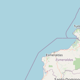
Map view of Manglares Cayapas-Mataje Ecological Reserve

Use this park location map to pinpoint Manglares Cayapas-Mataje Ecological Reserve in Ecuador, understand its exact geographic position, and read its mapped placement within the surrounding landscape more clearly.

Pigeon | © OpenStreetMap contributors

Location context for Manglares Cayapas-Mataje Ecological Reserve

Esmeraldas
Recorded earthquake history

Explore the Historical Earthquake Records for Reserva ecológica Manglares Cayapas-Mataje

Review documented seismic events and epicentre data associated with the vicinity of Reserva ecológica Manglares Cayapas-Mataje. This MoriAtlas catalogue provides access to historical earthquake records to support regional geographic discovery through transparent, data-driven insights.

Reserva ecológica Manglares Cayapas-Mataje Earthquake History

Catalogued events

32 events

Strongest magnitude

Magnitude 5.7

Most recent event

Oct 22, 2024

This history includes earthquakes recorded inside the park or within 50 km of its borders

Park atlas

Compare adjacent coastal ecosystems, estuarine wetlands, and connected Chocó conservation areas

Other Parks Near Reserva ecológica Manglares Cayapas-Mataje and Regional Protected Landscapes

Browsing other parks near Reserva ecológica Manglares Cayapas-Mataje reveals the broader coastal and estuarine conservation network across northwestern Ecuador. Analyzing these protected landscapes provides valuable regional context on tidal wetlands, lowland rainforests, and tropical biodiversity corridors.
A horizontal watercolor painting showing layers of rolling green hills, a pink-toned foreground meadow, and distant hazy mountain ridgelines against a light background.
National parkImbabura
41 km away#1 closest

South

Cotacachi Cayapas National Park: A Study of Andean and Chocó Protected Geographic Landscapes

Exploring the extreme vertical transition across the northern Ecuadorian Andes

Cotacachi Cayapas National Park stands as a vital protected area, linking high-altitude páramo around Volcán Cotacachi to the lowland forests of the Chocó. The park features the iconic Laguna de Cuicocha and a dramatic range of ecosystems that define its complex terrain. This resource offers a clear look at the park's boundaries, geological features, and the distinct ecological zones that make it a central pillar of northern Ecuadorian geography.

Area
2,609.61 km²
Established
1968
IUCN
II
Visitors
50.2K annual
Nature reserveEsmeraldas
99 km away#2 closest

Southwest

Reserva Ecológica Mache-Chindul: Coastal Mountain and Tropical Forest Protected Geography

Mapping the biodiversity of Esmeraldas provincial wilderness

Spanning over 119,000 hectares, Reserva Ecológica Mache-Chindul stands as a primary ecological shield against landscape degradation in coastal Ecuador. This site preserves rare mature forest mosaics, from dense Chocó lowland rainforest to misty high-altitude ridges. Gain geographic insight into this vital wilderness area through its distinct watershed basins and protected forest corridors.

Area
1,191.72 km²
Established
1996
IUCN
Ia
Relief
Mountain
Nature reserveCarchi Province
106 km away#3 closest

Southeast

Reserva ecológica El Ángel: High-Andean Protected Landscape and Geography Map

Exploring páramo ecosystems in Carchi Province, Ecuador

Reserva ecológica El Ángel is a crucial conservation area in the northern Andes, defined by its high-altitude páramo, volcanic geology, and extensive wetland network. It serves as a vital hydrological heart for Carchi Province, supporting diverse highland vegetation including dense stands of giant frailejón and ancient Polylepis forests across a dramatic, glacially-sculpted terrain.

Area
165.41 km²
Established
1992
IUCN
Ia
Relief
Mountain
Marine protected areaEsmeraldas
About 131 km away#4 closest

Southwest

Reserva marina Galera San Francisco: Geographic Overview of the Marine Protected Area

Coastal cliffs, marine habitats, and regional landscape context in Esmeraldas

Reserva marina Galera San Francisco offers a unique look at the integration of terrestrial and oceanic ecosystems. From the cliff-lined coast of Esmeraldas to the depths of the Pacific, this protected area features coral zones, complex estuary systems, and vital nesting grounds. Examine the spatial distribution of these marine features and the geological formations that shape this coastal boundary through our structured geographic atlas.

Area
546.886 km²
Established
2008
IUCN
VI
Relief
Mixed relief
Watercolor illustration showing a panoramic view of a wide valley with green hills, a small stream, and forested clusters, rendered in a light and airy style.
Nature reservePichincha
About 133 km away#5 closest

South

Reserva Geobotánica Pululahua: Protected Volcanic Caldera and Highland Ecosystems

A distinct geobotanical reserve in the Pichincha region of the Ecuadorian Andes.

Reserva Geobotánica Pululahua is a protected natural area centered on a massive, 12-kilometer-wide volcanic caldera. Its landscape features three prominent lava domes and a rare altitudinal gradient of vegetation, spanning from semi-dry mountain shrubland to dense cloud forest. This reserve serves as a critical study of volcanic geology and human-landscape interaction in the high Andes, offering a concentrated look at Ecuador's vertical ecological zonation.

Area
34.417 km²
Established
1966
Relief
Mountain
Climate
Subtropical
Wildlife reserveEsmeraldas
About 157 km away#6 closest

Southwest

Refugio de Vida Silvestre Manglares Estuario Río Muisne Coastal Wildlife Reserve

Esmeraldas, Ecuador protected estuarine landscape

Discover the complex geography of Refugio de Vida Silvestre Manglares Estuario Río Muisne, a vital wildlife refuge protecting all six native mangrove species. This area spans a rich transition of marine and brackish waters, tidal flats, and forest stands that define the northwestern Pacific coastline of Ecuador.

Area
922.46 km²
Established
2003
Relief
Lowland
Access
Access unknown
Watercolor illustration of a mountain range with a lake in the foreground, green fields, and a colorful sky
Protected areaColombia
About 158 km away#7 closest

East

Galeras Protected Area: Exploring Colombia's Mapped Natural Landscapes

Discover the geography and protected terrain of Galeras.

The Galeras protected area in Colombia offers a distinct opportunity for geographic exploration, focusing on its defined boundaries and the natural landscape it encompasses. This resource details the park's setting within the Colombian geography, providing a map-centric view of its protected status. Understanding Galeras contributes to a broader appreciation of protected lands across South America and their unique terrain.

Relief
Mountain
Climate
Alpine
Access
Highly restricted
A wide watercolor illustration showing a misty landscape with green trees in the midground and faint mountain peaks in the background.
Nature reserveEcuador
166 km away#8 closest

South

Reserva Ecológica Los Illinizas: Geographic Atlas and Andean Protected Nature Reserve

Volcanic terrain and cloud forest ecosystems in central Ecuador

Spanning across the provinces of Cotopaxi, Pichincha, and Santo Domingo de los Tsáchilas, Reserva Ecológica Los Illinizas preserves a significant vertical gradient of Andean ecosystems. The reserve protects the western flanks of the Illiniza volcanoes, Quilotoa, and El Corazón, offering a detailed look at high-altitude biodiversity and the transition from rugged mountain peaks to lush western cloud forests.

Area
1,342.33 km²
Established
1996
IUCN
Ia
Relief
Mountain

Common questions about visiting, size, designation, and location context for Manglares Cayapas-Mataje Ecological Reserve

Manglares Cayapas-Mataje Ecological Reserve FAQs for park facts, access, geography, and protected area context

Find quick answers about Manglares Cayapas-Mataje Ecological Reserve, including protected-area facts, park geography, trail and visitor context, and how the park fits into its surrounding country and regional landscape.
MoriAtlas Explorer

Continue Your Protected Areas Search Across the Global Atlas

Deepen your exploration by continuing the structured search for national parks and protected areas worldwide. Utilize the comprehensive filtering capabilities to compare different conservation landscapes and refine your understanding of global park geography. Discover more about the distribution and characteristics of protected natural areas.

Global natural geography