


Mori Atlas logo
Marine protected areaReserva Marina El Pelado

Explore the oceanic convergence zone, volcanic islet topography, and coastal reef architecture

Reserva Marina El Pelado: Mapping the Marine Protected Landscapes and Reef Systems of Santa Elena

Reserva Marina El Pelado stands as a significant marine protected area along the Ecuadorian coast, defined by the meeting of the warm Panama Baya waters and the cold Humboldt Current. This geographic exploration covers the reserve's thirteen submarine shoals, mangrove zones, and rocky reef habitats that support a high diversity of marine organisms. The area acts as a crucial oceanographic front, providing a unique environment for the study of sessile invertebrates and coastal biological zonation.

marine reservetropical eastern pacificrocky reefoctocoral habitatmangrove ecosystemseabird nesting
A flat-style digital illustration of a coastal landscape at sunrise, featuring steep cliffs, a rocky sea arch islet in the center, and surrounding vegetation.

Reserva Marina El Pelado

Marine protected area

Park overview

Structured park overview, official facts, and landscape profile for Reserva Marina El Pelado

Reserva Marina El Pelado park facts, protected area profile, and essential visitor context

Review the core facts for Reserva Marina El Pelado, including designation, size, terrain, visitor scale, habitats, and operating context in one park-focused overview.

About Reserva Marina El Pelado

Reserva Marina El Pelado, commonly abbreviated as REMAPE, is a coastal marine reserve on Ecuador's central-western Pacific shore in Santa Elena Province. Created in 2012, the reserve integrates multiple ecosystems into a single management unit: an extensive rocky reef with thirteen submarine shoals and associated coral patches, the small rocky islet El Pelado, mangrove forests around Palmar, and the surrounding coastal waters used by several fishing and tourism communities.

From an oceanographic standpoint, REMAPE occupies one of the most interesting positions along the Tropical Eastern Pacific. The reserve lies at the southern end of the Guayaquil ecoregion, right where the equatorial front forms. Here the warm, lower-salinity waters arriving from the north encounter the colder, nutrient-rich waters of the Humboldt Current, whose productivity is driven by coastal upwelling. From December to May the Humboldt Current weakens, allowing warm equatorial waters to advance southward along Ecuador's coast, while the Intertropical Convergence Zone shifts toward Ecuadorian latitudes. The result is a highly variable marine environment that periodically shifts between warm-water and cool-water conditions.

These fluctuations are amplified by the El Niño-Southern Oscillation cycle, which occurs roughly every four to five years and dramatically alters temperature and salinity. Because many of the reef organisms in the reserve are sessile invertebrates that cannot move when conditions change, the entire reef community is shaped by exposure to both warm- and cold-water extremes. This has given REMAPE an outsized scientific importance: it serves as a natural laboratory for biogeography, functional biodiversity, climate change research, and the study of biodiscovery from marine invertebrates, topics actively pursued at the nearby CENAIM research center.

Quick facts and research context for Reserva Marina El Pelado

Established on 24 August 2012 through Interministerial Agreement No. 118, Reserva Marina El Pelado covers roughly 131.55 square kilometers within Ecuador's national system of protected areas. It lies along the coast of Santa Elena Province, with the nearest city being Santa Elena itself, and belongs to the southernmost end of the Guayaquil ecoregion in the Tropical Eastern Pacific.

The reserve integrates thirteen submarine rocky shoals with coral patches, the islet El Pelado, mangrove areas, and four coastal localities (Palmar, Ayangue, San Pedro, and Valdivia). It is classified as an IUCN Category VI protected area, recognizing it as a managed-resource reserve where conservation coexists with regulated fishing, aquaculture, tourism, and scientific research.

Protection and recognition

Examine the documented marine protection scope and governing recognition records.

Reserva Marina El Pelado Protection Status and Marine Protected Area Designation

Reserva Marina El Pelado protection status data compiles the official marine boundaries and administrative designations for this protected area. Analysis of the recorded governance framework provides a clear baseline for understanding regional conservation commitments.

Protection details

Protection scope
Marine
Transboundary protection
No
Park context

Deeper park guide and search-rich context for Reserva Marina El Pelado

Reserva Marina El Pelado history, landscape, wildlife, and travel context

Explore Reserva Marina El Pelado through its history, landscape character, ecosystems, wildlife, conservation priorities, cultural context, and seasonal travel timing in a structured park guide built for atlas discovery and search intent.

Why Reserva Marina El Pelado stands out

Reserva Marina El Pelado is best known for sitting at the equatorial front of the Tropical Eastern Pacific, a dynamic oceanographic boundary where warm Panama Baya waters meet the cold, upwelling-influenced Humboldt Current. This mixing zone creates unusual ecological conditions that bring together species typical of both warm and cold tropical Pacific waters. The reserve is also distinguished by its combination of habitats in a compact coastal area: a rocky reef with thirteen submarine shoals and octocoral patches, mangrove systems, and the small volcanic-looking islet of El Pelado, which supports a nesting colony of blue-footed boobies and a sea lion haul-out. These features have made the reserve an important natural laboratory for marine biology, taxonomy, climate-related research, and biodiscovery of bioactive compounds from sessile invertebrates.
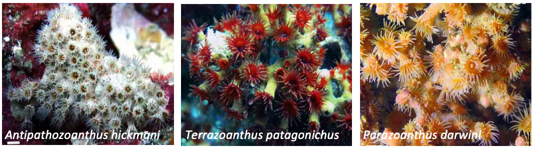
A three-panel composite image showing close-up underwater photographs of three different types of zoanthids, each labeled with its scientific name.
A collection of zoanthid species found in the Reserva Marina El Pelado, including Antipathozoanthus hickmani, Terrazoanthus patagonichus, and Parazoanthus darwini.

Reserva Marina El Pelado history and protected-area timeline

Reserva Marina El Pelado was formally created on 24 August 2012 through Interministerial Agreement No. 118, registered in Ecuador's Official Registry. The reserve was incorporated into Ecuador's national system of protected areas as a Reserva Marina, a category that reflects its emphasis on conserving marine ecosystems while still allowing regulated resource use.

The reserve's development has been closely tied to the presence of the Centro Ecuatoriano de Acuicultura e Investigaciones Marinas (CENAIM) of the Escuela Superior Politécnica del Litoral (ESPOL), located in the coastal community of San Pedro. CENAIM's research activities, together with programs by MAGAP and SENESCYT, have shaped much of the early scientific work in the reserve, including laboratory reproduction programs for the heavily harvested Spondylus limbatus and studies on the invasive octocoral predator Carijoa riisei.

Reserva Marina El Pelado landscape and geographic character

The seascape of Reserva Marina El Pelado is shaped by the offshore rocky reef system dominated by thirteen submarine shoals (locally called bajos) surrounding the small rocky islet of El Pelado. Four prominent rocky mounds rise from the seafloor, reaching depths of around 25 meters. The western margins of these mounds drop off more steeply, while the eastern flanks slope gently into calmer, more sheltered waters that remain protected for much of the year.

These depth and slope differences create distinct bands of biological zonation. The most conspicuous substrate-habitat zones include a Balanus barnacle zone, a filamentous algal zone, octocoral forest zones, sandy zones, and, on the leeward side of the islet, irregular patches of Pocillopora coral. Along the rocky points of the adjacent coastline, the Balanus zone and zoantharian zones stand out as dominant intertidal and shallow subtidal habitats.
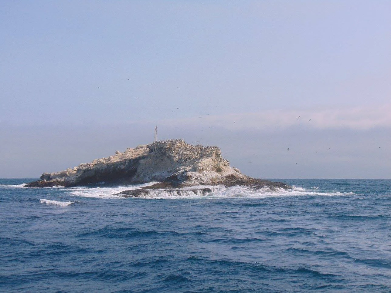
A small, rocky island surrounded by ocean waves under a hazy sky.
The El Pelado islet, a key feature of the Reserva Marina El Pelado in Ecuador.

Reserva Marina El Pelado ecosystems, habitats, and plant life

Ecologically, REMAPE is defined by the interplay between tropical Pacific reef habitats, mangrove forests, and the open ocean conditions of the equatorial front. The rocky reef is colonized by diverse sponges, cnidarians, octocorals, zoantharians, and reef-associated invertebrates, while the mangrove zones and coastal coves support their own communities of crustaceans, mollusks, and juvenile fish. The combination of warm-water and cold-water influences, intensified by El Niño events, produces a reef community adapted to fluctuating temperatures and salinities.

Some of the highest species diversity within the reserve has been documented at sites such as La Cabeza del Viejo, Zona Protegida, La Pared, and El Bajo Cuarenta. Surveys have recorded at least seventeen species of octocorals from the families Plexauridae, Gorgoniidae, and Clavularidae, together with a rich array of sponges and cnidarians, including species such as Callyspongia aff. californica, Cliona aff. euryphylle, and the newly described demosponge Tedania (Tedania) ecuadoriensis.
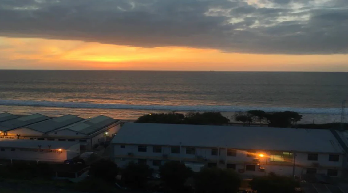
A wide angle sunset view over the ocean with buildings visible in the foreground along the coast.
Sunset view over the Pacific Ocean from the coast, near the area of the Reserva Marina El Pelado.

Reserva Marina El Pelado wildlife and species highlights

Wildlife in REMAPE reflects both the marine and the island character of the reserve. The islet El Pelado functions as a nesting refuge for marine birds and supports one of the reserve's most visible animal attractions: a haul-out of South American sea lions (Otaria flavescens). Among the seabirds, blue-footed boobies (Sula nebouxii) are particularly notable for their conspicuous nesting colonies.

The surrounding waters host diverse reef fish communities, with families such as Serranidae and Pomacentridae among the most representative. The broader coastal area is used seasonally by humpback whales (Megaptera novaeangliae), which pass through from June to September and are regularly observed from the town of Ayangue. In addition, sites within the reserve such as the Parque Marino Valdivia provide refuge for sea turtles, additional pinniped groups, and penguins, and the area also functions as a rescue center for injured or stranded marine animals.

Reserva Marina El Pelado conservation status and protection priorities

Reserva Marina El Pelado holds clear conservation significance as a representative example of Tropical Eastern Pacific reef and mangrove ecosystems within Ecuador's national protected-area system. Its IUCN Category VI status recognizes that conservation objectives are pursued alongside regulated human activities, including sustainable fishing, aquaculture, tourism, and research.

The reserve also plays a growing role in applied conservation science. Programs led by CENAIM-ESPOL together with MAGAP have focused on laboratory reproduction of Spondylus limbatus for repopulation purposes, while SENESCYT-supported research has investigated the invasive octocoral predator Carijoa riisei and its chemical and microbial interactions with native octocorals. These efforts, combined with the presence of the Parque Marino Valdivia as an animal rescue site, position REMAPE as both a refuge and a working research platform for marine conservation along Ecuador's coast.

Reserva Marina El Pelado cultural meaning and human context

The cultural context of REMAPE is closely tied to the small coastal communities of Palmar, Ayangue, San Pedro, and Valdivia, whose livelihoods have long depended on fishing, mangrove use, and, more recently, marine tourism. Ayangue in particular serves as the principal launch point for snorkeling, recreational diving, and seasonal whale-watching activities, blending traditional coastal life with a growing ecotourism economy.

Education and research are also an important part of the local identity of the reserve. The presence of the CENAIM research center of ESPOL has helped establish San Pedro as a hub for marine science in Ecuador, linking the reserve's protected areas to the training of scientists and the development of sustainable aquaculture technologies for the surrounding region.

Top sights and standout views in Reserva Marina El Pelado

Reserva Marina El Pelado's most distinctive features include its position at the equatorial front, where warm northern waters meet the cold, upwelling-driven Humboldt Current, and its unusual compact mosaic of thirteen rocky reef shoals, octocoral and Pocillopora patches, mangrove forests, and a seabird-and-sea-lion island. The reserve's value lies not only in its scenery but in the science it enables, from biogeography and climate studies to the isolation of new bioactive compounds from sponges and zoantharians. Together, these features make REMAPE one of Ecuador's most dynamic sites for marine research and stewardship along the Tropical Eastern Pacific coast.

Best time to visit Reserva Marina El Pelado

The character of a visit to Reserva Marina El Pelado shifts with the seasons that shape its surrounding ocean. From December to May, the Humboldt Current weakens and warmer equatorial waters dominate the coast, bringing calmer seas and warmer conditions that are typically favorable for snorkeling, diving, and general coastal recreation around Ayangue and the islet.

From June to September, cooler, nutrient-rich waters return, often improving visibility and productivity around the reef while also bringing humpback whales into the area, which are regularly sighted from Ayangue. Visitors interested in seabird nesting, sea lion colonies, and reef wildlife should keep in mind that El Niño events can periodically disrupt these seasonal patterns by raising temperatures and altering salinity along the entire coast.

Monthly climate preview

Long-term representative measurements detailing monthly temperature ranges and rainfall patterns

Reserva Marina El Pelado Climate Normals, Annual Temperature and Precipitation Rhythm

Reserva Marina El Pelado exhibits measured mean monthly temperatures ranging from 23.2 degrees Celsius to 25.5 degrees Celsius alongside distinct seasonal precipitation shifts across the twelve-month cycle. Analyzing the complete monthly climate normals reveals deeper insight into long-term averages recorded at the representative coordinate.
Annual mean24 °C
23 °C26 °C
Jan25°
Feb26°
Mar26°
Apr25°
May25°
Jun24°
Jul24°
Aug23°
Sep23°
Oct23°
Nov24°
Dec25°
Warmest month
February

25.6 °C

Coolest month
September

23.2 °C

Wettest month
February

5.9 mm/day

Driest month
August

0.1 mm/day

Park location guide

Geography guide, regional context, and park location map for Reserva Marina El Pelado

Reserva Marina El Pelado park geography, regions, and map view in Ecuador

Understand where Reserva Marina El Pelado sits in Ecuador through a broader geographic reading of the surrounding landscape, nearby location context, and its mapped position within the national park landscape.

How Reserva Marina El Pelado fits into Ecuador

Ecuador is a presidential republic located in northwestern South America, with Quito as its capital and Guayaquil as its largest city. The country spans 283,561 km² and encompasses the Galápagos Islands, a volcanic archipelago famous for unique wildlife that helped shape Darwin's theory of evolution. Ecuador is a plurinational state with Spanish as the official language, though Kichwa and Shuar are recognized for indigenous peoples.

Wider geography shaping Reserva Marina El Pelado in Ecuador

Ecuador is located in northwestern South America along the Pacific coast. It shares borders with Colombia to the north and Peru to the east and south. The country includes the Galápagos Islands, a volcanic archipelago in the Pacific Ocean approximately 1,000 km west of the mainland. The territory encompasses diverse terrain including the Amazon rainforest in the east, the Andean highlands in the center, and coastal plains along the Pacific.

Map view of Reserva Marina El Pelado

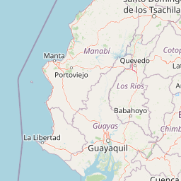
Use this park location map to pinpoint Reserva Marina El Pelado in Ecuador, understand its exact geographic position, and read its mapped placement within the surrounding landscape more clearly.

Pigeon | © OpenStreetMap contributors

Location context for Reserva Marina El Pelado

Santa Elena

Visualizing marine habitats, rocky reefs, and coastal ecosystems

Reserva Marina El Pelado Photos and Landscape Scenery

Visual documentation reveals the diverse marine environments and submarine shoals that define Reserva Marina El Pelado. Examining these protected area photos provides clearer insight into local oceanographic conditions, coastal terrain, and benthic habitat zones.

A three-panel composite image showing close-up underwater photographs of three different types of zoanthids, each labeled with its scientific name.

A four-panel grid showing underwater coral reefs with distinct colorful octocoral colonies, with white text labels identifying species names.

A small, rocky island surrounded by ocean waves under a hazy sky.

A wide angle sunset view over the ocean with buildings visible in the foreground along the coast.

Park atlas

Compare adjacent marine reserves and coastal protected landscapes across Ecuador.

Explore Other Parks Near Reserva Marina El Pelado and Surrounding Protected Areas

Continue browsing regional marine reserves and coastal protected areas connected to the equatorial front. Comparing adjacent habitats reveals broader ecological patterns across the Tropical Eastern Pacific coastline.
National parkManabí Province
About 28 km away#1 closest

North

Machalilla National Park: Protected Area and Geographic Context in Manabí Province

Explore mapped natural landscapes and regional geography.

Delve into Machalilla National Park, a protected national park situated in Ecuador's Manabí Province. This page provides a focused view on its protected landscape character, emphasizing its geographic setting and mapped natural terrain. Understand how Machalilla National Park fits into the regional geography, offering a distinct case study for protected-area discovery and landscape atlas exploration.

Area
750.59 km²
Established
1979
IUCN
II
Wildlife reserveSanta Elena
About 41 km away#2 closest

Southwest

Reserva de Producción de Fauna Marino Costero Puntilla Santa Elena Protected Area Map

Coastal marine geography and Pacific wildlife habitat exploration.

Investigate the marine-coastal expanse of the Reserva de Producción de Fauna Marino Costero Puntilla Santa Elena. This protected area encompasses diverse Pacific habitats, from arid shoreline vegetation to vast ocean sectors, serving as a critical environment for marine mammal migration and conservation in Santa Elena.

Area
524.34 km²
Relief
Lowland
Climate
Arid
Access
Easy access
A horizontal watercolor painting showing a stylized forest landscape with soft pastel green, yellow, and pink hues representing trees and rolling hills.
Protected areaGuayas
About 90 km away#3 closest

East

Bosque Protector Cerro Blanco: Protected Area and Tropical Dry Forest Geography in Guayas

Mapped terrain of the Chongon-Colonche mountain range

Bosque Protector Cerro Blanco functions as a major conservation site in coastal Ecuador, protecting rare Tumbesian forest ecosystems within the Guayas province. The reserve features diverse topography of ridges and valleys, serving as a critical buffer for regional endemic species and offering a unique look at seasonally dry forest landscapes near Guayaquil.

Area
60.78 km²
Established
1992
Visitors
12K annual
Relief
Upland
Wildlife reserveGuayas
About 92 km away#4 closest

Southeast

Refugio de Vida Silvestre Manglares El Morro: Protected Coastal Landscape and Map

A strategic marine and mangrove ecosystem in the Guayas Province

The landscape of Refugio de Vida Silvestre Manglares El Morro consists of continuous mangrove forests and rocky farallones, linked by a complex network of tidal channels. This wildlife refuge serves as an essential marine habitat at the threshold of the Gulf of Guayaquil, showcasing the interplay between tidal aquatic systems and coastal vegetation across the southwestern Ecuadorian region.

Area
101.3 km²
Established
2007
IUCN
Ib
Visitors
23K annual
Nature reserveGuayas
About 95 km away#5 closest

East

Bosque Protector La Prosperina Nature Reserve and Coastal Ecuador Forest Geography

Protected dry forest habitat and regional geographic terrain

Bosque Protector La Prosperina represents a critical survival of Ecuador's equatorial dry forest within the Guayas province. This nature reserve offers deep insight into seasonal ravine networks, drought-adapted vegetation, and the structural dynamics of fragmented coastal landscapes near Guayaquil.

Area
2.424 km²
Established
1994
Relief
Upland
Climate
Tropical
Wildlife reserveManabí
About 97 km away#6 closest

North

Refugio de Vida Silvestre Marino Costera Pacoche: Geography and Protected Area Atlas

Coastal and forest protected landscapes in Manabí, Ecuador

Examine the unique geographic structure of Refugio de Vida Silvestre Marino Costera Pacoche, a protected reserve bridging the Tumbesian dry forest and the Pacific Ocean. This atlas entry focuses on the park's coastal cliffs, sediment-rich marine zones, and forest ridges, providing a clear visual and descriptive record of this ecologically significant Manabí sanctuary.

Established
2008
IUCN
V
Visitors
3.2K annual
Relief
Mixed relief
Wildlife reserveGuayas
About 100 km away#7 closest

East

Reserva de producción de fauna Manglares El Salado: Coastal Geography and Protected Lands

A mangrove-dominated wildlife reserve in Guayas, Ecuador.

Analyze the protected landscape of Reserva de producción de fauna Manglares El Salado, which spans extensive mangrove forests and estuarine waters within the Guayas province. This wildlife reserve showcases a unique transition between intertidal mangrove zones, salt flats, and remnants of tropical dry forest, providing essential habitat context for the Gulf of Guayaquil coastal region.

Area
53.09 km²
Established
2002
IUCN
VI
Relief
Lowland
A pale, soft watercolor painting showing a stylized, rolling landscape with light green, pink, and yellow hues representing hills and trees.
Nature reserveGuayas Province
About 117 km away#8 closest

Southeast

Reserva ecológica Manglares Churute: Mapping a Coastal Nature Reserve in Guayas Province

An ecological mosaic of mangrove forests, estuaries, and forested ridges.

Spanning from the inner Gulf of Guayaquil into the Churute hill range, Reserva ecológica Manglares Churute acts as an essential protected area within Ecuador. The region contains one of the country's most significant mangrove complexes, complemented by freshwater lagoons and unique fog-affected forest summits that support diverse wildlife populations and endemic vegetation.

Area
471.74 km²
Established
1979
IUCN
Ia
Relief
Mixed relief

Common questions about visiting, size, designation, and location context for Reserva Marina El Pelado

Reserva Marina El Pelado FAQs for park facts, access, geography, and protected area context

Find quick answers about Reserva Marina El Pelado, including protected-area facts, park geography, trail and visitor context, and how the park fits into its surrounding country and regional landscape.
MoriAtlas Explorer

Continue Your Protected Areas Search Across the Global Atlas

Deepen your exploration by continuing the structured search for national parks and protected areas worldwide. Utilize the comprehensive filtering capabilities to compare different conservation landscapes and refine your understanding of global park geography. Discover more about the distribution and characteristics of protected natural areas.

Global natural geography
