
Mori Atlas logo
Nature reserveRéserve naturelle nationale de la baie de Saint-Brieuc

Examining the tidal mudflats, salt marshes, and coastal terrain of this French nature reserve.

Réserve naturelle nationale de la baie de Saint-Brieuc: Mapped Protected Landscapes in Côtes-d'Armor

The Réserve naturelle nationale de la baie de Saint-Brieuc protects a massive intertidal landscape on the Brittany coast, characterized by some of the most significant tidal ranges in the world. This nature reserve serves as an essential ecological junction within the Côtes-d'Armor department, encompassing vast sandy foreshores, expansive Yffiniac salt marshes, and rugged coastal cliffs. Mapped boundaries reveal a dynamic environment shaped by the rhythmic interplay of the English Channel tides, forming a rich habitat for coastal flora and migratory wildlife.

coastal reservetidal mudflatsintertidal flatssalt marshprés salésdunes
A minimalist, flat-style digital illustration showing a winding river flowing toward a coastline, with a small waterfall spilling from green cliffs, surrounded by simplified trees under a light sky.

Réserve naturelle nationale de la baie de Saint-Brieuc

Nature reserve

Park overview

Structured park overview, official facts, and landscape profile for Réserve naturelle nationale de la baie de Saint-Brieuc

Réserve naturelle nationale de la baie de Saint-Brieuc park facts, protected area profile, and essential visitor context

Review the core facts for Réserve naturelle nationale de la baie de Saint-Brieuc, including designation, size, terrain, visitor scale, habitats, and operating context in one park-focused overview.

About Réserve naturelle nationale de la baie de Saint-Brieuc

The Réserve naturelle nationale de la baie de Saint-Brieuc occupies the southern sector of the Bay of Saint-Brieuc, a wide and shallow embayment of the English Channel in northern Brittany. Created as a national nature reserve in 1998, it protects a continuous gradient of coastal habitats from open sea to fully terrestrial dune and cliff environments, anchored on the Yffiniac and Morieux inlets and the surrounding intertidal flats.

Although modest in its terrestrial footprint, the reserve gains its true significance from the sea. The bay's strong tides expose around 800 square kilometers of sandy and muddy foreshore, concentrating nutrients and supporting dense communities of benthic invertebrates. This productivity ripples upward through the food web: prawns, cockles, worms, and small crustaceans feed flatfish such as plaice and sole, and in turn fuel one of France's most important coastal concentrations of wintering and migratory birds.

Beyond its wildlife value, the site is also an important landscape and geological asset. The bay combines young Quaternary sediments with much older formations, including gneiss, amphibolites with pillow lavas, arkose, and greywacke, giving the site international geological interest. Above the tidal zone, the reserve embraces broken coastal cliffs, dunes, vegetated shingle, and the brackish Yffiniac marsh, where a full range of halophytic vegetation develops from low slikke to high schorre. Managed jointly by the local agglomeration and an experienced naturalist association, the reserve serves both conservation and public education through the Maison de la Baie visitor center in Hillion and the GR34 coastal path that traces its edge.

Quick facts and research context for Réserve naturelle nationale de la baie de Saint-Brieuc

The Réserve naturelle nationale de la baie de Saint-Brieuc is a national nature reserve in Brittany, northwestern France, created by decree on 28 April 1998. It lies within the department of Côtes-d'Armor, on the southern shore of the Bay of Saint-Brieuc, and spans the communes of Hillion, Langueux, Morieux, Saint-Brieuc, and Yffiniac.

The protected area totals about 1,140 hectares, the vast majority of which lies on the maritime public domain as intertidal flats and salt marshes, with only a small terrestrial component including the Bon Abri dunes. It is managed jointly by Saint-Brieuc Agglomeration and the association VivArmor Nature. Ecologically, the bay is the fifth largest in the world by tidal amplitude and supports more than 50,000 wintering birds each year.

Protection and recognition

Documented protection scope and recognition records for this coastal protected area

Protection Status and International Recognition for Réserve naturelle nationale de la baie de Saint-Brieuc

Exploration of Réserve naturelle nationale de la baie de Saint-Brieuc reveals documented protection status and mixed management scope within the global protected area registry. Structured records provide transparent access to official conservation designations and administrative identifiers without added commentary.

Protection details

Protection scope
Mixed
Transboundary protection
No
WDPA ID
178260
Park context

Deeper park guide and search-rich context for Réserve naturelle nationale de la baie de Saint-Brieuc

Réserve naturelle nationale de la baie de Saint-Brieuc history, landscape, wildlife, and travel context

Explore Réserve naturelle nationale de la baie de Saint-Brieuc through its history, landscape character, ecosystems, wildlife, conservation priorities, cultural context, and seasonal travel timing in a structured park guide built for atlas discovery and search intent.

Why Réserve naturelle nationale de la baie de Saint-Brieuc stands out

The reserve is best known for its exceptionally productive intertidal mudflats and its importance as a stopover and wintering site for tens of thousands of shorebirds and waterfowl along the East Atlantic flyway. The Yffiniac marsh, the second-largest stretch of salt marsh on the North-Armorican coast, also gives the site a distinctive botanical and landscape identity within Brittany. Equally important is its position within the Bay of Saint-Brieuc, one of the world's top five bays by tidal range, whose rhythmic uncovering of sand and mud fuels dense invertebrate communities, sustains flatfish populations, and ultimately feeds the vast bird concentrations that winter along the Brittany coast.
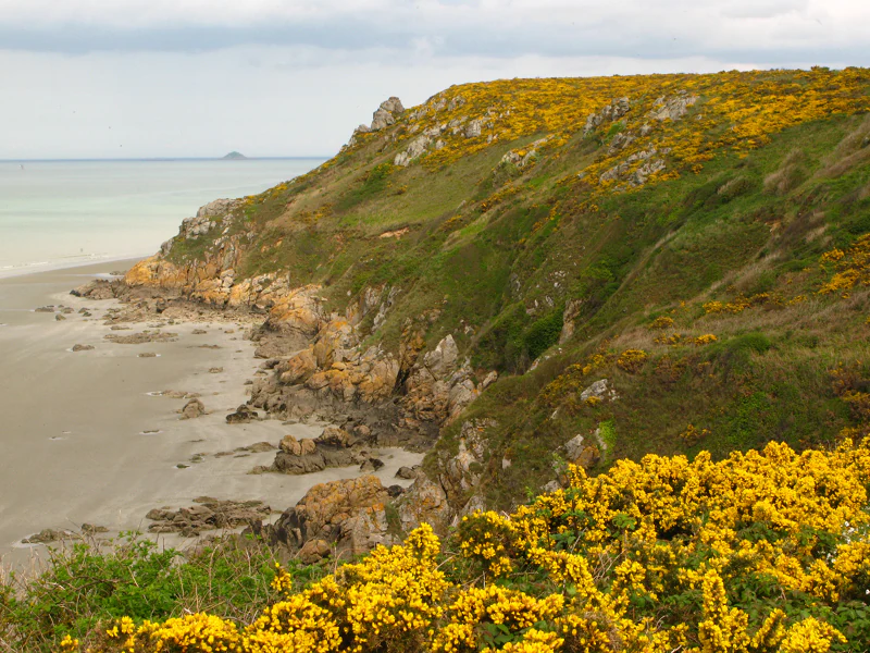
A view of rugged coastal cliffs meeting a sandy beach, with bright yellow gorse flowers covering the foreground and hillside.
Coastal cliffs at Planguenoual in the Baie de Saint-Brieuc National Nature Reserve, featuring blooming gorse.

Réserve naturelle nationale de la baie de Saint-Brieuc history and protected-area timeline

The bay's ecological importance was recognized well before the creation of today's reserve. In 1973, the Anse d'Yffiniac was designated as a maritime hunting reserve, marking an early step in formal protection of its birdlife. The first proposals for full natural-reserve status emerged in 1981, partly as a compensatory measure linked to the expansion of the port of Légué, although the formal designation process only began in the early 1990s.

Following several years of study, consultation, and planning, the reserve was officially established by decree on 28 April 1998. In 2005, a management agreement transferred day-to-day stewardship to Saint-Brieuc Agglomération together with the naturalist association VivArmor Nature. Successive management plans, including the 2004-2008 plan and the 2014-2018 plan, have since shaped monitoring, public engagement, and habitat protection on the site.

Réserve naturelle nationale de la baie de Saint-Brieuc landscape and geographic character

The landscape of the reserve is shaped overwhelmingly by water and tide. Its core is the wide, shallow southern bay, where every low tide reveals an immense sweep of sandy and muddy foreshore crossed by shifting channels and edged by reedbeds and salt marsh. Tidal amplitude here is exceptional: the Bay of Saint-Brieuc ranks among the world's five largest bays by tidal range, lending the entire site a constantly changing, rhythmical quality.

Above the tidal flats the terrain rises gently into the Yffiniac and Morieux inlets, fringed by extensive salt marshes crossed by a network of tidal creeks. Inland the coast becomes more rugged, with short sea cliffs, vegetated shingle, and the prominent dune system of Bon Abri at Hillion, forming the reserve's main terrestrial component. The geological substrate is correspondingly varied, mixing ancient gneiss and amphibolite formations with younger Quaternary marine sediments, giving the bay a layered character that is both visually diverse and scientifically distinctive.
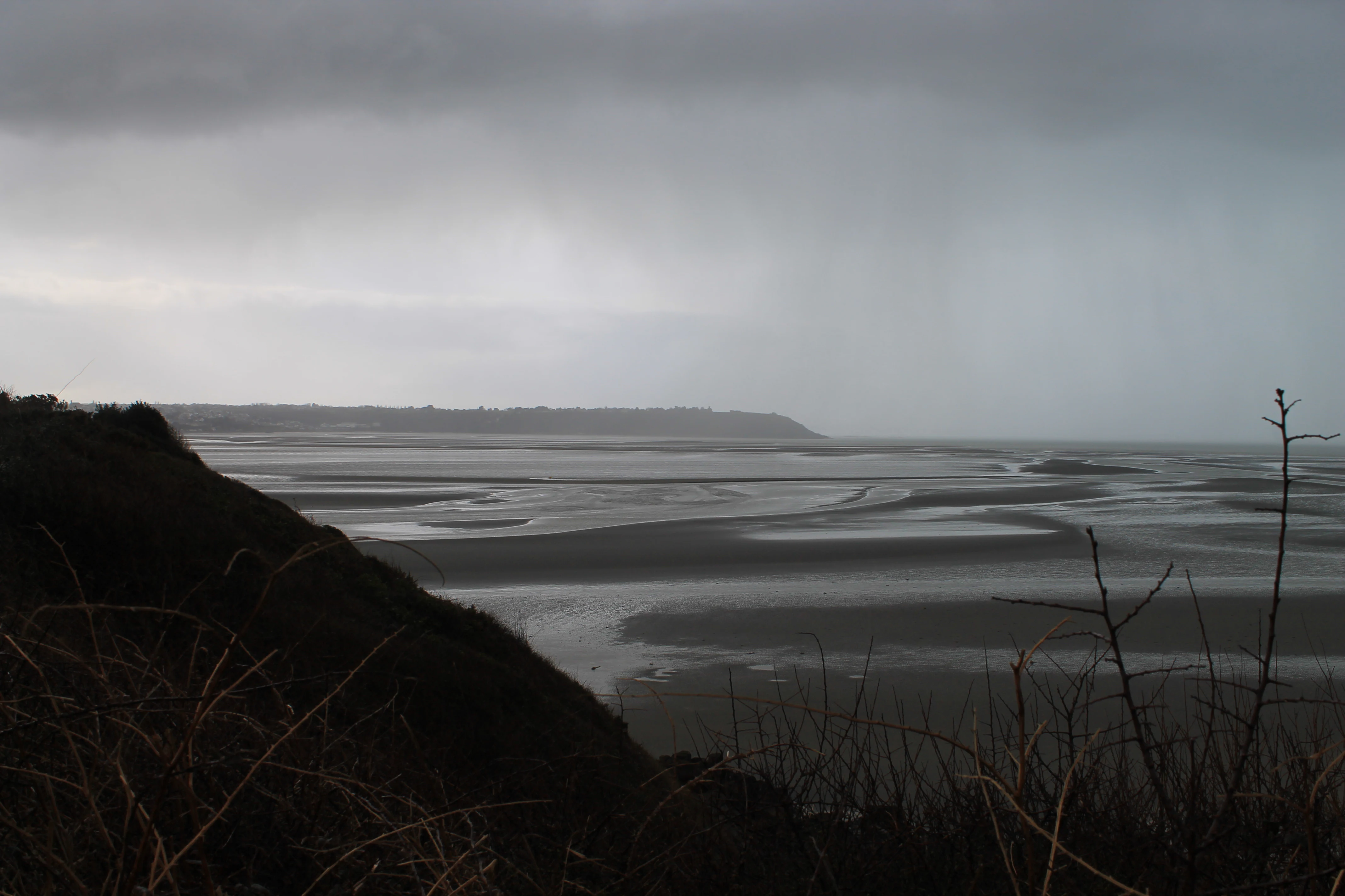
Wide landscape view of an expansive, dark tidal mudflat under a heavy, overcast grey sky, seen from a hillside overlooking the bay.
A moody, low-tide view of the Bay of Saint-Brieuc seen from the coastal vantage point of Pointe du Grouin.

Réserve naturelle nationale de la baie de Saint-Brieuc ecosystems, habitats, and plant life

Ecologically, the reserve is defined by a continuum of marine, intertidal, and brackish-terrestrial habitats. The slikke and schorre of the Yffiniac marsh host a full suite of halophytic plant communities, including sea purslane (Obione) and maritime sweet-grass (Glycérie maritime), making it the second-largest stretch of salt marsh on the North-Armorican coast after the Bay of Mont-Saint-Michel. Coastal cliff vegetation and dune flora further enrich the small but botanically diverse terrestrial zone.

The intertidal flats themselves are equally important ecologically. High phytoplankton productivity drives dense benthic communities, and fine sands in particular support around 58 macro-invertebrate species. These invertebrates underpin the entire food web of the bay, from flatfish and crustaceans to the tens of thousands of birds that depend on the site each winter. Two reinforced protection zones have also been defined within the reserve, focusing on the most sensitive parts of the Yffiniac inlet and the Gouessant estuary.
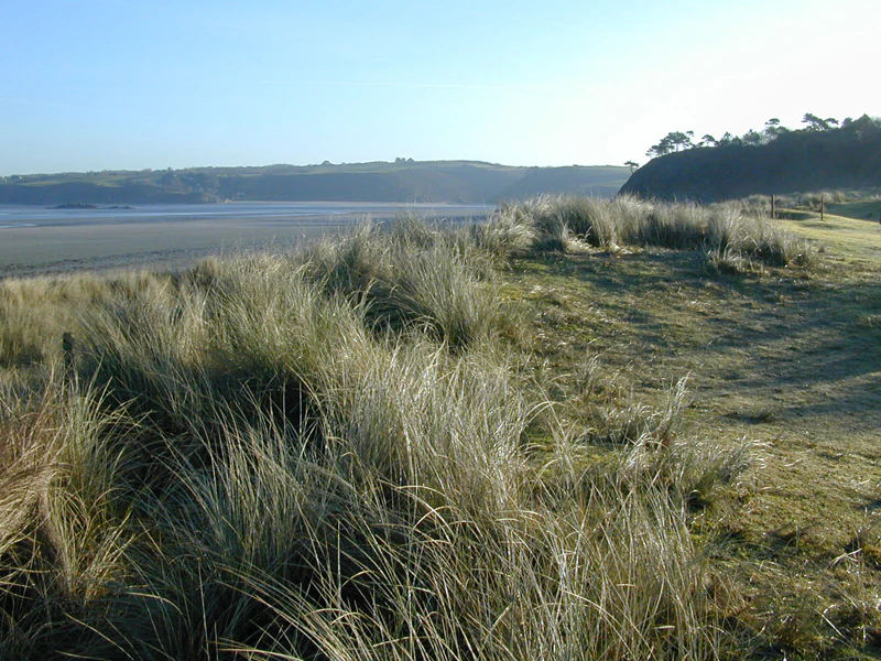
Coastal sand dunes covered in tall beach grasses overlooking a wide tidal mudflat in the distance under a clear sky.
The dunes at Bon Abri within the Réserve naturelle nationale de la baie de Saint-Brieuc.

Réserve naturelle nationale de la baie de Saint-Brieuc wildlife and species highlights

The reserve's most visible wildlife is its birdlife. Systematic monitoring has been carried out since 1970, showing that the bay functions both as a major migratory stopover and as an important wintering ground, with strong year-to-year fluctuations in numbers. Mid-January counts regularly record Eurasian oystercatcher, dunlin, red knot, brent goose, bar-tailed godwit, Eurasian wigeon, common scoter, Eurasian curlew, northern pintail, mallard, common teal, and grey plover among the most numerous species.

The intertidal flats also support a rich marine fauna. Cockles, prawns, polychaete worms, and other invertebrates thrive in the fine sands and muds, sustaining flatfish such as plaice and sole, and contributing to the broader productivity of the western Channel. Harbor seals are occasional visitors, most often recorded during summer and autumn, adding a marine mammal interest to the otherwise bird-dominated wildlife profile.
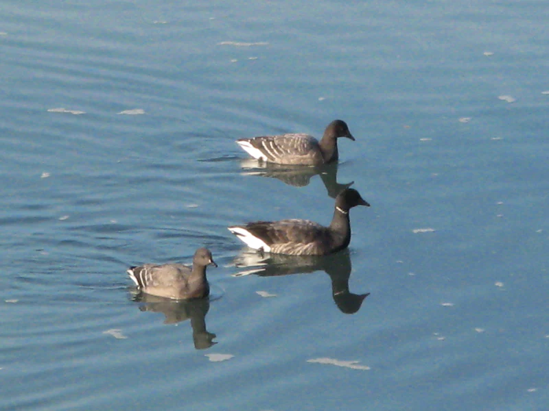
Three Brent geese swimming in calm water, seen from a high angle.
Brent geese swimming in the Saint-Brieuc Bay nature reserve.

Réserve naturelle nationale de la baie de Saint-Brieuc conservation status and protection priorities

The reserve's conservation value derives primarily from the exceptional productivity of its tidal ecosystem and its role within the East Atlantic flyway. Its mudflats and salt marshes act as both a feeding ground and a refuge at a continental scale, supporting more than 50,000 birds each winter and hosting internationally important concentrations of several wader and wildfowl species. Reinforced protection zones in the southern Yffiniac inlet and the Gouessant estuary strengthen the conservation framework for the most sensitive habitats.

The site is also integrated into wider French and European conservation networks. It forms part of the Natura 2000 site 'Baie de Saint-Brieuc - Est', and its long-running monitoring programs, conducted in partnership with scientific institutions, provide detailed insight into the dynamics of the bay's benthic, fish, and bird populations, contributing to evidence-based management of the broader coastal ecosystem.

Réserve naturelle nationale de la baie de Saint-Brieuc cultural meaning and human context

The bay has long shaped local identity in the Saint-Brieuc region, supporting traditional activities such as shellfish harvesting, small-scale coastal fishing, and shore-based hunting. The century-old Maison de la Baie at Hillion reflects the strong local tradition of engaging with the marine environment and now serves as the reserve's main visitor and educational center. The GR34 long-distance footpath, which traces the Breton coastline, runs along the edge of the reserve, weaving the site into the broader cultural landscape of the Breton coast.

Top sights and standout views in Réserve naturelle nationale de la baie de Saint-Brieuc

Among the reserve's strongest points of distinction are the exceptionally productive tidal mudflats with their dense benthic communities, the Yffiniac salt marshes, which form the second-largest complex of prés salés on the North-Armorican coast, and the regularly recorded concentrations of tens of thousands of wintering shorebirds and waterfowl. The added presence of the Bon Abri dunes, the rugged coastal cliffs west of Hillion, and the geological diversity of ancient gneiss, amphibolites, and Quaternary sediments give the reserve a layered identity that combines marine, wetland, and terrestrial values.

Best time to visit Réserve naturelle nationale de la baie de Saint-Brieuc

The reserve's atmosphere changes dramatically with the tides, with low tide revealing the full extent of the mudflats and creating the richest wildlife viewing opportunities, while high tide pushes birds toward the edges of the bay. Winter is the most ecologically dramatic season, when the bay hosts its largest gatherings of waders and waterfowl, whereas late spring and summer are better for enjoying the cliff and dune flora, observing breeding birdlife, and, with some luck, encountering harbor seals along the shoreline.
Monthly climate preview

Long-term representative point measurements tracking monthly temperature ranges and precipitation patterns

Réserve naturelle nationale de la baie de Saint-Brieuc Climate Normals and Annual Weather Rhythm

Representative coordinate records show average temperatures ranging from winter lows around 6 degrees Celsius to summer highs approaching 28 degrees Celsius alongside consistent monthly precipitation. Detailed twelve-month climate profiles provide comprehensive historical context for analyzing long-term meteorological trends across the protected coastal ecosystem.
Annual mean11 °C
6 °C18 °C
Jan
Feb
Mar
Apr10°
May13°
Jun15°
Jul17°
Aug18°
Sep16°
Oct13°
Nov
Dec
Warmest month
August

17.6 °C

Coolest month
January

6.1 °C

Wettest month
November

2.9 mm/day

Driest month
July

1.5 mm/day

Park location guide

Geography guide, regional context, and park location map for Réserve naturelle nationale de la baie de Saint-Brieuc

Réserve naturelle nationale de la baie de Saint-Brieuc park geography, regions, and map view in France

Understand where Réserve naturelle nationale de la baie de Saint-Brieuc sits in France through a broader geographic reading of the surrounding landscape, nearby location context, and its mapped position within the national park landscape.

How Réserve naturelle nationale de la baie de Saint-Brieuc fits into France

France is a unitary semi-presidential republic and one of the world's largest economies. It borders Belgium, Luxembourg, Germany, Switzerland, Italy, Monaco, Andorra, and Spain, with a maritime border to the United Kingdom. The country is known for its cultural influence, art, cuisine, and political history spanning centuries.

Wider geography shaping Réserve naturelle nationale de la baie de Saint-Brieuc in France

France is located in Western Europe. Metropolitan France extends from the Rhine to the Atlantic Ocean and from the Mediterranean Sea to the English Channel and North Sea. The country borders Belgium, Luxembourg, Germany, Switzerland, Italy, Monaco, Andorra, Spain, and has a maritime border with the United Kingdom.

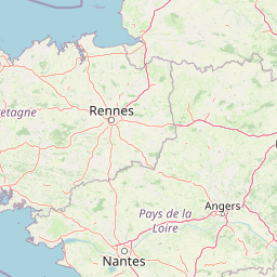
Map view of Réserve naturelle nationale de la baie de Saint-Brieuc

Use this park location map to pinpoint Réserve naturelle nationale de la baie de Saint-Brieuc in France, understand its exact geographic position, and read its mapped placement within the surrounding landscape more clearly.

Pigeon | © OpenStreetMap contributors

Location context for Réserve naturelle nationale de la baie de Saint-Brieuc

Côtes-d'Armor

Visual exploration of tidal mudflats, salt marshes, and coastal habitats across northern Brittany

Réserve naturelle nationale de la baie de Saint-Brieuc Photos and Landscape Scenery

Visual records reveal the vast expanses of intertidal mudflats, winding salt marshes, and rugged coastal dunes that define the protected terrain. Examining these protected habitats provides deeper insight into the tidal rhythms and shorebird environments shaping the northern Brittany coast.

A view of rugged coastal cliffs meeting a sandy beach, with bright yellow gorse flowers covering the foreground and hillside.

Wide shot of a vast sandy tidal flat under a pale sky, with shallow water channels and a dark headland visible in the distance.

Wide landscape view of an expansive, dark tidal mudflat under a heavy, overcast grey sky, seen from a hillside overlooking the bay.

Coastal sand dunes covered in tall beach grasses overlooking a wide tidal mudflat in the distance under a clear sky.

Three Brent geese swimming in calm water, seen from a high angle.

Park atlas

Compare nearby coastal reserves, tidal flats, and protected natural landscapes across Brittany

Parks Near Réserve Naturelle Nationale de la Baie de Saint-Brieuc and Regional Protected Areas

Continuing exploration from Réserve naturelle nationale de la baie de Saint-Brieuc reveals connected coastal habitats and estuarine environments across the surrounding regional geography. Comparing nearby protected areas provides broader context on tidal ecosystems, wintering bird flyways, and marine landscapes.
A watercolor painting showing a soft, stylized landscape of green hills, marshy fields, and patches of pink wildflowers or heathland against a white background.
Nature reserveBretagne
About 63 km away#1 closest

Southwest

Réserve naturelle régionale des landes et marais de Glomel: Protected Bog and Heathland Atlas

A rare inland wetland refuge within the Bretagne Montagnes Noires

Explore the geographic mosaic of the Réserve naturelle régionale des landes et marais de Glomel, a protected area in Bretagne comprising dual sites of peat bogs, wet heaths, and marshy meadows. This atlas entry details the internal terrain, including the Grazius stream network and the historic canal environment, essential for understanding the habitat distribution and conservation of this distinct inland landscape.

Area
1.078 km²
Established
2008
IUCN
IV
Relief
Upland
Nature reserveBretagne
About 64 km away#2 closest

West

Réserve naturelle régionale des landes, prairies et étangs de Plounérin: Protected Habitat Atlas

Inland Bretagne landscape mosaic and regional nature reserve mapping

This protected area in the heart of Brittany serves as a vital refuge for heathland, meadows, and ponds. Examine the site's mapped boundaries and understand its role as an IUCN Category IV conservation landscape within the broader geography of the Côtes-d'Armor department.

Area
1.607 km²
Established
2016
IUCN
IV
Nature reserveFinistère
About 70 km away#3 closest

West

Vallée de l'Aulne Nature Reserve: A Detailed Mapping of Finistère River Valley Geography

Protected riparian landscapes, watershed ecology, and regional basin boundaries

The Vallée de l'Aulne serves as a central artery for the natural landscapes of western France. Spanning from inland Brittany toward the Atlantic, this protected reserve encompasses riverine corridors, bocage terrain, and tidal estuary zones. Use this detailed profile to examine the geographic distribution of protected habitats, river basin features, and the integrated environmental protections that define this key Finistère landscape.

Area
35.64 km²
Established
2014
Relief
Lowland
Climate
Temperate
A horizontal watercolor illustration of a soft green landscape with rolling hills, patches of grass, and distant tree lines against a white background.
Nature reserveBretagne
About 72 km away#4 closest

West

Réserve naturelle régionale des landes et tourbières du Cragou et du Vergam: Regional Park Geography

Protected granite ridges and Atlantic peatland ecosystems in Finistère

The Réserve naturelle régionale des landes et tourbières du Cragou et du Vergam stands as a critical reference for understanding Breton upland ecology. Spanning the Monts d'Arrée, these protected sites provide a distinct map of wet heath, acidic flushes, and diverse botanical habitats that define the inland character of northwestern France.

Area
3.434 km²
Established
2008
IUCN
IV
Relief
Upland
Nature reserveBretagne
About 80 km away#5 closest

Southeast

Réserve naturelle régionale des landes de Monteneuf: Geographic Landscape and Protected Area

Atlantic heathland mosaic and Neolithic heritage sites in Bretagne

The Réserve naturelle régionale des landes de Monteneuf serves as a vital refuge for Atlantic heathland habitats within the Bretagne region of France. Situated on thin, acidic schist soils, the area displays a textured mosaic of dry and humid moorland patches, small ponds, and prominent megalithic alignments. This protected territory offers a unique look at how historical land use maintains an open heathland ecosystem amidst a changing rural landscape.

Area
1.255 km²
Established
2013
IUCN
IV
Relief
Lowland
A watercolor painting showing a soft, panoramic view of a coastal wetland with small islands in the distance and grassy foreground dunes.
Regional parkBretagne
About 83 km away#6 closest

South

Parc naturel régional du Golfe du Morbihan: Coastal Landscape and Marine Park Geography

Protected maritime territory and island geography in Bretagne

Covering over 80,000 hectares of combined land and marine space, Parc naturel régional du Golfe du Morbihan offers a unique view into the intersection of Atlantic coastal heritage and environmental conservation. Learn about the park's structural role in the Bretagne region through its intricate network of inlets, peninsulas, and marshland habitats that define its distinctive maritime character.

Area
642 km²
Established
2014
IUCN
V
A soft watercolor illustration of a green wetland area with rolling hills and misty silhouettes in the background, set against a white background.
Nature reserveBretagne
About 87 km away#7 closest

East

Réserve naturelle régionale du marais de Sougeal: Regional Wetland and Protected Landscape in Bretagne

A managed floodplain sanctuary near the Bay of Mont-Saint-Michel

Located in the Ille-et-Vilaine department, this regional nature reserve preserves a unique strip of wet grassland and flood-prone meadows. Use our mapping data to understand the park's specific terrain, from its narrow channel systems to its role as a key stopover for migratory waterbirds and a communal grazing area in the heart of Bretagne.

Area
1.74 km²
Established
2006
IUCN
IV
Relief
Lowland
A watercolor painting showing a wide, panoramic view of a marshy landscape with green clumps of grass in the foreground and soft purple hills in the distance.
Nature reserveFinistère
About 90 km away#8 closest

West

Réserve naturelle nationale du Venec: Protected Peatland and Monts d'Arrée Geography

A core nature reserve and active sphagnum bog ecosystem in Finistère

Located in central Brittany, the Réserve naturelle nationale du Venec represents the only remaining large, active raised bog in the region. This protected area within the Finistère department offers deep insight into the geomorphology of the Yeun-Elez basin, mapping the transition from granite-edged dry moorland through marshy transition zones to the central, ombrotrophic peat dome.

Area
3.341 km²
Established
1993
IUCN
IV
Relief
Upland

Common questions about visiting, size, designation, and location context for Réserve naturelle nationale de la baie de Saint-Brieuc

Réserve naturelle nationale de la baie de Saint-Brieuc FAQs for park facts, access, geography, and protected area context

Find quick answers about Réserve naturelle nationale de la baie de Saint-Brieuc, including protected-area facts, park geography, trail and visitor context, and how the park fits into its surrounding country and regional landscape.
MoriAtlas Explorer

Continue Your Protected Areas Search Across the Global Atlas

Deepen your exploration by continuing the structured search for national parks and protected areas worldwide. Utilize the comprehensive filtering capabilities to compare different conservation landscapes and refine your understanding of global park geography. Discover more about the distribution and characteristics of protected natural areas.

Global natural geography