
Mori Atlas logo
Nature reserveRéserve naturelle nationale du Sabot de Frotey

Analyzing the limestone cliffs and steppe-like calcareous habitats of eastern France

Réserve naturelle nationale du Sabot de Frotey: A Geological and Botanical Protected Landscape

The Réserve naturelle nationale du Sabot de Frotey encompasses a distinct limestone plateau and eroded cliff system in the Haute-Saône department. This nature reserve protects a mosaic of dry calcareous grasslands, scrub, and rocky outcrops that serve as an essential biogeographical link between the Jura and Vosges mountains. The site is characterized by its iconic eponymous monolith and high biodiversity, particularly regarding orchid species and regional insect populations.

dry grasslandslimestone cliffcalcareous habitatsorchidsbutterfliesmoths
A stylized flat vector illustration of the Sabot de Frotey, a distinctive limestone rock formation surrounded by a coniferous forest under a soft sunset sky.

Réserve naturelle nationale du Sabot de Frotey

Nature reserve

Park overview

Structured park overview, official facts, and landscape profile for Réserve naturelle nationale du Sabot de Frotey

Réserve naturelle nationale du Sabot de Frotey park facts, protected area profile, and essential visitor context

Review the core facts for Réserve naturelle nationale du Sabot de Frotey, including designation, size, terrain, visitor scale, habitats, and operating context in one park-focused overview.

About Réserve naturelle nationale du Sabot de Frotey

The Réserve naturelle nationale du Sabot de Frotey occupies a slender but ecologically intense strip of countryside on the edge of Vesoul. Its setting is defined by a long limestone cliff that rises above the Durgeon valley, facing southwest and eroded over millennia into a series of pinnacles and monoliths, the most famous of which has the unmistakable shape of a horseshoe or sabot. Above and around this cliff stretches a plateau of dry calcareous grasslands, dotted with boxwood scrub, isolated trees, and patches of pine, forming a Mediterranean-flavored habitat that contrasts sharply with the surrounding agricultural lowlands of Haute-Saône.

Ecologically, the reserve functions as a stepping stone between two major biogeographical influences: the calcareous Jura mountains to the south and the more acidic Vosges massif to the north. Its dry grasslands, cliff faces, and ecotones between open and wooded terrain together create a wide range of microhabitats within a very compact surface area, which is a key reason the site was given national-protection status in 1981.

The reserve is also an important cultural and educational site for the region. Naturalists have visited the Sabot de Frotey since the 19th century, drawn first by the striking geological formation and later by increasingly well-documented botanical and entomological discoveries. Today it remains a popular walking destination near Vesoul, with marked trails that allow visitors to experience both the panoramic cliff-top views and the surprisingly species-rich grasslands of this small but exceptional protected area.

Quick facts and research context for Réserve naturelle nationale du Sabot de Frotey

The Réserve naturelle nationale du Sabot de Frotey is a French national nature reserve located in the Haute-Saône department of the Bourgogne-Franche-Comté region, within the commune of Frotey-lès-Vesoul and in the immediate hinterland of Vesoul. Classified by decree on 28 August 1981, it covers approximately 98 hectares and is managed by the Association Gestion Sabot Frotey together with LPO Franche-Comté.

Its terrain is dominated by a southwest-facing limestone cliff more than 600 meters long and up to 40 meters high, edged with dry calcareous grasslands and patches of pine woodland. The site is recognized as a biogeographical corridor between the Jura and Vosges massifs and is notable for exceptionally rich flora and insect fauna.

Protection and recognition

Explore terrestrial protected area designations and documented management records.

Réserve naturelle nationale du Sabot de Frotey Protection Status and Conservation Data

Terrestrial protection status, management scope, and verified registry records anchor the conservation profile for Réserve naturelle nationale du Sabot de Frotey. Systematic registry entries and official baseline datasets provide structured insight into the protected landscape without external designation claims.

Protection details

Protection scope
Terrestrial
Transboundary protection
No
WDPA ID
39782
Park context

Deeper park guide and search-rich context for Réserve naturelle nationale du Sabot de Frotey

Réserve naturelle nationale du Sabot de Frotey history, landscape, wildlife, and travel context

Explore Réserve naturelle nationale du Sabot de Frotey through its history, landscape character, ecosystems, wildlife, conservation priorities, cultural context, and seasonal travel timing in a structured park guide built for atlas discovery and search intent.

Why Réserve naturelle nationale du Sabot de Frotey stands out

The reserve is best known for its dry calcareous grasslands perched above an eroded limestone cliff, and especially for the abundance and diversity of orchids and butterflies that thrive in these open habitats. More than 440 plant species have been recorded, including a regionally rare population of Apennine rock-rose that blooms spectacularly along the corniche in May and June, and around twenty orchid species shared among the grasslands, hedges, and open scrub. The site is also recognized as one of the few locations in Franche-Comté hosting both the sulphur and amber owlfly species. The cliff itself, with its sculpted eponymous 'Sabot' monolith, gives the reserve a strong visual identity that combines geological curiosity with botanical richness.
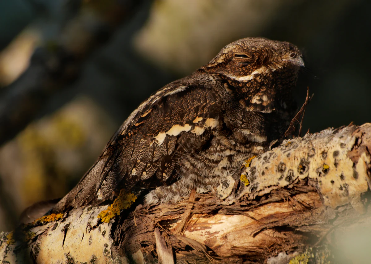
A European Nightjar perching on a textured, lichen covered tree branch, blending into the surrounding woodland environment with its mottled brown plumage.
A European Nightjar resting on a branch, showcasing its remarkable camouflage.

Réserve naturelle nationale du Sabot de Frotey history and protected-area timeline

The Sabot de Frotey monolith was first recognized for its natural significance in the early 20th century, when it received a ministerial classification in 1913. Even earlier, the site had attracted the attention of 19th-century naturalists, drawn both by its unusual geology and its distinctive dry-meadow flora.

During the 1960s and 1970s, botanists began to document the reserve's most celebrated botanical feature: the abundant spring flowering of the Apennine rock-rose along the cliff edge. At the same time, abandonment of the traditional sheep, goat, and cattle grazing on communal dry grasslands, beginning around 1965, allowed shrubs and trees, especially black pines, to gradually colonize the open spaces.

In response to these ecological changes and to growing urbanization pressure around Vesoul, the French state created the national nature reserve by decree on 28 August 1981, with the explicit goal of protecting this biogeographical link between the Jura and Vosges massifs. Since 1988, annual restoration work, including pine felling and boxwood cutting, has been carried out to reopen the grasslands and to maintain the mosaic of meadows, hedges, and small woodlands that gives the site its conservation value.

Réserve naturelle nationale du Sabot de Frotey landscape and geographic character

The defining feature of the reserve is a southwest-facing limestone cliff more than 600 meters in length, rising to about 40 meters at its tallest point. Erosion has carved this cliff into a series of isolated monoliths and pinnacles, of which the Sabot de Frotey is the most iconic, taking its name from a rock that resembles an upturned horseshoe.

Above the cliff stretches a plateau of dry calcareous grassland, interrupted by low boxwood scrub, scattered shrubs, isolated deciduous trees, and stands of black pine. This open, steppe-like terrain contrasts with the moister, more wooded lowlands of the surrounding Saône plateau and gives the reserve its distinctive semi-arid appearance. To the north and east, the plateau slopes more gently and grades back into mixed farmland and forest typical of the Haute-Saône landscape.
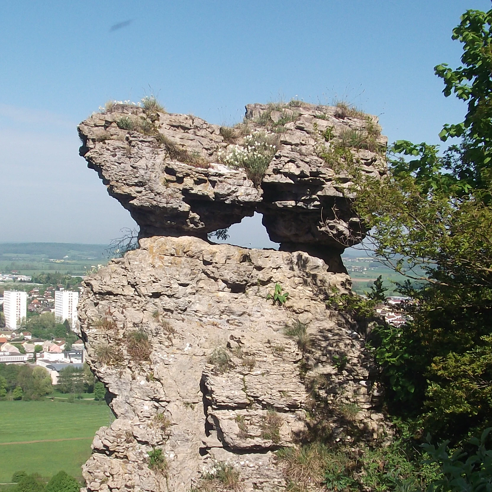
A large, weathered limestone rock formation shaped like a clog or mushroom, with a small hole in its center, overlooking a town and green valley in the distance.
The Sabot de Frotey, a distinctive limestone geological formation within the nature reserve.

Réserve naturelle nationale du Sabot de Frotey ecosystems, habitats, and plant life

The habitats of the reserve belong to the dry calcareous grassland complex typical of southern European hill country, with several variations depending on soil depth, exposure, and grazing history. The most extensive habitat is open xerothermic grassland on thin limestone soils, where specialised plants such as the Apennine rock-rose, various orchids, and a rich assemblage of Mediterranean-influenced herbs find refuge.

Along the cliff, communities of chasmophytic plants colonize the rock faces and ledges, while fringes of boxwood and scattered deciduous trees form transitional habitats between open grassland and woodland. Small planted or spontaneously established stands of black pine, partly a legacy of 20th-century afforestation, are actively managed to prevent them from closing over the grasslands, and a network of hedges, thickets, and isolated trees is deliberately maintained to preserve habitat diversity.
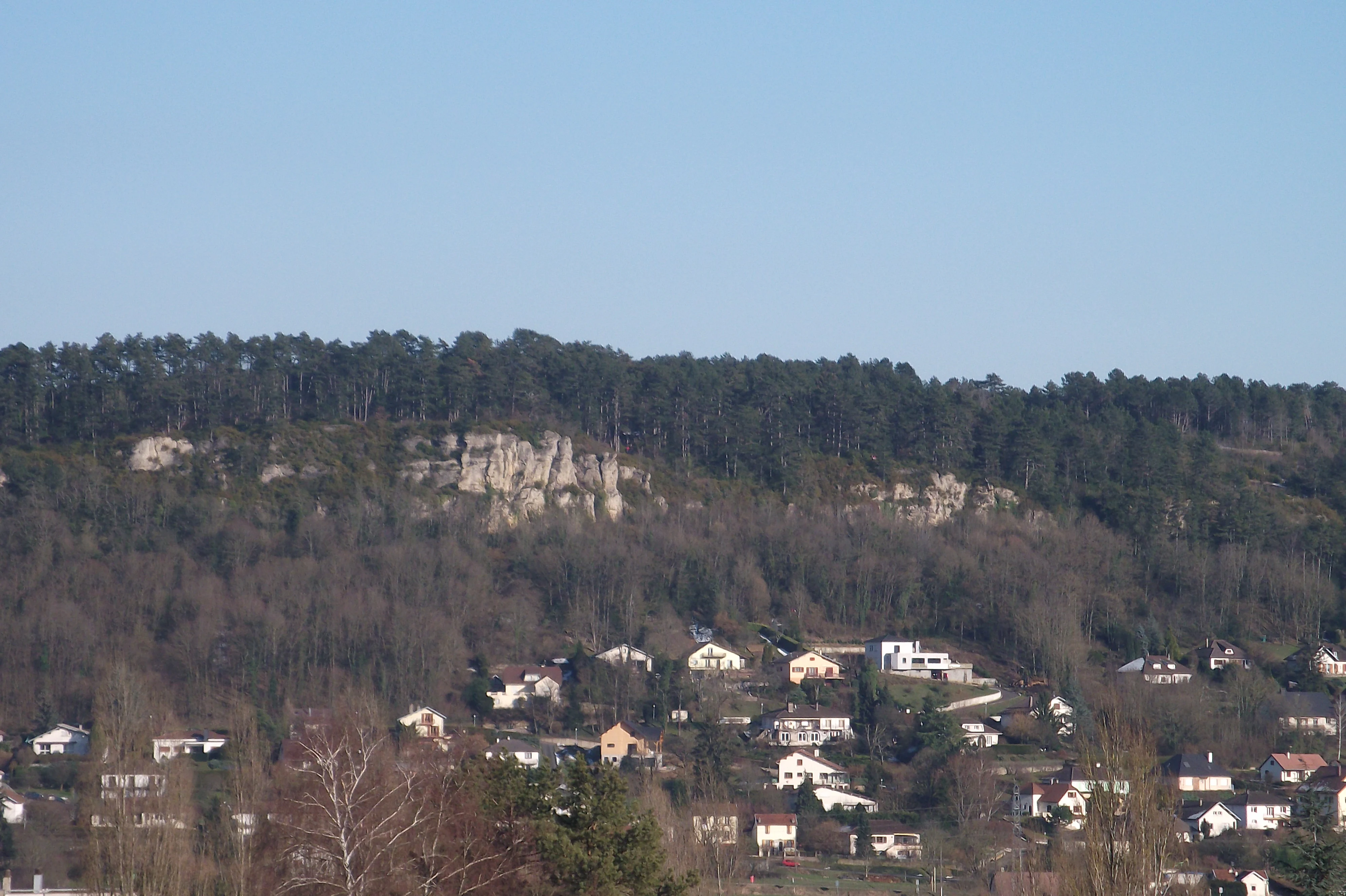
A wide shot showing a forested hillside topped with limestone rock formations above a residential area, under a clear blue sky.
A view of the Sabot de Frotey National Nature Reserve, featuring its signature limestone cliff rising above the surrounding town.

Réserve naturelle nationale du Sabot de Frotey wildlife and species highlights

Although small, the reserve supports a remarkably diverse fauna shaped by the warm, dry microclimate of its south-west facing cliff and grasslands. Birdlife includes woodland species such as the black woodpecker alongside more characteristic dry-meadow specialists like the woodlark and cirl bunting, and the European nightjar, a nocturnal bird that depends on the abundance of insects in the grasslands.

The most exceptional wildlife feature of the site is its entomological richness. Orthopterans are represented by around 39 species, including the Italian tree cricket, the blue-winged grasshopper, and the wart-biter bush-cricket. The reserve is also one of very few in Franche-Comté to host both the sulphur owlfly and the amber owlfly, while more than 500 species of moths and about a hundred butterfly species have been recorded, among them the Large Blue, which depends on thyme-rich grasslands. Since the early 2000s, several moth species of more southerly distribution have been regularly observed, suggesting a gradual northward shift in the area's insect fauna.

Réserve naturelle nationale du Sabot de Frotey conservation status and protection priorities

The reserve's principal conservation value lies in its role as a protected refuge for xerothermic habitats that have become scarce across much of north-western Europe. Its dry calcareous grasslands, cliff vegetation, and transitional scrub-woodland mosaic support a high concentration of specialist plant and insect species within a very small area.

By protecting this habitat complex, the reserve helps maintain a biogeographical corridor between the Jura and Vosges massifs and preserves important populations of regionally rare plants such as the Apennine rock-rose and of threatened insect assemblages. Active management, including periodic clearing of invasive pines and boxwood, is essential to counter woodland encroachment following the abandonment of traditional grazing. The site is also a reference location for long-term entomological monitoring, providing valuable data on how Mediterranean insect species are expanding northward in response to climate change.

Réserve naturelle nationale du Sabot de Frotey cultural meaning and human context

The Sabot de Frotey monolith has long been a local landmark near Vesoul, recognized through early 20th-century heritage protection and woven into the regional identity of Haute-Saône. The cliff and its grasslands belong to a landscape that was once shaped by extensive communal grazing of sheep, goats, and cattle, and the abandonment of these traditional practices has itself become a defining chapter in the reserve's cultural and ecological story.

Today, the reserve is also an important venue for environmental education, with walking trails used by schools, naturalists, and visitor groups from the Vesoul area who come to experience a rare patch of semi-natural dry habitat just outside an otherwise agricultural and urbanized landscape.

Top sights and standout views in Réserve naturelle nationale du Sabot de Frotey

The reserve's strongest highlights are concentrated in its dry calcareous grasslands and along its eponymous cliff. In spring, the corniche lights up with the pale flowers of the Apennine rock-rose, a species of major regional rarity in Franche-Comté, while the grasslands host roughly twenty orchid species and one of the most diverse moth and butterfly assemblages in the region. The eroded Sabot de Frotey monolith adds a striking geological and visual signature to the entire site.

From a landscape and discovery perspective, the reserve is also notable for its ease of access from Vesoul: short, marked trails allow visitors, from casual walkers to specialist naturalists, to move through both the panoramic cliff-top and the species-rich meadows below within a single visit.

Best time to visit Réserve naturelle nationale du Sabot de Frotey

Late spring is generally the most rewarding season to visit the reserve, when the Apennine rock-rose and many of the orchids are in bloom along the cliff and grasslands, and insect activity, including butterflies and owlfies, is at its peak. Early summer brings continued wildflower display and warmer conditions for observing orthopterans and nightjars at dusk, while autumn offers quieter visits, attractive light on the cliff, and good conditions for entomologists surveying late-flying moths. Winter visits are possible but quieter ecologically, with reduced insect and reptile activity and shorter daylight hours.

Monthly climate preview

Long-term representative temperature ranges and monthly precipitation distribution for Réserve naturelle nationale du Sabot de Frotey

Réserve naturelle nationale du Sabot de Frotey Climate Normals and Annual Weather Patterns

Historical coordinate measurements for Réserve naturelle nationale du Sabot de Frotey trace a measured annual progression of average temperatures from winter lows to summer peaks alongside steady monthly precipitation. Exploring the complete twelve-month climate record reveals full statistical distributions for temperature and precipitation normals at this representative elevation point.
Annual mean10 °C
1 °C19 °C
Jan
Feb
Mar
Apr
May13°
Jun17°
Jul19°
Aug19°
Sep15°
Oct10°
Nov
Dec
Warmest month
July

19.3 °C

Coolest month
January

0.9 °C

Wettest month
December

3.2 mm/day

Driest month
April

2.3 mm/day

Park location guide

Geography guide, regional context, and park location map for Réserve naturelle nationale du Sabot de Frotey

Réserve naturelle nationale du Sabot de Frotey park geography, regions, and map view in France

Understand where Réserve naturelle nationale du Sabot de Frotey sits in France through a broader geographic reading of the surrounding landscape, nearby location context, and its mapped position within the national park landscape.

How Réserve naturelle nationale du Sabot de Frotey fits into France

France is a unitary semi-presidential republic and one of the world's largest economies. It borders Belgium, Luxembourg, Germany, Switzerland, Italy, Monaco, Andorra, and Spain, with a maritime border to the United Kingdom. The country is known for its cultural influence, art, cuisine, and political history spanning centuries.

Wider geography shaping Réserve naturelle nationale du Sabot de Frotey in France

France is located in Western Europe. Metropolitan France extends from the Rhine to the Atlantic Ocean and from the Mediterranean Sea to the English Channel and North Sea. The country borders Belgium, Luxembourg, Germany, Switzerland, Italy, Monaco, Andorra, Spain, and has a maritime border with the United Kingdom.

Map view of Réserve naturelle nationale du Sabot de Frotey

Use this park location map to pinpoint Réserve naturelle nationale du Sabot de Frotey in France, understand its exact geographic position, and read its mapped placement within the surrounding landscape more clearly.

Pigeon | © OpenStreetMap contributors

Location context for Réserve naturelle nationale du Sabot de Frotey

Bourgogne-Franche-Comté

Visual exploration of limestone cliffs, dry calcareous grasslands, and rare habitats

Réserve naturelle nationale du Sabot de Frotey Photos, Scenery, and Landscapes

Visual records capture the distinctive limestone cliffs, eroded monoliths, and open steppe terrain defining the protected landscape of Réserve naturelle nationale du Sabot de Frotey. Photographic documentation reveals the intricate mosaic of orchid-rich meadows, rocky cornices, and specialized habitats preserved across the plateau.

A European Nightjar perching on a textured, lichen covered tree branch, blending into the surrounding woodland environment with its mottled brown plumage.

A white Helianthemum apenninum flower with yellow stamens in focus, surrounded by green foliage and smaller flower buds.

A large, weathered limestone rock formation shaped like a clog or mushroom, with a small hole in its center, overlooking a town and green valley in the distance.

A wide shot showing a forested hillside topped with limestone rock formations above a residential area, under a clear blue sky.

Park atlas

Compare regional limestone plateaus, dry grasslands, and connected conservation landscapes.

Other Parks Near Réserve naturelle nationale du Sabot de Frotey and Surrounding Protected Areas

Browsing other parks near Réserve naturelle nationale du Sabot de Frotey reveals similar protected landscapes across the surrounding region. Comparing these neighboring habitats highlights broader ecological links between the Jura mountains and the Vosges massif.
Nature reserveBourgogne-Franche-Comté
About 4 km away#1 closest

Southwest

Réserve naturelle régionale de la grotte de la Baume: Regional Nature Reserve Atlas

Mapping karst cave systems and bat habitats in Haute-Saône

The Réserve naturelle régionale de la grotte de la Baume protects a limestone cave system on the edge of the plateau near Échenoz-la-Méline. Its small but intensive protected perimeter serves as a vital hibernation site and autumn transit corridor, forming part of a broader ecological network across the Franche-Comté landscape.

Area
0.175 km²
Established
2015
IUCN
IV
Relief
Upland
Nature reserveHaute-Saône
About 14 km away#2 closest

Northwest

Réserve naturelle nationale de la grotte du Carroussel: Limestone Cave and Bat Reserve

Protected underground landscapes in the Haute-Saône region

Investigate the unique geographic setting of the Réserve naturelle nationale de la grotte du Carroussel. Located on a forested limestone plateau in the Val de Saône, this nature reserve serves as an essential maternity and hibernation site. Learn about its cave morphology, protected forest boundaries, and role within the regional ecological network.

Area
0.023 km²
Established
1990
IUCN
IV
Relief
Upland
Nature reserveBourgogne-Franche-Comté
About 24 km away#3 closest

Southwest

Réserve naturelle régionale de la grotte de la Baume noire Protected Area Map and Geography

Regional karst landscape in Bourgogne-Franche-Comté

This 19-hectare reserve in the Monts de Gy is defined by its Jurassic limestone geology and protected cave systems. The site remains a primary focal point for monitoring subterranean bat habitats and maintaining the ecological integrity of the surrounding deciduous forest landscape.

Area
0.191 km²
Established
2015
IUCN
IV
Relief
Upland
Nature reserveBourgogne-Franche-Comté
About 25 km away#4 closest

Southeast

Réserve naturelle régionale des Grottes du Cirque: Regional Nature Reserve and Karst Network

Protected limestone valley and bat hibernation site in Bourgogne-Franche-Comté

Located in the pre-Jura hills, this regional nature reserve features a compact reculée landscape defined by six limestone caves. These protected underground habitats serve as vital wintering grounds for various bat species and contain significant prehistoric fossil remains, marking the site as a key area for both geological and ecological study in eastern France.

Area
0.153 km²
Established
2015
IUCN
IV
Relief
Upland
A wide watercolor painting showing a body of water in the foreground, green trees along the banks, and rolling hills and mountains in soft pink, yellow, and green hues in the background.
Nature reserveFrance
About 29 km away#5 closest

Northeast

Réserve naturelle régionale de la tourbière de la Grande Pile: Regional Nature Reserve

Protected peatland ecosystems and climate archive in eastern France

This regional nature reserve provides a compact study of peatland development and palaeo-environmental history. It preserves diverse wetland habitats at the edge of the Vosges saônoises, offering a rich environment for rare flora and dragonfly species within the wider Région des Mille étangs.

Area
0.593 km²
Established
2016
Relief
Lowland
Climate
Temperate
A soft watercolor painting of a green, hilly landscape with small groups of trees, set against a white background.
Nature reserveBourgogne-Franche-Comté
About 33 km away#6 closest

Southwest

Réserve naturelle régionale du vallon de Fontenelay: Protected Area Atlas and Map

High-density marly grasslands and wetland seepage slopes

Situated in the Haute-Saône department, this nature reserve features a distinct valley landscape formed by marly soil and limestone. Explore the site's rich biodiversity including alkaline marshes and its significant role in the regional conservation network for northeastern France.

Area
0.416 km²
Established
2010
IUCN
IV
Relief
Upland
Nature reserveBourgogne-Franche-Comté
About 41 km away#7 closest

Southwest

Réserve naturelle régionale de la grotte de Beaumotte: Protected Karst and Cave Landscapes

A regional nature reserve focused on subterranean conservation.

Located in the Haute-Saône department, this regional nature reserve protects a critical limestone cave system that supports complex subterranean ecosystems and bat species of regional concern. The site occupies a modest surface area on the edge of the Monts de Gy massif, yet provides significant geological and ecological value through its horizontal gallery network and captured springs.

Area
0.088 km²
Established
2015
IUCN
IV
Relief
Upland
A wide watercolor painting depicting a calm river or lake flanked by green and purple vegetation, with distant mountains under a soft pink and yellow sky.
Nature reserveDoubs
About 53 km away#8 closest

East

Réserve naturelle régionale de la basse vallée de la Savoureuse: Regional Nature Reserve

Protected alluvial floodplain geography in Doubs, France.

This nature reserve safeguards a significant fragment of the Savoureuse river floodplain. The protected area offers a complete alluvial sequence within 42 hectares, including active gravel bars and mature ash-alder woodlands, providing a high-density ecological core amidst an industrial landscape in the Doubs department.

Area
0.419 km²
Established
2008
IUCN
IV
Relief
Lowland

Common questions about visiting, size, designation, and location context for Réserve naturelle nationale du Sabot de Frotey

Réserve naturelle nationale du Sabot de Frotey FAQs for park facts, access, geography, and protected area context

Find quick answers about Réserve naturelle nationale du Sabot de Frotey, including protected-area facts, park geography, trail and visitor context, and how the park fits into its surrounding country and regional landscape.
MoriAtlas Explorer

Continue Your Protected Areas Search Across the Global Atlas

Deepen your exploration by continuing the structured search for national parks and protected areas worldwide. Utilize the comprehensive filtering capabilities to compare different conservation landscapes and refine your understanding of global park geography. Discover more about the distribution and characteristics of protected natural areas.

Global natural geography