Mori Atlas logo
Nature reserveRéserve naturelle régionale de Basses-Brosses et Chevalleries

Mapping the dense hedgerow networks and traditional farmland mosaic in Maine-et-Loire

Réserve naturelle régionale de Basses-Brosses et Chevalleries: Protected Bocage Geography

The Réserve naturelle régionale de Basses-Brosses et Chevalleries represents a critical conservation site for the traditional bocage landscapes of western France. Spanning 90 hectares in the Pays de la Loire, this protected area preserves an exceptionally dense network of hedgerows, small woodlands, and wetlands. It serves as an essential demonstration site for understanding the ecological function and structural diversity of agricultural mosaic terrains.

bocagehedgerowswetlandsfarmland mosaicregional nature reserveLoire valley

Réserve naturelle régionale de Basses-Brosses et Chevalleries

Nature reserve

Park overview

Structured park overview, official facts, and landscape profile for Réserve naturelle régionale de Basses-Brosses et Chevalleries

Réserve naturelle régionale de Basses-Brosses et Chevalleries park facts, protected area profile, and essential visitor context

Review the core facts for Réserve naturelle régionale de Basses-Brosses et Chevalleries, including designation, size, terrain, visitor scale, habitats, and operating context in one park-focused overview.

About Réserve naturelle régionale de Basses-Brosses et Chevalleries

The Réserve naturelle régionale de Basses-Brosses et Chevalleries is a compact regional nature reserve situated in the Loire valley, in the western part of France. It lies on the commune of Bouchemaine, in the Maine-et-Loire department of the Pays de la Loire region, a short distance southwest of the city of Angers. Although small in scale, with around 90 hectares of protected territory, the reserve holds an unusually representative example of traditional bocage, the mixed agricultural landscape long associated with rural western France.

The reserve is organized around two distinct sites that reflect its history as a working agricultural landscape. Basses-Brosses covers roughly 20 hectares while Chevalleries extends to about 70 hectares. Together these two former farm areas make up the reserve's core, and they are linked by the broader network of meadows, fields, hedgerows, small woodlands, and wetlands that the reserve is designed to protect. The site's administrative history began on 19 November 2012, when it was officially classified as a regional nature reserve under French law.

The protected area is managed by the Fédération départementale des chasseurs de Maine-et-Loire, which plays an active stewardship role. Beyond its conservation function, the reserve is positioned as a demonstration and experiential site for bocage ecology, with educational paths open to visitors. Its combination of high hedgerow density, mosaic habitat structure, and relatively diverse flora and fauna makes it a particularly useful reference site for understanding how traditional French farming landscapes can support modern biodiversity goals.

Quick facts and research context for Réserve naturelle régionale de Basses-Brosses et Chevalleries

The Réserve naturelle régionale de Basses-Brosses et Chevalleries covers around 90 hectares in the Maine-et-Loire department, on the commune of Bouchemaine about 10 kilometers southwest of Angers.

Classified on 19 November 2012 and administratively managed by the Fédération départementale des chasseurs de Maine-et-Loire, the reserve protects two former farm sites (Basses-Brosses at 20 hectares and Chevalleries at 70 hectares) along with the surrounding bocage.

It is classified as IUCN Category IV and is registered in the World Database on Protected Areas as site 555559614.

Protection and recognition

Explore documented protection status and official database records

Réserve naturelle régionale de Basses-Brosses et Chevalleries Protection Status

Examine documented protection status and official database identifiers associated with Réserve naturelle régionale de Basses-Brosses et Chevalleries. Review available administrative records, conservation metrics, and registered international parameters without speculative claims.

Protection details

WDPA ID
555559614
Park context

Deeper park guide and search-rich context for Réserve naturelle régionale de Basses-Brosses et Chevalleries

Réserve naturelle régionale de Basses-Brosses et Chevalleries history, landscape, wildlife, and travel context

Explore Réserve naturelle régionale de Basses-Brosses et Chevalleries through its history, landscape character, ecosystems, wildlife, conservation priorities, cultural context, and seasonal travel timing in a structured park guide built for atlas discovery and search intent.

Why Réserve naturelle régionale de Basses-Brosses et Chevalleries stands out

The reserve is best known for protecting one of the most dense and intact bocage landscapes in the Anjou region, with a hedgerow density of about 230 linear meters per hectare and roughly 21 kilometers of hedgerows crisscrossing the site. It is also recognized as a practical showcase area for bocage conservation, where the traditional mix of meadows, cultivated fields, ponds, and wooded hedgerows is maintained both for biodiversity and for educational, experimental, and training purposes.

Réserve naturelle régionale de Basses-Brosses et Chevalleries history and protected-area timeline

The reserve has a relatively recent formal history. Its territory is shaped around two old farm sites, Basses-Brosses and Chevalleries, that have long been part of the agricultural fabric of the Maine-et-Loire countryside. These two sites, with their surrounding bocage of hedgerows, meadows, fields, and wetlands, were recognized for their ecological and cultural value and were integrated into a formal protection framework in the early 2010s.

On 19 November 2012, the site was officially classified as a Réserve naturelle régionale, formalizing its status as a protected area within the Pays de la Loire region. Since then, it has been managed by the Fédération départementale des chasseurs de Maine-et-Loire, which continues to oversee the site's administrative, conservation, and educational activities.

While the formal reserve is young, the landscape it protects is the product of generations of rural land use, and the reserve's establishment reflects a broader effort in western France to safeguard remaining examples of bocage before further fragmentation occurs.

Réserve naturelle régionale de Basses-Brosses et Chevalleries landscape and geographic character

The landscape of the reserve is a classic example of the bocage characteristic of western France, in which farmland is interwoven with dense hedgerows, wooded edges, small fields, and pockets of wetland. The two core areas of Basses-Brosses and Chevalleries are connected by this matrix of habitat, creating a varied, finely textured terrain.

A defining physical feature of the site is its extraordinary hedgerow density, reaching approximately 230 linear meters of hedgerow per hectare across roughly 21 kilometers of hedgerow network. These hedgerows, together with associated tree lines and small woodlands, break up the fields and meadows and provide structural diversity across the reserve.

The terrain also includes open meadows, cultivated plots, and several wetland features, including wet meadows and ponds. The combination of dry zones, cultivated ground, and humid habitats gives the reserve a varied microtopography and supports a diverse range of plant and animal communities within a relatively small area.

Réserve naturelle régionale de Basses-Brosses et Chevalleries ecosystems, habitats, and plant life

Ecologically, the reserve is shaped by the interaction between open farmland, hedgerow networks, and wetland pockets, producing a mosaic that is far richer than its modest size would suggest. Its high hedgerow density creates a network of wooded edges, corridors, and shaded habitats that connect different parts of the site and offer shelter, food resources, and movement routes for many species.

The balance between dry and wet habitats is another defining ecological feature. Cultivated fields, meadows, and drier open areas support plant and insect communities adapted to sunnier conditions, while the wetter parts of the reserve, including ditches, ponds, and damp meadows, sustain wetland-dependent flora and fauna. This combination of habitats within a small footprint gives the reserve significant ecological value.

Overall, the reserve serves as a working example of how traditional French bocage landscapes can harbor substantial biodiversity when their structural elements, especially hedgerows and wetlands, are maintained.

Réserve naturelle régionale de Basses-Brosses et Chevalleries wildlife and species highlights

The reserve supports a wide variety of animal life for its size, with around 268 recorded species, of which about 60 are considered notable. Its mosaic of hedgerows, wetlands, meadows, and cultivated areas provides habitat for birds, mammals, amphibians, reptiles, and invertebrates.

The birdlife is particularly diverse, with 97 recorded species. Wetland-associated species such as the Northern Shoveler, Common Teal, and Garganey are found in the site's wetter areas, while open-country species like the Stone-curlew and Red-backed Shrike frequent the meadows and field edges. Raptors such as the Eurasian Hobby also occur, alongside the Little Owl, which is one of the more characteristic species of the bocage.

Mammal records include several bat species, notably Daubenton's bat and the Common Pipistrelle. The amphibian fauna is rich for such a small site, with eight species including the Great Crested Newt and the Parsley Frog. Reptiles are represented by six species, including the Asp Viper, several snake species such as the Western Whip Snake, Grass Snake, and Aesculapian Snake, and lizards including the Western Green Lizard and Common Wall Lizard. Among invertebrates, the reserve hosts protected beetles such as the Rosalia Longicorn, Stag Beetle, and Great Capricorn Beetle, as well as dragonflies including the Hairy Dragonfly and the Bronze Emerald.

Réserve naturelle régionale de Basses-Brosses et Chevalleries conservation status and protection priorities

The reserve was established with the explicit aim of protecting one of the better-preserved bocage landscapes remaining in the Anjou region at a time when this type of habitat is increasingly fragmented elsewhere. Its high hedgerow density, mosaic of dry and wet habitats, and the inclusion of two former farm sites give it both ecological and cultural conservation value.

As a regional nature reserve, it benefits from a formal protection framework under French law, and its IUCN Category IV designation highlights its role in conserving specific habitats and species rather than a large wilderness area. The site is registered in the World Database on Protected Areas and in the French national inventory of protected natural spaces.

Beyond direct habitat protection, the reserve also serves a broader conservation purpose by acting as a demonstration and training site for bocage management, helping to raise awareness of the ecological importance of hedgerows, traditional agricultural mosaics, and small wetland patches in the modern French countryside.

Réserve naturelle régionale de Basses-Brosses et Chevalleries cultural meaning and human context

The cultural significance of the reserve lies in its preservation of bocage, a traditional rural landscape pattern of western France in which fields, meadows, and small woodlands are enclosed by dense hedgerows. This landscape once characterized much of the countryside in Anjou and Brittany, and the Basses-Brosses et Chevalleries reserve preserves a tangible example of that heritage.

The presence of two former farm sites at the heart of the reserve, Basses-Brosses and Chevalleries, anchors the landscape in its agricultural past. The site's continuing role as an educational and experimental space for bocage conservation also reflects a regional effort to maintain the practices and structures that shaped this part of France.

Top sights and standout views in Réserve naturelle régionale de Basses-Brosses et Chevalleries

The reserve stands out for its unusually dense hedgerow network, reaching around 230 linear meters per hectare, which is one of the highest concentrations of bocage structure in the area.

Its combination of meadows, cultivated plots, hedgerows, and wetlands within a compact 90-hectare area gives it an ecological richness that exceeds what its size alone would suggest, supporting more than 360 plant species and almost 270 animal species.

Equally important is its role as a working demonstration site for bocage conservation: an active place where visitors, trainees, and managers can experience and learn about this traditional rural landscape and the biodiversity it sustains.

Best time to visit Réserve naturelle régionale de Basses-Brosses et Chevalleries

The reserve's bocage landscape changes character with the seasons in ways typical of rural western France. Spring and early summer tend to be the most rewarding periods for visits, when meadows, hedgerows, and wetland edges are at their most active for birdlife, amphibian activity, and flowering plants.

Late spring is also a good moment to observe the wetland flora and many of the orchids and other flowering species for which the reserve is known. Autumn brings softer light and more visible amphibian and bat activity in the wetter zones, though cooler and wetter weather can make walking the educational paths less comfortable. Winter visits are quieter in terms of wildlife activity but can still offer an atmospheric view of the bare hedgerow structure that defines the bocage landscape.
Monthly climate preview

Long-term temperature and precipitation averages across representative coordinates in Pays de la Loire

Réserve naturelle régionale de Basses-Brosses et Chevalleries Climate Normals and Weather by Month

Measured historical data reveals annual temperature ranges alongside steady precipitation rates throughout the protected area. Examining twelve-month meteorological normals provides a complete breakdown of multi-year climatic rhythms at this regional coordinate.
Annual mean12 °C
5 °C20 °C
Jan
Feb
Mar
Apr10°
May14°
Jun18°
Jul20°
Aug19°
Sep16°
Oct12°
Nov
Dec
Warmest month
July

19.5 °C

Coolest month
January

4.6 °C

Wettest month
December

2.5 mm/day

Driest month
August

1.5 mm/day

Park location guide

Geography guide, regional context, and park location map for Réserve naturelle régionale de Basses-Brosses et Chevalleries

Réserve naturelle régionale de Basses-Brosses et Chevalleries park geography, regions, and map view in France

Understand where Réserve naturelle régionale de Basses-Brosses et Chevalleries sits in France through a broader geographic reading of the surrounding landscape, nearby location context, and its mapped position within the national park landscape.

How Réserve naturelle régionale de Basses-Brosses et Chevalleries fits into France

France is a unitary semi-presidential republic and one of the world's largest economies. It borders Belgium, Luxembourg, Germany, Switzerland, Italy, Monaco, Andorra, and Spain, with a maritime border to the United Kingdom. The country is known for its cultural influence, art, cuisine, and political history spanning centuries.

Wider geography shaping Réserve naturelle régionale de Basses-Brosses et Chevalleries in France

France is located in Western Europe. Metropolitan France extends from the Rhine to the Atlantic Ocean and from the Mediterranean Sea to the English Channel and North Sea. The country borders Belgium, Luxembourg, Germany, Switzerland, Italy, Monaco, Andorra, Spain, and has a maritime border with the United Kingdom.

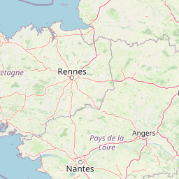
Map view of Réserve naturelle régionale de Basses-Brosses et Chevalleries

Use this park location map to pinpoint Réserve naturelle régionale de Basses-Brosses et Chevalleries in France, understand its exact geographic position, and read its mapped placement within the surrounding landscape more clearly.

Pigeon | © OpenStreetMap contributors

Location context for Réserve naturelle régionale de Basses-Brosses et Chevalleries

Pays de la Loire
Park atlas

Compare surrounding regional nature reserves and protected landscapes across western France

Parks Near Réserve naturelle régionale de Basses-Brosses et Chevalleries

Browse protected areas and regional reserves adjacent to Réserve naturelle régionale de Basses-Brosses et Chevalleries to examine similar bocage terrain, hedgerow networks, and wetland mosaics. Exploring nearby conservation landscapes reveals broader regional ecological patterns and connected habitat types throughout the Loire valley.
A soft watercolor illustration featuring a calm pond in the foreground, with reeds on the right and a distant treeline and rolling hills in the background.
Nature reservePays de la Loire
About 33 km away#1 closest

East

Réserve naturelle régionale des étang et boisements de Joreau: Protected Area Atlas Profile

Wetland and woodland mosaic in the Pays de la Loire region.

This profile examines the 92-hectare Réserve naturelle régionale des étang et boisements de Joreau, a protected area in the Maine-et-Loire department. The site features a specialized composition of freshwater ponds and mature woodlands, reflecting the traditional riverine landscapes found throughout the broader Loire Valley regional geography.

Area
0.92 km²
Established
2015
IUCN
IV
Nature reservePays de la Loire
About 42 km away#2 closest

West

Réserve naturelle régionale de la ferme de la Chauffetière: Geographic and Landscape Atlas

Protected nature reserve in the Pays de la Loire region

Spanning 30 hectares, the Réserve naturelle régionale de la ferme de la Chauffetière showcases the authentic Mauges bocage landscape. Its varied terrain includes humid valleys, dry calcareous slopes, and agricultural plateaus, providing essential habitat for amphibians, rare orchids, and saproxylic insects within a living, working farm environment.

Area
0.3 km²
Established
2008
IUCN
IV
Relief
Upland
Nature reservePays de la Loire
About 48 km away#3 closest

Northeast

Réserve naturelle régionale des marais de Cré-sur-Loir et La Flèche Protected Landscape

Wetland ecosystems in the Pays de la Loire region.

Spanning an old meander of the Loir river, this regional nature reserve preserves a complex network of marshes, canals, and alluvial forests. Learn about its unique floodplain geography and the protected wetland habitats that sustain regional biodiversity in the heart of the Sarthe department.

Area
0.531 km²
Established
2008
IUCN
IV
Relief
Lowland
Nature reservePays de la Loire
About 51 km away#4 closest

Southeast

Réserve naturelle régionale Champagne de Méron: Geographic and Protected Area Overview

A regional nature reserve within the Maine-et-Loire department.

Located in the heart of the Anjou countryside, Réserve naturelle régionale Champagne de Méron represents a strategic effort to safeguard biodiversity within western France. Covering 146 hectares, this protected area illustrates the intersection of modern conservation goals and historic rural landscapes, offering a clear view of how regional authorities manage and restore fragmented natural habitats.

Area
1.461 km²
Established
2023
IUCN
IV
Scope
Terrestrial
Nature reserveNouvelle-Aquitaine
About 55 km away#5 closest

Southeast

Réserve naturelle nationale du Toarcien: Protected Jurassic Stratotype and Geological Map

A vital paleontological heritage site in the Nouvelle-Aquitaine region

As the smallest national nature reserve in France, Réserve naturelle nationale du Toarcien provides a concentrated, scientifically essential view of Jurassic marine sediments. The protected quarries preserve ammonite-rich strata and complex geological unconformities, serving as the international definition for the Toarcian geological stage within the Thouet valley landscape.

Area
0.006 km²
Established
1987
IUCN
III
Relief
Lowland
Nature reserveNouvelle-Aquitaine
About 57 km away#6 closest

Southeast

Réserve naturelle régionale de la vallée du Pressoir: Protected Limestone Valley and Geoheritage

A rare natural and cultural mosaic in Nouvelle-Aquitaine

Trace the boundaries and natural features of the Réserve naturelle régionale de la vallée du Pressoir. This protected site in the Deux-Sèvres department is defined by thin calcareous soils, the historic Pommiers cascade, and fossil-rich limestone outcrops that form an unusual geoheritage landscape.

Area
0.56 km²
Established
2025
IUCN
IV
Visitors
10K annual
Nature reservePays de la Loire
About 64 km away#7 closest

Northeast

Réserve naturelle régionale du coteau et prairies des Caforts: Protected Area and Map Atlas

A diverse protected landscape in the Pays de la Loire region

Situated in the Loir valley, this regional nature reserve combines three distinct landscape types: dry limestone slopes, humid hay meadows, and 910 meters of man-made tuffeau quarry galleries. The site represents a significant pocket of biodiversity, hosting sixteen bat species and rare flora within its compact protected footprint in Sarthe.

Area
0.064 km²
Established
2009
IUCN
IV
Nature reservePays de la Loire
About 66 km away#8 closest

West

Réserve naturelle régionale de la tourbière de Logné: Protected Wetland Landscape Map

A rare peatland refuge in the Pays de la Loire administrative region

Located on the outskirts of Nantes, the Réserve naturelle régionale de la tourbière de Logné protects a delicate raised bog system. This atlas entry provides a detailed look at the basin terrain, its surrounding hills, and the wetland connectivity that supports its status as a critical botanical and invertebrate sanctuary within the Erdre valley.

Area
0.706 km²
Established
2011
IUCN
IV

Common questions about visiting, size, designation, and location context for Réserve naturelle régionale de Basses-Brosses et Chevalleries

Réserve naturelle régionale de Basses-Brosses et Chevalleries FAQs for park facts, access, geography, and protected area context

Find quick answers about Réserve naturelle régionale de Basses-Brosses et Chevalleries, including protected-area facts, park geography, trail and visitor context, and how the park fits into its surrounding country and regional landscape.
MoriAtlas Explorer

Continue Your Protected Areas Search Across the Global Atlas

Deepen your exploration by continuing the structured search for national parks and protected areas worldwide. Utilize the comprehensive filtering capabilities to compare different conservation landscapes and refine your understanding of global park geography. Discover more about the distribution and characteristics of protected natural areas.

Global natural geography