Mori Atlas logo
Nature reserveRéserve naturelle régionale de la grotte de Beaumotte

Examining the subterranean ecology, karst landscape, and bat conservation network of this protected regional site.

Réserve naturelle régionale de la grotte de Beaumotte: A Specialized Limestone Cave and Subterranean Nature Reserve in Eastern France

The Réserve naturelle régionale de la grotte de Beaumotte represents a crucial protected landscape within the limestone massifs of the Bourgogne-Franche-Comté region. This specialized nature reserve is centered on a subterranean gallery network carved through Jurassic limestones, providing essential habitat for migratory bat species. Discover the geographic and ecological significance of this small but highly defined protected karst site, which stands as a model for coordinated regional underground conservation.

regional nature reservecave habitatsubterranean ecologychiropterabat conservationlimestone cave

Réserve naturelle régionale de la grotte de Beaumotte

Nature reserve

Park overview

Structured park overview, official facts, and landscape profile for Réserve naturelle régionale de la grotte de Beaumotte

Réserve naturelle régionale de la grotte de Beaumotte park facts, protected area profile, and essential visitor context

Review the core facts for Réserve naturelle régionale de la grotte de Beaumotte, including designation, size, terrain, visitor scale, habitats, and operating context in one park-focused overview.

About Réserve naturelle régionale de la grotte de Beaumotte

The Réserve naturelle régionale de la grotte de Beaumotte represents a distinctive model of French regional nature reserve: a designation built around a single subterranean habitat of high biological value rather than a conventional terrestrial landscape. Located on the commune of Beaumotte-lès-Pin in Haute-Saône, the reserve occupies a tiny footprint around a natural cave developed in Jurassic limestones and marls of the Séquanien stage. Although only a few hectares in extent, the site carries disproportionately high conservation importance because of its role for cave-dwelling bats, a group that has suffered severe declines across much of Europe.

The cave opens at the base of a small limestone cliff, marking the upstream end of a shallow valley where a captured spring gives rise to a stream. From this entrance, the cavity extends horizontally into multiple galleries tens of meters in length, forming a stable underground environment characterized by darkness, humidity, and relatively constant temperatures. These conditions are precisely what make the cave suitable for hibernating bats and for the spring and autumn transits of cave-dependent species such as Schreibers' long-fingered bat.

At a regional scale, the reserve belongs to a coordinated network of caves set up to safeguard the underground habitats needed by bats across their annual cycle. This collective approach reflects a broader shift, beginning in the early 2000s, in how France conserves subsoil biodiversity: regional authorities have taken responsibility for what were once volunteer reserves, and specialist bat conservation organizations such as the CPEPESC Franche-Comté now administer these protected sites. The Beaumotte cave exemplifies how a small, fragile, and quiet site can nonetheless contribute to a much larger strategy for the long-term survival of cave-roosting species in eastern France.

Quick facts and research context for Réserve naturelle régionale de la grotte de Beaumotte

The Réserve naturelle régionale de la grotte de Beaumotte is a regional nature reserve (RNR) classified on 24 September 2015 in the Bourgogne-Franche-Comté region, France. It covers approximately 8.83 hectares within the Haute-Saône department, on the commune of Beaumotte-lès-Pin. The protected site is centered on a natural limestone cave rather than on a broad landscape, which explains its unusually small surface area.

It is managed by the CPEPESC Franche-Comté, a regional commission dedicated to water protection, natural heritage, the subsoil, and bats in particular. The site also benefits from complementary protections, including a ZNIEFF designation, a Natura 2000 Special Area of Conservation linked to Schreibers' long-fingered bat caves, and a prefectoral biotope protection order dating from 2007. Together, these tools make it one of several sites in a coordinated regional network of bat caves protected across Franche-Comté.

Protection and recognition

Documented terrestrial protection scope, designation year, and management records

Protection Status and Designation History for Réserve naturelle régionale de la grotte de Beaumotte

Terrestrial protection status for Réserve naturelle régionale de la grotte de Beaumotte includes a documented designation established in 2015. Structured conservation records outline the official management scope and protected area administration details.

Protection details

Protection scope
Terrestrial
Designated year
2015
Transboundary protection
No
WDPA ID
555597285
Park context

Deeper park guide and search-rich context for Réserve naturelle régionale de la grotte de Beaumotte

Réserve naturelle régionale de la grotte de Beaumotte history, landscape, wildlife, and travel context

Explore Réserve naturelle régionale de la grotte de Beaumotte through its history, landscape character, ecosystems, wildlife, conservation priorities, cultural context, and seasonal travel timing in a structured park guide built for atlas discovery and search intent.

Why Réserve naturelle régionale de la grotte de Beaumotte stands out

The reserve is known above all for the exceptional value of its underground habitat, especially for cave-dwelling bats. It is part of a network of caves in Franche-Comté used by Schreibers' long-fingered bat throughout its annual life cycle, which includes spring and autumn transits and winter hibernation. Hibernation sites in the cave support several bat species of regional concern, such as the greater horseshoe bat and Geoffroy's bat. The cave's horizontal galleries, developed in Jurassic limestones, provide the cool, stable, dark conditions required by these sensitive species. The reserve is therefore recognized as much for its ecological role within a broader bat conservation network as for its surface area.
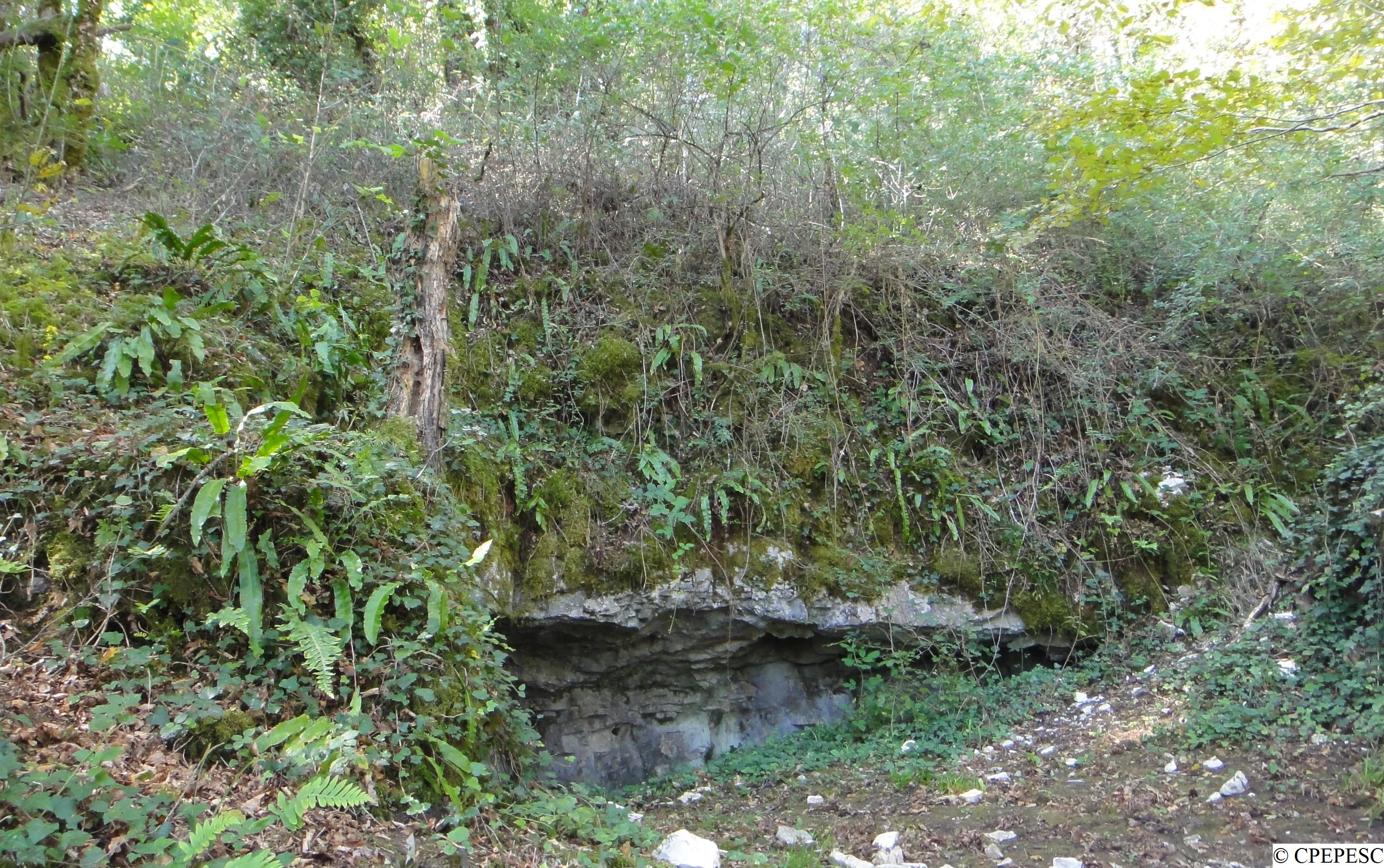
A low, dark cave entrance hidden beneath an earthen bank covered in moss, ferns, and small trees in a forest setting.
The entrance to the Grotte de Beaumotte, a protected cave habitat.

Réserve naturelle régionale de la grotte de Beaumotte history and protected-area timeline

The protection history of the Grotte de Beaumotte is closely tied to the evolution of France's framework for regional nature reserves and the conservation of cave-dwelling bats. In 2002, the law known as "Démocratie de proximité" transferred new environmental responsibilities to French regions while simultaneously ending the legal status of voluntary nature reserves. As a result, three sites important for bats lost their earlier designation.

In response, the CPEPESC Franche-Comté worked with the former Franche-Comté region to assess the feasibility of creating a new framework of regional nature reserves specifically dedicated to bat caves and their habitats. This planning process culminated in 2015 and 2017 with the legal classification of seven caves, including the Grotte de Beaumotte, which received its RNR status by decision of the Regional Council on 24 September 2015. The CPEPESC Franche-Comté was formally designated as manager of this cave network by orders issued in October 2015 and December 2017.

Prior to its RNR classification, the cave had already been protected by a prefectoral biotope protection order (APPB) issued in December 2007, recognizing its ecological sensitivity. After the reserve's creation, a unified management plan covering the entire bat cave network was adopted in September 2019, outlining around 70 conservation actions aimed primarily at safeguarding habitat function for six priority bat species over a five-year cycle.

Réserve naturelle régionale de la grotte de Beaumotte landscape and geographic character

The reserve sits on the edge of the Monts de Gy, a modest limestone massif in Haute-Saône that lies between the broader valleys of the Saône to the west and the Ognon to the east. This part of eastern France belongs to the Jurassic limestone belt of Bourgogne-Franche-Comté, a setting that produces relatively low but well-defined karst terrain with cliffs, small crests, and concealed valleys.

At the site itself, the visible landscape is subtle. A modest limestone cliff, or cran rocheux, marks the entrance to the cave and frames the upper end of a small valley where a captured spring feeds the headwaters of a stream. The cave then continues underground as a roughly horizontal network of galleries cut through the Jurassic limestones and marls of the Séquanien stage.

Because the reserve is structured around a subterranean feature rather than open countryside, its surface area is unusually small, approximately 8.83 hectares. The dramatic appearance of the landscape lies beneath the surface, in the form of cave passages whose cool, stable, humid conditions define the character of the protected site.

Réserve naturelle régionale de la grotte de Beaumotte ecosystems, habitats, and plant life

The dominant ecological character of the reserve is subterranean. The cave provides the stable microclimate that supports cave-dwelling bats throughout their annual cycle, while the very small surface envelope above ground offers a buffer against disturbance to the entrance and the surrounding vegetation that influences humidity and air circulation within the cavity.

On the surface, the wooded parcel and the limestone cliff at the entrance contribute a mosaic of small habitats typical of the southern Monts de Gy area. These include dry calcareous vegetation on the cliff face, deciduous woodland, and spring-fed riparian vegetation associated with the small stream issuing from the captured source. Together, these elements create a sheltered setting that helps preserve the integrity of the cave entrance.

At a broader level, the reserve forms part of an interconnected ecological network of caves recognized for bat conservation in Franche-Comté. This network is intentionally designed to ensure that critical functions, including hibernation, transits between seasonal sites, and maternity, can be maintained across a regional landscape where no single site can meet all the needs of a colony.

Réserve naturelle régionale de la grotte de Beaumotte wildlife and species highlights

The wildlife focus of the reserve is strictly and deliberately centered on bats. Eleven species, or species groups, regularly use the Grotte de Beaumotte, with several presence patterns closely tied to the annual cycle of cave-dwelling species.

The most emblematic species is Schreibers' long-fingered bat (Miniopterus schreibersii), a highly social cave-roosting species that can form colonies numbering in the hundreds. In the Beaumotte cave, transiting groups can reach around 400 individuals during the spring and autumn movement periods, when bats travel between seasonal roosts. The cave is also used during hibernation by species such as the greater horseshoe bat (Rhinolophus ferrumequinum) and Geoffroy's bat (Myotis emarginatus), both of which require the cool, stable, and undisturbed conditions that the cave provides.

The wider network of which the reserve is part identifies six priority species for conservation, including Schreibers' long-fingered bat, the lesser mouse-eared bat, the Mediterranean horseshoe bat, the greater horseshoe bat, the lesser horseshoe bat, and Geoffroy's bat. Together, these species represent the main faunal justification for the site's protection, and their continued presence indicates that the cave remains functional as a seasonal refuge within the regional landscape.

Réserve naturelle régionale de la grotte de Beaumotte conservation status and protection priorities

The Grotte de Beaumotte is a protected site of considerable conservation value despite its tiny size. Its importance lies in its function as a seasonal refuge for cave-dwelling bats, a faunal group that has experienced significant declines in Europe due to disturbance of underground sites, habitat fragmentation, and the loss of foraging habitats. The reserve's tightly regulated protection is built around the principle that even minor disturbances inside a bat cave can cause direct mortality or force animals to abandon a site in favor of poorer-quality alternatives.

The reserve layers multiple legal protections. A prefectoral biotope protection order issued in December 2007 secured the cave's basic protection as a bat hibernation site, while the RNR classification of September 2015 strengthened its conservation status and provided a formal manager and a long-term framework. At the European level, the site falls within a Natura 2000 Special Area of Conservation dedicated to the network of caves used by Schreibers' long-fingered bat, placing it in a continent-wide conservation context.

At the regional scale, the site's conservation value is inseparable from the broader network. CPEPESC Franche-Comté, which manages a series of bat caves across the former Franche-Comté region, treats the Beaumotte cave as one node in a system designed to ensure that critical functions such as hibernation and transits remain available over time. The unified management plan approved in 2019, with nearly 70 actions, reflects this network-based approach and positions the reserve as a key component in the long-term survival of cave-dependent species in Bourgogne-Franche-Comté.

Réserve naturelle régionale de la grotte de Beaumotte cultural meaning and human context

The Grotte de Beaumotte and its surroundings belong to a region with deep karst and limestone heritage, where caves have long been used for shelter, water supply, and folklore. The presence of a captured spring at the cave entrance, with a small stream issuing from it, underscores the historical relationship between underground water systems and rural land use in the Franche-Comté countryside.

The site's modern cultural significance is more institutional than traditional. It reflects the role of regional civil society organizations, especially the CPEPESC Franche-Comté, in shaping the conservation identity of eastern France. The reserve's strict access regime, with public entry limited to a short mid-summer window, is itself a form of cultural practice, embedding the cave into a contemporary framework of ecological stewardship and citizen-led nature protection.

Top sights and standout views in Réserve naturelle régionale de la grotte de Beaumotte

A small but ecologically concentrated regional nature reserve in Haute-Saône, the Grotte de Beaumotte is centered on a Jurassic limestone cave that supports an exceptional bat fauna. Its most striking highlight is the presence of a transiting population of up to 400 Schreibers' long-fingered bats during spring and autumn movements, alongside several rare or sensitive species that hibernate within the cave's horizontal galleries.

Equally notable is the layered legal protection of the site, which combines a regional nature reserve, a prefectoral biotope order, a Natura 2000 designation for caves used by Schreibers' long-fingered bat, and a unified network-management approach spanning multiple caves in Franche-Comté. Together, these features make the Grotte de Beaumotte a model of how a single subterranean site can contribute to a coordinated, region-wide bat conservation strategy.

Best time to visit Réserve naturelle régionale de la grotte de Beaumotte

Because the reserve exists to protect an extremely sensitive underground habitat, public access to the cave is allowed only during a narrow summer window, generally from 1 July to 15 August, and only with prior authorization from the commune of Beaumotte-lès-Pin. Outside this period, the cave remains closed to visitors so that hibernating and transiting bats are not disturbed.

For visitors interested in the surrounding landscape rather than the cave interior itself, the broader limestone landscapes of the Monts de Gy between the Saône and Ognon valleys are best appreciated in late spring and early autumn, when mild temperatures and quieter conditions suit gentle walks and landscape observation. Any outdoor visit should remain on the surface and respect the regulatory framework that protects the underground environment.

Monthly climate preview

Long-term temperature ranges and monthly precipitation records measured across twelve representative months

Réserve naturelle régionale de la grotte de Beaumotte Climate Normals and Annual Weather Patterns

Representative coordinates record average monthly temperatures spanning from sub-zero winter minimums to warm summer maximums alongside steady daily precipitation normals. Analyzing the complete monthly profile provides deeper insight into long-term meteorological trends governing the protected terrain.
Annual mean10 °C
1 °C19 °C
Jan
Feb
Mar
Apr10°
May14°
Jun17°
Jul19°
Aug19°
Sep15°
Oct11°
Nov
Dec
Warmest month
July

19.3 °C

Coolest month
January

1.3 °C

Wettest month
November

3 mm/day

Driest month
March

2 mm/day

Park location guide

Geography guide, regional context, and park location map for Réserve naturelle régionale de la grotte de Beaumotte

Réserve naturelle régionale de la grotte de Beaumotte park geography, regions, and map view in France

Understand where Réserve naturelle régionale de la grotte de Beaumotte sits in France through a broader geographic reading of the surrounding landscape, nearby location context, and its mapped position within the national park landscape.

How Réserve naturelle régionale de la grotte de Beaumotte fits into France

France is a unitary semi-presidential republic and one of the world's largest economies. It borders Belgium, Luxembourg, Germany, Switzerland, Italy, Monaco, Andorra, and Spain, with a maritime border to the United Kingdom. The country is known for its cultural influence, art, cuisine, and political history spanning centuries.

Wider geography shaping Réserve naturelle régionale de la grotte de Beaumotte in France

France is located in Western Europe. Metropolitan France extends from the Rhine to the Atlantic Ocean and from the Mediterranean Sea to the English Channel and North Sea. The country borders Belgium, Luxembourg, Germany, Switzerland, Italy, Monaco, Andorra, Spain, and has a maritime border with the United Kingdom.

Map view of Réserve naturelle régionale de la grotte de Beaumotte

Use this park location map to pinpoint Réserve naturelle régionale de la grotte de Beaumotte in France, understand its exact geographic position, and read its mapped placement within the surrounding landscape more clearly.

Pigeon | © OpenStreetMap contributors

Location context for Réserve naturelle régionale de la grotte de Beaumotte

Bourgogne-Franche-Comté

Visual reference collection highlighting surface karst terrain, limestone cliffs, and subterranean habitats

Réserve naturelle régionale de la grotte de Beaumotte photos, landscape views, and limestone cave scenery

Visual records capture the distinctive limestone cliff entrance and karst terrain surrounding Réserve naturelle régionale de la grotte de Beaumotte. Protected area photography reveals the subtle surface topography of the Monts de Gy alongside the ecological context of the subterranean habitats.

A low, dark cave entrance hidden beneath an earthen bank covered in moss, ferns, and small trees in a forest setting.

Park atlas

Compare adjacent subterranean habitats and limestone landscapes across eastern France

Parks Near Réserve naturelle régionale de la grotte de Beaumotte and Surrounding Regional Protected Areas

Browsing other protected areas near Réserve naturelle régionale de la grotte de Beaumotte reveals broader regional conservation networks across the Jurassic limestone belt. Comparing nearby karst landscapes provides essential context for understanding specialized subterranean ecosystems and regional bat habitats.
A soft watercolor painting of a green, hilly landscape with small groups of trees, set against a white background.
Nature reserveBourgogne-Franche-Comté
About 7.8 km away#1 closest

Northeast

Réserve naturelle régionale du vallon de Fontenelay: Protected Area Atlas and Map

High-density marly grasslands and wetland seepage slopes

Situated in the Haute-Saône department, this nature reserve features a distinct valley landscape formed by marly soil and limestone. Explore the site's rich biodiversity including alkaline marshes and its significant role in the regional conservation network for northeastern France.

Area
0.416 km²
Established
2010
IUCN
IV
Relief
Upland
Nature reserveBourgogne-Franche-Comté
About 17 km away#2 closest

Northeast

Réserve naturelle régionale de la grotte de la Baume noire Protected Area Map and Geography

Regional karst landscape in Bourgogne-Franche-Comté

This 19-hectare reserve in the Monts de Gy is defined by its Jurassic limestone geology and protected cave systems. The site remains a primary focal point for monitoring subterranean bat habitats and maintaining the ecological integrity of the surrounding deciduous forest landscape.

Area
0.191 km²
Established
2015
IUCN
IV
Relief
Upland
Nature reserveBourgogne-Franche-Comté
About 21 km away#3 closest

South

Réserve naturelle régionale du gouffre du Creux à Pépé: Protected Karst and Bat Landscapes

Jura foothills nature reserve with critical cave habitats

Located in the Doubs department, the Réserve naturelle régionale du gouffre du Creux à Pépé protects a rare limestone sinkhole within a mosaic of dry calcareous grassland. This site stands as a key node in regional bat conservation efforts, providing essential wintering and spring transit roosts within the Jura mountain foothills, all anchored by a dense network of biotope and Natura 2000 protective instruments.

Area
0.007 km²
Established
2015
IUCN
IV
Relief
Upland
Watercolor painting of a hilly landscape featuring green rolling hills, a rocky cliff formation to the right, and trees against a soft white background.
Nature reserveBourgogne-Franche-Comté
About 24 km away#4 closest

Southeast

Réserve naturelle régionale des grottes de Chenecey: Protected Karst and Limestone Cliffs

Regional Nature Reserve in the Doubs, France

This nature reserve protects a diverse mosaic of habitats along the Loue valley. The site integrates surface calcareous grasslands with fragile underground cave galleries, providing critical refuge for rare bat species. It represents a significant conservation effort in the Jura region, mapping the intersection of subterranean voids and exposed limestone terrain.

Area
0.214 km²
Established
2017
IUCN
IV
Relief
Upland
A horizontal watercolor painting depicting a soft-edged, green-and-white landscape of rolling hills and distant limestone ridgelines.
Nature reserveBourgogne-Franche-Comté
About 34 km away#5 closest

Southeast

Réserve naturelle nationale du ravin de Valbois: Protected Jura Blind Valley and Limestone Ravines

Geographic landscape exploration of the Doubs department's protected natural reserve.

Spanning 235 hectares, this protected nature reserve in Bourgogne-Franche-Comté preserves a textbook Jura reculée. The terrain showcases vertical limestone cliffs, deep forested ravines, and a 40-meter cascade. As a hotspot for butterfly diversity and Mediterranean-montane vegetation, the area offers a significant study in microclimatic gradients and old-growth forest conservation within the French landscape.

Area
2.35 km²
Established
1983
IUCN
IV
Relief
Mountain
Nature reserveBourgogne-Franche-Comté
About 37 km away#6 closest

Northeast

Réserve naturelle régionale de la grotte de la Baume: Regional Nature Reserve Atlas

Mapping karst cave systems and bat habitats in Haute-Saône

The Réserve naturelle régionale de la grotte de la Baume protects a limestone cave system on the edge of the plateau near Échenoz-la-Méline. Its small but intensive protected perimeter serves as a vital hibernation site and autumn transit corridor, forming part of a broader ecological network across the Franche-Comté landscape.

Area
0.175 km²
Established
2015
IUCN
IV
Relief
Upland
A horizontal watercolor painting showing a soft, impressionistic landscape with layers of green hills and trees against a pale, light background.
Nature reserveBourgogne-Franche-Comté
About 41 km away#7 closest

Northeast

Réserve naturelle nationale du Sabot de Frotey: Geographic and Protected Area Overview

Limestone plateau and calcareous grasslands in Haute-Saône

Located near Vesoul, the Réserve naturelle nationale du Sabot de Frotey features a prominent southwest-facing cliff and a rich expanse of dry grassland. This nature reserve provides critical habitat for orchids and diverse butterfly assemblages within a landscape defined by erosion-shaped monoliths and Mediterranean-edge flora.

Area
0.98 km²
Established
1981
IUCN
IV
Relief
Upland
Nature reserveBourgogne-Franche-Comté
About 44 km away#8 closest

East

Réserve naturelle régionale des Grottes du Cirque: Regional Nature Reserve and Karst Network

Protected limestone valley and bat hibernation site in Bourgogne-Franche-Comté

Located in the pre-Jura hills, this regional nature reserve features a compact reculée landscape defined by six limestone caves. These protected underground habitats serve as vital wintering grounds for various bat species and contain significant prehistoric fossil remains, marking the site as a key area for both geological and ecological study in eastern France.

Area
0.153 km²
Established
2015
IUCN
IV
Relief
Upland

Common questions about visiting, size, designation, and location context for Réserve naturelle régionale de la grotte de Beaumotte

Réserve naturelle régionale de la grotte de Beaumotte FAQs for park facts, access, geography, and protected area context

Find quick answers about Réserve naturelle régionale de la grotte de Beaumotte, including protected-area facts, park geography, trail and visitor context, and how the park fits into its surrounding country and regional landscape.
MoriAtlas Explorer

Continue Your Protected Areas Search Across the Global Atlas

Deepen your exploration by continuing the structured search for national parks and protected areas worldwide. Utilize the comprehensive filtering capabilities to compare different conservation landscapes and refine your understanding of global park geography. Discover more about the distribution and characteristics of protected natural areas.

Global natural geography