
Mori Atlas logo
Nature reserveRéserve naturelle nationale du ravin de Valbois

Mapping the dramatic vertical relief, microclimatic gradients, and rare biodiversity of a classic French blind valley.

Réserve naturelle nationale du ravin de Valbois: Protected Jura Reculée and Limestone Landscapes

The Réserve naturelle nationale du ravin de Valbois protects a classic Jura reculée, a deep, amphitheater-like blind valley carved into the limestone plateau of the Doubs department. This site in Bourgogne-Franche-Comté spans 235 hectares and features striking vertical relief, including limestone cliffs and a 40-meter waterfall. The mapped terrain reveals sharp microclimatic contrasts between sun-exposed grassland ledges and humid, forested ravine floors, fostering an environment for rare montane flora and exceptional insect diversity.

Jura reculéelimestone cliffsdry grasslandcalcareous screeold-growth forestbutterfly diversity
A flat-style digital illustration depicting a river winding through a valley flanked by tall limestone cliffs under a sunrise sky.

Réserve naturelle nationale du ravin de Valbois

Nature reserve

Park overview

Structured park overview, official facts, and landscape profile for Réserve naturelle nationale du ravin de Valbois

Réserve naturelle nationale du ravin de Valbois park facts, protected area profile, and essential visitor context

Review the core facts for Réserve naturelle nationale du ravin de Valbois, including designation, size, terrain, visitor scale, habitats, and operating context in one park-focused overview.

About Réserve naturelle nationale du ravin de Valbois

The Réserve naturelle nationale du ravin de Valbois protects a representative and unusually rich fragment of the upper Loue valley landscape, focused on a classic Jura reculée. The ravine cuts deeply into the first plateau of the Jura massif, exposing a complete stratigraphic sequence from the Bathonian up to the Sequanian. At its base lies the impermeable Oxfordian clay, which has been incised by erosion into a closed amphitheater-like form typical of the region, with sheer Rauracian limestone cliffs on the rim and unstable scree slopes on the flanks. From the plateau edge, the Valbois stream plunges in a 40-meter cascade into the ravine floor before eventually joining the Loue downstream of Scey-en-Varais.

The reserve's compact size belies its ecological richness, because the reculée concentrates an unusual range of microclimates. South-facing cliffs and ledges support xerophilic Mediterranean-montane vegetation such as mountain kidney-vetch, rock buckthorn, autumn lady's-tresses, and branched thesium. The shaded, humid floor of the ravin hosts montane relict species including Alpine adenostyle, lesser wintergreen, and common butterwort, along with a rich bryophyte flora that includes the regionally protected moss Tortella nitida. Rock faces and scree host the intermediate candytuft Iberis intermedia, a regionally notable species. The combination of dry cliff, scree, and humid valley within such a short distance is the defining feature of the site.

The reserve is also an important cultural landscape. Until the late nineteenth century, the warm south-facing slopes were covered with vineyards, as in much of the Loue valley. The phylloxera crisis and the broader rural decline of the twentieth century ended viticulture here, and agricultural abandonment allowed forest to recolonize almost the entire reserve. Today, two forest parcels have not been exploited since 1910, creating pockets of old-growth woodland with abundant deadwood and a markedly different atmosphere from the surrounding production forest. The reserve sits at the heart of a broader protected-area mosaic, including the ZNIEFF of the upper Loue valley, a Natura 2000 Special Area of Conservation, and the classified historic site of the Château Saint-Denis ruins perched above the ravine entrance.

Quick facts and research context for Réserve naturelle nationale du ravin de Valbois

The Réserve naturelle nationale du ravin de Valbois is a French national nature reserve (Réserve naturelle nationale, code RNN66) established on 26 October 1983. It lies in the Doubs department within the Bourgogne-Franche-Comté region, spanning the communes of Cléron and Chassagne-Saint-Denis, and sits within the Natura 2000 network of the upper Loue and Lison valleys. The reserve protects a Jura reculée, a steep limestone ravine roughly 3 km long between 330 and 550 meters of altitude.

Its surface is approximately 235 hectares (the founding decree cites 335 ha, while modern GPS measurements show about 234 ha in flat projection). The site belongs to the Laura Jullié plateau complex of the first Jura plateau. It is jointly protected as a ZNIEFF and a Natura 2000 Special Area of Conservation, and overlaps with the classified site of the Château Saint-Denis ruins.

Protection and recognition

Documented terrestrial protection scope, 1983 establishment year, and international records

Protection Status and Designation History for Réserve Naturelle Nationale du Ravin de Valbois

Terrestrial protection status for Réserve naturelle nationale du ravin de Valbois reflects documented designation history established in 1983. Official records compile administrative management scope and protected area data without international recognition sources.

Protection details

Protection scope
Terrestrial
Designated year
1983
Transboundary protection
No
WDPA ID
39788
Park context

Deeper park guide and search-rich context for Réserve naturelle nationale du ravin de Valbois

Réserve naturelle nationale du ravin de Valbois history, landscape, wildlife, and travel context

Explore Réserve naturelle nationale du ravin de Valbois through its history, landscape character, ecosystems, wildlife, conservation priorities, cultural context, and seasonal travel timing in a structured park guide built for atlas discovery and search intent.

Why Réserve naturelle nationale du ravin de Valbois stands out

The reserve is best known as one of France's premier sites for butterfly diversity, with more than 700 recorded species, including rare taxa such as the Dryad and the Woodland Brown. It is equally recognized for its reculée landscape, a deep, amphitheater-like limestone ravine formed by erosion of the Oxfordian clays beneath Rauracian cliffs, creating a dramatic microclimatic gradient within a very small area. The site is also valued for the striking coexistence of Mediterranean-montane plants in its sunny cliff grasslands and montane species such as Alpine Adenostyle, common butterwort, and lesser wintergreen in the cool, humid ravine floor. These ecological contrasts, combined with old-growth forest tracts that have not been exploited since the early twentieth century, give the reserve a strongly distinctive scientific profile.
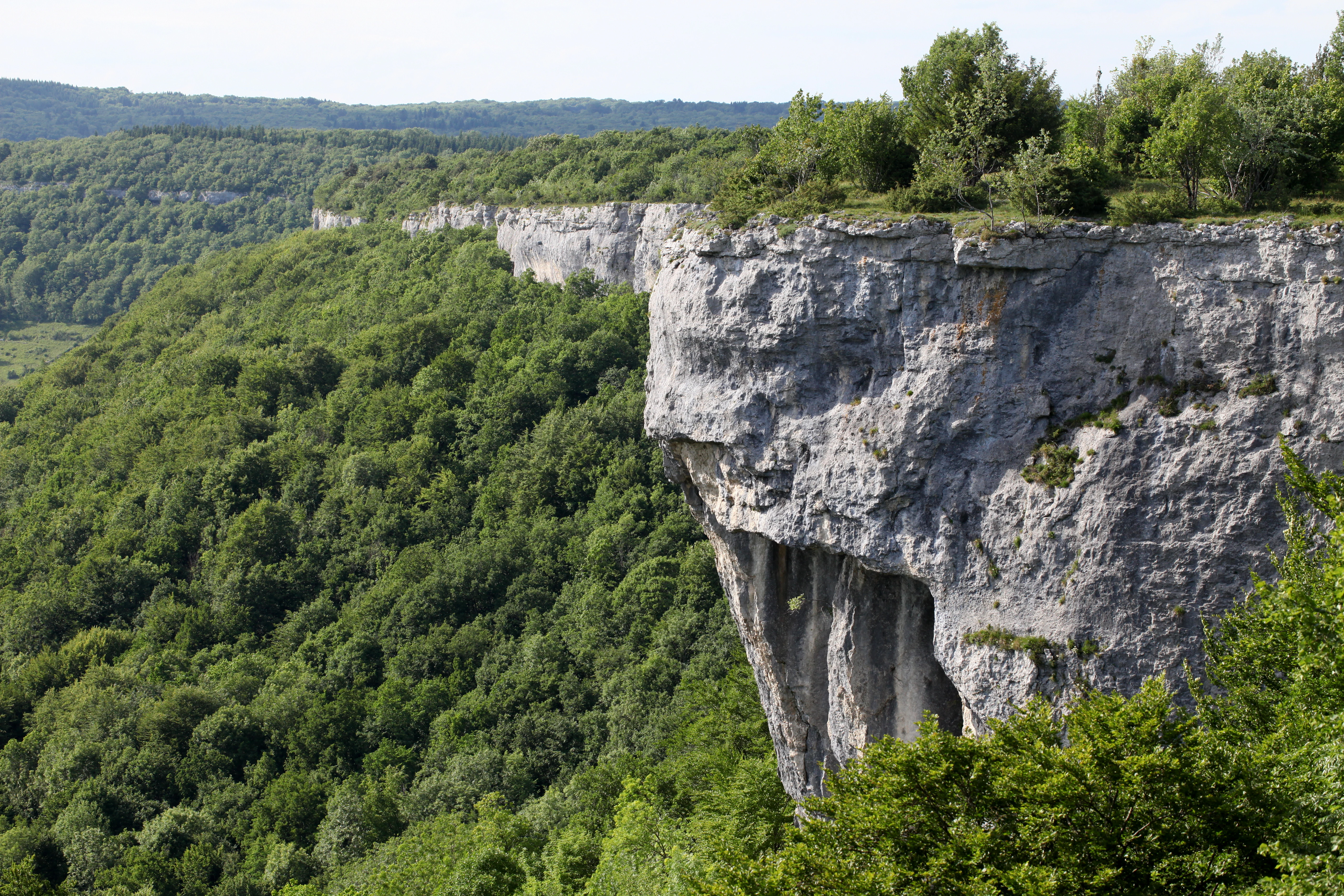
A steep, rugged limestone cliff rises above a dense forest in the Valbois ravine, with green trees covering the slopes.
A prominent limestone cliff face overlooking the wooded ravine of Valbois.

Réserve naturelle nationale du ravin de Valbois history and protected-area timeline

The valley of Valbois has a long human history tied to viticulture and rural land use. Like much of the upper Loue valley, its south-facing slopes were covered with vineyards until the end of the nineteenth century. The phylloxera epidemic devastated these traditional vineyards, and the parallel development of long-distance transport, which brought cheaper wines from southern France, ended the local wine-growing economy. Combined with the broader rural exodus of the twentieth century, this triggered rapid agricultural abandonment and the spread of scrub and forest across the slopes. Some former open areas were later conifer-planted, small traces of which survive today, but forest now covers most of the reserve.

The site's ecological value began to attract scientific interest in the early twentieth century, when botanists noted the unusual Mediterranean-montane plants growing on the cliff-top dry grasslands. By the 1970s, the exceptional insect diversity, especially among butterflies, had become a strong argument for formal protection, and a protection dossier was prepared by the Faculty of Sciences at Besançon. In 1983, the owner of about 90 percent of the territory supported the project, and the reserve was formally created by decree on 26 October 1983.

Between 1984 and the end of 2013, the reserve was administered by the Fédération de protection de la nature et de l'environnement du Doubs. Since 1 January 2014 it has been managed by the Conservatoire d'espaces naturels de Franche-Comté. The reserve has been guided by a sequence of management plans covering 1995 to 1999, 2005 to 2009, and 2011 to 2015, with successive plans validated by the regional scientific council for natural heritage (CSRPN) and the Doubs prefecture. The site is also layered with other protections, including ZNIEFF designations, the Natura 2000 zone of the upper Loue valley, the 1979 inscribed site of the upper Loue valley, and the historic monument listing of the Château Saint-Denis ruins above the ravine.

Réserve naturelle nationale du ravin de Valbois landscape and geographic character

The defining feature of the reserve is a reculée, one of the characteristic blind-valley landforms of the Jura massif, formed where surface and underground erosion have cut a deep amphitheater into the first plateau. The recess extends for roughly 3 km along the valley axis and rises from about 330 m at the Loue side to about 550 m at the plateau edge, a vertical relief of more than 200 m concentrated into a very small area. At its lower end, the ravine opens abruptly onto the upper Loue valley near Cléron, with the ruins of the Château Saint-Denis perched dramatically at the rim.

The cliffs are cut in the hard Rauracian limestone, the middle slopes expose the softer Argovian and Oxfordian beds, and the impermeable Oxfordian clay at the base has allowed runoff water and mass wasting to excavate the hollow. Unstable scree slopes cling to the flanks, while the ravine floor is a narrow band of humid valley bottom cut by the Valbois stream. Where the stream tumbles over the plateau edge, it forms a 40-meter cascade that is one of the most recognizable features of the site.

The microtopography creates striking local contrasts. South-facing cliff ledges and screes are sun-baked and dry, while the shaded north-facing slopes and the ravine floor retain moisture and cool air for much of the year. The result is a mosaic of dry limestone grassland, warm cliff vegetation, conifer-afforested slopes, beech-dominated forest, moist valley-bottom thickets, and the rocky stream corridor itself. Two forest parcels have not been exploited since the early twentieth century, so they retain old trees and substantial amounts of standing and fallen deadwood, giving parts of the reserve a natural-forest character that contrasts with the surrounding managed woodlands.
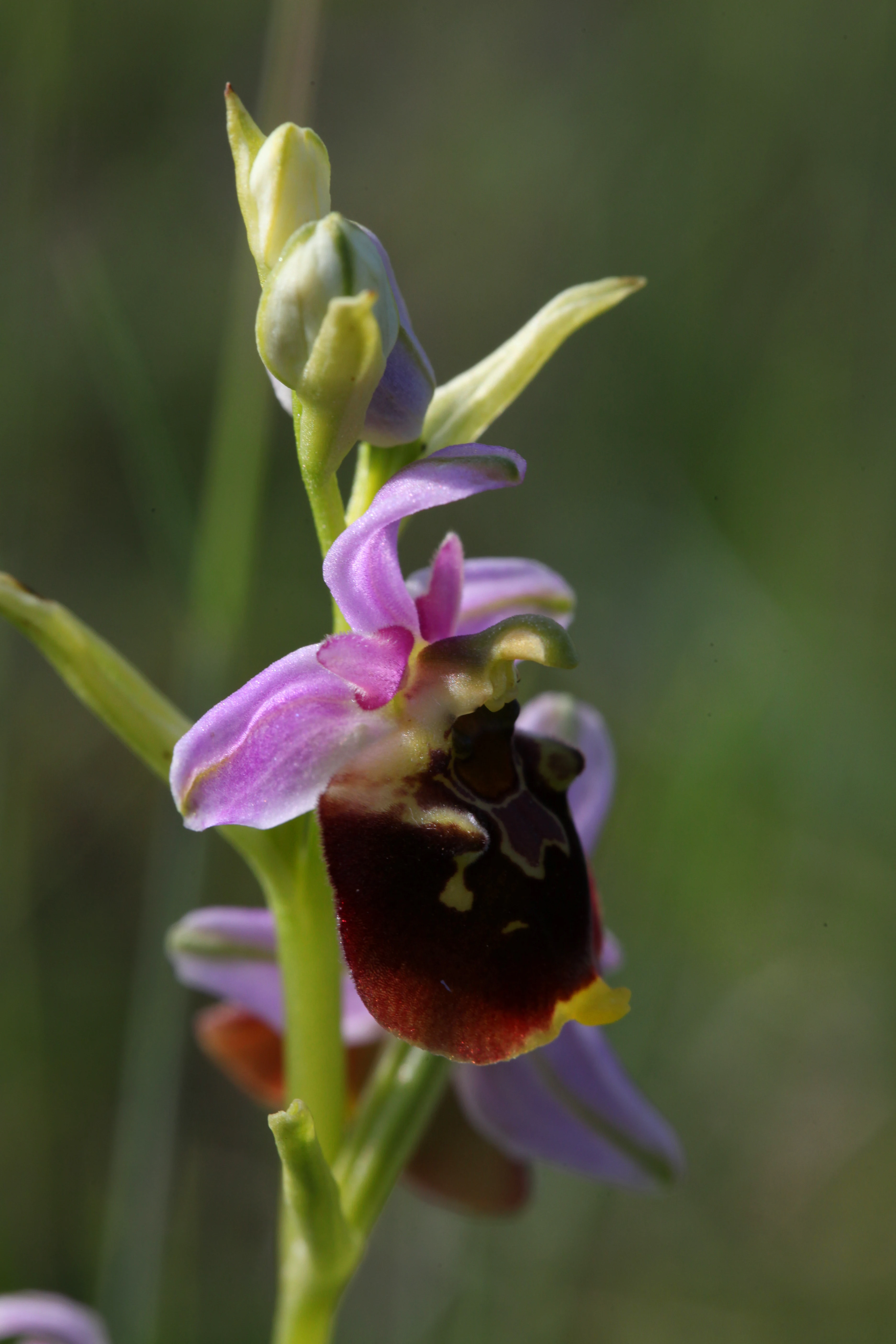
A close up, vertical shot of a single late spider orchid showing its pink petals and distinctive dark, patterned labellum against a soft, green out of focus background.
A close up view of a late spider orchid in the Valbois ravine.

Réserve naturelle nationale du ravin de Valbois ecosystems, habitats, and plant life

The reserve's ecological identity is defined by the juxtaposition of contrasting habitats within a very small area, a direct consequence of the reculée topography. On the south-facing cliff-top dry grasslands, the most xerophilic vegetation includes mountain kidney-vetch, rock buckthorn, autumn lady's-tresses, and branched thesium, species that mark the Mediterranean-montane character of the site. Rock faces and scree slopes host intermediate candytuft and an interesting bryoflora, including the regionally protected moss Tortella nitida. These open habitats are the most botanically distinctive in the reserve.

The ravine floor and shaded slopes form an almost inverted ecological world. The cool, humid valley bottom has allowed montane plants to persist at relatively moderate altitude, including Alpine adenostyle, lesser wintergreen, and common butterwort. Beech and mixed deciduous forest dominate the wooded slopes, while the old-growth parcels, which have been free of exploitation since around 1910, support veteran trees and a significant amount of deadwood, an important substrate for fungi, insects, and cavity-nesting birds. Botanical inventories have counted roughly 492 vascular plant species, around one-third of the department's flora, with 13 species protected at the regional level. Fungal diversity is also notable, with about 262 recorded species.

Hydrological conditions reinforce the ecological mosaic. The Valbois stream drains an 11.5 km² catchment, fed by seepages along the impermeable Oxfordian clays and by lateral springs such as the Fontaine de Léri and the Fontaine de Faie. The cold, well-oxygenated water of the stream supports a fish community that includes brown trout and bullhead, while the moist margins and seepages along the slopes provide breeding habitat for amphibians such as fire salamander and yellow-bellied toad, and for dragonflies including the ringed goldenring.
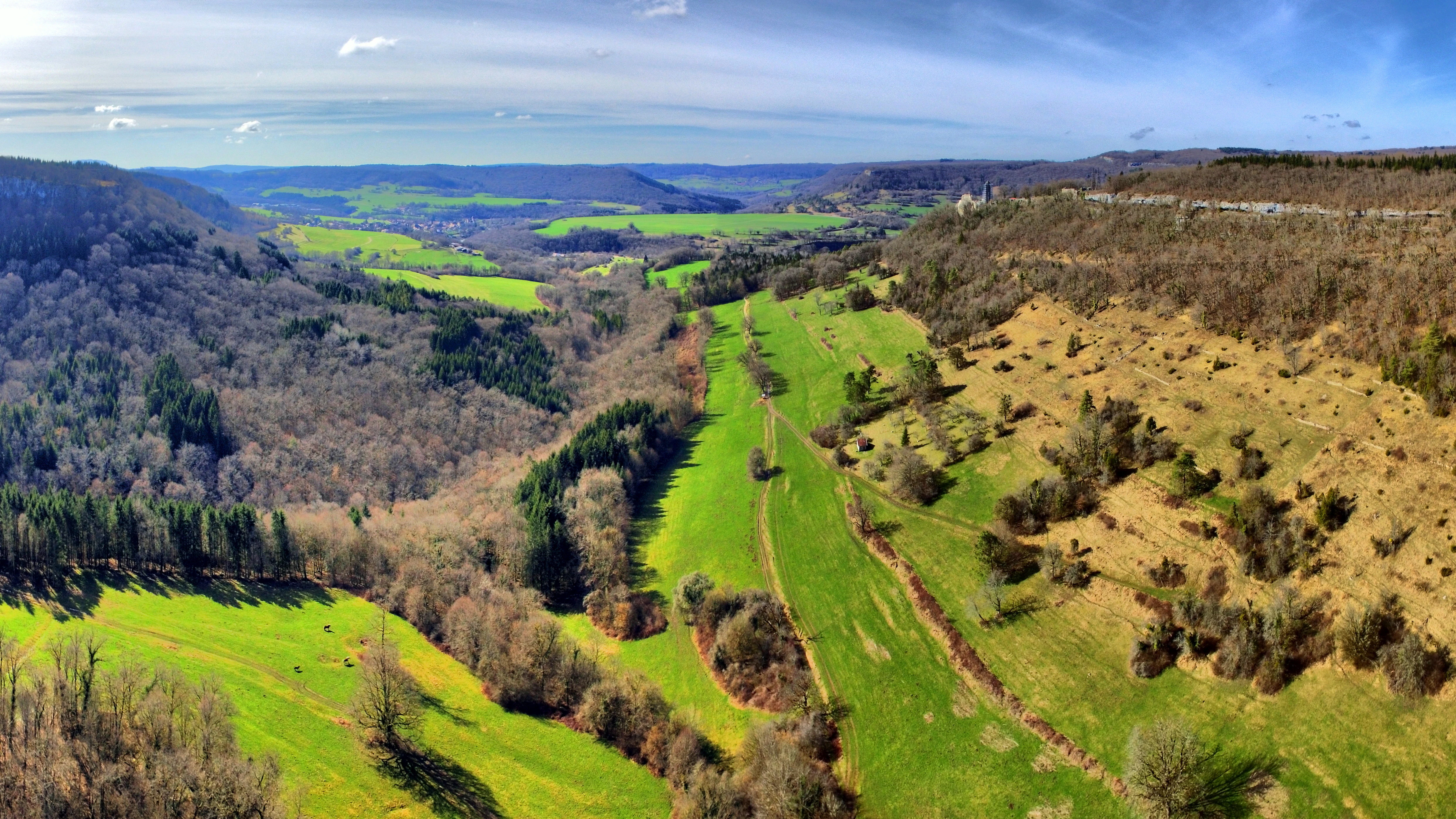
A high-angle panoramic landscape view showing a green valley merging with a larger valley, characterized by mixed forests and limestone slopes
The confluence of the Ravin de Valbois into the Loue Valley near Cléron

Réserve naturelle nationale du ravin de Valbois wildlife and species highlights

The reserve is nationally recognized for its invertebrate fauna. More than 700 butterfly and moth species have been recorded, including rare taxa such as the Dryad and the Woodland Brown, which have become locally uncommon elsewhere in France. Other notable insects include the sulphur ascalaphid, a Mediterranean-montane species, the small mountain cicada, and the ringed goldenring dragonfly, which breeds in seepages on well-exposed slopes. Insect diversity was in fact a central argument in the original protection case, and the invertebrate fauna continues to be one of the main scientific justifications for the reserve.

Mammals are well represented given the small area. Common species include European hare and red fox, while more notable records include wildcat and chamois, the latter reflecting the rocky, cliff-rich terrain. The mustelid community includes European badger and pine marten, and bats are particularly diverse, with recorded species including western barbastelle and greater horseshoe bat. Eurasian lynx occasionally visits the reserve, taking advantage of its forested and rocky cover.

The reserve supports roughly 70 breeding bird species, including peregrine falcon, red kite, black woodpecker, red-backed shrike, and woodlark, several of which benefit from the combination of open cliffs, dry grassland, and extensive forest. The reptile fauna is also notable, with eight of the twelve reptile species recorded in Franche-Comté present, including smooth snake and western green lizard, the latter being particularly rare at this altitude in the Doubs department. In the stream, brown trout and bullhead complete the vertebrate fauna.
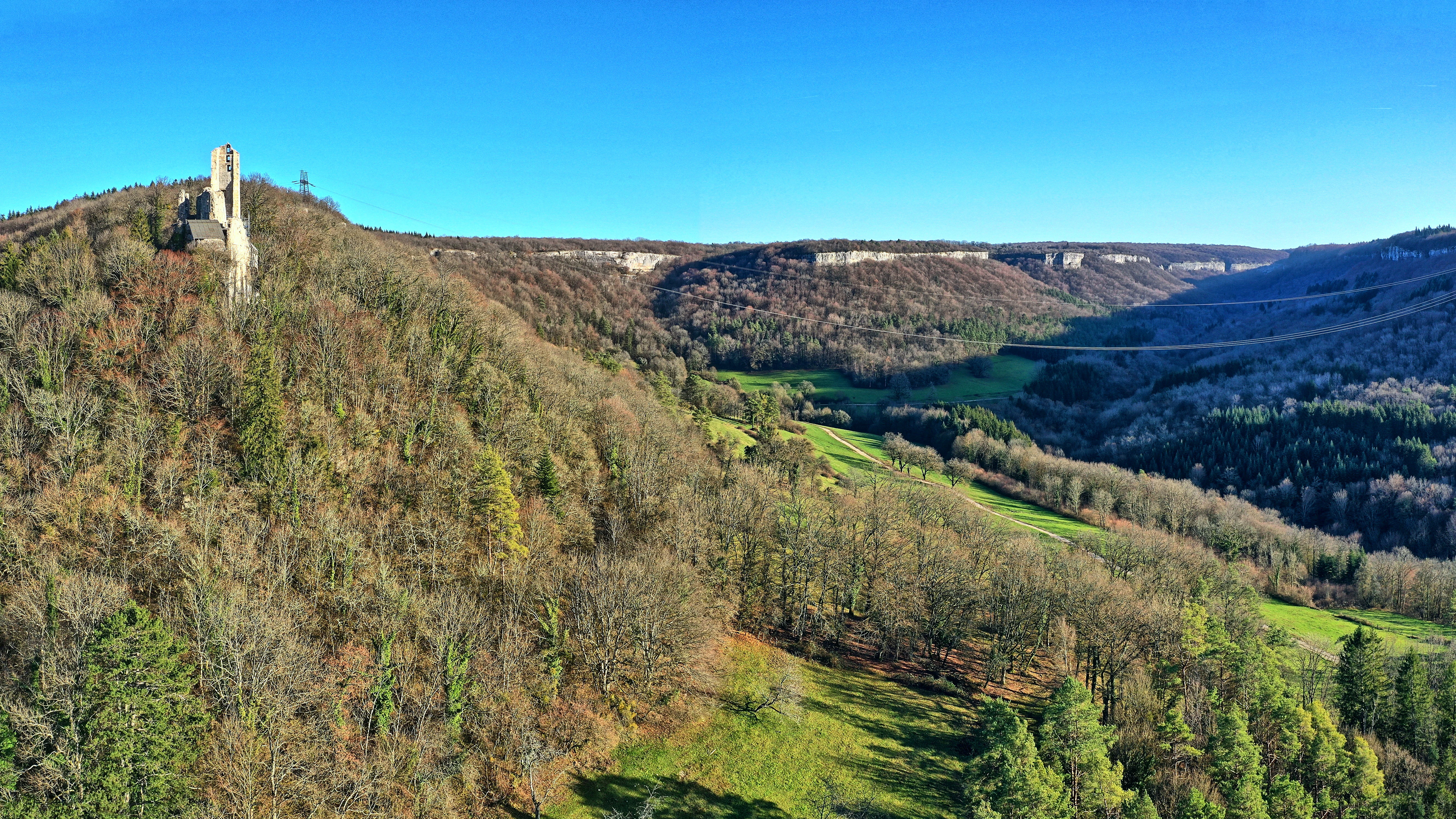
An elevated view of a forested ravine landscape with a ruined stone castle tower perched on a hillside in the foreground and limestone cliffs lining the valley.
Château de Scey overlooking the Ravin de Valbois, a characteristic limestone ravine in the Bourgogne-Franche-Comté region.

Réserve naturelle nationale du ravin de Valbois conservation status and protection priorities

The reserve was created explicitly to safeguard habitats and species of national interest, and its conservation value is unusually high for a site of its size. The combination of cliff dry grasslands, old-growth forest, and humid ravine habitats within a few hundred meters of each other has produced concentrations of rare species, especially among butterflies, plants, and bats. Botanical counts include 13 regionally protected plant species, while the bryophyte flora includes protected mosses such as Tortella nitida.

The reserve is embedded within a broader network of overlapping protections. It sits within the ZNIEFF type II of the upper Loue valley and the closer ZNIEFF type I of the Valbois valley and Chassagne corniche, and it lies partly within the Natura 2000 Special Area of Conservation of the upper Loue valley. The surrounding upper Loue valley is also an inscribed site, and the Château Saint-Denis ruins above the ravine are themselves a classified historic monument. This layered protection reflects both the natural and the cultural importance of the site.

Since 2014, the reserve has been managed by the Conservatoire d'espaces naturels de Franche-Comté, which succeeded the local federation for nature and environment protection. Management has been organized through successive five-year plans, validated by the Doubs prefecture and the regional scientific council for natural heritage, covering habitat conservation, public use, and ecological monitoring. Strict regulations prohibit collecting plants, rocks, or fossils, disturbing wildlife, lighting fires, camping, fishing, bringing dogs (except for hunting), and motor-vehicle access, while organized hikes, cycling, and equestrian activities require advance authorization.

Réserve naturelle nationale du ravin de Valbois cultural meaning and human context

The Valbois ravine carries a layered human history that is unusually visible in the landscape. The most obvious marker is the Château Saint-Denis, perched on the rim of the reculée where it opens onto the Loue valley; its ruins are both a classified historic monument and an archaeological site, listed since 1934 and classified since 1987. The castle looks directly into the ravine and has long framed how the site is experienced by visitors arriving from the valley.

Equally important is the agricultural legacy. Until the late nineteenth century, the south-facing slopes of the ravine, like much of the upper Loue valley, were planted with vineyards rather than forest. The phylloxera epidemic and the broader rural collapse of the twentieth century ended this viticultural tradition and led to extensive reforestation. The transition from open vineyard to closed forest is one of the defining historical transformations of the site, and it explains why a landscape that once supported intensive agriculture now hosts old-growth woodland and grassland relicts.

The reserve also serves an active educational role. School and extracurricular programs are run for children in the cantons of Ornans, Amancey, and Quingey, mainly outside the reserve itself, and annual international volunteer workcamps contribute to habitat management. A 4 km discovery trail starting at the Ferme du Pater, below the Château Saint-Denis, allows visitors to cross the main habitats, while guided natural-history outings are organized in the broader Loue valley.
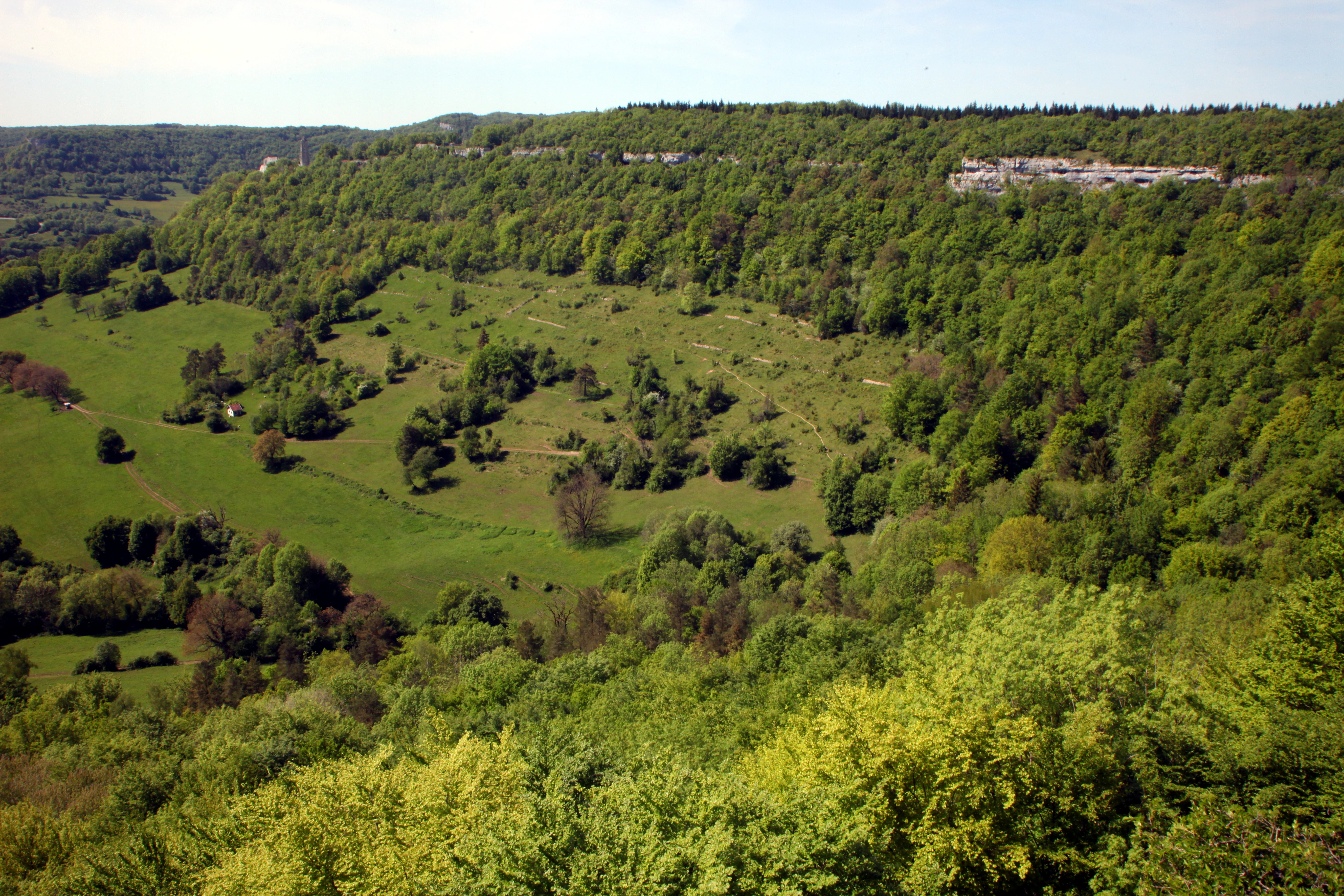
A high-angle view of a valley with lush green hillsides, scattered trees, and exposed limestone rock outcrops along the ridgeline.
A wide view of the limestone cliffs and dry grassland slopes within the Ravin de Valbois nature reserve.

Top sights and standout views in Réserve naturelle nationale du ravin de Valbois

The reserve brings together, in a compact 235 ha site, a textbook Jura reculée, one of France's richest butterfly faunas, and a striking juxtaposition of Mediterranean-montane and true montane plant communities. The contrast between sun-baked cliff grasslands and the cool, humid ravine floor, often only a few hundred meters apart, gives the site its highly distinctive scientific character. The 40-meter Valbois cascade, the silhouette of the Château Saint-Denis at the ravine mouth, and the old-growth forest parcels with abundant deadwood are among the most immediately recognizable features of the reserve.

Equally distinctive are the rare and protected components of the flora and fauna, including regionally protected mosses, the dryad butterfly, chamois, wildcat, peregrine falcon, red-backed shrike, and occasional visits by Eurasian lynx. The layered network of ZNIEFF, Natura 2000, and historic-m monument protections reflects the site's combined natural, landscape, and heritage value, while its long history of management under successive five-year plans demonstrates sustained institutional commitment to its conservation.
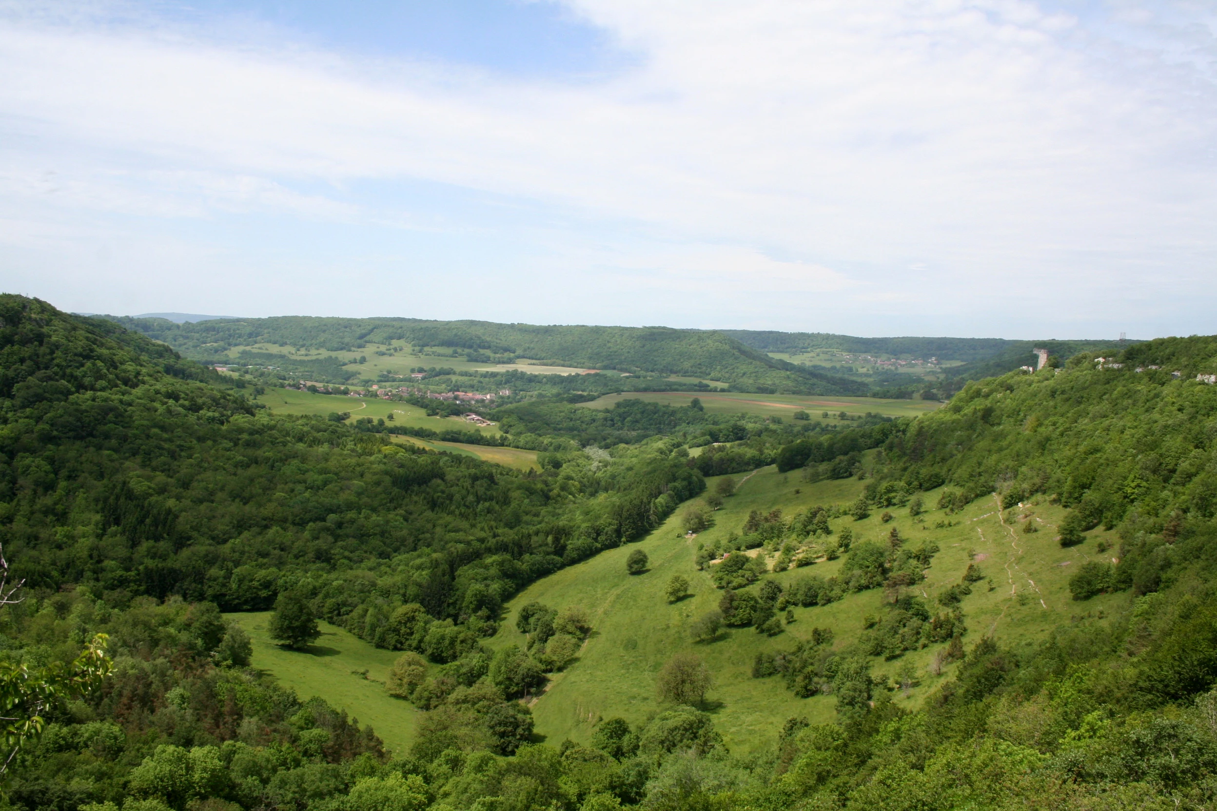
A wide, high-angle view overlooking a lush, green, U-shaped valley with steep, forested cliffs on the sides and a gentle grassy slope in the foreground under a light blue sky with wispy clouds.
Panoramic view of the Reculée de Valbois, showcasing the steep, forested slopes and grassy valley typical of the jurassien reculée landscape.

Best time to visit Réserve naturelle nationale du ravin de Valbois

The reserve is best understood through the seasonal contrast between its dry cliff-top grasslands and its humid ravine floor. Late spring and early summer, roughly May into June, are the most rewarding period for the butterfly fauna and for the dry grassland flora, when mountain kidney-vetch, rock buckthorn, and branched thesium are in flower on the sun-exposed ledges and many butterfly species are at peak activity. Early summer is also a good time for orchids on the dry slopes, including rare species such as the Ophrys frelon recorded here.

Late summer and early autumn bring a different character. The Mediterranean-montane element continues to be visible on the cliffs, while the ravine floor remains cool and humid, supporting montane relict plants and a steady presence of amphibians along seepage zones. Autumn visits also reveal the broader Loue valley landscape in a quieter, less leafy state, making the reculée landform and the cliffs easier to read in low sunlight. Winter visits are generally quieter in terms of flora and insect activity, but the cascade and the geological structure of the cliffs remain striking, though access to some trail sections may be limited by weather.

Monthly climate preview

Long-term representative monthly temperature and precipitation rhythm

Réserve naturelle nationale du ravin de Valbois Climate and Temperature Normals

Representative coordinate measurements track the recorded annual temperature and precipitation cycles across twelve months at Réserve naturelle nationale du ravin de Valbois. Detailed monthly climate normals provide broader context for long-term meteorological patterns at the site.
Annual mean8 °C
0 °C18 °C
Jan
Feb
Mar
Apr
May12°
Jun16°
Jul18°
Aug18°
Sep14°
Oct
Nov
Dec
Warmest month
August

17.7 °C

Coolest month
January

-0.5 °C

Wettest month
December

3.9 mm/day

Driest month
March

2.9 mm/day

Park location guide

Geography guide, regional context, and park location map for Réserve naturelle nationale du ravin de Valbois

Réserve naturelle nationale du ravin de Valbois park geography, regions, and map view in France

Understand where Réserve naturelle nationale du ravin de Valbois sits in France through a broader geographic reading of the surrounding landscape, nearby location context, and its mapped position within the national park landscape.

How Réserve naturelle nationale du ravin de Valbois fits into France

France is a unitary semi-presidential republic and one of the world's largest economies. It borders Belgium, Luxembourg, Germany, Switzerland, Italy, Monaco, Andorra, and Spain, with a maritime border to the United Kingdom. The country is known for its cultural influence, art, cuisine, and political history spanning centuries.

Wider geography shaping Réserve naturelle nationale du ravin de Valbois in France

France is located in Western Europe. Metropolitan France extends from the Rhine to the Atlantic Ocean and from the Mediterranean Sea to the English Channel and North Sea. The country borders Belgium, Luxembourg, Germany, Switzerland, Italy, Monaco, Andorra, Spain, and has a maritime border with the United Kingdom.

Map view of Réserve naturelle nationale du ravin de Valbois

Use this park location map to pinpoint Réserve naturelle nationale du ravin de Valbois in France, understand its exact geographic position, and read its mapped placement within the surrounding landscape more clearly.

Pigeon | © OpenStreetMap contributors

Location context for Réserve naturelle nationale du ravin de Valbois

Bourgogne-Franche-Comté

Visualizing limestone cliffs, steep ravines, and protected Jura habitats

Réserve naturelle nationale du ravin de Valbois Landscape and Scenery Photography

Examine detailed visual records of Réserve naturelle nationale du ravin de Valbois to understand its dramatic limestone topography and diverse microclimates. These photographs capture vertical cliffs, humid ravine floors, and the unique ecological features defining the protected landscape.

A steep, rugged limestone cliff rises above a dense forest in the Valbois ravine, with green trees covering the slopes.

Looking down into a deep, lush green ravine with steep, exposed limestone cliffs on the right side and dense forest covering the slopes under a bright blue sky, viewed through tree branches in the foreground.

A close up, vertical shot of a single late spider orchid showing its pink petals and distinctive dark, patterned labellum against a soft, green out of focus background.

A high-angle panoramic landscape view showing a green valley merging with a larger valley, characterized by mixed forests and limestone slopes

An elevated view of a forested ravine landscape with a ruined stone castle tower perched on a hillside in the foreground and limestone cliffs lining the valley.

A high angle view looking down at a slender waterfall plunging over a rocky, limestone cliff face into a small pool, surrounded by forest vegetation.

A high-angle view of a valley with lush green hillsides, scattered trees, and exposed limestone rock outcrops along the ridgeline.

A wide, high-angle view overlooking a lush, green, U-shaped valley with steep, forested cliffs on the sides and a gentle grassy slope in the foreground under a light blue sky with wispy clouds.

Clusters of bright yellow and pink wildflowers growing on a rocky, grassy ledge overlooking a green valley with scattered trees.

A deep, verdant ravine framed by tall, light-colored limestone cliffs and thick deciduous forest.

Pink mountain kidney vetch flowers growing on a rocky limestone ledge with a blurred background of a forested valley.

A peregrine falcon with dark grey plumage on its head and barred, white and dark brown feathers on its chest and spread wings, perched in front of leafy foliage.

Park atlas

Compare nearby limestone ravines, forest reserves, and regional protected areas in the Jura massif.

Parks Near Réserve Naturelle Nationale du Ravin de Valbois and Surrounding Protected Landscapes

Browse other parks and protected areas located near Réserve naturelle nationale du ravin de Valbois to examine connected Jura landforms. Comparing these regional sites provides broader context on limestone plateau topography and local conservation corridors.
Watercolor painting of a hilly landscape featuring green rolling hills, a rocky cliff formation to the right, and trees against a soft white background.
Nature reserveBourgogne-Franche-Comté
About 11 km away#1 closest

Northwest

Réserve naturelle régionale des grottes de Chenecey: Protected Karst and Limestone Cliffs

Regional Nature Reserve in the Doubs, France

This nature reserve protects a diverse mosaic of habitats along the Loue valley. The site integrates surface calcareous grasslands with fragile underground cave galleries, providing critical refuge for rare bat species. It represents a significant conservation effort in the Jura region, mapping the intersection of subterranean voids and exposed limestone terrain.

Area
0.214 km²
Established
2017
IUCN
IV
Relief
Upland
Nature reserveBourgogne-Franche-Comté
About 21 km away#2 closest

West

Réserve naturelle régionale du gouffre du Creux à Pépé: Protected Karst and Bat Landscapes

Jura foothills nature reserve with critical cave habitats

Located in the Doubs department, the Réserve naturelle régionale du gouffre du Creux à Pépé protects a rare limestone sinkhole within a mosaic of dry calcareous grassland. This site stands as a key node in regional bat conservation efforts, providing essential wintering and spring transit roosts within the Jura mountain foothills, all anchored by a dense network of biotope and Natura 2000 protective instruments.

Area
0.007 km²
Established
2015
IUCN
IV
Relief
Upland
Wildlife reserveBourgogne-Franche-Comté
About 21 km away#3 closest

South

Tourbières et lacs de la montagne jurassienne: Mapping High-Altitude Wetlands and Glacial Landscapes

A vast protected wildlife reserve in the Bourgogne-Franche-Comté region

Covering more than 12,000 hectares, this wildlife reserve forms a crucial conservation benchmark for peatland and glacial lake systems in the Jura Massif. The landscape encompasses deep combes, broad plateaus, and clear-water basins like Lac de Saint-Point, providing a vital habitat mosaic for diverse flora and fauna across the French highlands.

Area
121.56 km²
Established
2021
Relief
Mountain
Climate
Temperate
A watercolor illustration of a landscape with green forest, wetland grasses, and pale mountains in the background, set against a clean white background.
Nature reserveBourgogne-Franche-Comté
About 27 km away#4 closest

South

Réserve naturelle régionale des tourbières de Frasne-Bouverans Protected Landscape Atlas

Peatland mosaic geography in the Drugeon valley of Bourgogne-Franche-Comté

Trace the boundaries and ecological features of this significant regional nature reserve. Spanning the Forbonnet massif and the wider Drugeon basin, the area features a dense concentration of raised bogs, woodlands, and mire habitats defined by complex glacial geology.

Area
2.926 km²
Established
1986
IUCN
IV
Visitors
17.5K annual
A horizontal watercolor painting showing a soft, misty landscape with coniferous trees, grassy wetlands, and rolling hills in the background, executed in a muted color palette.
Nature reserveBourgogne-Franche-Comté
About 32 km away#5 closest

South

Réserve naturelle régionale de la Seigne des Barbouillons Protected Landscape Atlas

Geography and wetland boundaries in the Jura plateau of France

The Réserve naturelle régionale de la Seigne des Barbouillons protects a characteristic raised bog ecosystem in the Mignovillard commune. This compact area serves as a vital reference point for understanding the distribution of sphagnum mires and specialized butterfly habitats across the Jura plateau, illustrating the contrast between protected peatlands and their surrounding agricultural environment.

Area
0.346 km²
Established
2014
IUCN
IV
Relief
Upland
Nature reserveBourgogne-Franche-Comté
About 34 km away#6 closest

Northwest

Réserve naturelle régionale de la grotte de Beaumotte: Protected Karst and Cave Landscapes

A regional nature reserve focused on subterranean conservation.

Located in the Haute-Saône department, this regional nature reserve protects a critical limestone cave system that supports complex subterranean ecosystems and bat species of regional concern. The site occupies a modest surface area on the edge of the Monts de Gy massif, yet provides significant geological and ecological value through its horizontal gallery network and captured springs.

Area
0.088 km²
Established
2015
IUCN
IV
Relief
Upland
A soft watercolor painting of a green, hilly landscape with small groups of trees, set against a white background.
Nature reserveBourgogne-Franche-Comté
About 37 km away#7 closest

Northwest

Réserve naturelle régionale du vallon de Fontenelay: Protected Area Atlas and Map

High-density marly grasslands and wetland seepage slopes

Situated in the Haute-Saône department, this nature reserve features a distinct valley landscape formed by marly soil and limestone. Explore the site's rich biodiversity including alkaline marshes and its significant role in the regional conservation network for northeastern France.

Area
0.416 km²
Established
2010
IUCN
IV
Relief
Upland
A horizontal watercolor painting depicting a soft, impressionistic landscape with rolling green hills, pale yellow fields, and a sparse line of trees against a white background.
Nature reserveBourgogne-Franche-Comté
About 40 km away#8 closest

Southwest

Réserve naturelle régionale des grottes de la côte de la Baume, Jura Regional Nature Reserve

Karst caves and cliff-slope forest geography in France

Located in the Bourgogne-Franche-Comté region, this nature reserve protects a vital network of karst caves and unmanaged scree-slope ash forests. The site represents a specialized conservation effort centered on cliff-side habitats and underground sanctuaries within the Jura limestone landscape.

Area
0.054 km²
Established
2017
IUCN
IV
Relief
Upland

Common questions about visiting, size, designation, and location context for Réserve naturelle nationale du ravin de Valbois

Réserve naturelle nationale du ravin de Valbois FAQs for park facts, access, geography, and protected area context

Find quick answers about Réserve naturelle nationale du ravin de Valbois, including protected-area facts, park geography, trail and visitor context, and how the park fits into its surrounding country and regional landscape.
MoriAtlas Explorer

Continue Your Protected Areas Search Across the Global Atlas

Deepen your exploration by continuing the structured search for national parks and protected areas worldwide. Utilize the comprehensive filtering capabilities to compare different conservation landscapes and refine your understanding of global park geography. Discover more about the distribution and characteristics of protected natural areas.

Global natural geography